This 121.9-mile drive from Applewood to Pueblo, Colorado, is a straightforward trip that can easily be completed in a single day, taking approximately 2 hours and 19 minutes. You'll primarily navigate along North Valley Highway, Ronald Reagan Highway, and John F. Kennedy Memorial Highway. With a fuel cost estimated at $18, this route offers a budget-friendly journey. The drive is characterized by its turn-heavy local feel, suggesting a more intimate experience with the landscape rather than a high-speed interstate cruise. Both your origin and destination are within the Mountain West region, so expect consistent regional scenery.
Trip Pace
Same-day drive is realistic
A same-day return is realistic if you keep stops short.
Midpoint
61 miles from Applewood, CO
A natural place for your longest stop of the day
, about 1h 13m into the drive
.
Main Roads
Road
Distance
Duration
North Valley Highway
60.6 mi
1h 5m
Ronald Reagan Highway
22.9 mi
23m
John F. Kennedy Memorial Highway
12.9 mi
12m
Monument Valley Freeway
8.8 mi
10m
North Freeway
5.2 mi
6m
West 6th Avenue Freeway
5 mi
6m
West 20th Avenue
1.5 mi
3m
Simms Street
1.5 mi
3m
Longest stretch:
North Valley Highway
— 60.6 mi, about 1h 5m
Turn-by-Turn Driving Directions
Step-by-step road directions between Applewood, CO and Pueblo, CO.
1
Start on Garden Road
372 ft·16 sec·Garden Road
2
Continue on Berry Road
0.3 mi·1 min·Berry Road
3
Turn right onto CR 18
0.7 mi·1 min·Eldridge Street
4
At end of road, turn left onto West 20th Avenue
0.2 mi·27 sec·West 20th Avenue
5
Turn left onto West 20th Avenue
1.3 mi·3 min·West 20th Avenue
6
Turn right onto Simms Street
1.5 mi·3 min·Simms Street
7
Continue on Union Boulevard
0.1 mi·22 sec·Union Boulevard
8
Turn left
0.5 mi·1 min
Toward US 6 EastUse the straight / left lanes.
9
Merge onto US 6
5.0 mi·6 min·West 6th Avenue Freeway
Use the straight / slight right lanes.
10
Take the exit onto US 6
0.6 mi·59 sec·US 6
Toward I 25: Fort Collins, Colorado SpringsUse the straight / slight right lanes.
11
Take the exit
0.5 mi·1 min
Toward I 25 South: Colorado Springs
12
Merge onto I 25
61 mi·1 hr 5 min·North Valley Highway
Use the straight / slight right lanes.
13
Continue on I 25
8.8 mi·10 min·Monument Valley Freeway
Use the straight / slight right lanes.
14
Continue on I 25; US 24
0.2 mi·12 sec·Ronald Reagan Highway
15
Keep slight left at fork onto I 25
23 mi·23 min·Ronald Reagan Highway
Use the straight / slight right lanes.
16
Continue on I 25
13 mi·12 min·John F. Kennedy Memorial Highway
Use the straight / slight right lanes.
17
Continue on I 25
2.6 mi·2 min·North Freeway
Use the straight / slight right lanes.
18
Take the exit
0.4 mi·32 sec
Exit 100BToward 29th Street
19
Merge onto I 25; US 50
1.0 mi·1 min·North Freeway
20
Take the exit
0.1 mi·12 sec
Exit 99BToward 13th StreetUse the slight right lane.
21
Continue on this road
0.2 mi·18 sec·this road
22
Merge onto I 25; US 50 Bus
1.6 mi·2 min·North Freeway
Use the straight lane.
23
Take the exit
107 ft·2 sec
Toward Abriendo Avenue
24
Arrive at destination
Toward Abriendo Avenue
Trip Plan
For this 121.9-mile journey, flexibility is key since it's a comfortable one-day drive. Aim for an early morning departure to maximize your time in Pueblo and avoid any potential afternoon local traffic. With a 2-hour and 19-minute estimated duration and a $18 fuel cost, it's an efficient trip. Since there are no designated stops in the data, plan your own breaks as needed, perhaps utilizing the 60.6-mile stretch on North Valley Highway as a point to assess your timing. Keep an eye on your fuel, especially as you transition between the main roads mentioned.
Morning Departure
Leave by 9 AM and you'll arrive before lunch.
Evening Departure
Even a 4 PM departure gets you there before dark in summer.
You can normally do this drive in one day.
You may only need one short stretch break if traffic stays light.
The halfway point lands around 61 miles from Applewood, CO, or about 1h 13m into the drive.
The longest continuous stretch on this route runs about 60.6 miles.
This is a comfortable same-day trip.
Departure
Before you leave
Start with fuel, water, and navigation already sorted so the first hour feels easy.
First stop
Around 27 miles or 37m in
Use this first pause for coffee, a restroom break, and a quick traffic check ahead.
Halfway reset
Around 61 miles or 1h 13m in
This is the best place for your longest stop, a real meal, and a full fuel check.
Final approach
Final hour starts around 1h 55m
Traffic, exits, and arrival timing usually matter more near Pueblo, CO than in the middle of the route.
Before You Leave
+
Open the route before leaving Applewood, CO so your first major turns are already loaded.
+
Leave with enough water and a charging cable within reach, not packed away.
+
Check your fuel range against the first long segment, especially if you are starting outside city service areas.
Day 1
Settle into the route from Applewood, CO
This is one driving day of about 121.9 miles and 2h 19m.
Your first comfortable stop window is around 27 miles from Applewood, CO.
This route can stay practical as a one-day drive if traffic stays reasonable.
The longest stretch is on North Valley Highway for about 60.6 miles.
Where to Stop
Rest stops, refuel points, and overnight suggestions along this route.
Place data sourced from public business listings. Hours and availability may vary.
Heads-up: tricky spots
5 of 15
5 decision points cluster between mile 1 and 120 — GPS handles the exact turns, but know they're coming. Your lane choice matters more than the turn itself.
5
1 mi into trip|~3m in|West 20th Avenue
At end of road, turn left onto West 20th Avenue
Navigation decision point
7
4.1 mi into trip|~10m in
Turn left toward US 6 East
Lane positioning matters here
Use the straight / left lanes.
Toward US 6 East
7
9.7 mi into trip|~17m in|US 6
Take the exit onto US 6 toward I 25: Fort Collins, Colorado Springs
Exit ramp - move to the correct lane early. Lane positioning matters here. Multiple destination signs - pick the right one
Use the straight / slight right lanes.
Toward I 25: Fort Collins, Colorado Springs
6
80.3 mi into trip|~1h 35m in|I 25 / Ronald Reagan Highway
Keep slight left at fork onto I 25 / Ronald Reagan Highway
Highway fork - watch signs carefully. Lane positioning matters here
Use the straight / slight right lanes.
7
120 mi into trip|~2h 16m in
Take the exit toward 13th Street
Exit ramp - move to the correct lane early. Lane positioning matters here
Use the slight right lane.
Exit 99B
Toward 13th Street
Fuel & Cost
Regular Gas
$18.37 one way
$36.73 round trip
$3.83/gal25.4 MPG avg43 kg CO2
Fuel Type
$/gal
One Way
Round Trip
midgrade
$4.05
$19.45
$38.89
premium
$4.39
$21.09
$42.18
diesel
$5.61
$26.91
$53.83
No toll roads detected on this route.
Estimated Trip Cost (one way, 1 person)
Fuel
$18
Meals
$25–$50
Total
$43–$68
Rough estimate based on US averages. Hotel $80–$140/night, meals $25–$50/day.
Estimated CO2 emission: 42.7 kg one way.
Prices: EIA weekly data, 2026-04-13.
Driving Electric?
About $13 in charging
· 0 stops
· 67% less CO2
Vehicle Type
kWh
Stops
DC Fast
Home Charge
Average EV
36.6
0
$12.80
$5.85
Efficient EV
30.5
0
$10.67
$4.88
EV Truck/SUV
48.8
0
$17.07
$7.80
Gas CO2
43 kg
EV CO2
14 kg (67% less)
This trip is well within single-charge range for most EVs. No charging stops needed if you start fully charged.
DC fast charging avg $0.35/kWh. Home charging avg $0.16/kWh. US grid CO2: 0.39 kg/kWh.
Travel Intel
Current conditions at both ends of the drive.
Forecast as of Apr 15, 2026
Origin
Applewood, CO
Night
in Applewood on Saturday
Local time
10:38 PM
MDT
Current temp
44°F
Unavailable
Live forecast
Destination
Pueblo, CO
Night
in Pueblo on Saturday
Local time
10:38 PM
MDT
Current temp
81°F
Unavailable
Live forecast
Seasonal Notes
Summer travel usually means heavier construction, hotter rest stops, and busier weekend traffic around major cities.
Winter travel shortens daylight, so a route that looks manageable on paper can feel much longer after dark.
Holiday weekends tend to make both departure and arrival windows slower than the raw route time suggests.
Time zone
Same local time
Origin and destination are on the same clock, so arrival timing is easier to judge at a glance.
Temperature spread
37 degrees warmer at arrival
A meaningful temperature swing is a good cue to rethink layers, water, and how soon you want to arrive.
Road read
2h 19m on the road
Use the two city cards together: check the sky where you start, then compare it with the local time and temperature at arrival.
Weather data from the National Weather Service. Conditions may change; check closer to your travel date.
National Parks Near This Route
Worth a detour if your schedule allows.
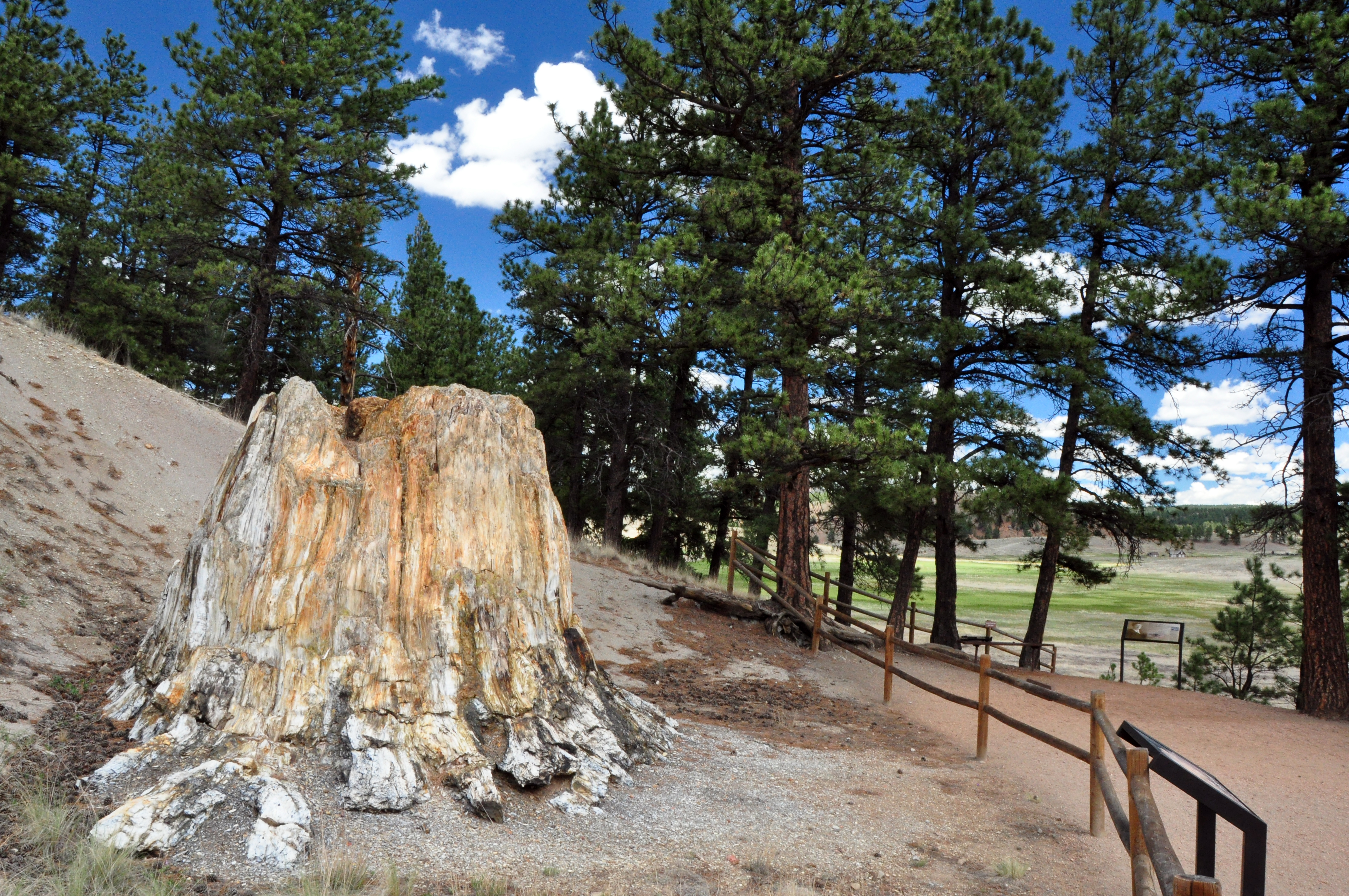
Florissant Fossil Beds National Monument
National Monument
Beneath a grassy mountain valley in central Colorado lies one of the richest and most diverse fossil deposits in the world. Petrified redwood stumps up to 14 feet wide and thousands of detailed fossil...
24 mi from route
~61 min detour
$10
near mile 75.7
Park data from the National Park Service API. Alerts update every 2 hours.
More Details
What kind of drive is this?
Expect a 'turn-heavy local drive' for this 121.9-mile route, meaning you'll encounter more frequent turns and potentially slower speeds than on a pure interstate. While 16% of your journey will be on highways, the majority will feel like navigating local roads. The longest uninterrupted stretch you'll experience is 60.6 miles on North Valley Highway, offering a period of consistent travel before you transition back to more varied segments. This drive is less about high-speed transit and more about engaging with the local road network.
Only 16% highway — the rest is turn-by-turn surface driving.
24 navigation steps total — most of the decisions cluster near the start and finish.
Longest single stretch: 60.6 mi on North Valley Highway.
How Hard Is This Drive?
9/10
Expect a hands-on drive with frequent turns and local roads rather than long highway stretches. This route has several spots where lane changes, forks, or exits need your full attention. The trickiest moment comes around 1 miles in near West 20th Avenue.
Driving Effort9/10
High effort - long or complex enough to need steady focus all day
Balances navigation complexity with total wheel time.
This is a demanding drive. With 15 significant decision points across 121.9 miles, you will need to stay alert - especially through interchange areas and urban stretches. Consider splitting it into segments if you are not comfortable with fast highway navigation.
Where does it get tricky?
The main spots that need attention: at 1 miles (West 20th Avenue): Navigation decision point; at 4.1 miles: Lane positioning matters here; at 9.7 miles (US 6): Exit ramp - move to the correct lane early. Lane positioning matters here. Multiple destination signs - pick the right one.
Elevation Profile
High-altitude sections with notable climbs
6,913 ft4,691 ft
Total Climb
1,547 ft
Total Descent
2,436 ft
Highest Point
6,913 ft
~52.3 mi in
Elevation Range
2,221 ft
Notable High Points
6,913 ft at ~52.3 miles+43 ft prominence
Towns Mentioned on Route Signs
Based on OSRM destination-sign hints, not a full list of every settlement the road passes.
On the drive from Applewood, CO to Pueblo, CO, road signs begin pointing toward Colorado Springs along the way.
Colorado Springs
9.7 mi in|~17m|via US 6
Who Is This Route For?
Weekend Trip
Doable as a same-day drive at 2h 19m. Total distance: 121.9 miles.
Family Friendly
Moderate complexity with 0 natural rest stops along the way.
Solo Traveler
2h 19m drive, comfortable solo distance.
Scenic Drive
Mostly surface roads route profile with national parks nearby.
Frequently Asked Questions
The longest stretch is about 60.6 miles on North Valley Highway. The full list of main roads is in the Roads section above.
It helps. This route has a higher-than-average number of complex decision points, which get harder in the dark. If the last hour of the trip is on surface roads or mountain grades, aim to arrive at Pueblo, CO before sunset when you can. Check the Trip Plan for departure windows that land you in daylight.
Only with planning. This is a long drive for kids — consider splitting it into two days rather than pushing through. Dedicated rest areas are limited, so plan gas or food stops as your bathroom breaks.
The main spots that need attention: at 1 miles (West 20th Avenue): Navigation decision point; at 4.1 miles: Lane positioning matters here; at 9.7 miles (US 6): Exit ramp - move to the correct lane early. Lane positioning matters here. Multiple destination signs - pick the right one.
Yes — Florissant Fossil Beds National Monument. See the National Parks section for detour distances and tips on detours.
Yes. A round trip is manageable in a single day if you plan a break at Pueblo, CO before heading back.