Spanning 139.7 miles, the drive from Altamont to Bend is a straightforward journey that typically takes about 2 hours and 29 minutes. Because of the manageable distance, this route works perfectly as a single-day trip, allowing you to reach your destination without needing an overnight stay. You should budget approximately $28 for fuel to cover the distance. The route guides you through the Pacific Coast region, utilizing Crater Lake Parkway, The Dalles-California Highway, and the Bend Parkway to navigate between these two Oregon hubs. It is a practical, efficient path for travelers looking to move between these locations reliably.
Trip Pace
Same-day drive is realistic
A same-day return is realistic if you keep stops short.
Break Rhythm
1 planned break
A short stop every 2 to 3 hours is enough for this drive.
Midpoint
69.6 miles from Altamont, OR
A natural place for your longest stop of the day
, about 1h 25m into the drive
.
Main Roads
Road
Distance
Duration
The Dalles-California Highway
130.7 mi
2h 38m
Crater Lake Parkway
4.6 mi
7m
Bend Parkway
3 mi
5m
Northwest Sisemore Street
0.3 mi
<1m
Northwest Franklin Avenue
0.3 mi
1m
Northwest Colorado Avenue
0.2 mi
<1m
Southeast Scott Street
<0.1 mi
<1m
Longest stretch:
The Dalles-California Highway
— 130.7 mi, about 2h 38m
Turn-by-Turn Driving Directions
Step-by-step road directions between Altamont, OR and Bend, OR.
1
Start on US 97 Business; OR 39
110 ft·8 sec·Crater Lake Parkway
2
Continue on US 97 Business; OR 39
4.6 mi·6 min·Crater Lake Parkway
3
Continue on US 97
131 mi·2 hr 38 min·The Dalles-California Highway
4
Continue on US 97
3.0 mi·5 min·Bend Parkway
5
Take the exit
0.2 mi·21 sec
Toward Downtown Bend, Mount Bachelor
6
At end of road, turn right onto Southeast Scott Street
238 ft·5 sec·Southeast Scott Street
7
Continue on Northwest Colorado Avenue
0.2 mi·33 sec·Northwest Colorado Avenue
8
Turn right onto Northwest Sisemore Street
0.3 mi·55 sec·Northwest Sisemore Street
9
Turn left onto Northwest Franklin Avenue
0.3 mi·1 min·Northwest Franklin Avenue
10
Arrive at destination
Northwest Franklin Avenue
Trip Plan
Since this is a 2-hour and 29-minute trip without scheduled stops, you have the flexibility to depart whenever fits your schedule best. Given the turn-heavy nature of these local roads, planning your departure during daylight hours is a smart way to ensure better visibility and a more comfortable driving experience. Be sure to fuel up before you head out, keeping in mind the $28 estimated cost for the trip. Because the route relies entirely on local roads rather than major interstate systems, remain patient with traffic flow and varying speed limits throughout your journey. Your primary advantage here is the ability to complete the entire transit in one efficient push, so pack your essentials accordingly before leaving Altamont.
Morning Departure
Leave by 9 AM and you'll arrive before lunch.
Evening Departure
Even a 4 PM departure gets you there before dark in summer.
You can normally do this drive in one day.
Plan roughly 1 meaningful break for fuel, food, and rest.
The halfway point lands around 69.6 miles from Altamont, OR, or about 1h 25m into the drive.
The longest continuous stretch on this route runs about 130.7 miles.
This is a comfortable same-day trip.
Departure
Before you leave
Start with fuel, water, and navigation already sorted so the first hour feels easy.
First stop
Around 31 miles or 39m in
Use this first pause for coffee, a restroom break, and a quick traffic check ahead.
Halfway reset
Around 69.6 miles or 1h 25m in
This is the best place for your longest stop, a real meal, and a full fuel check.
Final approach
Final hour starts around 2h 19m
Traffic, exits, and arrival timing usually matter more near Bend, OR than in the middle of the route.
Before You Leave
+
Open the route before leaving Altamont, OR so your first major turns are already loaded.
+
Leave with enough water and a charging cable within reach, not packed away.
+
Check your fuel range against the first long segment, especially if you are starting outside city service areas.
Day 1
Settle into the route from Altamont, OR
This is one driving day of about 139.3 miles and 2h 53m.
Your first comfortable stop window is around 31 miles from Altamont, OR.
This route can stay practical as a one-day drive if traffic stays reasonable.
Plan about 1 real break rather than only quick fuel stops.
The longest stretch is on The Dalles-California Highway for about 130.7 miles.
Where to Stop
Rest stops, refuel points, and overnight suggestions along this route.
Place data sourced from public business listings. Hours and availability may vary.
Heads-up: tricky spots
4 of 4
4 decision points cluster between mile 138.3 and 139 — GPS handles the exact turns, but know they're coming. Your lane choice matters more than the turn itself.
5
138.3 mi into trip|~2h 50m in
Take the exit toward Downtown Bend, Mount Bachelor
Exit ramp - move to the correct lane early. Multiple destination signs - pick the right one
Toward Downtown Bend, Mount Bachelor
5
138.4 mi into trip|~2h 50m in|Southeast Scott Street
At end of road, turn right onto Southeast Scott Street
Navigation decision point
4
138.7 mi into trip|~2h 51m in|Northwest Sisemore Street
Turn right onto Northwest Sisemore Street
Navigation decision point
5
139 mi into trip|~2h 52m in|Northwest Franklin Avenue
Turn left onto Northwest Franklin Avenue
Navigation decision point
Fuel & Cost
Regular Gas
$27.75 one way
$55.50 round trip
$5.06/gal25.4 MPG avg49 kg CO2
Fuel Type
$/gal
One Way
Round Trip
midgrade
$5.36
$29.37
$58.74
premium
$5.59
$30.66
$61.32
diesel
$5.61
$30.76
$61.51
No toll roads detected on this route.
Estimated Trip Cost (one way, 1 person)
Fuel
$28
Meals
$25–$50
Total
$53–$78
Rough estimate based on US averages. Hotel $80–$140/night, meals $25–$50/day.
Estimated CO2 emission: 48.7 kg one way.
Prices: EIA weekly data, 2026-04-13.
Driving Electric?
About $15 in charging
· 0 stops
· 67% less CO2
Vehicle Type
kWh
Stops
DC Fast
Home Charge
Average EV
41.8
0
$14.63
$6.69
Efficient EV
34.8
0
$12.19
$5.57
EV Truck/SUV
55.7
0
$19.50
$8.92
Gas CO2
49 kg
EV CO2
16 kg (67% less)
This trip is well within single-charge range for most EVs. No charging stops needed if you start fully charged.
DC fast charging avg $0.35/kWh. Home charging avg $0.16/kWh. US grid CO2: 0.39 kg/kWh.
Travel Intel
Current conditions at both ends of the drive.
Forecast as of Apr 15, 2026
Origin
Altamont, OR
Evening
in Altamont on Saturday
Local time
7:53 PM
PDT
Current temp
34°F
Unavailable
Live forecast
Destination
Bend, OR
Evening
in Bend on Saturday
Local time
7:53 PM
PDT
Current temp
35°F
Unavailable
Live forecast
Seasonal Notes
Summer travel usually means heavier construction, hotter rest stops, and busier weekend traffic around major cities.
Winter travel shortens daylight, so a route that looks manageable on paper can feel much longer after dark.
Holiday weekends tend to make both departure and arrival windows slower than the raw route time suggests.
Time zone
Same local time
Origin and destination are on the same clock, so arrival timing is easier to judge at a glance.
Temperature spread
1 degrees warmer at arrival
A meaningful temperature swing is a good cue to rethink layers, water, and how soon you want to arrive.
Road read
2h 53m on the road
Use the two city cards together: check the sky where you start, then compare it with the local time and temperature at arrival.
Weather data from the National Weather Service. Conditions may change; check closer to your travel date.
National Parks Near This Route
Worth a detour if your schedule allows.
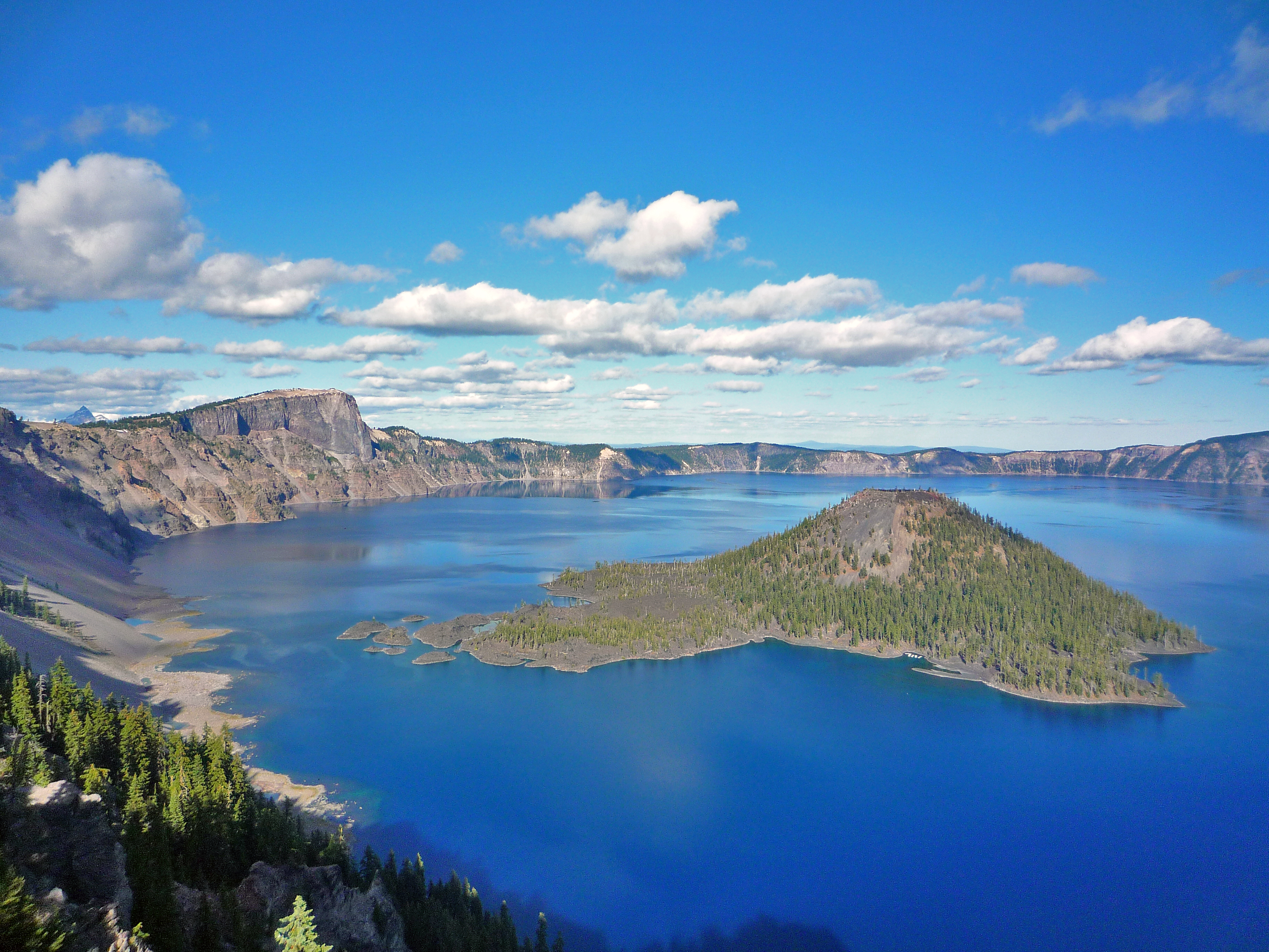
Crater Lake National Park
National Park
Crater Lake inspires awe. Native Americans witnessed its formation 7,700 years ago, when a violent eruption triggered the collapse of a tall peak. Scientists marvel at its purity—fed by rain and snow,...
16 mi from route
~39 min detour
$30
near mile 52.8
Park Closure: Cleetwood Cove Trail is CLOSED for Rehabilitation
Park Closure: North Entrance Road and Rim Drive are CLOSED for the Season
Park data from the National Park Service API. Alerts update every 2 hours.
More Details
What kind of drive is this?
Expect a turn-heavy local drive rather than a monotonous interstate cruise on this journey. Because the highway share is 0%, you will spend your time navigating local roads that require more driver attention and engagement than a standard freeway. The route is characterized by its technical nature, keeping you focused on the road ahead as you transition between the various parkways and highways. Since there are no designated stops on this 139.7-mile stretch, the character of the drive remains consistent from start to finish. You will find it to be a more hands-on experience behind the wheel compared to typical high-speed transit routes.
Only 5% highway — the rest is turn-by-turn surface driving.
10 navigation steps total — most of the decisions cluster near the start and finish.
Longest single stretch: 130.7 mi on The Dalles-California Highway.
How Hard Is This Drive?
1/10
Expect a hands-on drive with frequent turns and local roads rather than long highway stretches. Navigation is very simple - set it and forget it for most of the drive. The trickiest moment comes around 138.3 miles in.
Driving Effort1/10
Very easy - short and simple to drive
Balances navigation complexity with total wheel time.
The drive from Altamont, OR to Bend, OR is easy. At 2h 53m with 5% highway, most drivers will find it relaxed and low-stress.
Where does it get tricky?
The main spots that need attention: at 138.3 miles: Exit ramp - move to the correct lane early. Multiple destination signs - pick the right one; at 138.4 miles (Southeast Scott Street): Navigation decision point; at 138.7 miles (Northwest Sisemore Street): Navigation decision point.
Elevation Profile
Gently rolling terrain
4,684 ft3,625 ft
Total Climb
602 ft
Total Descent
1,123 ft
Highest Point
4,684 ft
~69.6 mi in
Elevation Range
1,059 ft
Notable High Points
4,563 ft at ~39.8 miles+3 ft prominence
4,684 ft at ~69.6 miles+124 ft prominence
4,297 ft at ~129.3 miles+61 ft prominence
Who Is This Route For?
Weekend Trip
Doable as a same-day drive at 2h 53m. Total distance: 139.3 miles.
Family Friendly
Moderate complexity with 1 natural rest stops along the way.
Mostly surface roads route profile with national parks nearby.
Frequently Asked Questions
The longest stretch is about 130.7 miles on The Dalles-California Highway. The full list of main roads is in the Roads section above.
Yes, with realistic expectations. Build in a stop roughly every 2 hours, have snacks and activities ready, and check the Nearby Places tabs for kid-friendly stops along the way.
The main spots that need attention: at 138.3 miles: Exit ramp - move to the correct lane early. Multiple destination signs - pick the right one; at 138.4 miles (Southeast Scott Street): Navigation decision point; at 138.7 miles (Northwest Sisemore Street): Navigation decision point.
Yes — Crater Lake National Park. See the National Parks section for detour distances and tips on detours.
Yes. A round trip is manageable in a single day if you plan a break at Bend, OR before heading back.