Origin
Ahwahnee, CA
Late night in Ahwahnee on Tuesday
Local time
5:15 AM
PDT
Current temp
43°F
Unavailable
Live forecast
Compiled and reviewed by the US Trip Planner planning team at COD Solutions Oy · Last reviewed Apr 21, 2026 · Editorial standards
Drive Time
3h 36m
Distance
171.1 mi
275 km
Drive Score
10/10
Great drive
Same Day?
Yes, doable
Fuel Cost
$39
one way
EV Charging
Unknown
Estimated drive times based on typical traffic patterns. Actual times may vary with weather, construction, and real-time conditions.

Ahwahnee, CA
Mazin Omron

Sacramento, CA
Wikimedia Commons
Ahwahnee, CA to Sacramento, CA is 171.1 miles and takes about 3h 36m via CA 99, with a fuel budget near $39 and enough daylight to finish in a day. This one-day drive takes you from the Pacific Coast region of California to the state capital, primarily on highway. It’s a straightforward trip, ideal if you're looking for an efficient way to cover ground without a lot of complex navigation. Expect a highway-focused experience for most of the journey, making it a good option for a quick transit or if you're eager to reach your destination without extensive detours.
Trip Pace
Same-day drive is realistic
A same-day return is realistic if you keep stops short.
Break Rhythm
1 planned break
A short stop every 2 to 3 hours is enough for this drive.
Midpoint
85.5 miles from Ahwahnee, CA
A natural place for your longest stop of the day , about 1h 55m into the drive .
| Road | Distance | Duration |
|---|---|---|
| CA 99 | 111.4 mi | 2h 9m |
| Central Yosemite Highway | 35.6 mi | 49m |
| Boot Jack - Ahwahnee Road | 11.3 mi | 16m |
| CA 49 | 5.3 mi | 7m |
| Boot Jack Road | 4.4 mi | 6m |
| L Street | 1.1 mi | 2m |
| I Street | 0.5 mi | 1m |
| Capital City Freeway | 0.5 mi | <1m |
Step-by-step road directions between Ahwahnee, CA and Sacramento, CA.
Start on CA 49
Continue on CA 49
Turn straight onto CA 49
Turn left
Turn left onto CA 140
Take the ramp
Merge onto CA 99; CA 140
Continue on CA 99; CA 59; CA 140
Keep slight left at fork onto CA 99
Continue on Capital City Freeway
Take the exit
Turn left onto 30th Street
Turn left onto L Street
Turn right onto US 40 Historic
Turn left onto I Street
Turn left onto 9th Street
Arrive at destination
Given the 3h 36m estimated drive time, this route is easily manageable in a single day. Aim to depart in the morning to maximize daylight and allow for any unforeseen traffic. The longest stretch without significant turns is 111.4 miles on CA 99, so plan your fuel stops accordingly, perhaps before you get onto this long highway segment. With only one recommended stop, you have flexibility in your timing, but remember that rest stops are less frequent on the main highway stretches.
Morning Departure
An early start around 7-8 AM gets you there with plenty of daylight left.
Evening Departure
A late afternoon start means arriving after dark. Morning is better.
This is a comfortable same-day trip.
Departure
Before you leave
Start with fuel, water, and navigation already sorted so the first hour feels easy.
First stop
Around 38 miles or 55m in
Use this first pause for coffee, a restroom break, and a quick traffic check ahead.
Halfway reset
Around 85.5 miles or 1h 55m in
This is the best place for your longest stop, a real meal, and a full fuel check.
Final approach
Final hour starts around 2h 59m
Traffic, exits, and arrival timing usually matter more near Sacramento, CA than in the middle of the route.
Open the route before leaving Ahwahnee, CA so your first major turns are already loaded.
Leave with enough water and a charging cable within reach, not packed away.
Check your fuel range against the first long segment, especially if you are starting outside city service areas.
Day 1
Settle into the route from Ahwahnee, CA
This is one driving day of about 171.1 miles and 3h 36m.
Rest stops, refuel points, and overnight suggestions along this route.

Mid-route town
Meal stop
86 mi into the route
Best for: Lunch, fuel, and a longer reset
This sits close to the middle of the route, so it works well for the longest stop of the day.
A short stop after about 38 miles helps settle the day before fatigue starts building.
The midpoint is around 85.5 miles from Ahwahnee, CA, which is a good place for a longer meal and fuel stop.
Before the longest stretch
Fuel checkTop up before CA 99 if your tank is already low. That segment runs about 111.4 miles.
These stop ideas are pacing suggestions — the exact town or exit can change with traffic, hotel plans, and fuel range.
5 decision points cluster between mile 21 and 170.5 — GPS handles the exact turns, but know they're coming. Your lane choice matters more than the turn itself.
Turn left onto CA 140 / Central Yosemite Highway
Lane positioning matters here
Keep slight left at fork onto CA 99
Highway fork - watch signs carefully. Lane positioning matters here
Take the exit toward N Street
Exit ramp - move to the correct lane early. Lane positioning matters here
Turn left onto L Street
Lane positioning matters here
Turn left onto I Street
Lane positioning matters here
Regular Gas
$39.33 one way
$78.65 round trip
| Fuel Type | $/gal | One Way | Round Trip |
|---|---|---|---|
| midgrade | $6.02 | $40.53 | $81.05 |
| premium | $6.18 | $41.61 | $83.22 |
| diesel | $5.61 | $37.78 | $75.55 |
No toll roads detected on this route.
Estimated Trip Cost (one way, 1 person)
Fuel
$39
Meals
$25–$50
Total
$64–$89
Rough estimate based on US averages. Hotel $80–$140/night, meals $25–$50/day.
Estimated CO2 emission: 59.9 kg one way. Prices: EIA weekly data, 2026-04-13.
Driving Electric?
About $18 in charging · 0 stops · 67% less CO2
| Vehicle Type | kWh | Stops | DC Fast | Home Charge |
|---|---|---|---|---|
| Average EV | 51.3 | 0 | $17.97 | $8.21 |
| Efficient EV | 42.8 | 0 | $14.97 | $6.84 |
| EV Truck/SUV | 68.4 | 0 | $23.95 | $10.95 |
Gas CO2
60 kg
EV CO2
20 kg (67% less)
This trip is well within single-charge range for most EVs. No charging stops needed if you start fully charged.
DC fast charging avg $0.35/kWh. Home charging avg $0.16/kWh. US grid CO2: 0.39 kg/kWh.
Current conditions at both ends of the drive.
Origin
Late night in Ahwahnee on Tuesday
Local time
5:15 AM
PDT
Current temp
43°F
Unavailable
Destination
Late night in Sacramento on Tuesday
Local time
5:15 AM
PDT
Current temp
51°F
Unavailable
Seasonal Notes
Summer travel usually means heavier construction, hotter rest stops, and busier weekend traffic around major cities.
Winter travel shortens daylight, so a route that looks manageable on paper can feel much longer after dark.
Holiday weekends tend to make both departure and arrival windows slower than the raw route time suggests.
Time zone
Origin and destination are on the same clock, so arrival timing is easier to judge at a glance.
Temperature spread
A meaningful temperature swing is a good cue to rethink layers, water, and how soon you want to arrive.
Road read
Use the two city cards together: check the sky where you start, then compare it with the local time and temperature at arrival.
Weather data from the National Weather Service. Conditions may change; check closer to your travel date.
Worth a detour if your schedule allows.
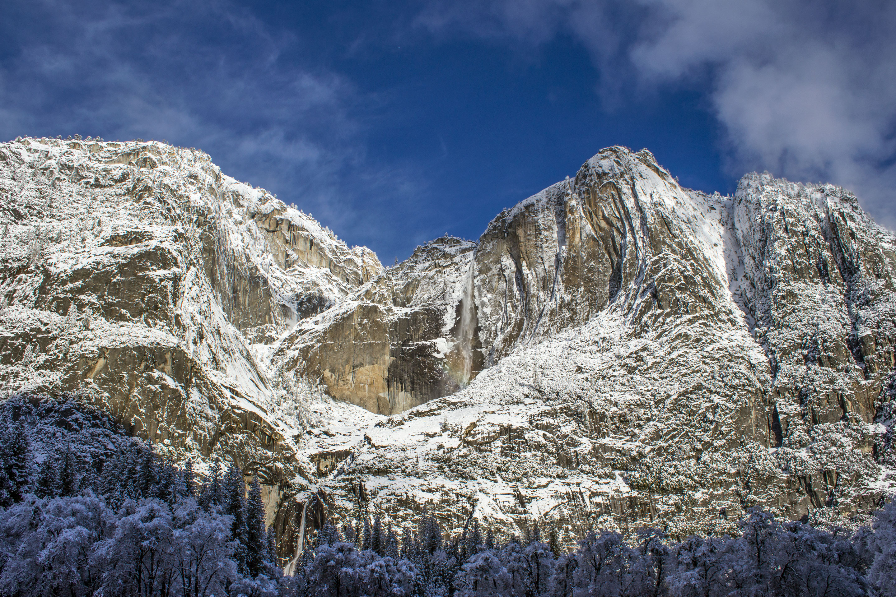
National Park
Not just a great valley, but a shrine to human foresight, the strength of granite, the power of glaciers, the persistence of life, and the tranquility of the High Sierra. First protected in 1864, Yose...
Park data from the National Park Service API. Alerts update every 2 hours.
This drive is predominantly highway-focused, with 69% of the route utilizing major roadways. You'll experience a significant uninterrupted stretch of 111.4 miles on CA 99, offering a consistent pace. The journey begins on local roads like Boot Jack - Ahwahnee Road and Central Yosemite Highway before merging onto the faster-paced CA 99. This transition means you'll start with more winding local routes before settling into a more direct, high-speed transit.
This is a straightforward highway drive that stays mostly on CA 99 and Central Yosemite Highway. You will hit about 10 points where you need to pay attention to lane position or signs. The trickiest moment comes around 21 miles in near CA 140 / Central Yosemite Highway.
Moderate - straightforward overall, but long enough or busy enough to require pacing
Balances navigation complexity with total wheel time.
This drive requires moderate attention. Across 171.1 miles you will encounter 10 spots where lane choice or exit timing matters. Not difficult for experienced highway drivers, but worth previewing the tricky sections before you go.
Where does it get tricky?
The main spots that need attention: at 21 miles (CA 140 / Central Yosemite Highway): Lane positioning matters here; at 123.6 miles (CA 99): Highway fork - watch signs carefully. Lane positioning matters here; at 168.8 miles: Exit ramp - move to the correct lane early. Lane positioning matters here.
Founded 1849
Sacramento is the state capital of California in the United States. It is the regional center for the Greater Sacramento metropolitan area, which dominates much of the surrounding Sacramento Valley and stretches into parts of Gold Country. Sacramento is the oldest incorporated city in California, settled between the confluences of the Sacramento and American rivers. The city has been the site of many important historic events that have shaped California and U.S. history, most notably the California Gold Rush and location of the original terminus of the First Transcontinental Railroad. Much of this historical legacy has been preserved, especially in the historic Old Sacramento district, where buildings and railroads from that era continue to attract visitors. However, Sacramento is not a city that is stuck in the past. As the capital of the most populous U.S.
Top landmarks
City content from Wikivoyage (CC BY-SA 4.0) and Wikidata (CC0).
Weekend Trip
Doable as a same-day drive at 3h 36m. Total distance: 171.1 miles.
Family Friendly
Moderate complexity with 1 natural rest stops along the way.
Solo Traveler
3h 36m drive, comfortable solo distance.
First-Time Driver
Mostly highway driving (69%). Some complex stretches to watch for.
Compiled by the US Trip Planner planning team at COD Solutions Oy from open government datasets — OSRM over OpenStreetMap for geometry, EIA for fuel prices, and NPS for national parks. See our methodology for refresh cadence and limitations.
Was this helpful?
Thanks for your feedback!
Your tip has been submitted. Thanks!
/500
Recent Tips
·
Explore more options from Ahwahnee, CA or browse trips ending in Sacramento, CA.
Looking for more statewide routes? Browse CA road trips.