Spanning 136.1 miles, the journey from Waterville to Spokane is a straightforward trip that typically takes about 3 hours and 5 minutes behind the wheel. Because of the manageable distance, this route works perfectly as a single-day excursion, meaning you won't need to worry about booking an overnight stay. You should plan for a fuel budget of approximately $29, depending on your vehicle's efficiency. You will stay within the Pacific Coast region for the duration of the drive, keeping the experience consistent from start to finish. It is a practical, no-nonsense path for those looking to reach Spokane efficiently while enjoying a mix of local road character.
Trip Pace
Same-day drive is realistic
A same-day return is realistic if you keep stops short.
Break Rhythm
1 planned break
A short stop every 2 to 3 hours is enough for this drive.
Midpoint
68 miles from Waterville, WA
A natural place for your longest stop of the day
, about 1h 24m into the drive
.
Main Roads
Road
Distance
Duration
Sunset Highway
117.5 mi
2h 28m
West Sunset Highway
4.8 mi
10m
Coulee Corridor / Sunset Highway
4.2 mi
6m
US 2
3.8 mi
5m
West Broadway Avenue
1 mi
2m
Morgan Street
0.9 mi
2m
West Watson Street
0.7 mi
1m
East Poplar Street
0.5 mi
1m
Longest stretch:
Sunset Highway
— 117.5 mi, about 2h 28m
Turn-by-Turn Driving Directions
Step-by-step road directions between Waterville, WA and Spokane, WA.
1
Start on South Chelan Avenue
0.1 mi·26 sec·South Chelan Avenue
2
Turn right onto US 2
0.5 mi·1 min·East Poplar Street
3
Continue on US 2
38 mi·44 min·Sunset Highway
4
Continue on US 2
4.2 mi·6 min·Coulee Corridor / Sunset Highway
5
Turn slight right onto Sunset Highway
28 mi·35 min·Sunset Highway
Toward Spokane
6
Continue on US 2
0.2 mi·29 sec·West Main Avenue
7
Continue on US 2
0.3 mi·51 sec·Northwest Main Avenue
8
Continue on US 2
0.2 mi·23 sec·East Main Street
9
Continue on US 2
0.5 mi·1 min·East Main Avenue
10
Continue on US 2
7.8 mi·9 min·Sunset Highway
11
Continue on US 2
0.7 mi·1 min·West Watson Street
12
Continue on US 2
20 mi·24 min·Sunset Highway
13
Continue on US 2
0.9 mi·2 min·Morgan Street
14
Continue on US 2
12 mi·15 min·Sunset Highway
15
Continue on US 2; WA 231
1.0 mi·2 min·West Broadway Avenue
16
Continue on US 2
13 mi·18 min·Sunset Highway
17
Keep slight right at fork onto US 2
1.8 mi·4 min·West Sunset Highway
18
Enter roundabout onto West Sunset Highway
95 ft·1 sec·West Sunset Highway
19
Continue on West Sunset Highway
1.0 mi·2 min·West Sunset Highway
Use the left / straight / right lanes.
20
Enter roundabout onto US 2
97 ft·2 sec·West Sunset Highway
21
Continue on US 2
2.0 mi·3 min·West Sunset Highway
22
Turn straight onto US 2
3.8 mi·5 min·US 2
23
Take the exit
0.2 mi·31 sec
Toward Maple Street, Lincoln Street, Walnut Street
24
Continue on West 5th Avenue
382 ft·12 sec·West 5th Avenue
25
Turn straight onto West Freeway Avenue
0.2 mi·32 sec·West Freeway Avenue
26
Continue on West 4th Avenue
0.2 mi·31 sec·West 4th Avenue
27
Continue on West 4th Avenue
167 ft·4 sec·West 4th Avenue
28
Continue on South Lincoln Street
0.4 mi·1 min·South Lincoln Street
Use the straight / left lanes.
29
Turn left onto West Main Avenue
0.2 mi·34 sec·West Main Avenue
30
Turn right
26 ft·8 sec
31
Turn left onto South Gorge Trail
157 ft·17 sec·South Gorge Trail
32
Arrive at destination
South Gorge Trail
Trip Plan
Since this is a one-day trip, you have plenty of flexibility regarding your departure time, though starting in the morning will help you avoid fatigue on the more technical sections. Plan for at least one stop to stretch your legs and refuel, which will help you manage the 136.1-mile distance comfortably. Keep a close eye on your fuel gauge during the 117.5-mile stretch on the Sunset Highway to ensure you don't run low between service points. Because the route is turn-heavy, focus on maintaining a steady, moderate pace to handle the curves safely. Taking advantage of that single planned stop will make the three-hour duration feel much shorter and more manageable.
Morning Departure
An early start around 7-8 AM gets you there with plenty of daylight left.
Evening Departure
A late afternoon start means arriving after dark. Morning is better.
You can normally do this drive in one day.
Plan roughly 1 meaningful break for fuel, food, and rest.
The halfway point lands around 68 miles from Waterville, WA, or about 1h 24m into the drive.
The longest continuous stretch on this route runs about 117.5 miles.
This is a comfortable same-day trip.
Departure
Before you leave
Start with fuel, water, and navigation already sorted so the first hour feels easy.
First stop
Around 30 miles or 36m in
Use this first pause for coffee, a restroom break, and a quick traffic check ahead.
Halfway reset
Around 68 miles or 1h 24m in
This is the best place for your longest stop, a real meal, and a full fuel check.
Final approach
Final hour starts around 2h 22m
Traffic, exits, and arrival timing usually matter more near Spokane, WA than in the middle of the route.
Before You Leave
+
Open the route before leaving Waterville, WA so your first major turns are already loaded.
+
Leave with enough water and a charging cable within reach, not packed away.
+
Check your fuel range against the first long segment, especially if you are starting outside city service areas.
Day 1
Settle into the route from Waterville, WA
This is one driving day of about 136.1 miles and 3h 5m.
Your first comfortable stop window is around 30 miles from Waterville, WA.
This route can stay practical as a one-day drive if traffic stays reasonable.
Plan about 1 real break rather than only quick fuel stops.
The longest stretch is on Sunset Highway for about 117.5 miles.
Where to Stop
Rest stops, refuel points, and overnight suggestions along this route.
Place data sourced from public business listings. Hours and availability may vary.
Heads-up: tricky spots
5 of 9
5 decision points cluster between mile 0.1 and 136 — GPS handles the exact turns, but know they're coming. Your lane choice matters more than the turn itself.
4
0.1 mi into trip|~0m in|US 2 / East Poplar Street
Turn right onto US 2 / East Poplar Street
Navigation decision point
4
126.1 mi into trip|~2h 44m in|US 2 / West Sunset Highway
Keep slight right at fork onto US 2 / West Sunset Highway
Highway fork - watch signs carefully
5
134.7 mi into trip|~3h in
Take the exit toward Maple Street, Lincoln Street, Walnut Street
Exit ramp - move to the correct lane early. Multiple destination signs - pick the right one
Toward Maple Street, Lincoln Street, Walnut Str...
5
136 mi into trip|~3h 4m in
Turn right
Navigation decision point
5
136 mi into trip|~3h 4m in|South Gorge Trail
Turn left onto South Gorge Trail
Navigation decision point
Fuel & Cost
Regular Gas
$28.48 one way
$56.97 round trip
$5.32/gal25.4 MPG avg48 kg CO2
Fuel Type
$/gal
One Way
Round Trip
midgrade
$5.58
$29.87
$59.74
premium
$5.77
$30.91
$61.81
diesel
$5.61
$30.05
$60.10
No toll roads detected on this route.
Estimated Trip Cost (one way, 1 person)
Fuel
$28
Meals
$25–$50
Total
$53–$78
Rough estimate based on US averages. Hotel $80–$140/night, meals $25–$50/day.
Estimated CO2 emission: 47.6 kg one way.
Prices: EIA weekly data, 2026-04-13.
Driving Electric?
About $14 in charging
· 0 stops
· 67% less CO2
Vehicle Type
kWh
Stops
DC Fast
Home Charge
Average EV
40.8
0
$14.29
$6.53
Efficient EV
34
0
$11.91
$5.44
EV Truck/SUV
54.4
0
$19.05
$8.71
Gas CO2
48 kg
EV CO2
16 kg (67% less)
This trip is well within single-charge range for most EVs. No charging stops needed if you start fully charged.
DC fast charging avg $0.35/kWh. Home charging avg $0.16/kWh. US grid CO2: 0.39 kg/kWh.
Travel Intel
Current conditions at both ends of the drive.
Forecast as of Apr 18, 2026
Origin
Waterville, WA
Night
in Waterville on Saturday
Local time
11:00 PM
PDT
Current temp
36°F
Mostly Cloudy
E 2 mph0% chanceLive forecast
Destination
Spokane, WA
Night
in Spokane on Saturday
Local time
11:00 PM
PDT
Current temp
45°F
Unavailable
Live forecast
Seasonal Notes
Summer travel usually means heavier construction, hotter rest stops, and busier weekend traffic around major cities.
Winter travel shortens daylight, so a route that looks manageable on paper can feel much longer after dark.
Holiday weekends tend to make both departure and arrival windows slower than the raw route time suggests.
Time zone
Same local time
Origin and destination are on the same clock, so arrival timing is easier to judge at a glance.
Temperature spread
9 degrees warmer at arrival
A meaningful temperature swing is a good cue to rethink layers, water, and how soon you want to arrive.
Road read
3h 5m on the road
The weather snapshot is not static. If you are leaving later, give both cities one more quick forecast check before departure.
Weather data from the National Weather Service. Conditions may change; check closer to your travel date.
National Parks Near This Route
Worth a detour if your schedule allows.
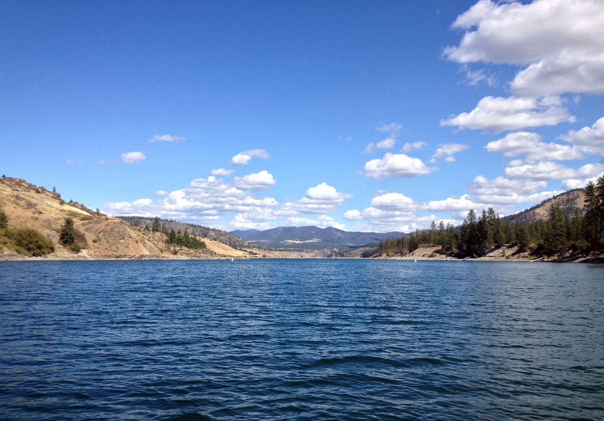
Lake Roosevelt National Recreation Area
National Recreation Area
The ancient geologic landscape of the upper Columbia River cradles Lake Roosevelt in walls of stone carved by massive ice age floods. Come explore the shorelines and learn the stories of American Indi...
30 mi from route
~74 min detour
Free
near mile 79.8
Park Closure: Hawk Creek Area Closed for 2026 Recreation Season
Park Closure: Fort Spokane Museum and Visitor Center to Close for Repairs
Park data from the National Park Service API. Alerts update every 2 hours.
More Details
What kind of drive is this?
Expect a turn-heavy local drive that demands your full attention rather than a monotonous interstate cruise. While the route relies on a highway share of 3, you will spend the vast majority of your time—specifically 117.5 miles—navigating the Sunset Highway. This longest stretch defines the core of your journey, transitioning from local roads into the primary corridor. As you progress through the Sunset Highway, West Sunset Highway, and the Coulee Corridor, the road conditions shift, requiring you to navigate various turns. It is a technical driving experience that keeps you engaged throughout the entire three-hour transit.
Only 3% highway — the rest is turn-by-turn surface driving.
32 navigation steps total — most of the decisions cluster near the start and finish.
Longest single stretch: 117.5 mi on Sunset Highway.
How Hard Is This Drive?
3/10
Expect a hands-on drive with frequent turns and local roads rather than long highway stretches. There are only a few real navigation decisions along the way. The trickiest moment comes around 0.1 miles in near US 2 / East Poplar Street.
Driving Effort3/10
Easy - simple navigation with a manageable amount of wheel time
Balances navigation complexity with total wheel time.
This is a straightforward 3h 5m drive. You will face about 9 decision points, but nothing that requires special attention if you follow navigation.
Where does it get tricky?
The main spots that need attention: at 0.1 miles (US 2 / East Poplar Street): Navigation decision point; at 126.1 miles (US 2 / West Sunset Highway): Highway fork - watch signs carefully; at 134.7 miles: Exit ramp - move to the correct lane early. Multiple destination signs - pick the right one.
Who Is This Route For?
Weekend Trip
Doable as a same-day drive at 3h 5m. Total distance: 136.1 miles.
Family Friendly
Moderate complexity with 1 natural rest stops along the way.
Mostly surface roads route profile with national parks nearby.
Frequently Asked Questions
The longest stretch is about 117.5 miles on Sunset Highway. The full list of main roads is in the Roads section above.
We did not find dedicated rest areas on this route. For a drive this long, plan bathroom and stretch breaks around gas stations, fast-food stops, or small-town downtowns — check the Nearby Places section for options.
Yes, with realistic expectations. Build in a stop roughly every 2 hours, have snacks and activities ready, and check the Nearby Places tabs for kid-friendly stops along the way.
The main spots that need attention: at 0.1 miles (US 2 / East Poplar Street): Navigation decision point; at 126.1 miles (US 2 / West Sunset Highway): Highway fork - watch signs carefully; at 134.7 miles: Exit ramp - move to the correct lane early. Multiple destination signs - pick the right one.
Yes — Lake Roosevelt National Recreation Area. See the National Parks section for detour distances and tips on detours.
Possible but tiring. At 3.1 hours each way, an in-and-out day trip would put you behind the wheel for 6.2 hours — manageable with a long break at Spokane, WA, but most travelers stay overnight.