Washington Heights, NY to Grandyle Village, NY is 382.5 miles and takes about 7h 56m via New York State Thruway and I 81, with a fuel budget near $63 and enough daylight to finish in a day. This trip stays within New York, traversing the Northeast region. Expect a drive that mixes major highways with more winding local roads. With only 2 recommended stops and a longest stretch of nearly 100 miles, it's a manageable one-day journey. Plan for about 39% of your drive to be on highways.
Trip Pace
Same-day drive is realistic
A same-day return is possible, but it will make for a full day on the road.
Break Rhythm
2 planned breaks
Plan on a short reset every 3 to 4 hours to stay fresh behind the wheel.
Midpoint
191.2 miles from Washington Heights, NY
A natural place for your longest stop of the day
, about 3h 50m into the drive
.
Main Roads
Road
Distance
Duration
New York State Thruway
99.6 mi
1h 55m
I 81
97.3 mi
1h 55m
Christopher Columbus Highway
68.2 mi
1h 20m
I 380
27.7 mi
30m
Keystone Shortway
17.3 mi
24m
Clinton Street
10.5 mi
15m
East Lake Road
9.9 mi
14m
Chase Street
9.8 mi
11m
Longest stretch:
New York State Thruway
— 99.6 mi, about 1h 55m
Traffic on I-80
Hour-of-day weekday pattern from 168 FHWA count stations on your route.
Peak
3 PM
~4,210 veh/hr typical
· worst 4,900
Quietest
1 AM
~430 veh/hr
Peak-to-quiet ratio
9.8×
busier at peak than in the quiet hours
12a6anoon6p11p
Averaged across 52 weeks of 2023 FHWA Travel Monitoring Analysis System data. Weekday hours only (Mon–Fri).
Turn-by-Turn Driving Directions
Step-by-step road directions between Washington Heights, NY and Grandyle Village, NY.
1
Start on US 9
0.1 mi·26 sec·Broadway
2
Turn right onto US 9
0.1 mi·20 sec·West 179th Street
3
Take the ramp onto US 9
0.3 mi·39 sec·US 9
Toward I 95 South: George Washington Bridge, New Jersey
4
Merge onto I 95; US 1; US 9
0.4 mi·43 sec·George Washington Bridge (upper level)
5
Continue on I 95 EXPR; US 1 EXPR; US 9 EXPR
0.5 mi·48 sec·I 95 EXPR; US 1 EXPR; US 9 EXPR
6
Keep slight left at fork onto I 95 EXPR; US 1 EXPR; US 9 EXPR
0.6 mi·39 sec·I 95 EXPR; US 1 EXPR; US 9 EXPR
Use the straight / slight right lanes.
7
Keep slight left at fork onto I 95 EXPR; NJTP
0.1 mi·8 sec·I 95 EXPR; NJTP
8
Take the exit
0.2 mi·22 sec
Toward I 95 South, NJTP South: HackensackUse the straight / slight right lanes.
9
Keep slight left at fork
0.4 mi·29 sec
Toward I 95 South, NJTP South: HackensackUse the slight left / slight right lanes.
10
Merge onto I 95; NJTP
2.0 mi·2 min·New Jersey Turnpike
Use the straight / slight right lanes.
11
Take the exit
0.8 mi·1 min
Exit 69Toward I 80 West: Paterson, HackensackUse the straight / slight right lanes.
12
Continue on I 80
68 mi·1 hr 20 min·Christopher Columbus Highway
Use the straight / slight right lanes.
13
Keep slight left at fork onto I 80
5.5 mi·8 min·Keystone Shortway
Use the straight / slight right lanes.
14
Keep slight left at fork onto I 80
12 mi·15 min·Keystone Shortway
15
Take the exit
0.7 mi·46 sec
Exit 293Toward I 380 North: Scranton
16
Continue on I 380
28 mi·30 min·I 380
Use the straight lane.
17
Merge onto I 81
58 mi·1 hr 9 min·I 81
Use the straight lane.
18
Keep slight right at fork onto I 81
1.8 mi·2 min·I 81
Toward I 81 North: Syracuse, Albany
19
Keep slight left at fork onto I 81
37 mi·43 min·I 81
Toward I 81 North: Syracuse
20
Take the exit
0.1 mi·21 sec
Exit 52Toward NY 13: Cortland
21
Turn right onto NY 13
39 ft·5 sec·Clinton Avenue
22
Turn left onto Locust Avenue
1.2 mi·2 min·Locust Avenue
23
Continue on Albany Street
0.6 mi·1 min·Albany Street
24
At end of road, turn right onto US 11; NY 41
0.4 mi·1 min·South Main Street
25
Turn left onto NY 41
10 mi·15 min·Clinton Street
26
Continue on NY 41
0.5 mi·49 sec·East Lake Road
27
Continue on NY 41
4.8 mi·7 min·State Route 41
28
Continue on NY 41
9.4 mi·13 min·East Lake Road
29
Continue on NY 41
0.5 mi·48 sec·East Lake Street
30
Turn left onto US 20
7.3 mi·13 min·East Genesee Street
31
Turn right onto US 20
0.2 mi·12 sec·North Fulton Street
32
Turn left onto US 20; NY 5
0.4 mi·1 min·Arterial West
33
Continue on US 20; NY 5; NY 38
9.8 mi·11 min·Chase Street
Use the left lane.
34
Continue on US 20; NY 5
1.9 mi·2 min·Auburn Road
35
Turn right onto NY 318
4.1 mi·7 min·NY 318
36
Continue on NY 318
319 ft·10 sec·NY 318
Use the right lane.
37
Turn right onto NY 414
0.3 mi·28 sec·State Route 414
Use the right lane.
38
Continue on NY 414
217 ft·11 sec·Ridge Road
Use the left lane.
39
Take the ramp
0.2 mi·23 sec
Use the left lane.
40
Keep slight left at fork
0.6 mi·1 min
Toward I 90 West: BuffaloUse the straight / right lanes.
41
Merge onto I 90
100 mi·1 hr 55 min·New York State Thruway
42
Take the exit
0.4 mi·36 sec
Exit 50Toward I 290: Niagara FallsUse the straight / slight right lanes.
43
Continue on I 290
9.5 mi·12 min·Youngmann Expressway
Use the straight / slight right lanes.
44
Keep slight right at fork onto I 190 North / Niagara Falls
0.3 mi·41 sec·I 190 North / Niagara Falls
Toward I 190 North: Niagara FallsUse the slight right lane.
45
Merge onto I 190
1.8 mi·2 min·Niagara Thruway
46
Take the exit onto NY 324
0.3 mi·30 sec·NY 324
Exit 18AToward NY 324: Grand Is Blvd
47
Enter roundabout onto NY 324
258 ft·5 sec·Grand Island Boulevard
48
Continue on NY 324
192 ft·3 sec·Grand Island Boulevard
49
Continue on NY 324
0.8 mi·1 min·South Parkway
50
Turn slight right
370 ft·16 sec
51
Arrive at destination
Trip Plan
Given the 7h 56m duration, starting your drive from Washington Heights early in the morning is advisable to maximize daylight and complete the 382.5 miles comfortably in one day. With only 2 recommended stops, plan them strategically to break up the drive, especially considering the longest stretch is 99.6 miles. Keep an eye on your fuel gauge, as the estimated cost is $63, and while there are highways, the 'turn-heavy local drive' profile means you could encounter stretches where fuel stations are less frequent. Aim to leave before rush hour to get onto the New York State Thruway smoothly.
Morning Departure
Start early — leave by 6-7 AM to arrive at a reasonable hour.
Evening Departure
This is a long drive — plan for a morning departure or consider splitting it into two days.
You can normally do this drive in one day.
Plan roughly 2 meaningful breaks for fuel, food, and rest.
The halfway point lands around 191.2 miles from Washington Heights, NY, or about 3h 50m into the drive.
The longest continuous stretch on this route runs about 99.6 miles.
This is a comfortable same-day trip.
Departure
Before you leave
Start with fuel, water, and navigation already sorted so the first hour feels easy.
First stop
Around 84 miles or 1h 43m in
Use this first pause for coffee, a restroom break, and a quick traffic check ahead.
Halfway reset
Around 191.2 miles or 3h 50m in
This is the best place for your longest stop, a real meal, and a full fuel check.
Final approach
Final hour starts around 6h 43m
Traffic, exits, and arrival timing usually matter more near Grandyle Village, NY than in the middle of the route.
Before You Leave
+
Open the route before leaving Washington Heights, NY so your first major turns are already loaded.
+
Leave with enough water and a charging cable within reach, not packed away.
+
Check your fuel range against the first long segment, especially if you are starting outside city service areas.
+
Pick one backup stop option before the midpoint in case traffic changes your pacing.
Day 1
Settle into the route from Washington Heights, NY
This is one driving day of about 382.5 miles and 7h 56m.
Your first comfortable stop window is around 84 miles from Washington Heights, NY.
This route can stay practical as a one-day drive if traffic stays reasonable.
Plan about 2 real breaks rather than only quick fuel stops.
The longest stretch is on New York State Thruway for about 99.6 miles.
Where to Stop
Rest stops, refuel points, and overnight suggestions along this route.
Place data sourced from public business listings. Hours and availability may vary.
Heads-up: tricky spots
5 of 33
5 decision points cluster between mile 2.2 and 269 — GPS handles the exact turns, but know they're coming. Your lane choice matters more than the turn itself.
8
2.2 mi into trip|~3m in
Take the exit toward I 95 South, NJTP South: Hackensack
Exit ramp - move to the correct lane early. Lane positioning matters here. Multiple destination signs - pick the right one
Use the straight / slight right lanes.
Toward I 95 South, NJTP South: Hackensack
8
2.4 mi into trip|~4m in
Keep slight left at fork toward I 95 South, NJTP South: Hackensack
Highway fork - watch signs carefully. Lane positioning matters here. Multiple destination signs - pick the right one
Use the slight left / slight right lanes.
Toward I 95 South, NJTP South: Hackensack
8
4.8 mi into trip|~7m in
Take the exit toward I 80 West: Paterson, Hackensack
Exit ramp - move to the correct lane early. Lane positioning matters here. Multiple destination signs - pick the right one
Use the straight / slight right lanes.
Exit 69
Toward I 80 West: Paterson, Hackensack
7
268.9 mi into trip|~5h 40m in
Take the ramp
Lane positioning matters here
Use the left lane.
7
269 mi into trip|~5h 40m in
Keep slight left at fork toward I 90 West: Buffalo
Highway fork - watch signs carefully. Lane positioning matters here
Use the straight / right lanes.
Toward I 90 West: Buffalo
Fuel & Cost
Regular Gas
$61.88 one way
$123.76 round trip
$4.11/gal25.4 MPG avg134 kg CO2
Fuel Type
$/gal
One Way
Round Trip
midgrade
$4.46
$67.15
$134.30
premium
$4.85
$73.01
$146.01
diesel
$4.80
$72.22
$144.45
Estimated Tolls: $21.35
George Washington Bridge
$16.00
New York State Thruway
(99.6 mi)$4.98
New Jersey Turnpike
(2 mi)$0.28
Niagara Thruway
(1.8 mi)$0.09
Toll estimates based on average 2024-2025 rates. EZ-Pass/SunPass discounts may lower the actual cost.
Estimated Trip Cost (one way, 1 person)
Fuel
$62
Tolls
$21
Meals
$25–$50
Total
$108–$133
Rough estimate based on US averages. Hotel $80–$140/night, meals $25–$50/day.
Estimated CO2 emission: 133.8 kg one way.
Prices: EIA weekly data, 2026-07-13.
Driving Electric?
About $40 in charging
· 1 stop
· 66% less CO2
Vehicle Type
kWh
Stops
DC Fast
Home Charge
Average EV
114.8
1
$40.16
$18.36
Efficient EV
95.6
1
$33.47
$15.30
EV Truck/SUV
153
1
$53.55
$24.48
Gas CO2
134 kg
EV CO2
45 kg (66% less)
Plan for 1 charging stop. A 30-minute DC fast charge mid-route should be enough to complete the trip comfortably.
DC fast charging avg $0.35/kWh. Home charging avg $0.16/kWh. US grid CO2: 0.39 kg/kWh.
Travel Intel
Current conditions at both ends of the drive.
Forecast as of Jul 17, 2026
Origin
Washington Heights, NY
Morning
in Washington Heights on Sunday
Local time
11:08 AM
EDT
Current temp
71°F
Smoke
NW 6 to 10 mph7% chanceLive forecast
Destination
Grandyle Village, NY
Morning
in Grandyle Village on Sunday
Local time
11:08 AM
EDT
Current temp
64°F
Smoke
N 5 mph0% chanceLive forecast
84°F
Barton, NY
191 mi in
Seasonal Notes
Summer travel usually means heavier construction, hotter rest stops, and busier weekend traffic around major cities.
Winter travel shortens daylight, so a route that looks manageable on paper can feel much longer after dark.
Holiday weekends tend to make both departure and arrival windows slower than the raw route time suggests.
Time zone
Same local time
Origin and destination are on the same clock, so arrival timing is easier to judge at a glance.
Temperature spread
7 degrees cooler at arrival
A meaningful temperature swing is a good cue to rethink layers, water, and how soon you want to arrive.
Road read
7h 56m on the road
Start early — leave by 6-7 AM to arrive at a reasonable hour.
Weather data from the National Weather Service. Conditions may change; check closer to your travel date.
National Parks Near This Route
Worth a detour if your schedule allows.
Hamilton Grange National Memorial
National Memorial
Merchant’s clerk, Revolutionary War soldier, first Secretary Treasury of the United States: Alexander Hamilton’s life is memorialized at The Grange, the home he built on a country estate in uptown Man...
The final resting place of President Ulysses S. Grant and his wife, Julia, is the largest mausoleum in North America. It testifies to a people’s gratitude for the man who ended the bloodiest conflict...
Harriet Tubman was guided by a deep faith and devotion to family, freedom, and community. After emancipating herself and members of her family, she moved them from Ontario, Canada to Fleming and Aubur...
3 mi from route
~6 min detour
Free
near mile 250.6
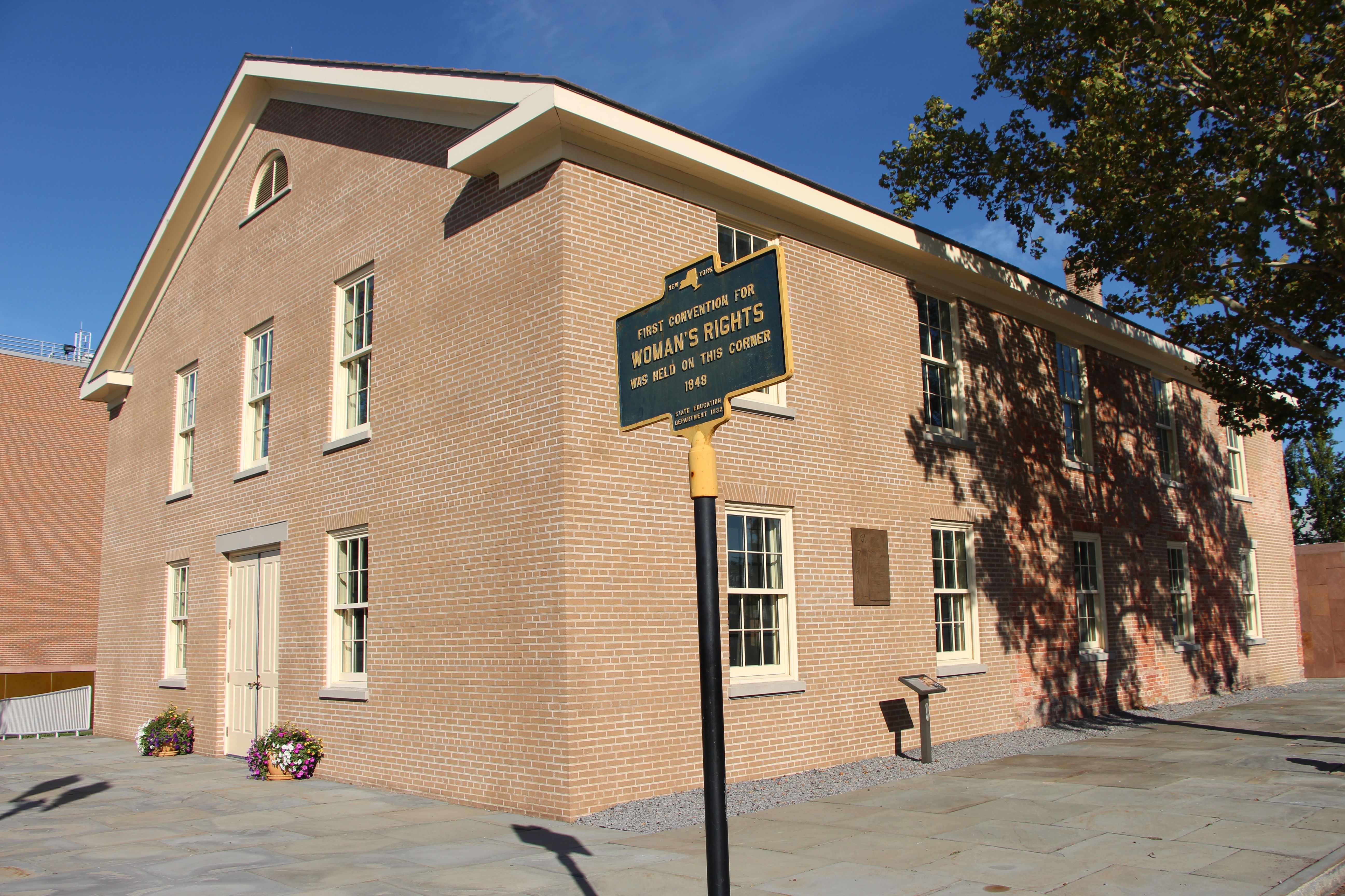
Women’s Rights National Historical Park tells the story of the first Women’s Rights Convention, held in Seneca Falls, New York on July 19-20, 1848. It is a story of struggles for civil rights, human r...
4 mi from route
~11 min detour
Free
near mile 263.8
Before the 1960s, almost everything about living authentically as a lesbian, a bisexual person or a gay man was illegal. The Stonewall Uprising on June 28, 1969 is a milestone in the quest for civil r...
The African Burial Ground stands as the oldest and largest known excavated burial site in North America for both free and enslaved Africans. It offers a profound testament to the enduring legacy of Af...
Park data from the National Park Service API. Alerts update every 2 hours.
More Details
What kind of drive is this?
This route offers a blend of driving experiences. You'll spend roughly 39% of your time on highways, including a significant 99.6-mile stretch on the New York State Thruway. However, the overall profile is described as 'turn-heavy local drive,' suggesting that a good portion of the 7h 56m journey will involve navigating local roads with more frequent turns and potentially lower speeds. Be prepared for the character of the drive to shift as you move between the faster highway segments and the more intricate local road sections.
Only 39% highway — the rest is turn-by-turn surface driving.
51 navigation steps total — most of the decisions cluster near the start and finish.
Longest single stretch: 99.6 mi on New York State Thruway.
How Hard Is This Drive?
10/10
Expect a hands-on drive with frequent turns and local roads rather than long highway stretches. This route has several spots where lane changes, forks, or exits need your full attention. The trickiest moment comes around 2.2 miles in.
Driving Effort10/10
High effort - long or complex enough to need steady focus all day
Balances navigation complexity with total wheel time.
This is a demanding drive. With 33 significant decision points across 382.5 miles, you will need to stay alert - especially through interchange areas and urban stretches. Consider splitting it into segments if you are not comfortable with fast highway navigation.
Where does it get tricky?
The main spots that need attention: at 2.2 miles: Exit ramp - move to the correct lane early. Lane positioning matters here. Multiple destination signs - pick the right one; at 2.4 miles: Highway fork - watch signs carefully. Lane positioning matters here. Multiple destination signs - pick the right one; at 4.8 miles: Exit ramp - move to the correct lane early. Lane positioning matters here. Multiple destination signs - pick the right one.
Elevation Profile
Gently rolling terrain
1,850 ft178 ft
Total Climb
2,249 ft
Total Descent
1,831 ft
Highest Point
1,850 ft
~109.3 mi in
Elevation Range
1,672 ft
Notable High Points
1,850 ft at ~109.3 miles+549 ft prominence
Towns Mentioned on Route Signs
Based on OSRM destination-sign hints, not a full list of every settlement the road passes.
On the drive from Washington Heights, NY to Grandyle Village, NY, road signs begin pointing toward Albany along the way.
Doable as a same-day drive at 7h 56m. Total distance: 382.5 miles.
Family Friendly
Moderate complexity with 2 natural rest stops along the way.
Solo Traveler
7h 56m drive, plan rest stops for pacing.
Scenic Drive
Mostly surface roads route profile with national parks nearby.
Frequently Asked Questions
The longest stretch is about 99.6 miles on New York State Thruway. The full list of main roads is in the Roads section above.
Expect about $21.35 in tolls one way, starting with George Washington Bridge. Most Northeast and Midwest toll agencies accept E-ZPass; in the West and Texas, transponders like TxTag or FasTrak apply. If you do not have a transponder, cashless tolling plates will mail a bill to the vehicle's registered address — usually with a surcharge, so a rental-car toll pass is often cheaper than paying by mail.
Yes — we found about 38 rest areas or service plazas within a short detour of the route (from OpenStreetMap). See the Rest Stops tab under Nearby Places for locations and mile markers. Plan to stretch, use the bathroom, and top off fluids every 2–3 hours on longer drives.
It helps. This route has a higher-than-average number of complex decision points, which get harder in the dark. If the last hour of the trip is on surface roads or mountain grades, aim to arrive at Grandyle Village, NY before sunset when you can. Check the Trip Plan for departure windows that land you in daylight.
Only with planning. This is a long drive for kids — consider splitting it into two days rather than pushing through. Plan at least 2 meaningful breaks. There are 38 rest areas along the route for bathroom stops.
The main spots that need attention: at 2.2 miles: Exit ramp - move to the correct lane early. Lane positioning matters here. Multiple destination signs - pick the right one; at 2.4 miles: Highway fork - watch signs carefully. Lane positioning matters here. Multiple destination signs - pick the right one; at 4.8 miles: Exit ramp - move to the correct lane early. Lane positioning matters here. Multiple destination signs - pick the right one.
Yes — Hamilton Grange National Memorial, General Grant National Memorial and Harriet Tubman National Historical Park (6 total within detour distance). See the National Parks section for detour distances and tips on detours.
Not recommended in a single day. At 7.9 hours each way, a round trip means 15.9 hours of driving — that is an unsafe level of fatigue for most drivers. Plan at least one night at Grandyle Village, NY before the return drive.