If you are looking to travel from Walpole to Manchester, New Hampshire, expect a straightforward 80.5-mile journey that typically takes about 1 hour and 49 minutes to complete. This trip is perfectly suited for a single-day excursion, as it does not require an overnight stay. You will primarily navigate via the Franklin Pierce Highway, Bellows Falls Road, and the Everett Turnpike. Budgeting approximately $13 for fuel should cover your needs for the duration of the drive. Since both cities are located within the Northeast, the transition between these two New Hampshire hubs feels familiar and efficient for regional travel.
Trip Pace
Same-day drive is realistic
A same-day return is realistic if you keep stops short.
Midpoint
40.2 miles from Walpole, NH
A natural place for your longest stop of the day
, about 55m into the drive
.
Main Roads
Road
Distance
Duration
Franklin Pierce Highway
16.3 mi
22m
Bellows Falls Road
14.8 mi
16m
Everett Turnpike
12.5 mi
14m
NH 9
11.4 mi
16m
I 89
7.9 mi
9m
Route 9
6.7 mi
9m
Keene Road
5.7 mi
8m
West Main Street
1.9 mi
2m
Longest stretch:
Franklin Pierce Highway
— 16.3 mi, about 22m
Turn-by-Turn Driving Directions
Step-by-step road directions between Walpole, NH and Manchester, NH.
1
Start on Main Street
0.2 mi·44 sec·Main Street
2
Turn right onto South Street
0.5 mi·2 min·South Street
3
Turn left onto NH 12
15 mi·16 min·Bellows Falls Road
4
Take the exit
0.3 mi·49 sec
Toward NH 9 East, NH 10 North: Concord, Newport
5
Continue on NH 9; NH 10
11 mi·16 min·NH 9; NH 10
Use the straight / slight right lanes.
6
Continue on NH 9
6.7 mi·9 min·Route 9
7
Continue on NH 9
5.7 mi·8 min·Keene Road
8
Continue on NH 9; NH 31
1.9 mi·2 min·West Main Street
9
Turn straight onto NH 9
16 mi·22 min·Franklin Pierce Highway
Use the straight lane.
10
Merge onto I 89
7.9 mi·9 min·I 89
11
Take the exit
0.6 mi·1 min
Toward I 93 South Toll: Manchester, Boston
12
Merge onto I 93
5.7 mi·6 min·Everett Turnpike
13
Keep slight left at fork onto I 93
2.0 mi·2 min·Everett Turnpike
Use the slight left / slight right lanes.
14
Keep slight left at fork onto I 293
4.9 mi·5 min·Everett Turnpike
Toward I 293 South: Manchester, NashuaUse the slight left / slight right lanes.
15
Take the exit
401 ft·9 sec
Exit 6Toward Amoskeag Street, Goffstown Road
16
Keep slight left at fork
192 ft·11 sec
17
Turn left onto Eddy Road
0.3 mi·34 sec·Eddy Road
18
Continue on McGregor Street
0.2 mi·21 sec·McGregor Street
19
Turn left onto West Bridge Street
0.9 mi·2 min·West Bridge Street
Use the left lane.
20
Arrive at destination
Bridge Street
Trip Plan
Since this is a relatively short trip, you have the flexibility to depart whenever suits your schedule best without feeling pressured by a long itinerary. You will not need to plan for any formal stops, but keeping an eye on your fuel gauge before hitting the Everett Turnpike is a smart move to avoid mid-route interruptions. Because the drive is under two hours, you can easily complete it in one go, allowing you to reach Manchester quickly. My best advice for this specific route is to stay alert during the transition from the Franklin Pierce Highway, as the change in road type can be subtle yet significant for your driving speed.
Morning Departure
Leave by 9 AM and you'll arrive before lunch.
Evening Departure
Even a 4 PM departure gets you there before dark in summer.
You can normally do this drive in one day.
You may only need one short stretch break if traffic stays light.
The halfway point lands around 40.2 miles from Walpole, NH, or about 55m into the drive.
The longest continuous stretch on this route runs about 16.3 miles.
This is a comfortable same-day trip.
Departure
Before you leave
Start with fuel, water, and navigation already sorted so the first hour feels easy.
First stop
Around 18 miles or 23m in
Use this first pause for coffee, a restroom break, and a quick traffic check ahead.
Halfway reset
Around 40.2 miles or 55m in
This is the best place for your longest stop, a real meal, and a full fuel check.
Final approach
Final hour starts around 1h 33m
Traffic, exits, and arrival timing usually matter more near Manchester, NH than in the middle of the route.
Before You Leave
+
Open the route before leaving Walpole, NH so your first major turns are already loaded.
Day 1
Settle into the route from Walpole, NH
This is one driving day of about 80.5 miles and 1h 49m.
Your first comfortable stop window is around 18 miles from Walpole, NH.
This route can stay practical as a one-day drive if traffic stays reasonable.
The longest stretch is on Franklin Pierce Highway for about 16.3 miles.
Where to Stop
Rest stops, refuel points, and overnight suggestions along this route.
Place data sourced from public business listings. Hours and availability may vary.
Heads-up: tricky spots
5 of 13
5 decision points cluster between mile 15.6 and 78.9 — GPS handles the exact turns, but know they're coming. Your lane choice matters more than the turn itself.
5
15.6 mi into trip|~19m in
Take the exit toward NH 9 East, NH 10 North: Concord, Newport
Exit ramp - move to the correct lane early. Multiple destination signs - pick the right one
Toward NH 9 East, NH 10 North: Concord, Newport
5
65.8 mi into trip|~1h 29m in
Take the exit toward I 93 South Toll: Manchester, Boston
Exit ramp - move to the correct lane early. Multiple destination signs - pick the right one
Toward I 93 South Toll: Manchester, Boston
6
72.1 mi into trip|~1h 37m in|I 93 / Everett Turnpike
Keep slight left at fork onto I 93 / Everett Turnpike
Highway fork - watch signs carefully. Lane positioning matters here
Use the slight left / slight right lanes.
8
74 mi into trip|~1h 39m in|I 293 / Everett Turnpike
Keep slight left at fork onto I 293 / Everett Turnpike toward I 293 South: Manchester, Nashua
Highway fork - watch signs carefully. Lane positioning matters here. Multiple destination signs - pick the right one
Use the slight left / slight right lanes.
Toward I 293 South: Manchester, Nashua
6
78.9 mi into trip|~1h 45m in
Take the exit toward Amoskeag Street, Goffstown Road
Exit ramp - move to the correct lane early. Multiple destination signs - pick the right one
Exit 6
Toward Amoskeag Street, Goffstown Road
Fuel & Cost
Regular Gas
$12.96 one way
$25.92 round trip
$4.09/gal25.4 MPG avg28 kg CO2
Fuel Type
$/gal
One Way
Round Trip
midgrade
$4.50
$14.26
$28.52
premium
$4.86
$15.42
$30.83
diesel
$5.61
$17.77
$35.55
Estimated Tolls: $0.88
Everett Turnpike
(7.6 mi)$0.54
Everett Turnpike
(4.9 mi)$0.34
Toll estimates based on average 2024-2025 rates. EZ-Pass/SunPass discounts may lower the actual cost.
Estimated Trip Cost (one way, 1 person)
Fuel
$13
Tolls
$1
Meals
$25–$50
Total
$39–$64
Rough estimate based on US averages. Hotel $80–$140/night, meals $25–$50/day.
Estimated CO2 emission: 28.2 kg one way.
Prices: EIA weekly data, 2026-04-13.
Driving Electric?
About $8 in charging
· 0 stops
· 68% less CO2
Vehicle Type
kWh
Stops
DC Fast
Home Charge
Average EV
24.2
0
$8.45
$3.86
Efficient EV
20.1
0
$7.04
$3.22
EV Truck/SUV
32.2
0
$11.27
$5.15
Gas CO2
28 kg
EV CO2
9 kg (68% less)
This trip is well within single-charge range for most EVs. No charging stops needed if you start fully charged.
DC fast charging avg $0.35/kWh. Home charging avg $0.16/kWh. US grid CO2: 0.39 kg/kWh.
Travel Intel
Current conditions at both ends of the drive.
Forecast as of Apr 15, 2026
Origin
Walpole, NH
Night
in Walpole on Saturday
Local time
10:46 PM
EDT
Current temp
53°F
Unavailable
Live forecast
Destination
Manchester, NH
Night
in Manchester on Saturday
Local time
10:46 PM
EDT
Current temp
38°F
Unavailable
Live forecast
Seasonal Notes
Summer travel usually means heavier construction, hotter rest stops, and busier weekend traffic around major cities.
Winter travel shortens daylight, so a route that looks manageable on paper can feel much longer after dark.
Holiday weekends tend to make both departure and arrival windows slower than the raw route time suggests.
Time zone
Same local time
Origin and destination are on the same clock, so arrival timing is easier to judge at a glance.
Temperature spread
15 degrees cooler at arrival
A meaningful temperature swing is a good cue to rethink layers, water, and how soon you want to arrive.
Road read
1h 49m on the road
Use the two city cards together: check the sky where you start, then compare it with the local time and temperature at arrival.
Weather data from the National Weather Service. Conditions may change; check closer to your travel date.
National Parks Near This Route
Worth a detour if your schedule allows.
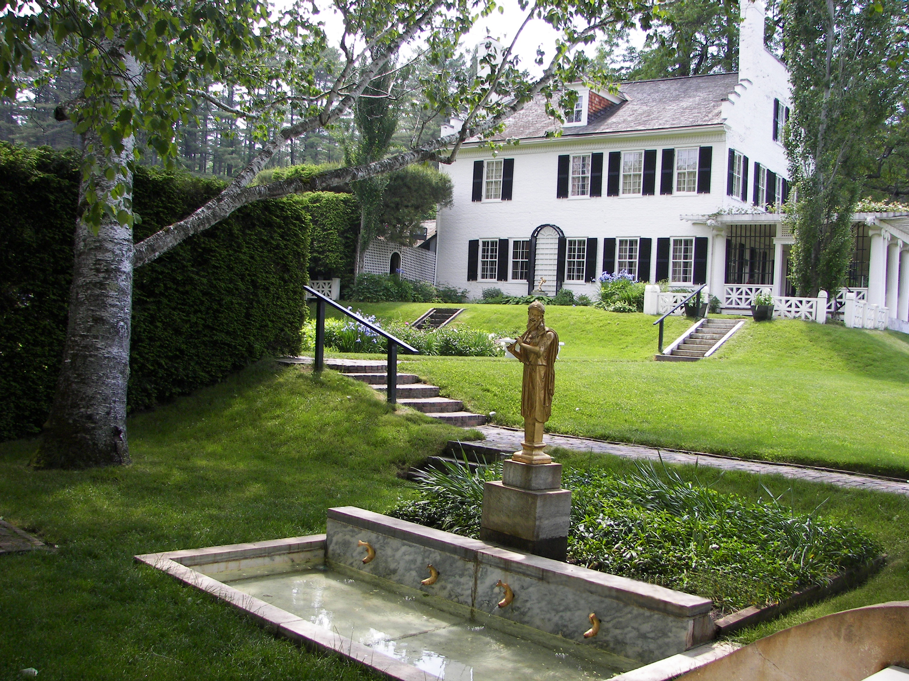
Saint-Gaudens National Historical Park
National Historical Park
Your National Park for the Arts preserves the home and studio of sculptor Augustus Saint-Gaudens (1848-1907). Here stories flow through a landscape of inspiration. Discover the history behind the capt...
Park data from the National Park Service API. Alerts update every 2 hours.
More Details
What kind of drive is this?
Expect a mixed driving experience that transitions from local roads to more structured highway segments. With a highway share of 48%, you will spend nearly half your time on faster-paced roads, while the remainder of the route keeps you on slower, secondary corridors. The longest uninterrupted stretch you will encounter is a 16.3-mile segment along the Franklin Pierce Highway. Because the route balances these two styles, the drive maintains a steady pace without becoming overly monotonous. You should anticipate a shift in road personality as you move off the local stretches and merge onto the Everett Turnpike for the final leg of your trip.
48% highway, the rest on surface roads — varied driving throughout.
20 navigation steps total — most of the decisions cluster near the start and finish.
Longest single stretch: 16.3 mi on Franklin Pierce Highway.
How Hard Is This Drive?
9/10
This route mixes highway mileage with some local-road sections near the start or finish. This route has several spots where lane changes, forks, or exits need your full attention. The trickiest moment comes around 15.6 miles in.
Driving Effort9/10
Demanding - stay alert through the decision-heavy sections
Balances navigation complexity with total wheel time.
This drive requires moderate attention. Across 80.5 miles you will encounter 13 spots where lane choice or exit timing matters. Not difficult for experienced highway drivers, but worth previewing the tricky sections before you go.
Where does it get tricky?
The main spots that need attention: at 15.6 miles: Exit ramp - move to the correct lane early. Multiple destination signs - pick the right one; at 65.8 miles: Exit ramp - move to the correct lane early. Multiple destination signs - pick the right one; at 72.1 miles (I 93 / Everett Turnpike): Highway fork - watch signs carefully. Lane positioning matters here.
Elevation Profile
Gently rolling terrain
1,426 ft254 ft
Total Climb
1,027 ft
Total Descent
1,172 ft
Highest Point
1,426 ft
~28.7 mi in
Elevation Range
1,172 ft
Towns Mentioned on Route Signs
Based on OSRM destination-sign hints, not a full list of every settlement the road passes.
Between Walpole, NH and Manchester, NH, road signs point toward Newport, Boston and Nashua.
Newport
15.6 mi in|~19m
Boston
65.8 mi in|~1h 29m
Nashua
74 mi in|~1h 39m|via I 293
Who Is This Route For?
Weekend Trip
Doable as a same-day drive at 1h 49m. Total distance: 80.5 miles.
Family Friendly
Moderate complexity with 0 natural rest stops along the way.
Solo Traveler
1h 49m drive, comfortable solo distance.
First-Time Driver
Mostly highway driving (48%). Some complex stretches to watch for.
Scenic Drive
Mixed highway & surface route profile with national parks nearby.
Frequently Asked Questions
The longest stretch is about 16.3 miles on Franklin Pierce Highway. The full list of main roads is in the Roads section above.
Expect about $0.88 in tolls one way, starting with Everett Turnpike. Most Northeast and Midwest toll agencies accept E-ZPass; in the West and Texas, transponders like TxTag or FasTrak apply. If you do not have a transponder, cashless tolling plates will mail a bill to the vehicle's registered address — usually with a surcharge, so a rental-car toll pass is often cheaper than paying by mail.
It helps. This route has a higher-than-average number of complex decision points, which get harder in the dark. If the last hour of the trip is on surface roads or mountain grades, aim to arrive at Manchester, NH before sunset when you can. Check the Trip Plan for departure windows that land you in daylight.
Yes. At under 2 hours behind the wheel, this works well for families — plan one quick stop if you have younger kids.
Mostly yes along the main roads, but rural stretches through NH can have sparse or no coverage. Before you leave, download offline Google Maps or Apple Maps for the route, and consider downloading music or podcasts instead of streaming. If you depend on data for navigation, keep a paper backup of the turn-by-turn directions.
The main spots that need attention: at 15.6 miles: Exit ramp - move to the correct lane early. Multiple destination signs - pick the right one; at 65.8 miles: Exit ramp - move to the correct lane early. Multiple destination signs - pick the right one; at 72.1 miles (I 93 / Everett Turnpike): Highway fork - watch signs carefully. Lane positioning matters here.
Yes — Saint-Gaudens National Historical Park. See the National Parks section for detour distances and tips on detours.
Yes. A round trip is manageable in a single day if you plan a break at Manchester, NH before heading back.