Origin
Tallahassee, FL
Morning in Tallahassee on Sunday
Local time
6:29 AM
EDT
Current temp
81°F
Unavailable
Live forecast
Compiled and reviewed by the US Trip Planner planning team at COD Solutions Oy · Last reviewed Apr 19, 2026 · Editorial standards
Drive Time
3h 28m
Distance
180.5 mi
290 km
Drive Score
8/10
Great drive
Same Day?
Yes, doable
Fuel Cost
$29
one way
EV Charging
Unknown
Estimated drive times based on typical traffic patterns. Actual times may vary with weather, construction, and real-time conditions.

Tallahassee, FL
Wikimedia Commons

Green Cove Springs, FL
Jose Valverde
Tallahassee, FL to Green Cove Springs, FL is 180.5 miles and takes about 3h 28m via I 10 and First Coast Expressway, with a fuel budget near $29 and enough daylight to finish in a day. This one-day drive primarily stays within Florida, taking you east across the state. Given its highway-focused profile and manageable duration, this route is a straightforward option for a quick trip. You'll spend most of your time on major interstates, making it a practical choice when time is a factor. Plan for a relatively efficient journey with minimal detours.
Trip Pace
Same-day drive is realistic
A same-day return is realistic if you keep stops short.
Break Rhythm
1 planned break
A short stop every 2 to 3 hours is enough for this drive.
Midpoint
90.2 miles from Tallahassee, FL
A natural place for your longest stop of the day , about 1h 44m into the drive .
| Road | Distance | Duration |
|---|---|---|
| I 10 | 140.4 mi | 2h 30m |
| First Coast Expressway | 25 mi | 28m |
| Mahan Drive | 6.5 mi | 11m |
| FL 16 | 5 mi | 8m |
| East Tennessee Street | 0.6 mi | 1m |
| South Franklin Boulevard | 0.5 mi | 1m |
| East Pensacola Street | 0.3 mi | <1m |
| South Monroe Street | <0.1 mi | <1m |
Step-by-step road directions between Tallahassee, FL and Green Cove Springs, FL.
Start on US 27; FL 61
Turn right onto East Pensacola Street
Turn left onto CR 1555
Turn right onto US 90
Continue on US 90
Take the ramp
Merge onto I 10
Take the exit
Keep slight right at fork
Merge onto FL 23 Toll
Take the exit
Keep slight left at fork
Turn straight onto FL 16
Turn right
Arrive at destination
With a drive of just over 3.5 hours, this trip is easily completed in a single day, allowing for flexibility in your departure time. Consider leaving in the morning to maximize daylight and take advantage of lighter traffic. The longest uninterrupted stretch is 140.4 miles on I 10, so plan your fuel and rest stops accordingly before embarking on this segment. While the fuel cost is estimated at $29, it's always wise to check current prices. Given the primarily highway nature, keep an eye out for official rest areas and service plazas along I 10 for convenient breaks.
Morning Departure
An early start around 7-8 AM gets you there with plenty of daylight left.
Evening Departure
A late afternoon start means arriving after dark. Morning is better.
This is a comfortable same-day trip.
Departure
Before you leave
Start with fuel, water, and navigation already sorted so the first hour feels easy.
First stop
Around 40 miles or 50m in
Use this first pause for coffee, a restroom break, and a quick traffic check ahead.
Halfway reset
Around 90.2 miles or 1h 44m in
This is the best place for your longest stop, a real meal, and a full fuel check.
Final approach
Final hour starts around 2h 45m
Traffic, exits, and arrival timing usually matter more near Green Cove Springs, FL than in the middle of the route.
Open the route before leaving Tallahassee, FL so your first major turns are already loaded.
Leave with enough water and a charging cable within reach, not packed away.
Check your fuel range against the first long segment, especially if you are starting outside city service areas.
Day 1
Settle into the route from Tallahassee, FL
This is one driving day of about 180.5 miles and 3h 28m.
Rest stops, refuel points, and overnight suggestions along this route.

Mid-route town
Meal stop
90 mi into the route
Best for: Lunch, fuel, and a longer reset
This sits close to the middle of the route, so it works well for the longest stop of the day.
A short stop after about 40 miles helps settle the day before fatigue starts building.
The midpoint is around 90.2 miles from Tallahassee, FL, which is a good place for a longer meal and fuel stop.
Before the longest stretch
Fuel checkTop up before I 10 if your tank is already low. That segment runs about 140.4 miles.
These stop ideas are pacing suggestions — the exact town or exit can change with traffic, hotel plans, and fuel range.
5 decision points cluster between mile 0 and 175.3 — GPS handles the exact turns, but know they're coming. Your lane choice matters more than the turn itself.
Turn right onto East Pensacola Street
Navigation decision point
Take the exit toward FL 23 North, FL 23 Toll South: Cecil Commerce Center Parkway, Beaver Street
Exit ramp - move to the correct lane early. Lane positioning matters here. Multiple destination signs - pick the right one
Keep slight right at fork toward FL 23 Toll South: Cecil Commerce Center Parkway, First Coast Expressway South
Highway fork - watch signs carefully. Multiple destination signs - pick the right one
Take the exit toward FL 16: Green Cove Springs, Penney Farms
Exit ramp - move to the correct lane early. Multiple destination signs - pick the right one
Keep slight left at fork toward FL 16 East: Green Cove Springs
Highway fork - watch signs carefully. Lane positioning matters here
Regular Gas
$28.73 one way
$57.46 round trip
| Fuel Type | $/gal | One Way | Round Trip |
|---|---|---|---|
| midgrade | $4.40 | $31.25 | $62.51 |
| premium | $4.72 | $33.56 | $67.13 |
| diesel | $5.61 | $39.85 | $79.70 |
No toll roads detected on this route.
Estimated Trip Cost (one way, 1 person)
Fuel
$29
Meals
$25–$50
Total
$54–$79
Rough estimate based on US averages. Hotel $80–$140/night, meals $25–$50/day.
Estimated CO2 emission: 63.2 kg one way. Prices: EIA weekly data, 2026-04-13.
Driving Electric?
About $19 in charging · 0 stops · 67% less CO2
| Vehicle Type | kWh | Stops | DC Fast | Home Charge |
|---|---|---|---|---|
| Average EV | 54.2 | 0 | $18.95 | $8.66 |
| Efficient EV | 45.1 | 0 | $15.79 | $7.22 |
| EV Truck/SUV | 72.2 | 0 | $25.27 | $11.55 |
Gas CO2
63 kg
EV CO2
21 kg (67% less)
This trip is well within single-charge range for most EVs. No charging stops needed if you start fully charged.
DC fast charging avg $0.35/kWh. Home charging avg $0.16/kWh. US grid CO2: 0.39 kg/kWh.
Current conditions at both ends of the drive.
Origin
Morning in Tallahassee on Sunday
Local time
6:29 AM
EDT
Current temp
81°F
Unavailable
Destination
Morning in Green Cove Springs on Sunday
Local time
6:29 AM
EDT
Current temp
58°F
Unavailable
Seasonal Notes
Summer travel usually means heavier construction, hotter rest stops, and busier weekend traffic around major cities.
Winter travel shortens daylight, so a route that looks manageable on paper can feel much longer after dark.
Holiday weekends tend to make both departure and arrival windows slower than the raw route time suggests.
Time zone
Origin and destination are on the same clock, so arrival timing is easier to judge at a glance.
Temperature spread
A meaningful temperature swing is a good cue to rethink layers, water, and how soon you want to arrive.
Road read
Use the two city cards together: check the sky where you start, then compare it with the local time and temperature at arrival.
Weather data from the National Weather Service. Conditions may change; check closer to your travel date.
Worth a detour if your schedule allows.
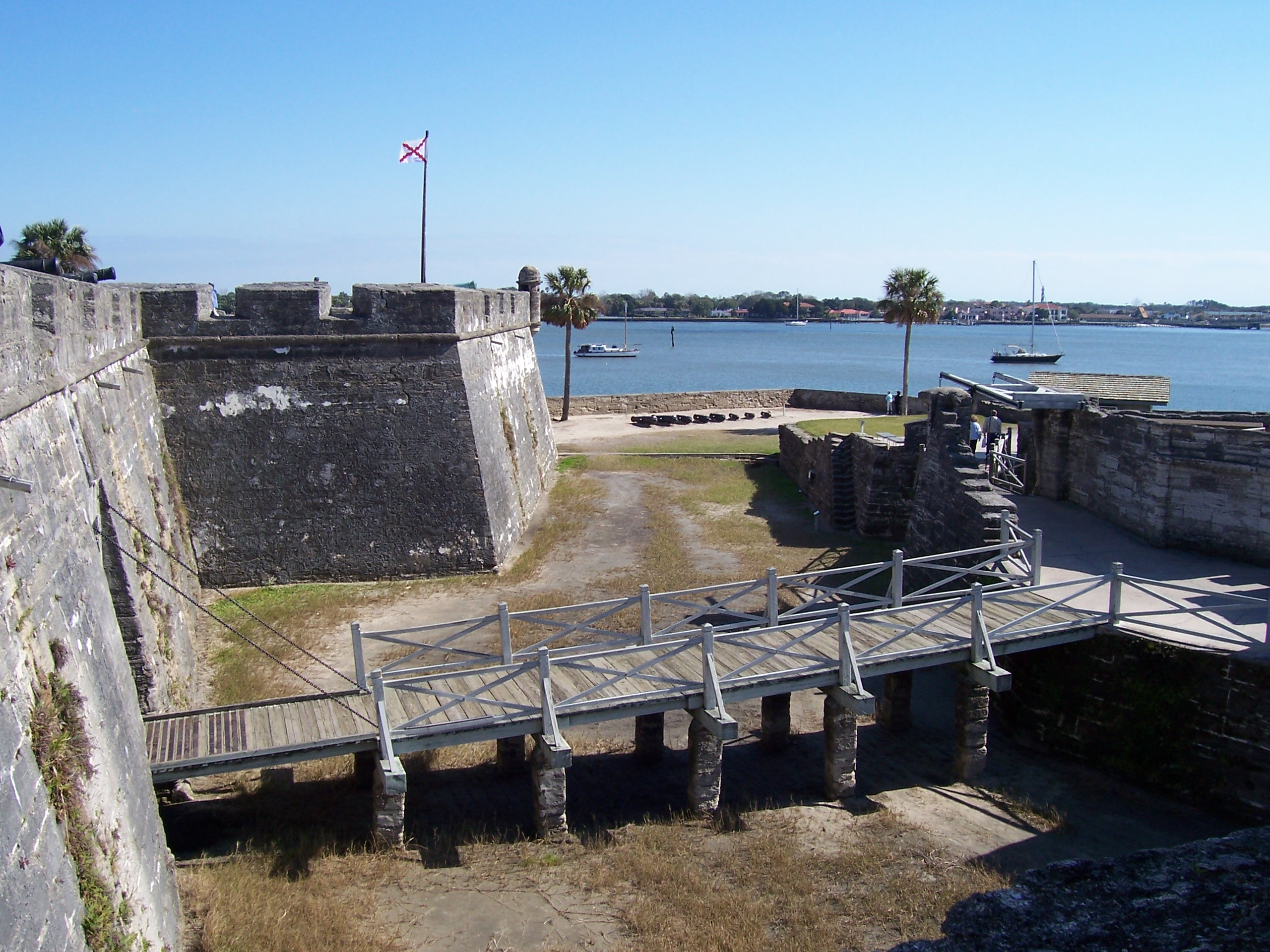
National Monument
Built by the Spanish in St. Augustine to defend Florida and the Atlantic trade route, Castillo de San Marcos National Monument preserves the oldest masonry fortification in the continental United Stat...
Park data from the National Park Service API. Alerts update every 2 hours.
This drive is overwhelmingly highway-focused, with a 94% highway share. Expect to spend the majority of your time on I 10, which forms the backbone of this journey for a significant 140.4 miles. This long stretch on I 10 suggests a consistent pace and minimal interruptions for the bulk of the trip. As you approach your destination, the route incorporates the First Coast Expressway, offering a modern highway experience. Mahan Drive also plays a role, likely serving as an approach or exit route in the Tallahassee area. Overall, it's a predominantly high-speed transit experience.
This is a straightforward highway drive that stays mostly on I 10 and First Coast Expressway. You will hit about 10 points where you need to pay attention to lane position or signs. The trickiest moment comes early in the drive near East Pensacola Street.
Moderate - straightforward overall, but long enough or busy enough to require pacing
Balances navigation complexity with total wheel time.
This drive requires moderate attention. Across 180.5 miles you will encounter 10 spots where lane choice or exit timing matters. Not difficult for experienced highway drivers, but worth previewing the tricky sections before you go.
Where does it get tricky?
The main spots that need attention: near the start (East Pensacola Street): Navigation decision point; at 148.9 miles: Exit ramp - move to the correct lane early. Lane positioning matters here. Multiple destination signs - pick the right one; at 149.1 miles: Highway fork - watch signs carefully. Multiple destination signs - pick the right one.
Based on OSRM destination-sign hints, not a full list of every settlement the road passes.
On the drive from Tallahassee, FL to Green Cove Springs, FL, road signs begin pointing toward First Coast Expressway South along the way.
First Coast Expressway South
Tallahassee is the capital city of Florida, in the Florida Panhandle region of the state. In addition to housing the state government, it is a university town home to Florida State University, Florida A&M University, and Tallahassee Community College. Tallahassee has a good selection of restaurants for a city of its size. The universities' theater, art, and music programs, in addition to an active Council of Culture and Arts, also make for an unusually vibrant arts scene.
City content from Wikivoyage (CC BY-SA 4.0) and Wikidata (CC0).
Weekend Trip
Doable as a same-day drive at 3h 28m. Total distance: 180.5 miles.
Family Friendly
Moderate complexity with 1 natural rest stops along the way.
Solo Traveler
3h 28m drive, comfortable solo distance.
First-Time Driver
Mostly highway driving (94%). Some complex stretches to watch for.
Compiled by the US Trip Planner planning team at COD Solutions Oy from open government datasets — OSRM over OpenStreetMap for geometry, EIA for fuel prices, and NPS for national parks. See our methodology for refresh cadence and limitations.
Was this helpful?
Thanks for your feedback!
Your tip has been submitted. Thanks!
/500
Recent Tips
·
Explore more options from Tallahassee, FL or browse trips ending in Green Cove Springs, FL.
Looking for more statewide routes? Browse FL road trips.