Origin
Stewartville, AL
Late night in Stewartville on Sunday
Local time
3:11 AM
CDT
Current temp
78°F
Unavailable
Live forecast
Compiled and reviewed by the US Trip Planner planning team at COD Solutions Oy · Last reviewed Apr 19, 2026 · Editorial standards
Drive Time
2h 44m
Distance
132.9 mi
214 km
Drive Score
8/10
Great drive
Same Day?
Yes, doable
Fuel Cost
$20
one way
EV Charging
Unknown
Estimated drive times based on typical traffic patterns. Actual times may vary with weather, construction, and real-time conditions.

Stewartville, AL
Muhammad Nabeel

Decatur, AL
Wikimedia Commons
Stewartville to Decatur is 132.9 miles and takes about 2h 44m via I 65 and US 280, with a fuel budget near $20 and enough daylight to finish in a day. This one-day trip takes you through the Southeast region of Alabama, primarily on highway roads. You'll spend most of your time on well-maintained interstates and US highways, making for a straightforward journey. This route is ideal if you're looking for an efficient drive between these two Alabama locations without extensive detours. Consider this trip for a quick transition between areas.
Trip Pace
Same-day drive is realistic
A same-day return is realistic if you keep stops short.
Break Rhythm
1 planned break
A short stop every 2 to 3 hours is enough for this drive.
Midpoint
66.5 miles from Stewartville, AL
A natural place for your longest stop of the day , about 1h 26m into the drive .
| Road | Distance | Duration |
|---|---|---|
| I 65 | 70.7 mi | 1h 16m |
| US 280 | 26.1 mi | 35m |
| US 231 | 18.1 mi | 24m |
| Point Mallard Parkway Southeast | 4.5 mi | 6m |
| Broadway Avenue | 4.4 mi | 4m |
| 6th Avenue Southeast | 3 mi | 5m |
| Red Mountain Expressway | 2.9 mi | 3m |
| Carraway Boulevard | 1.5 mi | 3m |
Step-by-step road directions between Stewartville, AL and Decatur, AL.
Start on County Road 41
Turn right onto US 231; AL 21
Continue on US 231; AL 21
Turn left onto US 231
Continue on US 280
Take the exit onto US 280
Merge onto US 31; US 280
Continue on US 31
Turn left onto AL 378
Turn right onto 19th Street North
Take the ramp
Merge onto I 65
Take the exit
Turn left onto AL 67
Turn right onto US 31
Continue on US 31
Turn left onto Lee Street Northeast
Turn right
Arrive at destination
Given the 2h 44m duration, starting your trip in Stewartville in the morning is recommended to allow for a full day at your destination in Decatur. With only one recommended stop and a fuel cost around $20, this is a manageable drive for a single day. Pay attention to signage for the transition from I 65 to US 280, as this is a key point in navigating the route efficiently. Ensure your fuel tank is adequately filled before departing Stewartville, as the longest stretch on I 65 is over 70 miles.
Morning Departure
Leave by 9 AM and you'll arrive before lunch.
Evening Departure
Even a 4 PM departure gets you there before dark in summer.
This is a comfortable same-day trip.
Departure
Before you leave
Start with fuel, water, and navigation already sorted so the first hour feels easy.
First stop
Around 29 miles or 38m in
Use this first pause for coffee, a restroom break, and a quick traffic check ahead.
Halfway reset
Around 66.5 miles or 1h 26m in
This is the best place for your longest stop, a real meal, and a full fuel check.
Final approach
Final hour starts around 2h 12m
Traffic, exits, and arrival timing usually matter more near Decatur, AL than in the middle of the route.
Open the route before leaving Stewartville, AL so your first major turns are already loaded.
Leave with enough water and a charging cable within reach, not packed away.
Check your fuel range against the first long segment, especially if you are starting outside city service areas.
Day 1
Settle into the route from Stewartville, AL
This is one driving day of about 132.9 miles and 2h 44m.
Rest stops, refuel points, and overnight suggestions along this route.

Mid-route town
Meal stop
66 mi into the route
Best for: Lunch, fuel, and a longer reset
This sits close to the middle of the route, so it works well for the longest stop of the day.
A short stop after about 29 miles helps settle the day before fatigue starts building.
The midpoint is around 66.5 miles from Stewartville, AL, which is a good place for a longer meal and fuel stop.
Before the longest stretch
Fuel checkTop up before I 65 if your tank is already low. That segment runs about 70.7 miles.
These stop ideas are pacing suggestions — the exact town or exit can change with traffic, hotel plans, and fuel range.
5 decision points cluster between mile 48.5 and 129.6 — GPS handles the exact turns, but know they're coming. Your lane choice matters more than the turn itself.
Take the exit onto US 280 toward US 31 North, US 280 West: Birmingham
Exit ramp - move to the correct lane early. Multiple destination signs - pick the right one
Merge onto US 31; US 280 / Red Mountain Expressway
Merge point - match speed before joining. Lane positioning matters here
Merge onto I 65
Merge point - match speed before joining. Lane positioning matters here
Take the exit toward 67: Decatur, Priceville, Somerville
Exit ramp - move to the correct lane early. Multiple destination signs - pick the right one
Turn right onto US 31 / 6th Avenue Southeast
Lane positioning matters here
Regular Gas
$20.07 one way
$40.14 round trip
| Fuel Type | $/gal | One Way | Round Trip |
|---|---|---|---|
| midgrade | $4.21 | $22.03 | $44.07 |
| premium | $4.56 | $23.85 | $47.71 |
| diesel | $5.61 | $29.34 | $58.69 |
No toll roads detected on this route.
Estimated Trip Cost (one way, 1 person)
Fuel
$20
Meals
$25–$50
Total
$45–$70
Rough estimate based on US averages. Hotel $80–$140/night, meals $25–$50/day.
Estimated CO2 emission: 46.5 kg one way. Prices: EIA weekly data, 2026-04-13.
Driving Electric?
About $14 in charging · 0 stops · 65% less CO2
| Vehicle Type | kWh | Stops | DC Fast | Home Charge |
|---|---|---|---|---|
| Average EV | 39.9 | 0 | $13.95 | $6.38 |
| Efficient EV | 33.2 | 0 | $11.63 | $5.32 |
| EV Truck/SUV | 53.2 | 0 | $18.61 | $8.51 |
Gas CO2
46 kg
EV CO2
16 kg (65% less)
This trip is well within single-charge range for most EVs. No charging stops needed if you start fully charged.
DC fast charging avg $0.35/kWh. Home charging avg $0.16/kWh. US grid CO2: 0.39 kg/kWh.
Current conditions at both ends of the drive.
Origin
Late night in Stewartville on Sunday
Local time
3:11 AM
CDT
Current temp
78°F
Unavailable
Destination
Late night in Decatur on Sunday
Local time
3:11 AM
CDT
Current temp
78°F
Unavailable
49°F
Birmingham, AL
66 mi in
Seasonal Notes
Summer travel usually means heavier construction, hotter rest stops, and busier weekend traffic around major cities.
Winter travel shortens daylight, so a route that looks manageable on paper can feel much longer after dark.
Holiday weekends tend to make both departure and arrival windows slower than the raw route time suggests.
Time zone
Origin and destination are on the same clock, so arrival timing is easier to judge at a glance.
Temperature spread
Both ends of the route are sitting at about the same temperature right now.
Road read
Use the two city cards together: check the sky where you start, then compare it with the local time and temperature at arrival.
Weather data from the National Weather Service. Conditions may change; check closer to your travel date.
Worth a detour if your schedule allows.
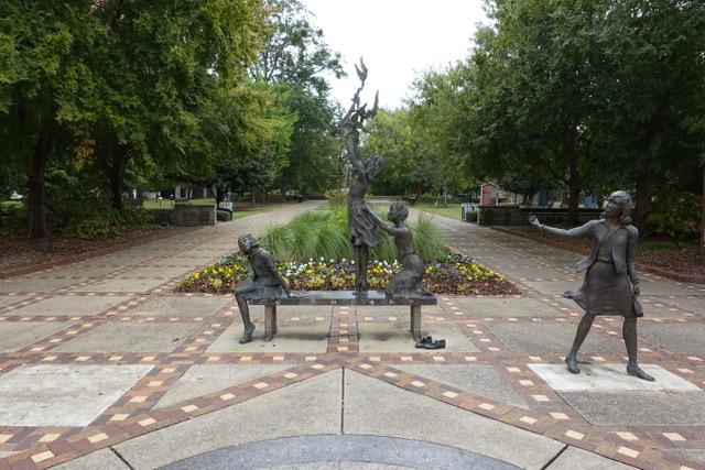
National Monument
In 1963, images of snarling police dogs unleashed against non-violent protesters and of children being sprayed with high-pressure hoses appeared in print and television news around the world. These dr...
Park data from the National Park Service API. Alerts update every 2 hours.
This drive is predominantly highway-focused, with 92% of the journey on major roads like I 65 and US 280. Expect a consistent pace for much of the trip, particularly during the longest stretch of 70.7 miles on I 65. While the majority is interstate, you'll also navigate sections of US 231, offering a slight variation in the driving experience. The highway character means you'll likely encounter higher speed limits and fewer local traffic interruptions for extended periods.
This is a straightforward highway drive that stays mostly on I 65 and US 280. You will hit about 13 points where you need to pay attention to lane position or signs. The trickiest moment comes around 48.5 miles in near US 280.
Moderate - straightforward overall, but long enough or busy enough to require pacing
Balances navigation complexity with total wheel time.
This drive requires moderate attention. Across 132.9 miles you will encounter 13 spots where lane choice or exit timing matters. Not difficult for experienced highway drivers, but worth previewing the tricky sections before you go.
Where does it get tricky?
The main spots that need attention: at 48.5 miles (US 280): Exit ramp - move to the correct lane early. Multiple destination signs - pick the right one; at 48.9 miles (US 31; US 280 / Red Mountain Expressway): Merge point - match speed before joining. Lane positioning matters here; at 54.1 miles (I 65): Merge point - match speed before joining. Lane positioning matters here.
Based on OSRM destination-sign hints, not a full list of every settlement the road passes.
Between Stewartville, AL and Decatur, AL, road signs point toward 67: Decatur, Priceville and Somerville.
67: Decatur
Priceville
Somerville
Weekend Trip
Doable as a same-day drive at 2h 44m. Total distance: 132.9 miles.
Family Friendly
Moderate complexity with 1 natural rest stops along the way.
Solo Traveler
2h 44m drive, comfortable solo distance.
First-Time Driver
Mostly highway driving (92%). Some complex stretches to watch for.
Compiled by the US Trip Planner planning team at COD Solutions Oy from open government datasets — OSRM over OpenStreetMap for geometry, EIA for fuel prices, and NPS for national parks. See our methodology for refresh cadence and limitations.
Was this helpful?
Thanks for your feedback!
Your tip has been submitted. Thanks!
/500
Recent Tips
·
Explore more options from Stewartville, AL or browse trips ending in Decatur, AL.
Looking for more statewide routes? Browse AL road trips.