Spanning 396.2 miles across Oregon, your journey from Stanfield to Medford takes approximately 8 hours and 42 minutes of pure driving time. Given the length and the technical nature of the roads, you should plan for a two-day trip rather than attempting it in a single push. You will navigate via the Dalles-California Highway, the Sherman Highway, and the Columbia River Highway. Budget roughly $79 for fuel to complete this trek between these two Pacific Coast region points. While the route offers a direct path, the turn-heavy local segments make it a demanding drive that requires your full attention behind the wheel.
Trip Pace
Best split across 2 days
Treat the return leg as its own travel day rather than an afterthought.
Break Rhythm
2 planned breaks
Plan on a short reset every 3 to 4 hours to stay fresh behind the wheel.
Midpoint
198.1 miles from Stanfield, OR
A natural place for your longest stop of the day
, about 4h 2m into the drive
.
Main Roads
Road
Distance
Duration
The Dalles-California Highway
121.9 mi
2h 35m
Sherman Highway
67.7 mi
1h 29m
Columbia River Highway
62.9 mi
1h 7m
Crater Lake Highway
49.9 mi
1h 12m
Diamond Lake Highway
23.8 mi
35m
Old Oregon Trail Highway
20.9 mi
22m
East Diamond Lake Highway
8.4 mi
11m
Old Bend Redmond Highway
6.6 mi
11m
Longest stretch:
The Dalles-California Highway
— 121.9 mi, about 2h 35m
Traffic on I-84
Hour-of-day weekday pattern from 12 FHWA count stations on your route.
Peak
2 PM
~656 veh/hr typical
· worst 1,220
Quietest
2 AM
~71 veh/hr
Peak-to-quiet ratio
9.2×
busier at peak than in the quiet hours
12a6anoon6p11p
Averaged across 52 weeks of 2023 FHWA Travel Monitoring Analysis System data. Weekday hours only (Mon–Fri).
Turn-by-Turn Driving Directions
Step-by-step road directions between Stanfield, OR and Medford, OR.
1
Start on this road
52 ft·9 sec·this road
2
Turn left onto East Coe Avenue
114 ft·8 sec·East Coe Avenue
3
Turn left onto US 395
0.2 mi·15 sec·South Main Street
4
Continue on US 395
1.2 mi·1 min·Umatilla-Stanfield Highway
5
Take the exit
0.2 mi·27 sec
Toward I 84 West, US 30 West: Portland
6
Merge onto I 84; US 30
21 mi·22 min·Old Oregon Trail Highway
7
Continue on I 84; US 30
63 mi·1 hr 7 min·Columbia River Highway
8
Take the exit
0.2 mi·37 sec
Toward US 97: Yakima, Bend
9
Turn left onto US 97
55 mi·1 hr 12 min·Sherman Highway
10
Continue on US 97
0.4 mi·52 sec·E Street
11
Turn straight onto US 97
12 mi·16 min·Sherman Highway
12
Continue on US 97
25 mi·29 min·The Dalles-California Highway
13
Continue on US 97
0.2 mi·32 sec·Northeast 6th Street
14
Turn left onto US 26; US 97
264 ft·12 sec·4th Street
Use the left / straight / right lanes.
15
Continue on US 26; US 97
1.0 mi·3 min·Southwest 4th Street
16
Continue on US 26; US 97
26 mi·37 min·The Dalles-California Highway
17
Turn right onto US 97 Business
503 ft·14 sec·Southwest Veterans Way
18
Turn left onto Southwest Canal Boulevard
0.3 mi·47 sec·Southwest Canal Boulevard
Use the left lane.
19
Enter roundabout onto Southwest Canal Boulevard
60 ft·1 sec·Southwest Canal Boulevard
20
Continue on Southwest Canal Boulevard
1.4 mi·3 min·Southwest Canal Boulevard
21
Enter roundabout onto Southwest Canal Boulevard
112 ft·2 sec·Southwest Canal Boulevard
22
Continue on Southwest Canal Boulevard
0.8 mi·1 min·Southwest Canal Boulevard
23
Enter roundabout onto Southwest Canal Boulevard
125 ft·2 sec·Southwest Canal Boulevard
24
Continue on Southwest Canal Boulevard
3.8 mi·6 min·Southwest Canal Boulevard
25
Continue on Old Bend Redmond Highway
3.5 mi·6 min·Old Bend Redmond Highway
26
Enter roundabout onto Old Bend Redmond Highway
121 ft·2 sec·Old Bend Redmond Highway
27
Continue on Old Bend Redmond Highway
3.1 mi·5 min·Old Bend Redmond Highway
28
Enter roundabout onto US 20
276 ft·3 sec·McKenzie-Bend Highway
29
Continue on US 20
0.7 mi·1 min·McKenzie-Bend Highway
30
Enter roundabout onto US 20
130 ft·1 sec·McKenzie-Bend Highway
31
Continue on US 20
0.4 mi·36 sec·McKenzie-Bend Highway
32
Enter roundabout onto US 20
118 ft·1 sec·McKenzie-Bend Highway
33
Continue on US 20
0.8 mi·57 sec·McKenzie-Bend Highway
34
Turn straight onto US 20; US 97 Business
439 ft·13 sec·Northeast 3rd Street
35
Turn left onto Empire Avenue
0.2 mi·20 sec·Empire Avenue
36
Take the exit
0.3 mi·32 sec
37
Merge onto US 97
5.5 mi·9 min·Bend Parkway
Use the straight / slight right lanes.
38
Continue on US 97
71 mi·1 hr 28 min·The Dalles-California Highway
39
Turn right onto OR 138
6.3 mi·8 min·State Highway 138
40
Continue on OR 138
8.4 mi·11 min·East Diamond Lake Highway
41
Continue on OR 138
3.0 mi·4 min·North Umpqua Highway
42
Turn left onto OR 230
24 mi·35 min·Diamond Lake Highway
43
Continue on Crater Lake Highway
50 mi·1 hr 11 min·Crater Lake Highway
Use the straight lane.
44
Turn right onto OR 62
4.4 mi·6 min·Rogue Valley Expressway
45
Continue on OR 62
0.4 mi·39 sec·Crater Lake Highway
46
Turn left onto Poplar Drive
0.9 mi·1 min·Poplar Drive
Use the left lane.
47
Turn right onto East McAndrews Road
0.2 mi·20 sec·East McAndrews Road
48
Turn left onto Biddle Road
512 ft·18 sec·Biddle Road
Use the left / straight lanes.
49
Keep slight right at fork onto Biddle Road
0.1 mi·13 sec·Biddle Road
50
Keep slight right at fork onto Biddle Road
0.2 mi·21 sec·Biddle Road
51
Keep slight right at fork onto Biddle Road
0.3 mi·29 sec·Biddle Road
52
Continue on East 4th Street
0.4 mi·56 sec·East 4th Street
Use the straight / right lanes.
53
Turn left onto North Fir Street
0.1 mi·15 sec·North Fir Street
54
Arrive at destination
North Fir Street
Trip Plan
To make the most of this 396.2-mile journey, prioritize a two-day itinerary to avoid fatigue on the more technical sections. Plan for at least 2 distinct stops to stretch your legs and manage your fuel consumption, especially since the local roads can be harder on your vehicle than standard highways. Since this is a turn-heavy drive, starting early in the morning is essential to ensure you navigate the most challenging segments during daylight hours. Keep a close eye on your fuel gauge throughout the trip, as the $79 estimated cost can fluctuate depending on your vehicle's performance on the winding terrain. Use the long 121.9-mile stretch on the Dalles-California Highway to gauge your pace and decide where your overnight rest stop should fall.
Morning Departure
Start early — leave by 6-7 AM to arrive at a reasonable hour.
Evening Departure
This is a long drive — plan for a morning departure or consider splitting it into two days.
This drive is better paced as a 2-day trip.
Plan roughly 2 meaningful breaks for fuel, food, and rest.
The halfway point lands around 198.1 miles from Stanfield, OR, or about 4h 2m into the drive.
The longest continuous stretch on this route runs about 121.9 miles.
Consider an overnight stop or starting very early.
Departure
Before you leave
Start with fuel, water, and navigation already sorted so the first hour feels easy.
First stop
Around 87 miles or 1h 34m in
Use this first pause for coffee, a restroom break, and a quick traffic check ahead.
Halfway reset
Around 198.1 miles or 4h 2m in
This is the best place for your longest stop, a real meal, and a full fuel check.
Overnight split
Day 1 wrap after about 198.1 miles or 4h 2m
Stop before fatigue turns the last few hours into a grind. You want day two to start fresh, not just resumed.
Final approach
Final hour starts around 7h 14m
Traffic, exits, and arrival timing usually matter more near Medford, OR than in the middle of the route.
Before You Leave
+
Open the route before leaving Stanfield, OR so your first major turns are already loaded.
+
Leave with enough water and a charging cable within reach, not packed away.
+
Check your fuel range against the first long segment, especially if you are starting outside city service areas.
+
Pick one backup stop option before the midpoint in case traffic changes your pacing.
+
Treat this as a 2-day road trip and book the overnight stop before the busiest arrival window.
Day 1
Settle into the route from Stanfield, OR
Aim for roughly 198 miles and 4.4 hours of wheel time on this day.
Day 2
Finish the approach into Medford, OR
Aim for roughly 198 miles and 4.4 hours of wheel time on this day.
Your first comfortable stop window is around 87 miles from Stanfield, OR.
This route usually feels better as a 2-day drive than as one long push.
Plan about 2 real breaks rather than only quick fuel stops.
The longest stretch is on The Dalles-California Highway for about 121.9 miles.
Where to Stop
Rest stops, refuel points, and overnight suggestions along this route.
Place data sourced from public business listings. Hours and availability may vary.
Heads-up: tricky spots
5 of 28
5 decision points cluster between mile 0 and 206.3 — GPS handles the exact turns, but know they're coming. Your lane choice matters more than the turn itself.
5
0 mi into trip|~0m in|East Coe Avenue
Turn left onto East Coe Avenue
Navigation decision point
5
0 mi into trip|~0m in|US 395 / South Main Street
Turn left onto US 395 / South Main Street
Navigation decision point
6
1.5 mi into trip|~1m in
Take the exit toward I 84 West, US 30 West: Portland
Exit ramp - move to the correct lane early. Multiple destination signs - pick the right one
Toward I 84 West, US 30 West: Portland
5
85.5 mi into trip|~1h 32m in
Take the exit toward US 97: Yakima, Bend
Exit ramp - move to the correct lane early. Multiple destination signs - pick the right one
Toward US 97: Yakima, Bend
6
206.3 mi into trip|~4h 14m in|Southwest Canal Boulevard
Enter roundabout onto Southwest Canal Boulevard
Roundabout - know your exit number before entering
Fuel & Cost
Regular Gas
$70.21 one way
$140.42 round trip
$4.50/gal25.4 MPG avg139 kg CO2
Fuel Type
$/gal
One Way
Round Trip
midgrade
$4.82
$75.18
$150.37
premium
$5.04
$78.65
$157.29
diesel
$4.80
$74.81
$149.62
No toll roads detected on this route.
Estimated Trip Cost (one way, 1 person)
Fuel
$70
Hotel (1n)
$80–$140
Meals
$50–$100
Total
$200–$310
Rough estimate based on US averages. Hotel $80–$140/night, meals $25–$50/day.
Estimated CO2 emission: 138.6 kg one way.
Prices: EIA weekly data, 2026-07-13.
Driving Electric?
About $42 in charging
· 1 stop
· 67% less CO2
Vehicle Type
kWh
Stops
DC Fast
Home Charge
Average EV
118.9
1
$41.60
$19.02
Efficient EV
99.1
1
$34.67
$15.85
EV Truck/SUV
158.5
1
$55.47
$25.36
Gas CO2
139 kg
EV CO2
46 kg (67% less)
Plan for 1 charging stop. A 30-minute DC fast charge mid-route should be enough to complete the trip comfortably.
DC fast charging avg $0.35/kWh. Home charging avg $0.16/kWh. US grid CO2: 0.39 kg/kWh.
Travel Intel
Current conditions at both ends of the drive.
Forecast as of Jul 17, 2026
Origin
Stanfield, OR
Evening
in Stanfield on Saturday
Local time
7:51 PM
PDT
Current temp
59°F
Mostly Clear
SW 8 to 17 mph2% chanceLive forecast
Wind Advisory
Wind Advisory issued July 16 at 8:44PM PDT until July 17 at 1:00AM PDT by NWS Pendleton OR
Wind Advisory
Wind Advisory issued July 16 at 8:44PM PDT until July 17 at 1:00AM PDT by NWS Pendleton OR
Destination
Medford, OR
Evening
in Medford on Saturday
Local time
7:51 PM
PDT
Current temp
54°F
Clear
WNW 0 to 12 mph0% chanceLive forecast
Wind Advisory
Wind Advisory issued July 16 at 8:44PM PDT until July 17 at 1:00AM PDT by NWS Pendleton OR
Wind Advisory
Wind Advisory issued July 16 at 8:44PM PDT until July 17 at 1:00AM PDT by NWS Pendleton OR
Seasonal Notes
Summer travel usually means heavier construction, hotter rest stops, and busier weekend traffic around major cities.
Winter travel shortens daylight, so a route that looks manageable on paper can feel much longer after dark.
Holiday weekends tend to make both departure and arrival windows slower than the raw route time suggests.
For long drives, weather on day two can matter just as much as conditions at departure, so check the whole travel window rather than only the first day.
Time zone
Same local time
Origin and destination are on the same clock, so arrival timing is easier to judge at a glance.
Temperature spread
5 degrees cooler at arrival
A meaningful temperature swing is a good cue to rethink layers, water, and how soon you want to arrive.
Road read
8h 42m on the road
This is long enough that the arrival forecast matters almost as much as departure conditions. Recheck both ends before you roll.
Weather data from the National Weather Service. Conditions may change; check closer to your travel date.
National Parks Near This Route
Worth a detour if your schedule allows.
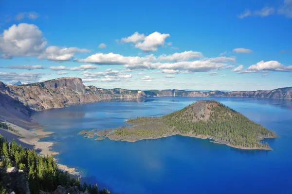
Crater Lake National Park
National Park
Crater Lake inspires awe. Native Americans witnessed its formation 7,700 years ago, when a violent eruption triggered the collapse of a tall peak. Scientists marvel at its purity—fed by rain and snow,...
11 mi from route
~28 min detour
$30
near mile 314.2
Park data from the National Park Service API. Alerts update every 2 hours.
More Details
What kind of drive is this?
Expect a trip defined by its technical layout rather than a straightforward interstate cruise, as this route maintains only a 4% highway share. You will spend the bulk of your time navigating winding local roads that demand frequent gear shifts and careful steering. Your longest uninterrupted stretch covers 121.9 miles on the Dalles-California Highway, providing a brief reprieve from the constant turns. This profile creates a drive that changes rhythm significantly as you transition between major segments. Prepare for a hands-on experience where the focus is on managing the curves and elevation changes rather than cruising at high speeds.
Only 4% highway — the rest is turn-by-turn surface driving.
54 navigation steps total — most of the decisions cluster near the start and finish.
Longest single stretch: 121.9 mi on The Dalles-California Highway.
How Hard Is This Drive?
9/10
Expect a hands-on drive with frequent turns and local roads rather than long highway stretches. This route has several spots where lane changes, forks, or exits need your full attention. The trickiest moment comes early in the drive near East Coe Avenue.
Driving Effort9/10
High effort - long or complex enough to need steady focus all day
Balances navigation complexity with total wheel time.
This is a demanding drive. With 28 significant decision points across 396.2 miles, you will need to stay alert - especially through interchange areas and urban stretches. Consider splitting it into segments if you are not comfortable with fast highway navigation.
Where does it get tricky?
The main spots that need attention: near the start (East Coe Avenue): Navigation decision point; near the start (US 395 / South Main Street): Navigation decision point; at 1.5 miles: Exit ramp - move to the correct lane early. Multiple destination signs - pick the right one.
Elevation Profile
High-altitude sections with notable climbs
5,894 ft184 ft
Total Climb
7,233 ft
Total Descent
6,445 ft
Highest Point
5,894 ft
~311.3 mi in
Elevation Range
5,710 ft
Notable High Points
3,349 ft at ~141.5 miles+1,090 ft prominence
5,894 ft at ~311.3 miles+1,160 ft prominence
Towns Mentioned on Route Signs
Based on OSRM destination-sign hints, not a full list of every settlement the road passes.
On the drive from Stanfield, OR to Medford, OR, road signs begin pointing toward Bend along the way.
Medford is a city in the Rogue Valley in Southern Oregon. The town is southern Oregon's largest and most diverse city, brimming with historical and cultural attractions while offering regional tax-free shopping. Medford is the county seat of Jackson County, and is the commercial and medical hub of southern Oregon. Its autumns tend to be very mild, and dry when compared to the rest of the state.
Top landmarks
•Barnum Hotel — historic hotel building in Medford, Oregon, USA
•Jackson County Courthouse — historic building in Medford, Oregon, United States
•James A. Redden Federal Courthouse — courthouse in Medford, Oregon, USA
Mostly surface roads route profile with national parks nearby.
Frequently Asked Questions
The longest stretch is about 121.9 miles on The Dalles-California Highway. The full list of main roads is in the Roads section above.
Yes — a 2-day pace is more comfortable than one long haul. A sensible stopping point is after roughly 198 miles on day one.
Yes — we found about 17 rest areas or service plazas within a short detour of the route (from OpenStreetMap). See the Rest Stops tab under Nearby Places for locations and mile markers. Plan to stretch, use the bathroom, and top off fluids every 2–3 hours on longer drives.
It helps. This route has a higher-than-average number of complex decision points, which get harder in the dark. If the last hour of the trip is on surface roads or mountain grades, aim to arrive at Medford, OR before sunset when you can. Check the Trip Plan for departure windows that land you in daylight.
Only with planning. This is a long drive for kids — consider splitting it into two days rather than pushing through. Plan at least 2 meaningful breaks. There are 17 rest areas along the route for bathroom stops.
The main spots that need attention: near the start (East Coe Avenue): Navigation decision point; near the start (US 395 / South Main Street): Navigation decision point; at 1.5 miles: Exit ramp - move to the correct lane early. Multiple destination signs - pick the right one.
Yes — Crater Lake National Park. See the National Parks section for detour distances and tips on detours.
Not recommended in a single day. At 8.7 hours each way, a round trip means 17.4 hours of driving — that is an unsafe level of fatigue for most drivers. Plan at least one night at Medford, OR before the return drive.