Traveling from South Lake Tahoe to San Diego covers 530.2 miles of California terrain, moving from the high-elevation Pacific Coast region toward the southern coast. Expect roughly 9 hours and 16 minutes of time behind the wheel, making this a significant trek that is best split over two days rather than attempted in a single push. With a fuel budget of approximately $72, you will navigate via Lake Tahoe Boulevard, Oakland Avenue, and Los Angeles Avenue to reach your destination. While the journey connects two major California hubs, the length necessitates a balanced pace. Planning for an overnight stay allows you to manage the distance comfortably without feeling rushed by the clock.
Trip Pace
Best split across 2 days
Treat the return leg as its own travel day rather than an afterthought.
Break Rhythm
3 planned breaks
Plan on a short reset every 3 to 4 hours to stay fresh behind the wheel.
Midpoint
264.7 miles from South Lake Tahoe, CA
A natural place for your longest stop of the day
, about 5h 45m into the drive
.
Main Roads
Road
Distance
Duration
Grand Army of the Republic Highway
104.6 mi
2h 2m
Blue Star Memorial Highway
103.3 mi
2h 3m
Main Street
62.5 mi
1h 19m
US 395
43.6 mi
50m
Route 395
43.3 mi
56m
I 215 Truck
36.7 mi
41m
Avocado Highway
21.9 mi
23m
Escondido Freeway
15.3 mi
17m
Longest stretch:
Grand Army of the Republic Highway
— 104.6 mi, about 2h 2m
Traffic on I-15
Hour-of-day weekday pattern from 45 FHWA count stations on your route.
Peak
2 PM
~6,893 veh/hr typical
Quietest
1 AM
~839 veh/hr
Peak-to-quiet ratio
8.2×
busier at peak than in the quiet hours
12a6anoon6p11p
Averaged across 52 weeks of 2023 FHWA Travel Monitoring Analysis System data. Weekday hours only (Mon–Fri).
Turn-by-Turn Driving Directions
Step-by-step road directions between South Lake Tahoe, CA and San Diego, CA.
1
Start on El Dorado Avenue
0.1 mi·23 sec·El Dorado Avenue
2
At end of road, turn left onto Oakland Avenue
0.4 mi·56 sec·Oakland Avenue
3
Turn right onto Los Angeles Avenue
0.2 mi·37 sec·Los Angeles Avenue
4
At end of road, turn left onto US 50
2.6 mi·5 min·Lake Tahoe Boulevard
5
Continue on US 50
0.7 mi·1 min·Lincoln Highway
6
Take the exit onto NV 207
11 mi·20 min·Kingsbury Grade
7
Turn right onto NV 206
1.3 mi·1 min·Foothill Road
8
Turn left onto Centerville Lane
2.8 mi·4 min·Centerville Lane
9
Enter roundabout onto NV 756
64 ft·2 sec·Centerville Lane
10
Continue on NV 756
1.2 mi·2 min·Centerville Lane
11
Continue on NV 756
0.7 mi·1 min·Centerville Lane
12
Continue on Dresslerville Road
1.4 mi·3 min·Dresslerville Road
13
Continue on Riverview Drive
0.6 mi·1 min·Riverview Drive
14
Turn right onto US 395
19 mi·25 min·Main Street
15
Continue on US 395
43 mi·56 min·Route 395
16
Turn left onto Emigrant Street
0.5 mi·42 sec·Emigrant Street
17
At end of road, turn right onto Sinclair Street
0.1 mi·13 sec·Sinclair Street
18
Turn left onto US 395
44 mi·53 min·Main Street
Use the straight lane.
19
Continue on US 395
44 mi·50 min·US 395
Use the straight lane.
20
Turn right onto North Barlow Lane
1.0 mi·1 min·North Barlow Lane
21
Turn left onto CA 168
1.5 mi·2 min·West Line Street
22
Turn right onto US 395; CA 168; US 6 Hist
2.4 mi·3 min·South Main Street
23
Continue on US 395; CA 168; US 6 Hist
5.0 mi·5 min·El Camino Sierra
Use the straight / slight right lanes.
24
Continue on US 395; CA 168; US 6 Hist
7.4 mi·8 min·Grand Army of the Republic Highway
Use the straight lane.
25
Continue on US 395; US 6 Hist
0.2 mi·32 sec·North Main Street
26
Continue on US 395; US 6 Hist
26 mi·31 min·Grand Army of the Republic Highway
Use the straight lane.
27
Continue on US 395; US 6 Hist
0.7 mi·1 min·North Edwards Street
28
Continue on US 395; US 6 Hist
15 mi·17 min·Grand Army of the Republic Highway
Use the straight lane.
29
Continue on US 395; US 6 Hist
2.2 mi·4 min·North Main Street
30
Continue on US 395; US 6 Hist
56 mi·1 hr 4 min·Grand Army of the Republic Highway
Use the straight lane.
31
Continue on US 395; US 6 Hist
7.0 mi·8 min·Blue Star Memorial Highway
Use the straight lane.
32
Keep slight left at fork onto US 395
30 mi·34 min·Blue Star Memorial Highway
Toward US 395 South: San BernardinoUse the slight left / slight right lanes.
33
Continue on US 395
0.9 mi·1 min·Red Mountain Road
34
Continue on US 395
67 mi·1 hr 20 min·Blue Star Memorial Highway
Use the straight lane.
35
Take the exit
0.7 mi·1 min
Toward I 15 South: San Bernardino, Los AngelesUse the straight lane.
36
Merge onto I 15; US 66 Hist
3.4 mi·3 min·Barstow and Mojave Freeway
Use the straight / slight right lanes.
37
Continue on I 15; US 66 Hist; US 91 Hist; US 395 Hist
5.6 mi·6 min·CHP Officer Larry L. Wetterling and San Bernardino County Sheriff's Lieutenant Alfred E. Stewart Memorial Highway
Use the straight / slight right lanes.
38
Continue on I 15; US 66 Hist
6.3 mi·6 min·Barstow and Mojave Freeway
Use the straight / slight right lanes.
39
Continue on I 215
0.2 mi·13 sec·Barstow Freeway
Exit 123
40
Keep slight left at fork onto I 215
9.3 mi·10 min·Barstow Freeway
Use the slight left / slight right lanes.
41
Continue on I 215
5.6 mi·6 min·San Bernardino Freeway
Use the straight / slight right lanes.
42
Continue on I 215
5.3 mi·6 min·Riverside Freeway
Use the straight / slight right lanes.
43
Take the exit onto I 215
5.1 mi·5 min·I 215
Toward I 215 South, CA 60 East: San Diego, IndioUse the straight / slight right lanes.
44
Keep slight right at fork onto I 215 Truck; CA 60 Truck
0.5 mi·33 sec·I 215 Truck; CA 60 Truck
Toward I 215, CA 60 TruckUse the straight / slight right lanes.
45
Keep slight right at fork onto I 215 Truck
36 mi·41 min·I 215 Truck
Use the slight left / slight right lanes.
46
Continue on I 15
22 mi·23 min·Avocado Highway
Use the straight / slight right lanes.
47
Continue on I 15
3.4 mi·3 min·Escondido Freeway
Use the straight / slight right lanes.
48
Keep slight right at fork onto I 15
8.7 mi·10 min·Escondido Freeway
Use the slight right lane.
49
Continue on I 15
4.5 mi·5 min·Tony Gwynn Memorial Freeway
Use the straight / slight right lanes.
50
Continue on I 15
3.1 mi·3 min·Escondido Freeway
Use the straight / slight right lanes.
51
Continue on I 15
2.2 mi·2 min·Semper Fi Highway
Use the straight / slight right lanes.
52
Take the exit
0.7 mi·51 sec
Exit 12Toward CA 163 SouthUse the slight right lane.
53
Continue on CA 163
8.2 mi·9 min·Cabrillo Freeway
Toward CA 163Use the straight / slight right lanes.
54
Continue on CA 163
1.5 mi·1 min·Cabrillo Parkway
55
Continue on CA 163
0.8 mi·1 min·Cabrillo Parkway
Use the straight / slight right lanes.
56
Continue on CA 163
0.3 mi·41 sec·10th Avenue
Use the straight / left lanes.
57
Turn right onto Broadway
0.5 mi·1 min·Broadway
58
Turn left onto Front Street
26 ft·0 sec·Front Street
Use the left lane.
59
Arrive at destination
Front Street
Trip Plan
To tackle this 530.2-mile trip efficiently, plan for at least two stops to break up the 9-hour-plus duration. Since the route relies entirely on local roads like Los Angeles Avenue and Lake Tahoe Boulevard, traffic patterns will significantly impact your arrival time; try to depart early in the morning to avoid congestion. Keep your $72 fuel budget in mind, as local roads often feature more frequent stops that can influence your gas mileage compared to steady highway cruising. If you decide to split the trip into two days as recommended, look for accommodations near the midpoint to ensure you aren't overextending yourself. Focus on staying alert during the local road segments where constant navigation is required.
Morning Departure
Start early — leave by 6-7 AM to arrive at a reasonable hour.
Evening Departure
This is a long drive — plan for a morning departure or consider splitting it into two days.
This drive is better paced as a 2-day trip.
Plan roughly 3 meaningful breaks for fuel, food, and rest.
The halfway point lands around 264.7 miles from South Lake Tahoe, CA, or about 5h 45m into the drive.
The longest continuous stretch on this route runs about 104.6 miles.
Consider an overnight stop or starting very early.
Departure
Before you leave
Start with fuel, water, and navigation already sorted so the first hour feels easy.
First stop
Around 116 miles or 2h 44m in
Use this first pause for coffee, a restroom break, and a quick traffic check ahead.
Halfway reset
Around 264.7 miles or 5h 45m in
This is the best place for your longest stop, a real meal, and a full fuel check.
Overnight split
Day 1 wrap after about 264.7 miles or 5h 45m
Stop before fatigue turns the last few hours into a grind. You want day two to start fresh, not just resumed.
Final approach
Final hour starts around 9h 44m
Traffic, exits, and arrival timing usually matter more near San Diego, CA than in the middle of the route.
Before You Leave
+
Open the route before leaving South Lake Tahoe, CA so your first major turns are already loaded.
+
Leave with enough water and a charging cable within reach, not packed away.
+
Check your fuel range against the first long segment, especially if you are starting outside city service areas.
+
Pick one backup stop option before the midpoint in case traffic changes your pacing.
+
Treat this as a 2-day road trip and book the overnight stop before the busiest arrival window.
Day 1
Settle into the route from South Lake Tahoe, CA
Aim for roughly 265 miles and 5.4 hours of wheel time on this day.
Day 2
Finish the approach into San Diego, CA
Aim for roughly 265 miles and 5.4 hours of wheel time on this day.
Your first comfortable stop window is around 116 miles from South Lake Tahoe, CA.
This route usually feels better as a 2-day drive than as one long push.
Plan about 3 real breaks rather than only quick fuel stops.
The longest stretch is on Grand Army of the Republic Highway for about 104.6 miles.
Where to Stop
Rest stops, refuel points, and overnight suggestions along this route.
Place data sourced from public business listings. Hours and availability may vary.
Heads-up: tricky spots
5 of 25
5 decision points cluster between mile 297.9 and 517.3 — GPS handles the exact turns, but know they're coming. Your lane choice matters more than the turn itself.
7
297.9 mi into trip|~6h 23m in|US 395 / Blue Star Memorial Highway
Keep slight left at fork onto US 395 / Blue Star Memorial Highway toward US 395 South: San Bernardino
Highway fork - watch signs carefully. Lane positioning matters here
Use the slight left / slight right lanes.
Toward US 395 South: San Bernardino
7
395.2 mi into trip|~8h 20m in
Take the exit toward I 15 South: San Bernardino, Los Angeles
Exit ramp - move to the correct lane early. Lane positioning matters here. Multiple destination signs - pick the right one
Use the straight lane.
Toward I 15 South: San Bernardino, Los Angeles
7
431.5 mi into trip|~9h 1m in|I 215
Take the exit onto I 215 toward I 215 South, CA 60 East: San Diego, Indio
Exit ramp - move to the correct lane early. Lane positioning matters here. Multiple destination signs - pick the right one
Use the straight / slight right lanes.
Toward I 215 South, CA 60 East: San Diego, Indi...
8
436.6 mi into trip|~9h 6m in|I 215 Truck; CA 60 Truck
Keep slight right at fork onto I 215 Truck; CA 60 Truck toward I 215, CA 60 Truck
Highway fork - watch signs carefully. Lane positioning matters here. Multiple destination signs - pick the right one
Use the straight / slight right lanes.
Toward I 215, CA 60 Truck
7
517.3 mi into trip|~10h 37m in
Take the exit toward CA 163 South
Exit ramp - move to the correct lane early. Lane positioning matters here
Use the slight right lane.
Exit 12
Toward CA 163 South
Fuel & Cost
Regular Gas
$110.76 one way
$221.51 round trip
$5.31/gal25.4 MPG avg185 kg CO2
Fuel Type
$/gal
One Way
Round Trip
midgrade
$5.52
$115.03
$230.06
premium
$5.67
$118.07
$236.15
diesel
$4.80
$99.96
$199.92
No toll roads detected on this route.
Estimated Trip Cost (one way, 1 person)
Fuel
$111
Hotel (1n)
$80–$140
Meals
$50–$100
Total
$241–$351
Rough estimate based on US averages. Hotel $80–$140/night, meals $25–$50/day.
Estimated CO2 emission: 185.2 kg one way.
Prices: EIA weekly data, 2026-07-13.
Driving Electric?
About $56 in charging
· 1 stop
· 66% less CO2
Vehicle Type
kWh
Stops
DC Fast
Home Charge
Average EV
158.8
1
$55.59
$25.41
Efficient EV
132.4
1
$46.32
$21.18
EV Truck/SUV
211.8
2
$74.12
$33.88
Gas CO2
185 kg
EV CO2
62 kg (66% less)
Plan for 1 charging stop. A 30-minute DC fast charge mid-route should be enough to complete the trip comfortably.
DC fast charging avg $0.35/kWh. Home charging avg $0.16/kWh. US grid CO2: 0.39 kg/kWh.
Travel Intel
Current conditions at both ends of the drive.
Forecast as of Jul 16, 2026
Origin
South Lake Tahoe, CA
Late night
in South Lake Tahoe on Sunday
Local time
12:18 AM
PDT
Current temp
76°F
Sunny
SW 5 to 10 mph0% chanceLive forecast
Extreme Heat Warning
Extreme Heat Warning issued July 16 at 1:29PM PDT until July 16 at 8:00PM PDT by NWS San Diego CA
Extreme Heat Warning
Extreme Heat Warning issued July 16 at 1:29PM PDT until July 16 at 8:00PM PDT by NWS San Diego CA
Destination
San Diego, CA
Late night
in San Diego on Sunday
Local time
12:18 AM
PDT
Current temp
80°F
Mostly Sunny
S 10 mph3% chanceLive forecast
Extreme Heat Warning
Extreme Heat Warning issued July 16 at 1:29PM PDT until July 16 at 8:00PM PDT by NWS San Diego CA
Extreme Heat Warning
Extreme Heat Warning issued July 16 at 1:29PM PDT until July 16 at 8:00PM PDT by NWS San Diego CA
Seasonal Notes
Summer travel usually means heavier construction, hotter rest stops, and busier weekend traffic around major cities.
Winter travel shortens daylight, so a route that looks manageable on paper can feel much longer after dark.
Holiday weekends tend to make both departure and arrival windows slower than the raw route time suggests.
For long drives, weather on day two can matter just as much as conditions at departure, so check the whole travel window rather than only the first day.
Time zone
Same local time
Origin and destination are on the same clock, so arrival timing is easier to judge at a glance.
Temperature spread
4 degrees warmer at arrival
A meaningful temperature swing is a good cue to rethink layers, water, and how soon you want to arrive.
Road read
10h 52m on the road
This is long enough that the arrival forecast matters almost as much as departure conditions. Recheck both ends before you roll.
Weather data from the National Weather Service. Conditions may change; check closer to your travel date.
National Parks Near This Route
Worth a detour if your schedule allows.
Cabrillo National Monument
National Monument
In 1542, Juan Rodriguez Cabrillo climbed out of his boat and onto shore, becoming the first European to set foot on what is now the West Coast of the United States. Cabrillo National Monument not only...
5 mi from route
~13 min detour
$20
near mile 529.4
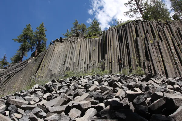
Established in 1911 by presidential proclamation, Devils Postpile National Monument protects and preserves the Devils Postpile formation, the 101-foot high Rainbow Falls, and pristine mountain scenery...
11 mi from route
~28 min detour
Free
near mile 127.8
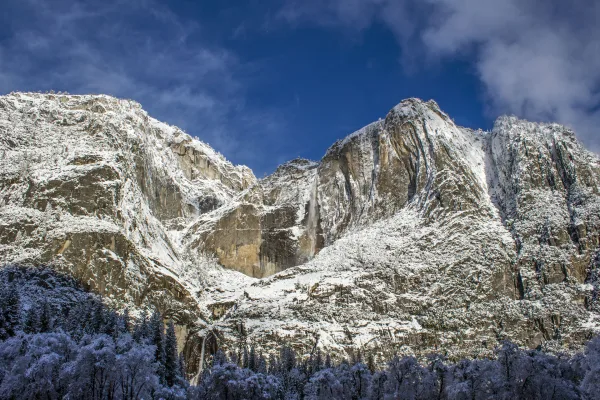
Not just a great valley, but a shrine to human foresight, the strength of granite, the power of glaciers, the persistence of life, and the tranquility of the High Sierra. First protected in 1864, Yose...
25 mi from route
~62 min detour
$35
near mile 109.5
Park data from the National Park Service API. Alerts update every 2 hours.
More Details
What kind of drive is this?
This journey presents a distinct mix of local roads, as the route maintains a 0% highway share throughout the entire 530.2-mile distance. You will experience a varied driving environment rather than a monotonous interstate grind, requiring your full attention as you transition between urban and local corridors. Because the longest stretch on any single road—such as Oakland Avenue—is 0 miles, you should be prepared for frequent transitions and navigation adjustments. The drive demands a steady, patient approach given the lack of high-speed highway connectivity. It is a practical, long-distance haul that favors consistent driving over rapid transit.
36% highway, the rest on surface roads — varied driving throughout.
59 navigation steps total — most of the decisions cluster near the start and finish.
Longest single stretch: 104.6 mi on Grand Army of the Republic Highway.
How Hard Is This Drive?
8/10
At 10h 52m, this is a long-haul route where pacing matters more than any single turn. This route has several spots where lane changes, forks, or exits need your full attention. The trickiest moment comes around 297.9 miles in near US 395 / Blue Star Memorial Highway.
Driving Effort8/10
Demanding - plan breaks and stay ahead of the key maneuvers
Balances navigation complexity with total wheel time.
This is a demanding drive. With 25 significant decision points across 529.4 miles, you will need to stay alert - especially through interchange areas and urban stretches. Consider splitting it into segments if you are not comfortable with fast highway navigation.
Where does it get tricky?
The main spots that need attention: at 297.9 miles (US 395 / Blue Star Memorial Highway): Highway fork - watch signs carefully. Lane positioning matters here; at 395.2 miles: Exit ramp - move to the correct lane early. Lane positioning matters here. Multiple destination signs - pick the right one; at 431.5 miles (I 215): Exit ramp - move to the correct lane early. Lane positioning matters here. Multiple destination signs - pick the right one.
Elevation Profile
High-altitude sections with notable climbs
7,608 ft39 ft
Total Climb
4,648 ft
Total Descent
10,851 ft
Highest Point
7,608 ft
~132.3 mi in
Elevation Range
7,568 ft
Notable High Points
6,608 ft at ~66.2 miles+87 ft prominence
7,608 ft at ~132.3 miles+653 ft prominence
3,879 ft at ~397 miles+584 ft prominence
Towns Mentioned on Route Signs
Based on OSRM destination-sign hints, not a full list of every settlement the road passes.
Between South Lake Tahoe, CA and San Diego, CA, road signs point toward Los Angeles and Indio.
South Lake Tahoe is a city in the Lake Tahoe region of California in El Dorado County. South Lake Tahoe, the largest town around the lake, sits on the south shore, and offers beautiful views of mountains covered with fir and pine trees, deep blue water year-round, and a wealth of outdoor activities. A popular location for skiers and snowboarders during the snowy winter season, Lake Tahoe is also home to miles of beaches for sun-tanning, boating, water skiing, and swimming in the summer.
From balmy beaches with a laid-back attitude to a gleaming modern image, San Diego offers much for the tourist to enjoy. Situated on the Southern California seacoast, San Diego is the second largest city in the state, with 1.4 million residents (2020), and has long attracted travelers for its ideal climate, miles of beaches, and location on the Mexican border right across from Tijuana.
But there's much more here than surfer culture and a quick hop across the border. A rich maritime and military heritage lives on in San Diego, which is home to the Pacific Fleet of the United States Navy. The city has also become known for its part in the wildlife conservation movement, owing to the presence of the world-renowned San Diego Zoo and Safari Park and the Scripps Institution of Oceanography. Natural scenery abounds from rocky tidepools and seaside cliffs to desert hills and canyons inland.
Top landmarks
•Balboa Park — historic park in San Diego, California
•Cabrillo National Monument — National Monument of the United States and historic district
Long-haul drive route profile with national parks nearby.
Frequently Asked Questions
The longest stretch is about 104.6 miles on Grand Army of the Republic Highway. The full list of main roads is in the Roads section above.
Yes — a 2-day pace is more comfortable than one long haul. A sensible stopping point is after roughly 265 miles on day one.
We did not find dedicated rest areas on this route. For a drive this long, plan bathroom and stretch breaks around gas stations, fast-food stops, or small-town downtowns — check the Nearby Places section for options.
It helps. This route has a higher-than-average number of complex decision points, which get harder in the dark. If the last hour of the trip is on surface roads or mountain grades, aim to arrive at San Diego, CA before sunset when you can. Check the Trip Plan for departure windows that land you in daylight.
Only with planning. This is a long drive for kids — consider splitting it into two days rather than pushing through. Plan at least 3 meaningful breaks. Dedicated rest areas are limited, so plan gas or food stops as your bathroom breaks.
The main spots that need attention: at 297.9 miles (US 395 / Blue Star Memorial Highway): Highway fork - watch signs carefully. Lane positioning matters here; at 395.2 miles: Exit ramp - move to the correct lane early. Lane positioning matters here. Multiple destination signs - pick the right one; at 431.5 miles (I 215): Exit ramp - move to the correct lane early. Lane positioning matters here. Multiple destination signs - pick the right one.
Yes — Cabrillo National Monument, Devils Postpile National Monument and Yosemite National Park. See the National Parks section for detour distances and tips on detours.
Not recommended in a single day. At 10.9 hours each way, a round trip means 21.8 hours of driving — that is an unsafe level of fatigue for most drivers. Plan at least one night at San Diego, CA before the return drive.