This extensive 1,674.8-mile journey from Sitka to Prudhoe Bay, Alaska, is a serious undertaking, estimated to take around 73 hours and 44 minutes of driving time. It's not a trip for a single day; with a recommended duration of 4 days, you'll need to plan for multiple overnight stops. The route primarily utilizes the Alaska Marine Highway between Whittier and Yakutat, transitioning to the George Parks Highway and finally the Dalton Highway. Expect a fuel cost of approximately $363 for this adventure. This drive offers a deep dive into Alaska's vast and varied landscapes, connecting two distinct regions within the state.
Trip Pace
Best split across 4 days
Treat the return leg as its own travel day rather than an afterthought.
Break Rhythm
21 planned breaks
Plan on a short reset every 3 to 4 hours to stay fresh behind the wheel.
Midpoint
837.4 miles from Sitka, AK
A natural place for your longest stop of the day
, about 50h 29m into the drive
.
Main Roads
Road
Distance
Duration
Dalton Highway
415.8 mi
14h 20m
Alaska Marine Highway - Whittier-Yakutat
334.5 mi
22h
George Parks Highway
299.8 mi
5h 58m
Alaska Marine Highway - Juneau-Yakutat
262.6 mi
17h
Alaska Marine Highway - Sitka-Juneau
153.9 mi
9h 30m
Elliott Highway
68.1 mi
1h 38m
Seward Highway
47.2 mi
58m
Glenn Highway
33 mi
38m
Longest stretch:
Dalton Highway
— 415.8 mi, about 14h 20m
Turn-by-Turn Driving Directions
Step-by-step road directions between Sitka, AK and Prudhoe Bay, AK.
Toward Wasilla, FairbanksUse the slight left / slight right lanes.
20
Continue on AK 3
4.2 mi·5 min·West Parks Highway
Use the left / straight lanes.
21
Continue on AK 3
300 mi·5 hr 58 min·George Parks Highway
Use the straight lane.
22
Take the exit
0.2 mi·24 sec
23
Keep slight left at fork
0.2 mi·28 sec
24
Turn left onto Geist Road
1.6 mi·2 min·Geist Road
25
Continue on Johansen Expressway
4.2 mi·5 min·Johansen Expressway
Use the left lane.
26
Turn left onto AK 2
9.1 mi·12 min·Steese Highway
Use the left / straight / right lanes.
27
Continue on AK 2
68 mi·1 hr 38 min·Elliott Highway
28
Continue on AK 11
416 mi·14 hr 20 min·Dalton Highway
29
At end of road, turn right onto Colleen Lake Road
0.9 mi·2 min·Colleen Lake Road
30
At end of road, turn right onto Spine Road
3.0 mi·7 min·Spine Road
31
Keep slight right at fork
1.4 mi·3 min
32
Continue on this road
0.2 mi·25 sec·this road
33
Arrive at destination
Trip Plan
Given the 73-hour, 44-minute duration and 1,674.8-mile length, splitting this trip over the recommended 4 days is essential for safety and enjoyment. Plan your fuel stops carefully, especially on the Dalton Highway, as services can be sparse; the estimated fuel cost is $363. With 21 stops planned, you have opportunities to rest and resupply, but be mindful of the longest stretch of 415.8 miles on the Dalton Highway, which requires ample preparation. Departing in the early morning during the summer months will maximize daylight hours for driving and allow you to experience the unique Alaskan summer conditions.
Morning Departure
Start early — leave by 6-7 AM to arrive at a reasonable hour.
Evening Departure
This is a long drive — plan for a morning departure or consider splitting it into two days.
This drive is better paced as a 4-day trip.
Plan roughly 21 meaningful breaks for fuel, food, and rest.
The halfway point lands around 837.4 miles from Sitka, AK, or about 50h 29m into the drive.
The longest continuous stretch on this route runs about 415.8 miles.
Consider an overnight stop or starting very early.
Departure
Before you leave
Start with fuel, water, and navigation already sorted so the first hour feels easy.
First stop
Around 220 miles or 13h 33m in
Use this first pause for coffee, a restroom break, and a quick traffic check ahead.
Halfway reset
Around 837.4 miles or 50h 29m in
This is the best place for your longest stop, a real meal, and a full fuel check.
Overnight split
Day 1 wrap after about 418.7 miles or 26h 25m
Stop before fatigue turns the last few hours into a grind. You want day two to start fresh, not just resumed.
Final approach
Final hour starts around 71h 37m
Traffic, exits, and arrival timing usually matter more near Prudhoe Bay, AK than in the middle of the route.
Before You Leave
+
Open the route before leaving Sitka, AK so your first major turns are already loaded.
+
Leave with enough water and a charging cable within reach, not packed away.
+
Check your fuel range against the first long segment, especially if you are starting outside city service areas.
+
Pick one backup stop option before the midpoint in case traffic changes your pacing.
+
Treat this as a 4-day road trip and book the overnight stop before the busiest arrival window.
Day 1
Settle into the route from Sitka, AK
Aim for roughly 419 miles and 18.4 hours of wheel time on this day.
Day 2
Keep the middle miles efficient
Aim for roughly 419 miles and 18.4 hours of wheel time on this day.
Day 3
Keep the middle miles efficient
Aim for roughly 419 miles and 18.4 hours of wheel time on this day.
Day 4
Finish the approach into Prudhoe Bay, AK
Aim for roughly 419 miles and 18.4 hours of wheel time on this day.
Your first comfortable stop window is around 220 miles from Sitka, AK.
This route usually feels better as a 4-day drive than as one long push.
Plan about 21 real breaks rather than only quick fuel stops.
The longest stretch is on Dalton Highway for about 415.8 miles.
Where to Stop
Rest stops, refuel points, and overnight suggestions along this route.
Place data sourced from public business listings. Hours and availability may vary.
Heads-up: tricky spots
5 of 15
5 decision points cluster between mile 0 and 851.6 — GPS handles the exact turns, but know they're coming. Your lane choice matters more than the turn itself.
5
0 mi into trip|~0m in|S-933 / Sawmill Creek Road
Turn left onto S-933 / Sawmill Creek Road
Navigation decision point
6
0.2 mi into trip|~0m in|F-99 / Halibut Point Road
Enter roundabout onto F-99 / Halibut Point Road
Roundabout - know your exit number before entering
5
160.8 mi into trip|~9h 43m in|Alaska Marine Highway - Juneau-Yakutat
Turn sharp left onto Alaska Marine Highway - Juneau-Yakutat
Sharp turn - reduce speed on approach
5
423.4 mi into trip|~26h 43m in|Alaska Marine Highway - Whittier-Yakutat
Turn sharp left onto Alaska Marine Highway - Whittier-Yakutat
Sharp turn - reduce speed on approach
8
851.6 mi into trip|~50h 45m in|AK 3 / East Parks Highway
Keep slight left at fork onto AK 3 / East Parks Highway toward Wasilla, Fairbanks
Highway fork - watch signs carefully. Lane positioning matters here. Multiple destination signs - pick the right one
Use the slight left / slight right lanes.
Toward Wasilla, Fairbanks
Fuel & Cost
Regular Gas
$327.44 one way
$654.89 round trip
$4.97/gal25.4 MPG avg586 kg CO2
Fuel Type
$/gal
One Way
Round Trip
midgrade
$5.28
$348.02
$696.03
premium
$5.46
$359.69
$719.37
diesel
$4.80
$316.23
$632.47
No toll roads detected on this route.
Estimated Trip Cost (one way, 1 person)
Fuel
$327
Hotel (3n)
$240–$420
Meals
$100–$200
Total
$667–$947
Rough estimate based on US averages. Hotel $80–$140/night, meals $25–$50/day.
Estimated CO2 emission: 586 kg one way.
Prices: EIA weekly data, 2026-07-13.
Driving Electric?
About $176 in charging
· 6 stops
· 67% less CO2
Vehicle Type
kWh
Stops
DC Fast
Home Charge
Average EV
502.4
6
$175.85
$80.39
Efficient EV
418.7
4
$146.55
$66.99
EV Truck/SUV
669.9
8
$234.47
$107.19
Gas CO2
586 kg
EV CO2
196 kg (67% less)
This is a long EV road trip requiring 6 charging stops. Plan your route around charger locations and allow extra time for charging.
DC fast charging avg $0.35/kWh. Home charging avg $0.16/kWh. US grid CO2: 0.39 kg/kWh.
Travel Intel
Current conditions at both ends of the drive.
Forecast as of Jul 16, 2026
Origin
Sitka, AK
Evening
in Sitka on Saturday
Local time
5:32 PM
AKDT
Current temp
64°F
Partly Sunny
NW 5 to 10 mph2% chanceLive forecast
Special Weather Statement
Special Weather Statement issued July 16 at 10:56AM AKDT by NWS Juneau AK
Special Weather Statement
Special Weather Statement issued July 16 at 10:42AM AKDT by NWS Juneau AK
Destination
Prudhoe Bay, AK
Evening
in Prudhoe Bay on Saturday
Local time
5:32 PM
AKDT
Current temp
40°F
Mostly Cloudy
N 10 mph13% chanceLive forecast
Special Weather Statement
Special Weather Statement issued July 16 at 10:56AM AKDT by NWS Juneau AK
Special Weather Statement
Special Weather Statement issued July 16 at 10:42AM AKDT by NWS Juneau AK
62°F
Houston, AK
419 mi in
66°F
Chickaloon, AK
1256 mi in
Seasonal Notes
Summer travel usually means heavier construction, hotter rest stops, and busier weekend traffic around major cities.
Winter travel shortens daylight, so a route that looks manageable on paper can feel much longer after dark.
Holiday weekends tend to make both departure and arrival windows slower than the raw route time suggests.
For long drives, weather on day two can matter just as much as conditions at departure, so check the whole travel window rather than only the first day.
Time zone
Same local time
Origin and destination are on the same clock, so arrival timing is easier to judge at a glance.
Temperature spread
24 degrees cooler at arrival
A meaningful temperature swing is a good cue to rethink layers, water, and how soon you want to arrive.
Road read
73h 44m on the road
This is long enough that the arrival forecast matters almost as much as departure conditions. Recheck both ends before you roll.
Weather data from the National Weather Service. Conditions may change; check closer to your travel date.
National Parks Near This Route
Worth a detour if your schedule allows.
Sitka National Historical Park
National Historical Park
On an island amid towering spruce and hemlock, Sitka National Historical Park preserves the site of a battle between invading Russian traders and Indigenous Kiks.ádi Tlingit. Totem poles from Tlingit...
Park data from the National Park Service API. Alerts update every 2 hours.
More Details
What kind of drive is this?
This route offers a unique mix of experiences, beginning with a significant portion on the Alaska Marine Highway, which is more about ferry travel than traditional driving. Once on land, you'll primarily navigate the George Parks Highway and the challenging Dalton Highway. With 0% highway share, you're looking at a consistent experience of non-interstate roads. The longest uninterrupted stretch you'll encounter is 415.8 miles on the Dalton Highway, a significant segment that demands focus and preparation. The character of the drive shifts from coastal marine transit to vast interior highways, with the Dalton Highway being a defining, rugged element.
0% highway, the rest on surface roads — varied driving throughout.
33 navigation steps total — most of the decisions cluster near the start and finish.
Longest single stretch: 415.8 mi on Dalton Highway.
How Hard Is This Drive?
7/10
At 73h 44m, this is a long-haul route where pacing matters more than any single turn. This route has several spots where lane changes, forks, or exits need your full attention. The trickiest moment comes early in the drive near S-933 / Sawmill Creek Road.
Driving Effort7/10
Demanding - plan breaks and stay ahead of the key maneuvers
Balances navigation complexity with total wheel time.
This is a demanding drive. With 15 significant decision points across 1674.8 miles, you will need to stay alert - especially through interchange areas and urban stretches. Consider splitting it into segments if you are not comfortable with fast highway navigation.
Where does it get tricky?
The main spots that need attention: near the start (S-933 / Sawmill Creek Road): Navigation decision point; at 0.2 miles (F-99 / Halibut Point Road): Roundabout - know your exit number before entering; at 160.8 miles (Alaska Marine Highway - Juneau-Yakutat): Sharp turn - reduce speed on approach.
Elevation Profile
Gently rolling terrain
2,133 ft0 ft
Total Climb
2,609 ft
Total Descent
2,603 ft
Highest Point
2,133 ft
~1555.2 mi in
Elevation Range
2,133 ft
Notable High Points
2,133 ft at ~1555.2 miles+945 ft prominence
Towns Mentioned on Route Signs
Based on OSRM destination-sign hints, not a full list of every settlement the road passes.
Between Sitka, AK and Prudhoe Bay, AK, road signs point toward Wasilla and Fairbanks.
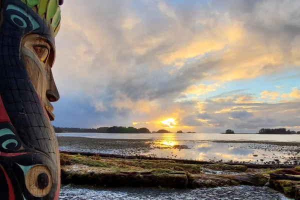
Sitka is a city of about 9,000 on the Pacific Ocean coast of Baranof Island in Alaska. First settled by Tlingit Aboriginal people, Sitka also has history as a Russian settlement, established in 1799 by Alexander Baranoff of the Russian American Company, which became the Russian capital of Alaska. In 1867, when Russia sold Alaska to the US, the transfer ceremony took place on Castle Hill at Sitka on October 18, a day celebrated as Alaska Day. Sitka now attracts about a quarter million visitors a year.
Top landmarks
•St. Michael's Cathedral — historic church in Alaska, United States
•Sitka National Historical Park — United States national park in Alaska
•Castle Hill — National Historic Landmark and state park in Sitka, Alaska, USA
Long-haul drive route profile with national parks nearby.
Frequently Asked Questions
The longest stretch is about 415.8 miles on Dalton Highway. The full list of main roads is in the Roads section above.
Yes — a 4-day pace is more comfortable than one long haul. A sensible stopping point is after roughly 419 miles on day one.
Yes — we found about 6 rest areas or service plazas within a short detour of the route (from OpenStreetMap). See the Rest Stops tab under Nearby Places for locations and mile markers. Plan to stretch, use the bathroom, and top off fluids every 2–3 hours on longer drives.
It helps. This route has a higher-than-average number of complex decision points, which get harder in the dark. If the last hour of the trip is on surface roads or mountain grades, aim to arrive at Prudhoe Bay, AK before sunset when you can. Check the Trip Plan for departure windows that land you in daylight.
Only with planning. This is a long drive for kids — consider splitting it into two days rather than pushing through. Plan at least 21 meaningful breaks. There are 6 rest areas along the route for bathroom stops.
Mostly yes along the main roads, but rural stretches through AK can have sparse or no coverage. Before you leave, download offline Google Maps or Apple Maps for the route, and consider downloading music or podcasts instead of streaming. If you depend on data for navigation, keep a paper backup of the turn-by-turn directions.
The main spots that need attention: near the start (S-933 / Sawmill Creek Road): Navigation decision point; at 0.2 miles (F-99 / Halibut Point Road): Roundabout - know your exit number before entering; at 160.8 miles (Alaska Marine Highway - Juneau-Yakutat): Sharp turn - reduce speed on approach.
Yes — Sitka National Historical Park. See the National Parks section for detour distances and tips on detours.
Not recommended in a single day. At 73.7 hours each way, a round trip means 147.5 hours of driving — that is an unsafe level of fatigue for most drivers. Plan at least one night at Prudhoe Bay, AK before the return drive.