Origin
Shandon, CA
Morning in Shandon on Sunday
Local time
8:49 AM
PDT
Current temp
44°F
Unavailable
Live forecast
Compiled and reviewed by the US Trip Planner planning team at COD Solutions Oy · Last reviewed Apr 19, 2026 · Editorial standards
Drive Time
3h 23m
Distance
174.1 mi
280 km
Drive Score
10/10
Great drive
Same Day?
Yes, doable
Fuel Cost
$40
one way
EV Charging
Unknown
Estimated drive times based on typical traffic patterns. Actual times may vary with weather, construction, and real-time conditions.

Shandon, CA
Wikimedia Commons

San Jose, CA
Wikimedia Commons
This 174.1-mile drive from Shandon, CA to San Jose, CA is easily manageable as a single-day trip, taking approximately 3 hours and 23 minutes. You'll navigate a mix of roads, including El Camino Real, South Valley Freeway, and CA 46, with about 30% of the journey on highways. Expect a fuel cost of around $40 for this journey. Given the relatively short duration and moderate distance, this route is ideal for a day trip, allowing for flexibility in your departure and arrival times. Both your origin and destination are within the Pacific Coast region, offering a consistent regional experience.
Trip Pace
Same-day drive is realistic
A same-day return is realistic if you keep stops short.
Break Rhythm
1 planned break
A short stop every 2 to 3 hours is enough for this drive.
Midpoint
87.1 miles from Shandon, CA
A natural place for your longest stop of the day , about 1h 42m into the drive .
| Road | Distance | Duration |
|---|---|---|
| El Camino Real | 117.7 mi | 2h 15m |
| South Valley Freeway | 26.3 mi | 30m |
| CA 46 | 15.6 mi | 18m |
| CA 85 | 5.2 mi | 6m |
| Guadalupe Parkway | 4.3 mi | 5m |
| Centre Street | 2.4 mi | 3m |
| Guadalupe Freeway | 0.4 mi | <1m |
| West Saint James Street | 0.2 mi | <1m |
Step-by-step road directions between Shandon, CA and San Jose, CA.
Start on Shandon Alley
Turn left onto Centre Street
Turn left onto CA 46
Take the exit
Merge onto US 101
Continue on US 101
Keep slight right at fork onto CA 85
Take the exit
Continue on CA 87
Continue on CA 87
Take the exit
Keep slight left at fork
Keep slight left at fork
Keep slight right at fork
Turn right onto West Saint James Street
Turn left onto North Market Street
Arrive at destination
For this 3-hour-plus drive, consider an early morning departure to maximize your day and potentially avoid some traffic as you approach San Jose. With only one recommended stop, you have plenty of flexibility to decide when and where to take a break. The estimated fuel cost of $40 should be factored into your budget. A specific tip for this route: pay attention to signage as you transition between CA 46, El Camino Real, and the South Valley Freeway, as these changes can happen quickly. This is a straightforward drive, but being aware of the road changes will make it smoother.
Morning Departure
An early start around 7-8 AM gets you there with plenty of daylight left.
Evening Departure
A late afternoon start means arriving after dark. Morning is better.
This is a comfortable same-day trip.
Departure
Before you leave
Start with fuel, water, and navigation already sorted so the first hour feels easy.
First stop
Around 38 miles or 45m in
Use this first pause for coffee, a restroom break, and a quick traffic check ahead.
Halfway reset
Around 87.1 miles or 1h 42m in
This is the best place for your longest stop, a real meal, and a full fuel check.
Final approach
Final hour starts around 2h 46m
Traffic, exits, and arrival timing usually matter more near San Jose, CA than in the middle of the route.
Open the route before leaving Shandon, CA so your first major turns are already loaded.
Leave with enough water and a charging cable within reach, not packed away.
Check your fuel range against the first long segment, especially if you are starting outside city service areas.
Day 1
Settle into the route from Shandon, CA
This is one driving day of about 174.1 miles and 3h 23m.
Rest stops, refuel points, and overnight suggestions along this route.

Mid-route town
Meal stop
87 mi into the route
Best for: Lunch, fuel, and a longer reset
This sits close to the middle of the route, so it works well for the longest stop of the day.
A short stop after about 38 miles helps settle the day before fatigue starts building.
The midpoint is around 87.1 miles from Shandon, CA, which is a good place for a longer meal and fuel stop.
Before the longest stretch
Fuel checkTop up before El Camino Real if your tank is already low. That segment runs about 117.7 miles.
These stop ideas are pacing suggestions — the exact town or exit can change with traffic, hotel plans, and fuel range.
5 decision points cluster between mile 162.2 and 173.7 — GPS handles the exact turns, but know they're coming. Your lane choice matters more than the turn itself.
Keep slight right at fork onto CA 85 toward CA 85 North: Cupertino, Mountain View
Highway fork - watch signs carefully. Lane positioning matters here. Multiple destination signs - pick the right one
Take the exit toward CA 87 North: Downtown San Jose
Exit ramp - move to the correct lane early. Lane positioning matters here
Take the exit toward CA 82
Exit ramp - move to the correct lane early. Lane positioning matters here
Keep slight left at fork toward CA 87 North: Santa Clara Street, Julian Street
Highway fork - watch signs carefully. Lane positioning matters here. Multiple destination signs - pick the right one
Keep slight right at fork toward Julian Street
Highway fork - watch signs carefully. Lane positioning matters here
Regular Gas
$40.02 one way
$80.03 round trip
| Fuel Type | $/gal | One Way | Round Trip |
|---|---|---|---|
| midgrade | $6.02 | $41.24 | $82.47 |
| premium | $6.18 | $42.34 | $84.68 |
| diesel | $5.61 | $38.44 | $76.88 |
No toll roads detected on this route.
Estimated Trip Cost (one way, 1 person)
Fuel
$40
Meals
$25–$50
Total
$65–$90
Rough estimate based on US averages. Hotel $80–$140/night, meals $25–$50/day.
Estimated CO2 emission: 60.9 kg one way. Prices: EIA weekly data, 2026-04-13.
Driving Electric?
About $18 in charging · 0 stops · 67% less CO2
| Vehicle Type | kWh | Stops | DC Fast | Home Charge |
|---|---|---|---|---|
| Average EV | 52.2 | 0 | $18.28 | $8.36 |
| Efficient EV | 43.5 | 0 | $15.23 | $6.96 |
| EV Truck/SUV | 69.6 | 0 | $24.37 | $11.14 |
Gas CO2
61 kg
EV CO2
20 kg (67% less)
This trip is well within single-charge range for most EVs. No charging stops needed if you start fully charged.
DC fast charging avg $0.35/kWh. Home charging avg $0.16/kWh. US grid CO2: 0.39 kg/kWh.
Current conditions at both ends of the drive.
Origin
Morning in Shandon on Sunday
Local time
8:49 AM
PDT
Current temp
44°F
Unavailable
Destination
Morning in San Jose on Sunday
Local time
8:49 AM
PDT
Current temp
44°F
Unavailable
Seasonal Notes
Summer travel usually means heavier construction, hotter rest stops, and busier weekend traffic around major cities.
Winter travel shortens daylight, so a route that looks manageable on paper can feel much longer after dark.
Holiday weekends tend to make both departure and arrival windows slower than the raw route time suggests.
Time zone
Origin and destination are on the same clock, so arrival timing is easier to judge at a glance.
Temperature spread
Both ends of the route are sitting at about the same temperature right now.
Road read
Use the two city cards together: check the sky where you start, then compare it with the local time and temperature at arrival.
Weather data from the National Weather Service. Conditions may change; check closer to your travel date.
Worth a detour if your schedule allows.
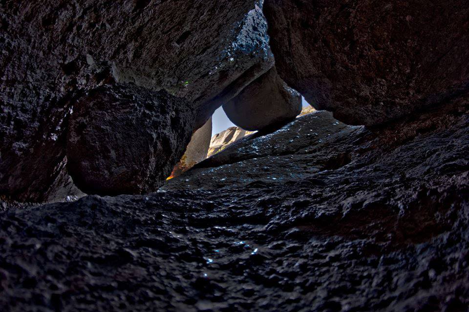
National Park
Around 23 million years ago, a series of volcanic eruptions shaped the landscape that is now Pinnacles National Park. The remnants of these ancient eruptions have formed a striking terrain of rocky sp...
Park data from the National Park Service API. Alerts update every 2 hours.
The drive presents a mixed profile, blending highway speeds with more local road conditions. While only 30% of the route is on highways, you'll encounter a substantial uninterrupted stretch of 117.7 miles on El Camino Real, offering a prolonged experience on this particular roadway. This means you’ll shift between faster travel on freeways like the South Valley Freeway and potentially slower, more varied conditions as you traverse El Camino Real. The road character will likely change as you progress, moving from more open stretches to areas with more local traffic and intersections.
This route mixes highway mileage with some local-road sections near the start or finish. This route has several spots where lane changes, forks, or exits need your full attention. The trickiest moment comes around 162.2 miles in near CA 85.
Demanding - plan breaks and stay ahead of the key maneuvers
Balances navigation complexity with total wheel time.
This is a demanding drive. With 11 significant decision points across 174.1 miles, you will need to stay alert - especially through interchange areas and urban stretches. Consider splitting it into segments if you are not comfortable with fast highway navigation.
Where does it get tricky?
The main spots that need attention: at 162.2 miles (CA 85): Highway fork - watch signs carefully. Lane positioning matters here. Multiple destination signs - pick the right one; at 167.4 miles: Exit ramp - move to the correct lane early. Lane positioning matters here; at 172.8 miles: Exit ramp - move to the correct lane early. Lane positioning matters here.
Based on OSRM destination-sign hints, not a full list of every settlement the road passes.
On the drive from Shandon, CA to San Jose, CA, road signs begin pointing toward Mountain View along the way.
Mountain View
Often called "the capital of Silicon Valley", San Jose is the largest city in the Bay Area, 3rd largest in California, and the 12th largest city in the United States, with a population of over 997,000 residents as of 2024. It was named the 6th safest big city in the U.S. in 2015. This clean, sprawling metropolis has sports, beautiful vistas, and ethnic enclaves and bleeds into the greater Bay Area for travelers who want to take their time in Northern California.
City content from Wikivoyage (CC BY-SA 4.0) and Wikidata (CC0).
Weekend Trip
Doable as a same-day drive at 3h 23m. Total distance: 174.1 miles.
Family Friendly
Moderate complexity with 1 natural rest stops along the way.
Solo Traveler
3h 23m drive, comfortable solo distance.
Scenic Drive
Mixed highway & surface route profile with national parks nearby.
Compiled by the US Trip Planner planning team at COD Solutions Oy from open government datasets — OSRM over OpenStreetMap for geometry, EIA for fuel prices, and NPS for national parks. See our methodology for refresh cadence and limitations.
Was this helpful?
Thanks for your feedback!
Your tip has been submitted. Thanks!
/500
Recent Tips
·
Explore more options from Shandon, CA or browse trips ending in San Jose, CA.
Looking for more statewide routes? Browse CA road trips.