This 66.1-mile journey from Santa Fe, NM to Ranchos de Taos, NM takes about 1 hour and 34 minutes and is best suited as a single-day adventure. With a modest fuel cost estimated at $10, this drive offers a straightforward connection within the Desert Southwest. It's a relatively short trip, making it an easy add-on or a dedicated excursion without the need for an overnight stay. You'll primarily navigate local roads, so expect a more intimate driving experience rather than a highway cruise. This route is perfect for those looking to explore more of the New Mexico landscape at a relaxed pace.
Trip Pace
Same-day drive is realistic
A same-day return is realistic if you keep stops short.
Midpoint
33.1 miles from Santa Fe, NM
A natural place for your longest stop of the day
, about 48m into the drive
.
Main Roads
Road
Distance
Duration
New Mexico State Highway 68
38.5 mi
53m
Taos Highway
12.2 mi
14m
Santa Fe Highway
8.7 mi
13m
South Riverside Drive
2.8 mi
5m
North Saint Francis Drive
1.5 mi
1m
Paseo de Peralta
0.6 mi
1m
Riverside Drive
0.5 mi
1m
North Guadalupe Street
0.4 mi
<1m
Longest stretch:
New Mexico State Highway 68
— 38.5 mi, about 53m
Turn-by-Turn Driving Directions
Step-by-step road directions between Santa Fe, NM and Ranchos de Taos, NM.
1
Start on East San Francisco Street
294 ft·15 sec·East San Francisco Street
2
Turn left onto Cathedral Place
238 ft·13 sec·Cathedral Place
3
Turn left onto East Palace Avenue
327 ft·13 sec·East Palace Avenue
4
Turn right onto Washington Avenue
0.3 mi·41 sec·Washington Avenue
5
Turn left onto NM 475
0.6 mi·1 min·Paseo de Peralta
6
Turn right onto North Guadalupe Street
0.4 mi·49 sec·North Guadalupe Street
Use the slight right lane.
7
Take the ramp
0.3 mi·34 sec
8
Merge onto US 84; US 285
1.5 mi·1 min·North Saint Francis Drive
9
Continue on US 84; US 285
12 mi·14 min·Taos Highway
10
Continue on US 84; US 285
8.7 mi·13 min·Santa Fe Highway
Use the left / straight / right lanes.
11
Continue on US 84; US 285
0.5 mi·1 min·Riverside Drive
12
Continue on NM 68
0.2 mi·19 sec·Riverside Drive Southeast
13
Continue on NM 68
2.8 mi·5 min·South Riverside Drive
14
Continue on NM 68
39 mi·53 min·New Mexico State Highway 68
15
Turn right onto Valerio Road
11 ft·0 sec·Valerio Road
16
Arrive at destination
Valerio Road
Trip Plan
Given the short 1 hour and 34-minute duration, you have a lot of flexibility with this drive. Departing Santa Fe in the morning allows you to arrive in Ranchos de Taos with ample time for exploration. With only 66.1 miles and a fuel cost around $10, you won't need to worry much about refueling stops. The main roads include Cathedral Place, East Palace Avenue, and Washington Avenue, so keep an eye on local signage. Since this is a turn-heavy local drive, it's wise to have your navigation ready to ensure you don't miss any key turns.
Morning Departure
Leave by 9 AM and you'll arrive before lunch.
Evening Departure
Even a 4 PM departure gets you there before dark in summer.
You can normally do this drive in one day.
You may only need one short stretch break if traffic stays light.
The halfway point lands around 33.1 miles from Santa Fe, NM, or about 48m into the drive.
The longest continuous stretch on this route runs about 38.5 miles.
This is a comfortable same-day trip.
Departure
Before you leave
Start with fuel, water, and navigation already sorted so the first hour feels easy.
First stop
Around 15 miles or 19m in
Use this first pause for coffee, a restroom break, and a quick traffic check ahead.
Halfway reset
Around 33.1 miles or 48m in
This is the best place for your longest stop, a real meal, and a full fuel check.
Final approach
Final hour starts around 1h 20m
Traffic, exits, and arrival timing usually matter more near Ranchos de Taos, NM than in the middle of the route.
Before You Leave
+
Open the route before leaving Santa Fe, NM so your first major turns are already loaded.
Day 1
Settle into the route from Santa Fe, NM
This is one driving day of about 66.1 miles and 1h 34m.
Your first comfortable stop window is around 15 miles from Santa Fe, NM.
This route can stay practical as a one-day drive if traffic stays reasonable.
The longest stretch is on New Mexico State Highway 68 for about 38.5 miles.
Where to Stop
Rest stops, refuel points, and overnight suggestions along this route.
Place data sourced from public business listings. Hours and availability may vary.
Heads-up: tricky spots
5 of 7
5 decision points cluster between mile 0.1 and 66.1 — GPS handles the exact turns, but know they're coming. Your lane choice matters more than the turn itself.
5
0.1 mi into trip|~0m in|Cathedral Place
Turn left onto Cathedral Place
Navigation decision point
4
0.1 mi into trip|~0m in|East Palace Avenue
Turn left onto East Palace Avenue
Navigation decision point
5
0.2 mi into trip|~0m in|Washington Avenue
Turn right onto Washington Avenue
Navigation decision point
4
1 mi into trip|~2m in|North Guadalupe Street
Turn right onto North Guadalupe Street
Lane positioning matters here
Use the slight right lane.
4
66.1 mi into trip|~1h 34m in|Valerio Road
Turn right onto Valerio Road
Navigation decision point
Fuel & Cost
Regular Gas
$9.98 one way
$19.97 round trip
$3.84/gal25.4 MPG avg23 kg CO2
Fuel Type
$/gal
One Way
Round Trip
midgrade
$4.21
$10.96
$21.92
premium
$4.56
$11.86
$23.73
diesel
$5.61
$14.59
$29.19
No toll roads detected on this route.
Estimated Trip Cost (one way, 1 person)
Fuel
$10
Meals
$25–$50
Total
$35–$60
Rough estimate based on US averages. Hotel $80–$140/night, meals $25–$50/day.
Estimated CO2 emission: 23.1 kg one way.
Prices: EIA weekly data, 2026-04-13.
Driving Electric?
About $7 in charging
· 0 stops
· 65% less CO2
Vehicle Type
kWh
Stops
DC Fast
Home Charge
Average EV
19.8
0
$6.94
$3.17
Efficient EV
16.5
0
$5.78
$2.64
EV Truck/SUV
26.4
0
$9.25
$4.23
Gas CO2
23 kg
EV CO2
8 kg (65% less)
This trip is well within single-charge range for most EVs. No charging stops needed if you start fully charged.
DC fast charging avg $0.35/kWh. Home charging avg $0.16/kWh. US grid CO2: 0.39 kg/kWh.
Travel Intel
Current conditions at both ends of the drive.
Forecast as of Apr 15, 2026
Origin
Santa Fe, NM
Morning
in Santa Fe on Sunday
Local time
6:04 AM
MDT
Current temp
72°F
Unavailable
Live forecast
Destination
Ranchos de Taos, NM
Morning
in Ranchos de Taos on Sunday
Local time
6:04 AM
MDT
Current temp
59°F
Unavailable
Live forecast
Seasonal Notes
Summer travel usually means heavier construction, hotter rest stops, and busier weekend traffic around major cities.
Winter travel shortens daylight, so a route that looks manageable on paper can feel much longer after dark.
Holiday weekends tend to make both departure and arrival windows slower than the raw route time suggests.
Time zone
Same local time
Origin and destination are on the same clock, so arrival timing is easier to judge at a glance.
Temperature spread
13 degrees cooler at arrival
A meaningful temperature swing is a good cue to rethink layers, water, and how soon you want to arrive.
Road read
1h 34m on the road
Use the two city cards together: check the sky where you start, then compare it with the local time and temperature at arrival.
Weather data from the National Weather Service. Conditions may change; check closer to your travel date.
National Parks Near This Route
Worth a detour if your schedule allows.
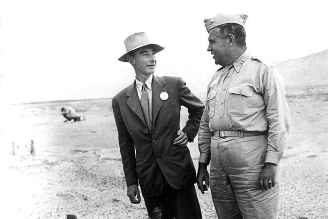
Manhattan Project National Historical Park
National Historical Park
The Manhattan Project is one of the most transformative events of the 20th century. It ushered in the nuclear age with the development of the world’s first atomic bombs. Most of this development took...
15 mi from route
~38 min detour
Free
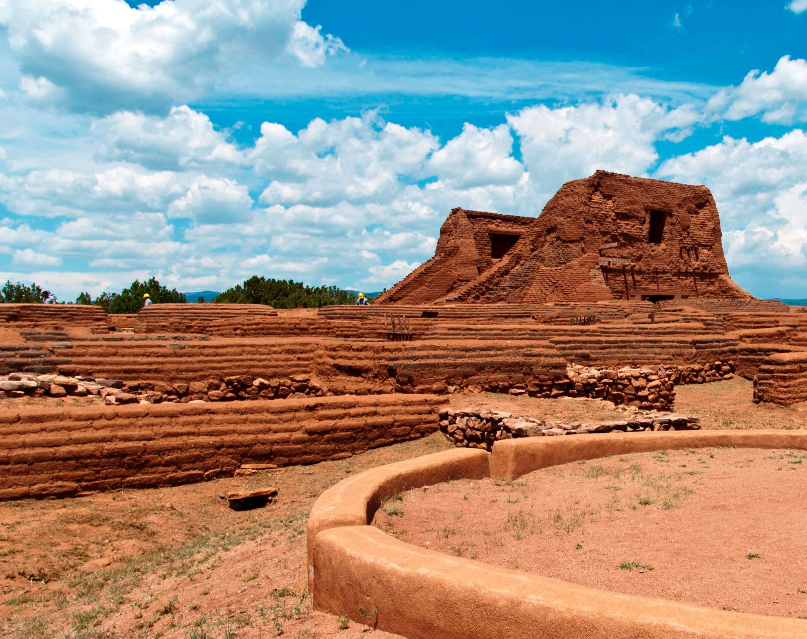
near mile 25.1
Pecos is a natural and cultural crossroads through which hunters, gatherers, traders, missionaries, immigrants, soldiers, ranchers, and other travelers passed and lived. Follow in their footsteps and...
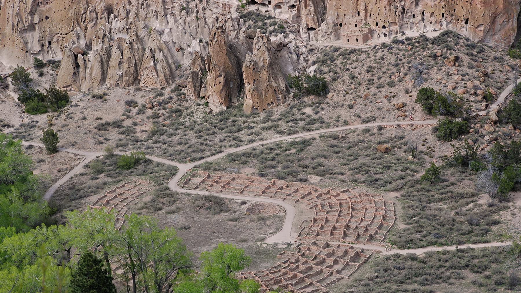
Bandelier National Monument protects over 33,000 acres of ruggedly beautiful canyon and mesa country. Petroglyphs, dwellings carved into the soft rock cliffs, and standing masonry walls pay tribute to...
Park data from the National Park Service API. Alerts update every 2 hours.
More Details
What kind of drive is this?
Expect a turn-heavy local drive for this entire 66.1-mile trip, with a 0% highway share. This means you'll be navigating through towns and on less direct routes, offering a more engaging driving experience. While there isn't a specific longest uninterrupted stretch noted, the nature of this route suggests frequent intersections and changes in speed limits. The drive will likely feel more like exploring backroads than covering long distances quickly. Prepare for a more hands-on approach to navigation, typical of local transit rather than high-speed travel.
58% highway, the rest on surface roads — varied driving throughout.
16 navigation steps total — most of the decisions cluster near the start and finish.
Longest single stretch: 38.5 mi on New Mexico State Highway 68.
How Hard Is This Drive?
2/10
This route mixes highway mileage with some local-road sections near the start or finish. Navigation is very simple - set it and forget it for most of the drive. The trickiest moment comes around 0.1 miles in near Cathedral Place.
Driving Effort2/10
Very easy - short and simple to drive
Balances navigation complexity with total wheel time.
The drive from Santa Fe, NM to Ranchos de Taos, NM is easy. At 1h 34m with 58% highway, most drivers will find it relaxed and low-stress.
Where does it get tricky?
The main spots that need attention: at 0.1 miles (Cathedral Place): Navigation decision point; at 0.1 miles (East Palace Avenue): Navigation decision point; at 0.2 miles (Washington Avenue): Navigation decision point.
Who Is This Route For?
Weekend Trip
Doable as a same-day drive at 1h 34m. Total distance: 66.1 miles.
Family Friendly
Moderate complexity with 0 natural rest stops along the way.
Mixed highway & surface route profile with national parks nearby.
Frequently Asked Questions
The longest stretch is about 38.5 miles on New Mexico State Highway 68. The full list of main roads is in the Roads section above.
Yes. At under 2 hours behind the wheel, this works well for families — plan one quick stop if you have younger kids.
Mostly yes along the main roads, but rural stretches through NM can have sparse or no coverage. Before you leave, download offline Google Maps or Apple Maps for the route, and consider downloading music or podcasts instead of streaming. If you depend on data for navigation, keep a paper backup of the turn-by-turn directions.
The main spots that need attention: at 0.1 miles (Cathedral Place): Navigation decision point; at 0.1 miles (East Palace Avenue): Navigation decision point; at 0.2 miles (Washington Avenue): Navigation decision point.
Yes — Manhattan Project National Historical Park, Pecos National Historical Park and Bandelier National Monument. See the National Parks section for detour distances and tips on detours.
Yes. A round trip is manageable in a single day if you plan a break at Ranchos de Taos, NM before heading back.