Saint Paul, MN to Tyler, MN is 185 miles and takes about 4h via US 212, with a fuel budget near $27 and enough daylight to finish in a day. This drive stays within the Midwest region, specifically Minnesota, making it a straightforward trip. The profile is mixed highway and surface roads, offering a blend of faster travel and more local cruising. With a recommended one-day drive, you can expect a relatively quick transit between these two points. It's a practical option if you're looking to cover this distance without needing an overnight stay.
Trip Pace
Same-day drive is realistic
A same-day return is possible, but it will make for a full day on the road.
Break Rhythm
1 planned break
Plan on a short reset every 3 to 4 hours to stay fresh behind the wheel.
Midpoint
92.5 miles from Saint Paul, MN
A natural place for your longest stop of the day
, about 1h 58m into the drive
.
Main Roads
Road
Distance
Duration
US 212
36.4 mi
43m
West Bridge Street
35.1 mi
44m
280th Street
31.2 mi
42m
State Highway 23
22.3 mi
28m
MN 5
15.2 mi
19m
US Highway 212
12.8 mi
15m
State Highway 15
12.6 mi
15m
US 71
6.6 mi
9m
Longest stretch:
US 212
— 36.4 mi, about 43m
Traffic on I-494
Hour-of-day weekday pattern from 7 FHWA count stations on your route.
Peak
7 AM
~5,010 veh/hr typical
Quietest
2 AM
~339 veh/hr
Peak-to-quiet ratio
14.8×
busier at peak than in the quiet hours
12a6anoon6p11p
Averaged across 18 weeks of 2023 FHWA Travel Monitoring Analysis System data. Weekday hours only (Mon–Fri).
Turn-by-Turn Driving Directions
Step-by-step road directions between Saint Paul, MN and Tyler, MN.
1
Start on Wabasha Street North
198 ft·14 sec·Wabasha Street North
2
Turn left onto 4th Street West
0.1 mi·35 sec·4th Street West
3
Turn left onto Market Street
264 ft·12 sec·Market Street
4
Turn right onto Kellogg Boulevard West
261 ft·8 sec·Kellogg Boulevard West
5
Turn slight left onto Exchange Street South
0.2 mi·40 sec·Exchange Street South
6
Turn left onto Eagle Parkway
0.2 mi·43 sec·Eagle Parkway
7
Turn right onto CH 37
5.1 mi·8 min·Shepard Road
Use the right lane.
8
Continue on South Mississippi River Boulevard
266 ft·7 sec·South Mississippi River Boulevard
9
Take the exit
0.3 mi·33 sec
Toward MN 5 West
10
Merge onto MN 5
13 mi·16 min·MN 5
Use the straight / slight right lanes.
11
Keep slight left at fork onto I 494; MN 5
0.3 mi·25 sec·I 494; MN 5
12
Take the exit onto MN 5
1.8 mi·2 min·MN 5
Exit 11CToward MN 5 West, US 212 WestUse the straight / right lanes.
13
Keep slight left at fork onto US 212
36 mi·43 min·US 212
Use the slight left lane.
14
Enter roundabout onto US 212
145 ft·2 sec·US Highway 212
15
Continue on US 212
13 mi·15 min·US Highway 212
16
Turn left onto MN 15
13 mi·15 min·State Highway 15
17
Turn right onto MN 19
31 mi·42 min·280th Street
18
At end of road, turn left onto US 71
6.6 mi·9 min·US 71
Use the straight lane.
19
Continue on MN 19
35 mi·44 min·West Bridge Street
Use the straight lane.
20
Continue on MN 19; MN 68
0.5 mi·51 sec·East College Drive
21
Turn left onto MN 23
22 mi·28 min·State Highway 23
22
Take the exit onto US 14/MN 23
0.2 mi·27 sec·US 14/MN 23
23
Turn right onto US 14
0.2 mi·13 sec·US Highway 14
24
Continue on US 14
0.5 mi·40 sec·Garfield Street
25
Continue on US 14
4.4 mi·5 min·US Highway 14
26
Turn right onto CR 7
0.4 mi·1 min·South Tyler Street
27
Continue on CR 7
0.2 mi·24 sec·Strong Street
28
Arrive at destination
CR 7
Trip Plan
Since this is a 4-hour drive, leaving Saint Paul in the morning allows you to reach Tyler with plenty of daylight remaining. There's one recommended stop, which is ample for a trip of this length, so you can decide if you want to break it up or push through. Keep an eye on your fuel levels, especially as you transition from highway to surface roads; the estimated fuel cost of $27 suggests moderate consumption. Given the short duration, you have the flexibility to depart at your convenience, but plan for potential local traffic as you approach your destination.
Morning Departure
An early start around 7-8 AM gets you there with plenty of daylight left.
Evening Departure
A late afternoon start means arriving after dark. Morning is better.
You can normally do this drive in one day.
Plan roughly 1 meaningful break for fuel, food, and rest.
The halfway point lands around 92.5 miles from Saint Paul, MN, or about 1h 58m into the drive.
The longest continuous stretch on this route runs about 36.4 miles.
This is a comfortable same-day trip.
Departure
Before you leave
Start with fuel, water, and navigation already sorted so the first hour feels easy.
First stop
Around 41 miles or 54m in
Use this first pause for coffee, a restroom break, and a quick traffic check ahead.
Halfway reset
Around 92.5 miles or 1h 58m in
This is the best place for your longest stop, a real meal, and a full fuel check.
Final approach
Final hour starts around 3h 16m
Traffic, exits, and arrival timing usually matter more near Tyler, MN than in the middle of the route.
Before You Leave
+
Open the route before leaving Saint Paul, MN so your first major turns are already loaded.
+
Leave with enough water and a charging cable within reach, not packed away.
+
Check your fuel range against the first long segment, especially if you are starting outside city service areas.
Day 1
Settle into the route from Saint Paul, MN
This is one driving day of about 185 miles and 4h.
Your first comfortable stop window is around 41 miles from Saint Paul, MN.
This route can stay practical as a one-day drive if traffic stays reasonable.
Plan about 1 real break rather than only quick fuel stops.
The longest stretch is on US 212 for about 36.4 miles.
Where to Stop
Rest stops, refuel points, and overnight suggestions along this route.
Place data sourced from public business listings. Hours and availability may vary.
Heads-up: tricky spots
5 of 17
5 decision points cluster between mile 0 and 114.6 — GPS handles the exact turns, but know they're coming. Your lane choice matters more than the turn itself.
5
0 mi into trip|~0m in|4th Street West
Turn left onto 4th Street West
Navigation decision point
6
0.7 mi into trip|~2m in|CH 37 / Shepard Road
Turn right onto CH 37 / Shepard Road
Lane positioning matters here
Use the right lane.
8
19.9 mi into trip|~29m in|MN 5
Take the exit onto MN 5 toward MN 5 West, US 212 West
Exit ramp - move to the correct lane early. Lane positioning matters here. Multiple destination signs - pick the right one
Use the straight / right lanes.
Exit 11C
Toward MN 5 West, US 212 West
6
21.6 mi into trip|~31m in|US 212
Keep slight left at fork onto US 212
Highway fork - watch signs carefully. Lane positioning matters here
Use the slight left lane.
7
114.6 mi into trip|~2h 28m in|US 71
At end of road, turn left onto US 71
Lane positioning matters here
Use the straight lane.
Fuel & Cost
Regular Gas
$27.79 one way
$55.57 round trip
$3.82/gal25.4 MPG avg65 kg CO2
Fuel Type
$/gal
One Way
Round Trip
midgrade
$4.12
$30.00
$60.00
premium
$4.60
$33.51
$67.02
diesel
$4.80
$34.93
$69.86
No toll roads detected on this route.
Estimated Trip Cost (one way, 1 person)
Fuel
$28
Meals
$25–$50
Total
$53–$78
Rough estimate based on US averages. Hotel $80–$140/night, meals $25–$50/day.
Estimated CO2 emission: 64.7 kg one way.
Prices: EIA weekly data, 2026-07-13.
EV Charging Along Route
5 DC fast chargers
· Coverage: good
Cesar Chavez
Saint Paul, MN
ZEFNET
2 DCFC
Bates & 7th
Saint Paul, MN
ZEFNET
2 DCFC
Lot W Jackson & 14th
Saint Paul, MN
ZEFNET
2 DCFC
St Joseph's Lane & 7th St
Saint Paul, MN
ZEFNET
2 DCFC
Aurora & Rice
Saint Paul, MN
ZEFNET
2 DCFC
ZEFNET: 5
Station data from NREL Alternative Fuel Stations database.
Driving Electric?
About $19 in charging
· 0 stops
· 66% less CO2
Vehicle Type
kWh
Stops
DC Fast
Home Charge
Average EV
55.5
0
$19.43
$8.88
Efficient EV
46.3
0
$16.19
$7.40
EV Truck/SUV
74
0
$25.90
$11.84
Gas CO2
65 kg
EV CO2
22 kg (66% less)
This trip is well within single-charge range for most EVs. No charging stops needed if you start fully charged.
DC fast charging avg $0.35/kWh. Home charging avg $0.16/kWh. US grid CO2: 0.39 kg/kWh.
Travel Intel
Current conditions at both ends of the drive.
Forecast as of Jul 19, 2026
Origin
Saint Paul, MN
Late night
in Saint Paul on Sunday
Local time
4:07 AM
CDT
Current temp
69°F
Mostly Clear
ESE 0 to 5 mph0% chanceLive forecast
Destination
Tyler, MN
Late night
in Tyler on Sunday
Local time
4:07 AM
CDT
Current temp
63°F
Mostly Clear
SSE 5 mph0% chanceLive forecast
89°F
Gaylord, MN
93 mi in
Seasonal Notes
Summer travel usually means heavier construction, hotter rest stops, and busier weekend traffic around major cities.
Winter travel shortens daylight, so a route that looks manageable on paper can feel much longer after dark.
Holiday weekends tend to make both departure and arrival windows slower than the raw route time suggests.
Time zone
Same local time
Origin and destination are on the same clock, so arrival timing is easier to judge at a glance.
Temperature spread
6 degrees cooler at arrival
A meaningful temperature swing is a good cue to rethink layers, water, and how soon you want to arrive.
Road read
4h on the road
An early start around 7-8 AM gets you there with plenty of daylight left.
Weather data from the National Weather Service. Conditions may change; check closer to your travel date.
National Parks Near This Route
Worth a detour if your schedule allows.
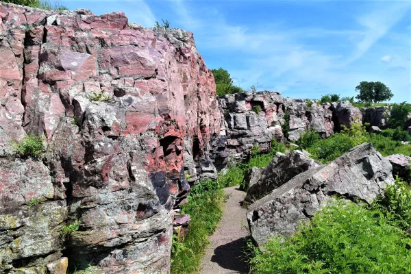
Pipestone National Monument
National Monument
For over 3,000 years, Indigenous people have quarried the red stone at this site to make pipes used in prayer and ceremony - a tradition that continues to this day and makes this site sacred to many p...
21 mi from route
~51 min detour
Free
near mile 185
Park data from the National Park Service API. Alerts update every 2 hours.
More Details
What kind of drive is this?
About 60% of this 185-mile route is on highways, meaning you'll experience some solid cruising before transitioning to surface roads. The longest continuous stretch on US 212 is 36.4 miles, offering a good period of uninterrupted driving. You'll eventually move onto West Bridge Street and 280th Street, which will feel more like local roads. Expect a shift from highway speeds to more typical surface road conditions as you get closer to Tyler.
60% highway — fuel and pacing are the main things to plan.
28 navigation steps total — most of the decisions cluster near the start and finish.
Longest single stretch: 36.4 mi on US 212.
How Hard Is This Drive?
7/10
This route mixes highway mileage with some local-road sections near the start or finish. This route has several spots where lane changes, forks, or exits need your full attention. The trickiest moment comes early in the drive near 4th Street West.
Driving Effort7/10
Demanding - plan breaks and stay ahead of the key maneuvers
Balances navigation complexity with total wheel time.
This is a demanding drive. With 17 significant decision points across 185 miles, you will need to stay alert - especially through interchange areas and urban stretches. Consider splitting it into segments if you are not comfortable with fast highway navigation.
Where does it get tricky?
The main spots that need attention: near the start (4th Street West): Navigation decision point; at 0.7 miles (CH 37 / Shepard Road): Lane positioning matters here; at 19.9 miles (MN 5): Exit ramp - move to the correct lane early. Lane positioning matters here. Multiple destination signs - pick the right one.
Saint Paul (or St. Paul) is the capital city and the second largest city of the US state of Minnesota. Along with the slightly larger Minneapolis it forms the urban core of the Twin Cities region, the third largest metropolis in the Midwest.
Top landmarks
•Minnesota State Capitol — state capitol building of the U.S. state of Minnesota
•Cathedral of Saint Paul, National Shrine of the Apostle Paul — cathedral in Saint Paul, Minnesota, USA
•Saint Paul Union Depot — train station in Saint Paul, Minnesota
Doable as a same-day drive at 4h. Total distance: 185 miles.
Family Friendly
Moderate complexity with 1 natural rest stops along the way.
Solo Traveler
4h drive, comfortable solo distance.
Frequently Asked Questions
The longest stretch is about 36.4 miles on US 212. The full list of main roads is in the Roads section above.
Yes — we found about 1 rest area or service plaza within a short detour of the route (from OpenStreetMap). See the Rest Stops tab under Nearby Places for locations and mile markers. Plan to stretch, use the bathroom, and top off fluids every 2–3 hours on longer drives.
It helps. This route has a higher-than-average number of complex decision points, which get harder in the dark. If the last hour of the trip is on surface roads or mountain grades, aim to arrive at Tyler, MN before sunset when you can. Check the Trip Plan for departure windows that land you in daylight.
Only with planning. This is a long drive for kids — consider splitting it into two days rather than pushing through. Plan at least 1 meaningful breaks. There are 1 rest area along the route for bathroom stops.
The main spots that need attention: near the start (4th Street West): Navigation decision point; at 0.7 miles (CH 37 / Shepard Road): Lane positioning matters here; at 19.9 miles (MN 5): Exit ramp - move to the correct lane early. Lane positioning matters here. Multiple destination signs - pick the right one.
Yes — Pipestone National Monument. See the National Parks section for detour distances and tips on detours.
Possible but tiring. At 4.0 hours each way, an in-and-out day trip would put you behind the wheel for 8.0 hours — manageable with a long break at Tyler, MN, but most travelers stay overnight.