Traveling from Pueblo to Columbine Valley covers 111.6 miles and takes approximately 2 hours and 5 minutes. Given the manageable duration, this trip is perfectly suited as a simple one-day excursion within the Mountain West region. You should budget about $17 for fuel to complete the journey. The route utilizes the Ronald Reagan Highway, the John F. Kennedy Memorial Highway, and the Monument Valley Freeway. Because there are no designated stops required, you can easily complete this drive in a single push without needing an overnight stay. It is an efficient way to transit between these two Colorado locations, offering a straightforward travel experience for those looking to reach their destination without unnecessary delays.
Trip Pace
Same-day drive is realistic
A same-day return is realistic if you keep stops short.
Midpoint
55.8 miles from Pueblo, CO
A natural place for your longest stop of the day
, about 1h 1m into the drive
.
Main Roads
Road
Distance
Duration
Ronald Reagan Highway
68.9 mi
1h 11m
John F. Kennedy Memorial Highway
12.9 mi
12m
Monument Valley Freeway
8.5 mi
9m
CO 470
7.1 mi
8m
South Freeway
6.1 mi
8m
Santa Fe Drive
3.5 mi
5m
CO 470 EXPR
1 mi
1m
West Bowles Avenue
0.8 mi
1m
Longest stretch:
Ronald Reagan Highway
— 68.9 mi, about 1h 11m
Traffic on I-25
Hour-of-day weekday pattern from 12 FHWA count stations on your route.
Peak
4 PM
~3,880 veh/hr typical
Quietest
2 AM
~190 veh/hr
Peak-to-quiet ratio
20.4×
busier at peak than in the quiet hours
12a6anoon6p11p
Averaged across 52 weeks of 2023 FHWA Travel Monitoring Analysis System data. Weekday hours only (Mon–Fri).
Turn-by-Turn Driving Directions
Step-by-step road directions between Pueblo, CO and Columbine Valley, CO.
1
Start on this road
0.2 mi·35 sec·this road
Toward Abriendo Avenue
2
Turn left onto Elm Street
29 ft·6 sec·Elm Street
3
Take the ramp
165 ft·4 sec
4
Keep slight left at fork
0.4 mi·57 sec
5
Merge onto I 25
6.1 mi·8 min·South Freeway
Use the straight lane.
6
Continue on I 25
13 mi·12 min·John F. Kennedy Memorial Highway
Use the straight / slight right lanes.
7
Continue on I 25
23 mi·23 min·Ronald Reagan Highway
Use the straight / slight right lanes.
8
Continue on I 25; US 24
8.5 mi·9 min·Monument Valley Freeway
Use the straight / slight right lanes.
9
Continue on I 25
46 mi·47 min·Ronald Reagan Highway
Use the straight / slight right lanes.
10
Take the exit
0.2 mi·21 sec
Exit 194Toward CO 470 West, E 470 North Toll: Grand Junction, LimonUse the straight / slight right lanes.
11
Keep slight left at fork
0.4 mi·50 sec
Exit 194Toward CO 470 West: Grand JunctionUse the slight left lane.
12
Keep slight right at fork
0.5 mi·50 sec
Exit 194Toward CO 470 West: Grand Junction, Quebec StreetUse the slight right lane.
13
Continue on CO 470
6.0 mi·6 min·CO 470
Use the straight / slight right lanes.
14
Take the exit
162 ft·2 sec
Toward CO 470 ExpressUse the slight left lane.
15
Merge onto CO 470 EXPR
1.0 mi·1 min·CO 470 EXPR
16
Take the exit
125 ft·1 sec
Toward CO 470 West
17
Merge onto CO 470
1.1 mi·1 min·CO 470
18
Take the exit
0.4 mi·51 sec
Exit 17Toward US 85: Santa Fe DriveUse the straight / slight right lanes.
19
Turn right onto US 85
3.5 mi·5 min·Santa Fe Drive
Use the left lane.
20
Turn left onto West Bowles Avenue
0.8 mi·1 min·West Bowles Avenue
Use the left lane.
21
Turn left onto South Middlefield Road
0.4 mi·1 min·South Middlefield Road
22
Turn left onto Niblick Lane
0.2 mi·53 sec·Niblick Lane
23
Arrive at destination
Niblick Lane
Trip Plan
Since this is a relatively short trip, you have plenty of flexibility regarding your departure time. Aim to hit the road when local traffic is lightest to ensure you maintain your estimated 2-hour and 5-minute travel time. Given that the route is a single, continuous stretch without planned stops, make sure your vehicle is fueled up before you leave to cover the $17 estimated cost. Pay close attention to the turn-heavy sections of the local roads, as they require more frequent adjustments than standard highway cruising. Use the simplicity of the 111.6-mile distance to your advantage by planning your arrival to coincide with your personal schedule rather than worrying about mid-trip rest points.
Morning Departure
Leave by 9 AM and you'll arrive before lunch.
Evening Departure
Even a 4 PM departure gets you there before dark in summer.
You can normally do this drive in one day.
You may only need one short stretch break if traffic stays light.
The halfway point lands around 55.8 miles from Pueblo, CO, or about 1h 1m into the drive.
The longest continuous stretch on this route runs about 68.9 miles.
This is a comfortable same-day trip.
Departure
Before you leave
Start with fuel, water, and navigation already sorted so the first hour feels easy.
First stop
Around 25 miles or 28m in
Use this first pause for coffee, a restroom break, and a quick traffic check ahead.
Halfway reset
Around 55.8 miles or 1h 1m in
This is the best place for your longest stop, a real meal, and a full fuel check.
Final approach
Final hour starts around 1h 38m
Traffic, exits, and arrival timing usually matter more near Columbine Valley, CO than in the middle of the route.
Before You Leave
+
Open the route before leaving Pueblo, CO so your first major turns are already loaded.
+
Leave with enough water and a charging cable within reach, not packed away.
+
Check your fuel range against the first long segment, especially if you are starting outside city service areas.
Day 1
Settle into the route from Pueblo, CO
This is one driving day of about 111.6 miles and 2h 5m.
Your first comfortable stop window is around 25 miles from Pueblo, CO.
This route can stay practical as a one-day drive if traffic stays reasonable.
The longest stretch is on Ronald Reagan Highway for about 68.9 miles.
Where to Stop
Rest stops, refuel points, and overnight suggestions along this route.
Place data sourced from public business listings. Hours and availability may vary.
Heads-up: tricky spots
5 of 17
5 decision points cluster between mile 97.1 and 106.3 — GPS handles the exact turns, but know they're coming. Your lane choice matters more than the turn itself.
8
97.1 mi into trip|~1h 43m in
Take the exit toward CO 470 West, E 470 North Toll: Grand Junction, Limon
Exit ramp - move to the correct lane early. Lane positioning matters here. Multiple destination signs - pick the right one
Use the straight / slight right lanes.
Exit 194
Toward CO 470 West, E 470 North Toll: Grand Jun...
8
97.3 mi into trip|~1h 44m in
Keep slight left at fork toward CO 470 West: Grand Junction
Highway fork - watch signs carefully. Lane positioning matters here
Use the slight left lane.
Exit 194
Toward CO 470 West: Grand Junction
9
97.7 mi into trip|~1h 45m in
Keep slight right at fork toward CO 470 West: Grand Junction, Quebec Street
Highway fork - watch signs carefully. Lane positioning matters here. Multiple destination signs - pick the right one
Use the slight right lane.
Exit 194
Toward CO 470 West: Grand Junction, Quebec Stre...
6
104.2 mi into trip|~1h 52m in
Take the exit toward CO 470 Express
Exit ramp - move to the correct lane early. Lane positioning matters here
Use the slight left lane.
Toward CO 470 Express
7
106.3 mi into trip|~1h 55m in
Take the exit toward US 85: Santa Fe Drive
Exit ramp - move to the correct lane early. Lane positioning matters here
Use the straight / slight right lanes.
Exit 17
Toward US 85: Santa Fe Drive
Fuel & Cost
Regular Gas
$17.02 one way
$34.03 round trip
$3.87/gal25.4 MPG avg39 kg CO2
Fuel Type
$/gal
One Way
Round Trip
midgrade
$4.12
$18.09
$36.18
premium
$4.45
$19.57
$39.13
diesel
$4.80
$21.07
$42.14
No toll roads detected on this route.
Estimated Trip Cost (one way, 1 person)
Fuel
$17
Meals
$25–$50
Total
$42–$67
Rough estimate based on US averages. Hotel $80–$140/night, meals $25–$50/day.
Estimated CO2 emission: 39 kg one way.
Prices: EIA weekly data, 2026-07-13.
Driving Electric?
About $12 in charging
· 0 stops
· 67% less CO2
Vehicle Type
kWh
Stops
DC Fast
Home Charge
Average EV
33.5
0
$11.72
$5.36
Efficient EV
27.9
0
$9.77
$4.46
EV Truck/SUV
44.6
0
$15.62
$7.14
Gas CO2
39 kg
EV CO2
13 kg (67% less)
This trip is well within single-charge range for most EVs. No charging stops needed if you start fully charged.
DC fast charging avg $0.35/kWh. Home charging avg $0.16/kWh. US grid CO2: 0.39 kg/kWh.
Travel Intel
Current conditions at both ends of the drive.
Forecast as of Jul 19, 2026
Origin
Pueblo, CO
Morning
in Pueblo on Sunday
Local time
11:43 AM
MDT
Current temp
65°F
Mostly Clear
NNE 0 to 10 mph3% chanceLive forecast
Heat Advisory
Heat Advisory issued July 18 at 4:46AM MDT until July 20 at 9:00PM MDT by NWS Denver CO
Destination
Columbine Valley, CO
Morning
in Columbine Valley on Sunday
Local time
11:43 AM
MDT
Current temp
65°F
Mostly Clear
S 7 mph0% chanceLive forecast
Heat Advisory
Heat Advisory issued July 18 at 4:46AM MDT until July 20 at 9:00PM MDT by NWS Denver CO
Seasonal Notes
Summer travel usually means heavier construction, hotter rest stops, and busier weekend traffic around major cities.
Winter travel shortens daylight, so a route that looks manageable on paper can feel much longer after dark.
Holiday weekends tend to make both departure and arrival windows slower than the raw route time suggests.
Time zone
Same local time
Origin and destination are on the same clock, so arrival timing is easier to judge at a glance.
Temperature spread
Very similar conditions
Both ends of the route are sitting at about the same temperature right now.
Road read
2h 5m on the road
The weather snapshot is not static. If you are leaving later, give both cities one more quick forecast check before departure.
Weather data from the National Weather Service. Conditions may change; check closer to your travel date.
National Parks Near This Route
Worth a detour if your schedule allows.
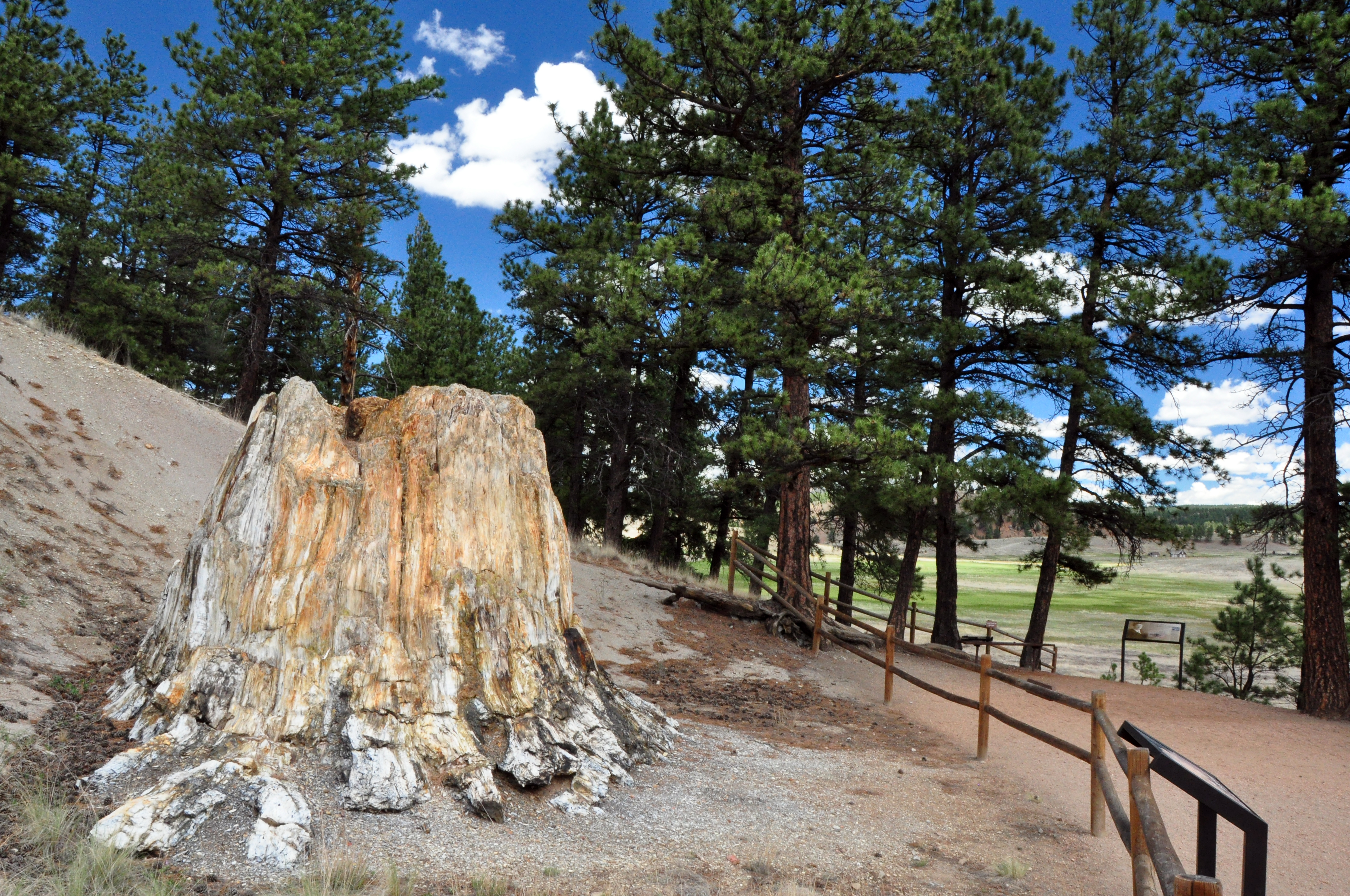
Florissant Fossil Beds National Monument
National Monument
Beneath a grassy mountain valley in central Colorado lies one of the richest and most diverse fossil deposits in the world. Petrified redwood stumps up to 14 feet wide and thousands of detailed fossil...
Park data from the National Park Service API. Alerts update every 2 hours.
More Details
What kind of drive is this?
Expect a turn-heavy local drive that demands your full attention behind the wheel. While about 20% of the route consists of highway travel, the remainder of the journey shifts into more technical driving conditions. You will spend the longest uninterrupted portion of the trip covering 68.9 miles on the Ronald Reagan Highway. This contrast between fast-moving highway stretches and more local road segments keeps the driving experience varied. Be prepared to navigate the transitions between these different road types as you make your way toward Columbine Valley.
Only 20% highway — the rest is turn-by-turn surface driving.
23 navigation steps total — most of the decisions cluster near the start and finish.
Longest single stretch: 68.9 mi on Ronald Reagan Highway.
How Hard Is This Drive?
10/10
Expect a hands-on drive with frequent turns and local roads rather than long highway stretches. This route has several spots where lane changes, forks, or exits need your full attention. The trickiest moment comes around 97.1 miles in.
Driving Effort10/10
High effort - long or complex enough to need steady focus all day
Balances navigation complexity with total wheel time.
This is a demanding drive. With 17 significant decision points across 111.6 miles, you will need to stay alert - especially through interchange areas and urban stretches. Consider splitting it into segments if you are not comfortable with fast highway navigation.
Where does it get tricky?
The main spots that need attention: at 97.1 miles: Exit ramp - move to the correct lane early. Lane positioning matters here. Multiple destination signs - pick the right one; at 97.3 miles: Highway fork - watch signs carefully. Lane positioning matters here; at 97.7 miles: Highway fork - watch signs carefully. Lane positioning matters here. Multiple destination signs - pick the right one.
Elevation Profile
High-altitude sections with notable climbs
6,971 ft4,691 ft
Total Climb
2,280 ft
Total Descent
1,632 ft
Highest Point
6,971 ft
~63.8 mi in
Elevation Range
2,280 ft
Notable High Points
6,971 ft at ~63.8 miles+132 ft prominence
Towns Mentioned on Route Signs
Based on OSRM destination-sign hints, not a full list of every settlement the road passes.
Between Pueblo, CO and Columbine Valley, CO, road signs point toward E 470 North Toll: Grand Junction and Limon.
Pueblo, also known as the Steel City or Home of the Heroes, is a city of about 112,000 people in the Eastern Plains of Colorado. It is on the confluence of the Arkansas River and Fountain Creek.
Top landmarks
•El Pueblo History Museum — local history museum in Pueblo, Colorado
•Minnequa Steel Works Office Building and Dispensary, Colorado Fuel and Iron Company — commercial building in Pueblo, United States of America
Doable as a same-day drive at 2h 5m. Total distance: 111.6 miles.
Family Friendly
Moderate complexity with 0 natural rest stops along the way.
Solo Traveler
2h 5m drive, comfortable solo distance.
Scenic Drive
Mostly surface roads route profile with national parks nearby.
Frequently Asked Questions
The longest stretch is about 68.9 miles on Ronald Reagan Highway. The full list of main roads is in the Roads section above.
Yes — we found about 3 rest areas or service plazas within a short detour of the route (from OpenStreetMap). See the Rest Stops tab under Nearby Places for locations and mile markers. Plan to stretch, use the bathroom, and top off fluids every 2–3 hours on longer drives.
It helps. This route has a higher-than-average number of complex decision points, which get harder in the dark. If the last hour of the trip is on surface roads or mountain grades, aim to arrive at Columbine Valley, CO before sunset when you can. Check the Trip Plan for departure windows that land you in daylight.
Only with planning. This is a long drive for kids — consider splitting it into two days rather than pushing through. There are 3 rest areas along the route for bathroom stops.
The main spots that need attention: at 97.1 miles: Exit ramp - move to the correct lane early. Lane positioning matters here. Multiple destination signs - pick the right one; at 97.3 miles: Highway fork - watch signs carefully. Lane positioning matters here; at 97.7 miles: Highway fork - watch signs carefully. Lane positioning matters here. Multiple destination signs - pick the right one.
Yes — Florissant Fossil Beds National Monument. See the National Parks section for detour distances and tips on detours.
Yes. A round trip is manageable in a single day if you plan a break at Columbine Valley, CO before heading back.