Nags Head, NC to West Raleigh, NC is 196.3 miles and takes about 4h 1m via US 64, with a fuel budget near $31 and enough daylight to finish in a day. This trip keeps you within North Carolina, moving from the Southeast region to the Southeast region. It's a straightforward, highway-focused drive that's ideal for a single-day journey. With only one recommended stop and a relatively short duration, you can expect a smooth transition across the state.
Trip Pace
Same-day drive is realistic
A same-day return is possible, but it will make for a full day on the road.
Break Rhythm
1 planned break
Plan on a short reset every 3 to 4 hours to stay fresh behind the wheel.
Midpoint
98.2 miles from Nags Head, NC
A natural place for your longest stop of the day
, about 2h 9m into the drive
.
Main Roads
Road
Distance
Duration
US 64
67.3 mi
1h 27m
US 13
58.3 mi
1h 3m
US 64 Bypass
38.1 mi
40m
Washington Baum Bridge
20.7 mi
27m
South Croatan Highway
3.8 mi
6m
New Bern Avenue
2.6 mi
4m
East Edenton Street
1.5 mi
3m
South Virginia Dare Trail
1.4 mi
2m
Longest stretch:
US 64
— 67.3 mi, about 1h 27m
Turn-by-Turn Driving Directions
Step-by-step road directions between Nags Head, NC and West Raleigh, NC.
1
Start on NC 12
78 ft·3 sec·South Virginia Dare Trail
2
Turn right onto East Soundside Road
473 ft·24 sec·East Soundside Road
3
Turn left onto US 158
3.8 mi·6 min·South Croatan Highway
4
Continue on US 64
1.4 mi·2 min·South Virginia Dare Trail
5
Continue on US 64
21 mi·27 min·Washington Baum Bridge
6
Keep slight left at fork onto US 64
67 mi·1 hr 27 min·US 64
Use the straight lane.
7
Turn left onto US 13; US 17
1.8 mi·2 min·US 13; US 17
8
Continue on US 13; US 64
57 mi·1 hr 1 min·US 13; US 64
9
Continue on US 64 Bypass
38 mi·40 min·US 64 Bypass
Use the straight / slight right lanes.
10
Take the exit
0.5 mi·43 sec
Exit 3Toward I-440 West, To US 1, US 64 Business East: Wake ForestUse the slight right lane.
11
Merge onto I 440
0.7 mi·53 sec·I 440
Use the straight / slight right lanes.
12
Take the exit
0.2 mi·31 sec
Toward Downtown, New Bern AveUse the right lane.
13
Turn straight onto US 64 Business
2.6 mi·4 min·New Bern Avenue
Use the left / straight / right lanes.
14
Continue on East Edenton Street
1.5 mi·3 min·East Edenton Street
Use the straight / left / right lanes.
15
Continue on Hillsborough Street
0.5 mi·1 min·Hillsborough Street
Use the straight / right lanes.
16
Enter roundabout onto Hillsborough Street
38 ft·0 sec·Hillsborough Street
17
Continue on Hillsborough Street
0.5 mi·1 min·Hillsborough Street
Use the straight / right lanes.
18
Enter roundabout onto Hillsborough Street
84 ft·2 sec·Hillsborough Street
19
Continue on Hillsborough Street
503 ft·14 sec·Hillsborough Street
20
Turn right onto Enterprise Street
44 ft·1 sec·Enterprise Street
21
Arrive at destination
Enterprise Street
Trip Plan
Given the 4h 1m drive time and 196.3 miles, leaving in the morning is your best bet to arrive in West Raleigh with plenty of daylight. You'll want to keep an eye on your fuel, especially before the 67.3-mile stretch on US 64, as services might be less frequent. With only one stop recommended, you can make it a quick pit stop or plan it strategically for lunch. The $31 fuel cost is an estimate, so adjust based on current prices and your vehicle's MPG. This is a manageable one-day trip, so you have flexibility with your departure time.
Morning Departure
An early start around 7-8 AM gets you there with plenty of daylight left.
Evening Departure
A late afternoon start means arriving after dark. Morning is better.
You can normally do this drive in one day.
Plan roughly 1 meaningful break for fuel, food, and rest.
The halfway point lands around 98.2 miles from Nags Head, NC, or about 2h 9m into the drive.
The longest continuous stretch on this route runs about 67.3 miles.
This is a comfortable same-day trip.
Departure
Before you leave
Start with fuel, water, and navigation already sorted so the first hour feels easy.
First stop
Around 43 miles or 58m in
Use this first pause for coffee, a restroom break, and a quick traffic check ahead.
Halfway reset
Around 98.2 miles or 2h 9m in
This is the best place for your longest stop, a real meal, and a full fuel check.
Final approach
Final hour starts around 3h 17m
Traffic, exits, and arrival timing usually matter more near West Raleigh, NC than in the middle of the route.
Before You Leave
+
Open the route before leaving Nags Head, NC so your first major turns are already loaded.
+
Leave with enough water and a charging cable within reach, not packed away.
+
Check your fuel range against the first long segment, especially if you are starting outside city service areas.
Day 1
Settle into the route from Nags Head, NC
This is one driving day of about 196.3 miles and 4h 1m.
Your first comfortable stop window is around 43 miles from Nags Head, NC.
This route can stay practical as a one-day drive if traffic stays reasonable.
Plan about 1 real break rather than only quick fuel stops.
The longest stretch is on US 64 for about 67.3 miles.
Where to Stop
Rest stops, refuel points, and overnight suggestions along this route.
Place data sourced from public business listings. Hours and availability may vary.
Heads-up: tricky spots
5 of 11
5 decision points cluster between mile 0 and 190.9 — GPS handles the exact turns, but know they're coming. Your lane choice matters more than the turn itself.
4
0 mi into trip|~0m in|East Soundside Road
Turn right onto East Soundside Road
Navigation decision point
6
26 mi into trip|~36m in|US 64
Keep slight left at fork onto US 64
Highway fork - watch signs carefully. Lane positioning matters here
Use the straight lane.
8
189.6 mi into trip|~3h 47m in
Take the exit toward I-440 West, To US 1, US 64 Business East: Wake Forest
Exit ramp - move to the correct lane early. Lane positioning matters here. Multiple destination signs - pick the right one
Use the slight right lane.
Exit 3
Toward I-440 West, To US 1, US 64 Business East...
5
190.2 mi into trip|~3h 48m in|I 440
Merge onto I 440
Merge point - match speed before joining. Lane positioning matters here
Use the straight / slight right lanes.
7
190.9 mi into trip|~3h 49m in
Take the exit toward Downtown, New Bern Ave
Exit ramp - move to the correct lane early. Lane positioning matters here. Multiple destination signs - pick the right one
Use the right lane.
Toward Downtown, New Bern Ave
Fuel & Cost
Regular Gas
$30.70 one way
$61.39 round trip
$3.97/gal25.4 MPG avg69 kg CO2
Fuel Type
$/gal
One Way
Round Trip
midgrade
$4.34
$33.56
$67.13
premium
$4.70
$36.33
$72.66
diesel
$5.61
$43.34
$86.68
No toll roads detected on this route.
Estimated Trip Cost (one way, 1 person)
Fuel
$31
Meals
$25–$50
Total
$56–$81
Rough estimate based on US averages. Hotel $80–$140/night, meals $25–$50/day.
Estimated CO2 emission: 68.7 kg one way.
Prices: EIA weekly data, 2026-04-13.
Driving Electric?
About $21 in charging
· 0 stops
· 67% less CO2
Vehicle Type
kWh
Stops
DC Fast
Home Charge
Average EV
58.9
0
$20.61
$9.42
Efficient EV
49.1
0
$17.18
$7.85
EV Truck/SUV
78.5
0
$27.48
$12.56
Gas CO2
69 kg
EV CO2
23 kg (67% less)
This trip is well within single-charge range for most EVs. No charging stops needed if you start fully charged.
DC fast charging avg $0.35/kWh. Home charging avg $0.16/kWh. US grid CO2: 0.39 kg/kWh.
Travel Intel
Current conditions at both ends of the drive.
Forecast as of Apr 15, 2026
Origin
Nags Head, NC
Late night
in Nags Head on Sunday
Local time
3:53 AM
EDT
Current temp
56°F
Unavailable
Live forecast
Destination
West Raleigh, NC
Late night
in West Raleigh on Sunday
Local time
3:53 AM
EDT
Current temp
59°F
Unavailable
Live forecast
Seasonal Notes
Summer travel usually means heavier construction, hotter rest stops, and busier weekend traffic around major cities.
Winter travel shortens daylight, so a route that looks manageable on paper can feel much longer after dark.
Holiday weekends tend to make both departure and arrival windows slower than the raw route time suggests.
Time zone
Same local time
Origin and destination are on the same clock, so arrival timing is easier to judge at a glance.
Temperature spread
3 degrees warmer at arrival
A meaningful temperature swing is a good cue to rethink layers, water, and how soon you want to arrive.
Road read
4h 1m on the road
An early start around 7-8 AM gets you there with plenty of daylight left.
Weather data from the National Weather Service. Conditions may change; check closer to your travel date.
National Parks Near This Route
Worth a detour if your schedule allows.
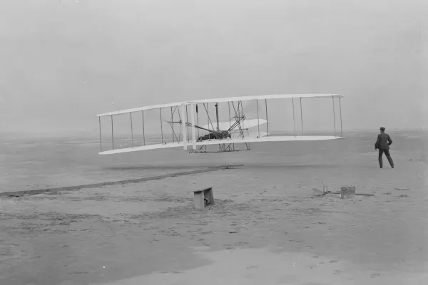
Wright Brothers National Memorial
National Memorial
Wind, sand, and a dream of flight brought Wilbur and Orville Wright to Kitty Hawk, North Carolina where, after four years of scientific experimentation, they achieved the first successful airplane fli...
Park data from the National Park Service API. Alerts update every 2 hours.
More Details
What kind of drive is this?
This route is predominantly highway-focused, with 84% of the drive utilizing major roadways. You'll spend a significant portion of your time on US 64, including the longest stretch of 67.3 miles without a major change in road type. The drive offers a consistent highway experience, with a primary focus on efficient travel rather than varied scenery. Expect a steady pace as you navigate through the North Carolina landscape.
84% highway — fuel and pacing are the main things to plan.
21 navigation steps total — most of the decisions cluster near the start and finish.
Longest single stretch: 67.3 mi on US 64.
How Hard Is This Drive?
5/10
This is a straightforward highway drive that stays mostly on US 64 and US 13. You will hit about 11 points where you need to pay attention to lane position or signs. The trickiest moment comes early in the drive near East Soundside Road.
Driving Effort5/10
Moderate - straightforward overall, but long enough or busy enough to require pacing
Balances navigation complexity with total wheel time.
This drive requires moderate attention. Across 196.3 miles you will encounter 11 spots where lane choice or exit timing matters. Not difficult for experienced highway drivers, but worth previewing the tricky sections before you go.
Where does it get tricky?
The main spots that need attention: near the start (East Soundside Road): Navigation decision point; at 26 miles (US 64): Highway fork - watch signs carefully. Lane positioning matters here; at 189.6 miles: Exit ramp - move to the correct lane early. Lane positioning matters here. Multiple destination signs - pick the right one.
Who Is This Route For?
Weekend Trip
Doable as a same-day drive at 4h 1m. Total distance: 196.3 miles.
Family Friendly
Moderate complexity with 1 natural rest stops along the way.
Solo Traveler
4h 1m drive, comfortable solo distance.
First-Time Driver
Mostly highway driving (84%). Some complex stretches to watch for.
Frequently Asked Questions
The longest stretch is about 67.3 miles on US 64. The full list of main roads is in the Roads section above.
We did not find dedicated rest areas on this route. For a drive this long, plan bathroom and stretch breaks around gas stations, fast-food stops, or small-town downtowns — check the Nearby Places section for options.
Yes, with realistic expectations. Build in a stop roughly every 2 hours, have snacks and activities ready, and check the Nearby Places tabs for kid-friendly stops along the way.
The main spots that need attention: near the start (East Soundside Road): Navigation decision point; at 26 miles (US 64): Highway fork - watch signs carefully. Lane positioning matters here; at 189.6 miles: Exit ramp - move to the correct lane early. Lane positioning matters here. Multiple destination signs - pick the right one.
Yes — Wright Brothers National Memorial. See the National Parks section for detour distances and tips on detours.
Possible but tiring. At 4.0 hours each way, an in-and-out day trip would put you behind the wheel for 8.0 hours — manageable with a long break at West Raleigh, NC, but most travelers stay overnight.