Spanning 205.2 miles across the Mountain West, your trip from Missoula to South Browning is a straightforward journey typically taking about 4 hours and 19 minutes. Because of the manageable duration, this route is perfectly suited for a single-day excursion, meaning you won't need to worry about booking overnight lodging along the way. You can expect to spend roughly $33 on fuel, making it a budget-friendly option for your Montana travels. By utilizing a combination of US Route 2, US 93, and MT 35, you will traverse the heart of the region efficiently. Whether you are heading north for business or recreation, this drive provides a reliable connection between these two points in the state.
Trip Pace
Same-day drive is realistic
A same-day return is possible, but it will make for a full day on the road.
Break Rhythm
1 planned break
Plan on a short reset every 3 to 4 hours to stay fresh behind the wheel.
Midpoint
102.6 miles from Missoula, MT
A natural place for your longest stop of the day
, about 2h 14m into the drive
.
Main Roads
Road
Distance
Duration
US Route 2
80 mi
1h 30m
US 93
58.7 mi
1h 11m
MT 35
45 mi
1h 7m
MT 206
9.7 mi
12m
Jeannette Rankin Memorial Highway
8 mi
8m
US 2
1.7 mi
2m
North Orange Street
0.6 mi
1m
Southwest Boundary Street
0.5 mi
2m
Longest stretch:
US Route 2
— 80 mi, about 1h 30m
Turn-by-Turn Driving Directions
Step-by-step road directions between Missoula, MT and South Browning, MT.
1
Start on North Higgins Avenue
19 ft·4 sec·North Higgins Avenue
2
Turn right onto I 90 Bus
0.2 mi·26 sec·West Broadway Street
3
Turn right onto US 93 Bus
0.5 mi·1 min·North Orange Street
4
Enter roundabout onto US 93 Bus
110 ft·2 sec·North Orange Street
5
Continue on US 93 Bus
278 ft·4 sec·North Orange Street
6
Take the ramp
184 ft·4 sec
7
Continue on this road
0.2 mi·22 sec·this road
8
Merge onto I 90; MT 200
8.0 mi·8 min·Jeannette Rankin Memorial Highway
9
Take the exit onto US 93; MT 200
0.2 mi·24 sec·US 93; MT 200
Toward US 93 North, MT 200 West: Kalispell
10
Keep slight right at fork onto US 93; MT 200
58 mi·1 hr 10 min·US 93; MT 200
Toward US 93 North, MT 200 West: Kalispell
11
Turn right onto MT 35
45 mi·1 hr 7 min·MT 35
Use the straight lane.
12
Continue on MT 35
200 ft·6 sec·MT 35
Use the straight lane.
13
Turn right onto MT 206
9.7 mi·12 min·MT 206
Use the right lane.
14
At end of road, turn right onto US 2
1.7 mi·2 min·US 2
15
Continue on US 2
80 mi·1 hr 30 min·US Route 2
16
Turn right onto 1st Avenue Southwest
0.2 mi·47 sec·1st Avenue Southwest
17
Turn right onto Southwest Boundary Street
0.5 mi·2 min·Southwest Boundary Street
18
Turn left onto 8th Avenue Southwest
452 ft·21 sec·8th Avenue Southwest
19
Turn right onto Owl Eyes Road
385 ft·16 sec·Owl Eyes Road
20
Continue on Mountain Chief Road
0.2 mi·47 sec·Mountain Chief Road
21
Arrive at destination
Mountain Chief Road
Trip Plan
Planning your departure for the morning hours is your best bet to ensure you arrive in South Browning with plenty of daylight left. Given the 4-hour and 19-minute duration, you only need to budget for one primary stop to stretch your legs and refresh. Since the route is almost entirely highway-based, take advantage of the flexibility this offers by checking your fuel levels before merging onto the longer 80-mile stretch of US Route 2. Keep in mind that while the drive is straightforward, staying alert during that lengthy, uninterrupted highway portion is key to a comfortable trip. Use your single planned stop strategically to break up the monotony of the high-speed transit sections.
Morning Departure
An early start around 7-8 AM gets you there with plenty of daylight left.
Evening Departure
A late afternoon start means arriving after dark. Morning is better.
You can normally do this drive in one day.
Plan roughly 1 meaningful break for fuel, food, and rest.
The halfway point lands around 102.6 miles from Missoula, MT, or about 2h 14m into the drive.
The longest continuous stretch on this route runs about 80 miles.
This is a comfortable same-day trip.
Departure
Before you leave
Start with fuel, water, and navigation already sorted so the first hour feels easy.
First stop
Around 45 miles or 54m in
Use this first pause for coffee, a restroom break, and a quick traffic check ahead.
Halfway reset
Around 102.6 miles or 2h 14m in
This is the best place for your longest stop, a real meal, and a full fuel check.
Final approach
Final hour starts around 3h 34m
Traffic, exits, and arrival timing usually matter more near South Browning, MT than in the middle of the route.
Before You Leave
+
Open the route before leaving Missoula, MT so your first major turns are already loaded.
+
Leave with enough water and a charging cable within reach, not packed away.
+
Check your fuel range against the first long segment, especially if you are starting outside city service areas.
Day 1
Settle into the route from Missoula, MT
This is one driving day of about 205.2 miles and 4h 19m.
Your first comfortable stop window is around 45 miles from Missoula, MT.
This route can stay practical as a one-day drive if traffic stays reasonable.
Plan about 1 real break rather than only quick fuel stops.
The longest stretch is on US Route 2 for about 80 miles.
Where to Stop
Rest stops, refuel points, and overnight suggestions along this route.
Place data sourced from public business listings. Hours and availability may vary.
Heads-up: tricky spots
5 of 14
5 decision points cluster between mile 0 and 67.7 — GPS handles the exact turns, but know they're coming. Your lane choice matters more than the turn itself.
5
0 mi into trip|~0m in|I 90 Bus / West Broadway Street
Turn right onto I 90 Bus / West Broadway Street
Navigation decision point
5
0.7 mi into trip|~1m in|US 93 Bus / North Orange Street
Enter roundabout onto US 93 Bus / North Orange Street
Roundabout - know your exit number before entering
5
9 mi into trip|~10m in|US 93; MT 200
Take the exit onto US 93; MT 200 toward US 93 North, MT 200 West: Kalispell
Exit ramp - move to the correct lane early. Multiple destination signs - pick the right one
Toward US 93 North, MT 200 West: Kalispell
6
9.2 mi into trip|~11m in|US 93; MT 200
Keep slight right at fork onto US 93; MT 200 toward US 93 North, MT 200 West: Kalispell
Highway fork - watch signs carefully. Multiple destination signs - pick the right one
Toward US 93 North, MT 200 West: Kalispell
6
67.7 mi into trip|~1h 22m in|MT 35
Turn right onto MT 35
Lane positioning matters here
Use the straight lane.
Fuel & Cost
Regular Gas
$31.98 one way
$63.97 round trip
$3.96/gal25.4 MPG avg72 kg CO2
Fuel Type
$/gal
One Way
Round Trip
midgrade
$4.17
$33.71
$67.43
premium
$4.47
$36.14
$72.29
diesel
$4.80
$38.75
$77.49
No toll roads detected on this route.
Estimated Trip Cost (one way, 1 person)
Fuel
$32
Meals
$25–$50
Total
$57–$82
Rough estimate based on US averages. Hotel $80–$140/night, meals $25–$50/day.
Estimated CO2 emission: 71.8 kg one way.
Prices: EIA weekly data, 2026-07-13.
EV Charging Along Route
7 DC fast chargers
· Coverage: excellent
Missoula, MT - Highway 93 North - Tesla Supercharger
Station data from NREL Alternative Fuel Stations database.
Driving Electric?
About $22 in charging
· 0 stops
· 67% less CO2
Vehicle Type
kWh
Stops
DC Fast
Home Charge
Average EV
61.6
0
$21.55
$9.85
Efficient EV
51.3
0
$17.96
$8.21
EV Truck/SUV
82.1
1
$28.73
$13.13
Gas CO2
72 kg
EV CO2
24 kg (67% less)
This trip is well within single-charge range for most EVs. No charging stops needed if you start fully charged.
DC fast charging avg $0.35/kWh. Home charging avg $0.16/kWh. US grid CO2: 0.39 kg/kWh.
Travel Intel
Current conditions at both ends of the drive.
Forecast as of Jul 19, 2026
Origin
Missoula, MT
Night
in Missoula on Saturday
Local time
9:07 PM
MDT
Current temp
58°F
Areas Of Smoke
W 0 to 7 mph24% chanceLive forecast
Special Weather Statement
Special Weather Statement issued July 18 at 7:14PM MDT by NWS Great Falls MT
Special Weather Statement
Special Weather Statement issued July 18 at 7:09PM MDT by NWS Great Falls MT
Destination
South Browning, MT
Night
in South Browning on Saturday
Local time
9:07 PM
MDT
Current temp
57°F
Mostly Clear
WSW 8 to 17 mph2% chanceLive forecast
Special Weather Statement
Special Weather Statement issued July 18 at 7:14PM MDT by NWS Great Falls MT
Special Weather Statement
Special Weather Statement issued July 18 at 7:09PM MDT by NWS Great Falls MT
Seasonal Notes
Summer travel usually means heavier construction, hotter rest stops, and busier weekend traffic around major cities.
Winter travel shortens daylight, so a route that looks manageable on paper can feel much longer after dark.
Holiday weekends tend to make both departure and arrival windows slower than the raw route time suggests.
Time zone
Same local time
Origin and destination are on the same clock, so arrival timing is easier to judge at a glance.
Temperature spread
1 degrees cooler at arrival
A meaningful temperature swing is a good cue to rethink layers, water, and how soon you want to arrive.
Road read
4h 19m on the road
An early start around 7-8 AM gets you there with plenty of daylight left.
Weather data from the National Weather Service. Conditions may change; check closer to your travel date.
National Parks Near This Route
Worth a detour if your schedule allows.
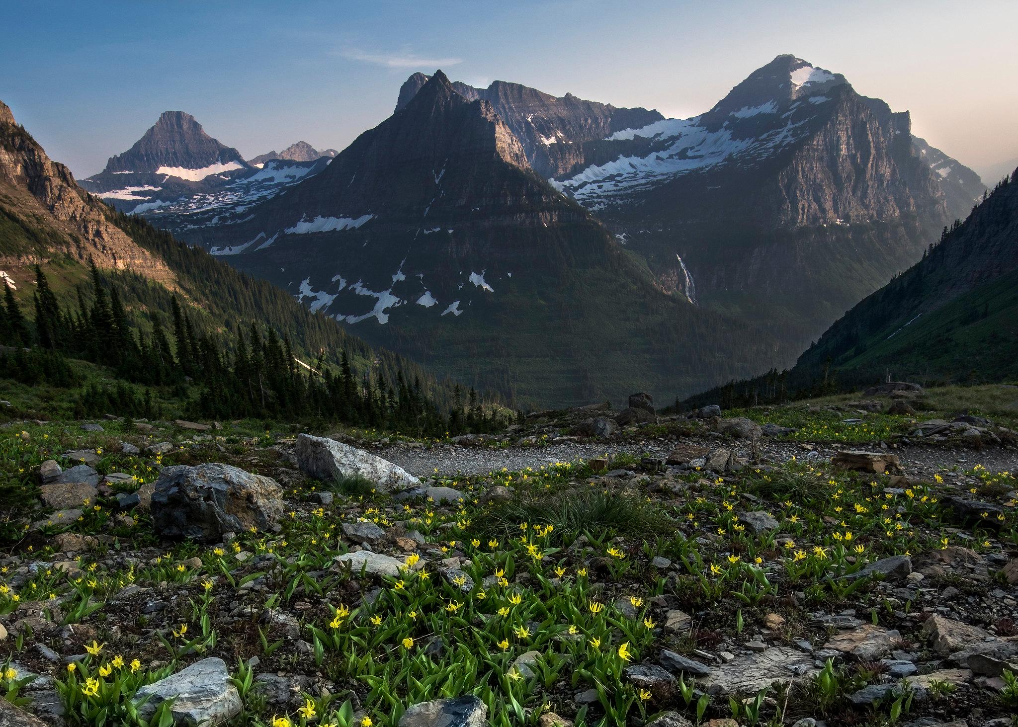
Glacier National Park
National Park
A showcase of melting glaciers, alpine meadows, carved valleys, and spectacular lakes. With over 700 miles of trails, Glacier is a paradise for adventurous visitors seeking a landscape steeped in huma...
14 mi from route
~35 min detour
$35
near mile 141.5
Park Closure: Going-to-the-Sun Road Seasonal Closure
Park data from the National Park Service API. Alerts update every 2 hours.
More Details
What kind of drive is this?
This trip is heavily highway-focused, with 95% of your travel occurring on major thoroughfares. You will experience a mix of road types, but the consistency of the highway network keeps the pace steady throughout the 205.2-mile journey. Prepare yourself for an 80-mile stretch on US Route 2, which stands as the longest uninterrupted segment of your drive. While the road is designed for efficiency, the transition between US 93, MT 35, and US 2 keeps the driving experience varied. You can count on a predictable rhythm behind the wheel, allowing you to focus on the road as you navigate the Mountain West landscape.
95% highway — fuel and pacing are the main things to plan.
21 navigation steps total — most of the decisions cluster near the start and finish.
Longest single stretch: 80 mi on US Route 2.
How Hard Is This Drive?
4/10
This is a straightforward highway drive that stays mostly on US Route 2 and US 93. There are only a few real navigation decisions along the way. The trickiest moment comes early in the drive near I 90 Bus / West Broadway Street.
Driving Effort4/10
Easy - simple navigation with a manageable amount of wheel time
Balances navigation complexity with total wheel time.
This is a straightforward 4h 19m drive. You will face about 14 decision points, but nothing that requires special attention if you follow navigation.
Where does it get tricky?
The main spots that need attention: near the start (I 90 Bus / West Broadway Street): Navigation decision point; at 0.7 miles (US 93 Bus / North Orange Street): Roundabout - know your exit number before entering; at 9 miles (US 93; MT 200): Exit ramp - move to the correct lane early. Multiple destination signs - pick the right one.
Elevation Profile
Gently rolling terrain
4,785 ft2,842 ft
Total Climb
2,695 ft
Total Descent
1,507 ft
Highest Point
4,785 ft
~190.5 mi in
Elevation Range
1,944 ft
Notable High Points
3,833 ft at ~14.7 miles+624 ft prominence
4,785 ft at ~190.5 miles+261 ft prominence
Detours Along the Way
Tagged by where each one fits in your drive — first break, midpoint, final stretch.
Missoula is a medium size city in Western Montana with a population of about 73,000 (2020). The hub of five valleys in the northwest region of the state, or Glacier Country, the town boasts the University of Montana, the Rattlesnake Wilderness Area, and a multitude of recreational opportunities, along with an active and colorful downtown.
Top landmarks
•Fort Missoula
•Gleim Building — building in Missoula, Montana, US
•Masonic Lodge — Masonic lodge in Missoula, Montanna
The longest stretch is about 80 miles on US Route 2. The full list of main roads is in the Roads section above.
Yes — we found about 6 rest areas or service plazas within a short detour of the route (from OpenStreetMap). See the Rest Stops tab under Nearby Places for locations and mile markers. Plan to stretch, use the bathroom, and top off fluids every 2–3 hours on longer drives.
Yes, with realistic expectations. Build in a stop roughly every 2 hours, have snacks and activities ready, and check the Nearby Places tabs for kid-friendly stops along the way.
Mostly yes along the main roads, but rural stretches through MT can have sparse or no coverage. Before you leave, download offline Google Maps or Apple Maps for the route, and consider downloading music or podcasts instead of streaming. If you depend on data for navigation, keep a paper backup of the turn-by-turn directions.
The main spots that need attention: near the start (I 90 Bus / West Broadway Street): Navigation decision point; at 0.7 miles (US 93 Bus / North Orange Street): Roundabout - know your exit number before entering; at 9 miles (US 93; MT 200): Exit ramp - move to the correct lane early. Multiple destination signs - pick the right one.
Yes — Glacier National Park. See the National Parks section for detour distances and tips on detours.
Possible but tiring. At 4.3 hours each way, an in-and-out day trip would put you behind the wheel for 8.6 hours — manageable with a long break at South Browning, MT, but most travelers stay overnight.