Origin
Manitou Springs, CO
Late night in Manitou Springs on Sunday
Local time
4:23 AM
MDT
Current temp
64°F
Unavailable
Live forecast
Compiled and reviewed by the US Trip Planner planning team at COD Solutions Oy · Last reviewed Apr 19, 2026 · Editorial standards
Drive Time
2h 17m
Distance
54.4 mi
88 km
Drive Score
9/10
Great drive
Same Day?
Yes, doable
Fuel Cost
$8
one way
EV Charging
Unknown
Estimated drive times based on typical traffic patterns. Actual times may vary with weather, construction, and real-time conditions.

Manitou Springs, CO
Wikimedia Commons

Midway, CO
Stephen Leonardi
Manitou Springs to Midway is 54.4 miles and takes about 2h 17m via South State Highway 67 and US 24 Business, with a fuel budget near $8 and enough daylight to finish in a day. This trip stays within Colorado, connecting two points in the Mountain West region. It offers a mixed drive experience, perfect for a single-day excursion. You'll find this route provides a straightforward journey without requiring an overnight stay, making it a convenient option for a quick getaway.
Trip Pace
Same-day drive is realistic
A same-day return is realistic if you keep stops short.
Midpoint
27.2 miles from Manitou Springs, CO
A natural place for your longest stop of the day , about 43m into the drive .
| Road | Distance | Duration |
|---|---|---|
| South State Highway 67 | 13.3 mi | 22m |
| US 24 Business | 12.6 mi | 19m |
| Gold Camp Road | 7.5 mi | 28m |
| US 24 | 6.5 mi | 9m |
| Forest Road | 3.9 mi | 15m |
| Seven Lakes Road | 3.7 mi | 15m |
| County Road 81 | 3.1 mi | 5m |
| City Water Department Roads | 2.2 mi | 14m |
Step-by-step road directions between Manitou Springs, CO and Midway, CO.
Start on this road
Turn right onto Cañon Avenue
Turn left onto Park Avenue
Turn straight onto US 24 Business
Enter roundabout
Continue
Turn straight onto US 24 Business
Take the ramp onto US 24 Business
Keep slight right at fork onto US 24; CO 67
Turn left onto CO 67
Turn left onto CR 81
Turn left onto CR 8
Turn left onto Seven Lakes Road
Continue on City Water Department Roads
Continue on Forest Road
Turn straight
Arrive at destination
Given the relatively short distance of 54.4 miles and a drive time of just over two hours, this trip offers flexibility. You can depart anytime, but an early start allows for a leisurely pace. Plan for potential stops along the way, especially since there are no designated stops listed; you'll want to be mindful of fuel, with an estimated cost of $8. Keep an eye on your fuel gauge, as the longest stretch without a change in main road is 13.3 miles on South State Highway 67.
Morning Departure
Leave by 9 AM and you'll arrive before lunch.
Evening Departure
Even a 4 PM departure gets you there before dark in summer.
This is a comfortable same-day trip.
Departure
Before you leave
Start with fuel, water, and navigation already sorted so the first hour feels easy.
First stop
Around 12 miles or 19m in
Use this first pause for coffee, a restroom break, and a quick traffic check ahead.
Halfway reset
Around 27.2 miles or 43m in
This is the best place for your longest stop, a real meal, and a full fuel check.
Final approach
Final hour starts around 1h 38m
Traffic, exits, and arrival timing usually matter more near Midway, CO than in the middle of the route.
Open the route before leaving Manitou Springs, CO so your first major turns are already loaded.
Leave with enough water and a charging cable within reach, not packed away.
Check your fuel range against the first long segment, especially if you are starting outside city service areas.
Day 1
Settle into the route from Manitou Springs, CO
This is one driving day of about 54.4 miles and 2h 17m.
Rest stops, refuel points, and overnight suggestions along this route.

Mid-route town
Meal stop
27 mi into the route
Best for: Lunch, fuel, and a longer reset
This sits close to the middle of the route, so it works well for the longest stop of the day.
A short stop after about 12 miles helps settle the day before fatigue starts building.
The midpoint is around 27.2 miles from Manitou Springs, CO, which is a good place for a longer meal and fuel stop.
These stop ideas are pacing suggestions — the exact town or exit can change with traffic, hotel plans, and fuel range.
5 decision points cluster between mile 0 and 20.1 — GPS handles the exact turns, but know they're coming. Your lane choice matters more than the turn itself.
Turn right onto Cañon Avenue
Navigation decision point
Turn left onto Park Avenue
Navigation decision point
Enter roundabout
Roundabout - know your exit number before entering
Keep slight right at fork onto US 24; CO 67
Highway fork - watch signs carefully
Turn left onto CO 67 / South State Highway 67
Lane positioning matters here
Regular Gas
$8.20 one way
$16.39 round trip
| Fuel Type | $/gal | One Way | Round Trip |
|---|---|---|---|
| midgrade | $4.05 | $8.68 | $17.36 |
| premium | $4.39 | $9.41 | $18.82 |
| diesel | $5.61 | $12.01 | $24.02 |
No toll roads detected on this route.
Estimated Trip Cost (one way, 1 person)
Fuel
$8
Meals
$25–$50
Total
$33–$58
Rough estimate based on US averages. Hotel $80–$140/night, meals $25–$50/day.
Estimated CO2 emission: 19 kg one way. Prices: EIA weekly data, 2026-04-13.
Driving Electric?
About $6 in charging · 0 stops · 68% less CO2
| Vehicle Type | kWh | Stops | DC Fast | Home Charge |
|---|---|---|---|---|
| Average EV | 16.3 | 0 | $5.71 | $2.61 |
| Efficient EV | 13.6 | 0 | $4.76 | $2.18 |
| EV Truck/SUV | 21.8 | 0 | $7.62 | $3.48 |
Gas CO2
19 kg
EV CO2
6 kg (68% less)
This trip is well within single-charge range for most EVs. No charging stops needed if you start fully charged.
DC fast charging avg $0.35/kWh. Home charging avg $0.16/kWh. US grid CO2: 0.39 kg/kWh.
Current conditions at both ends of the drive.
Origin
Late night in Manitou Springs on Sunday
Local time
4:23 AM
MDT
Current temp
64°F
Unavailable
Destination
Late night in Midway on Sunday
Local time
4:23 AM
MDT
Current temp
42°F
Unavailable
Seasonal Notes
Summer travel usually means heavier construction, hotter rest stops, and busier weekend traffic around major cities.
Winter travel shortens daylight, so a route that looks manageable on paper can feel much longer after dark.
Holiday weekends tend to make both departure and arrival windows slower than the raw route time suggests.
Time zone
Origin and destination are on the same clock, so arrival timing is easier to judge at a glance.
Temperature spread
A meaningful temperature swing is a good cue to rethink layers, water, and how soon you want to arrive.
Road read
Use the two city cards together: check the sky where you start, then compare it with the local time and temperature at arrival.
Weather data from the National Weather Service. Conditions may change; check closer to your travel date.
Worth a detour if your schedule allows.
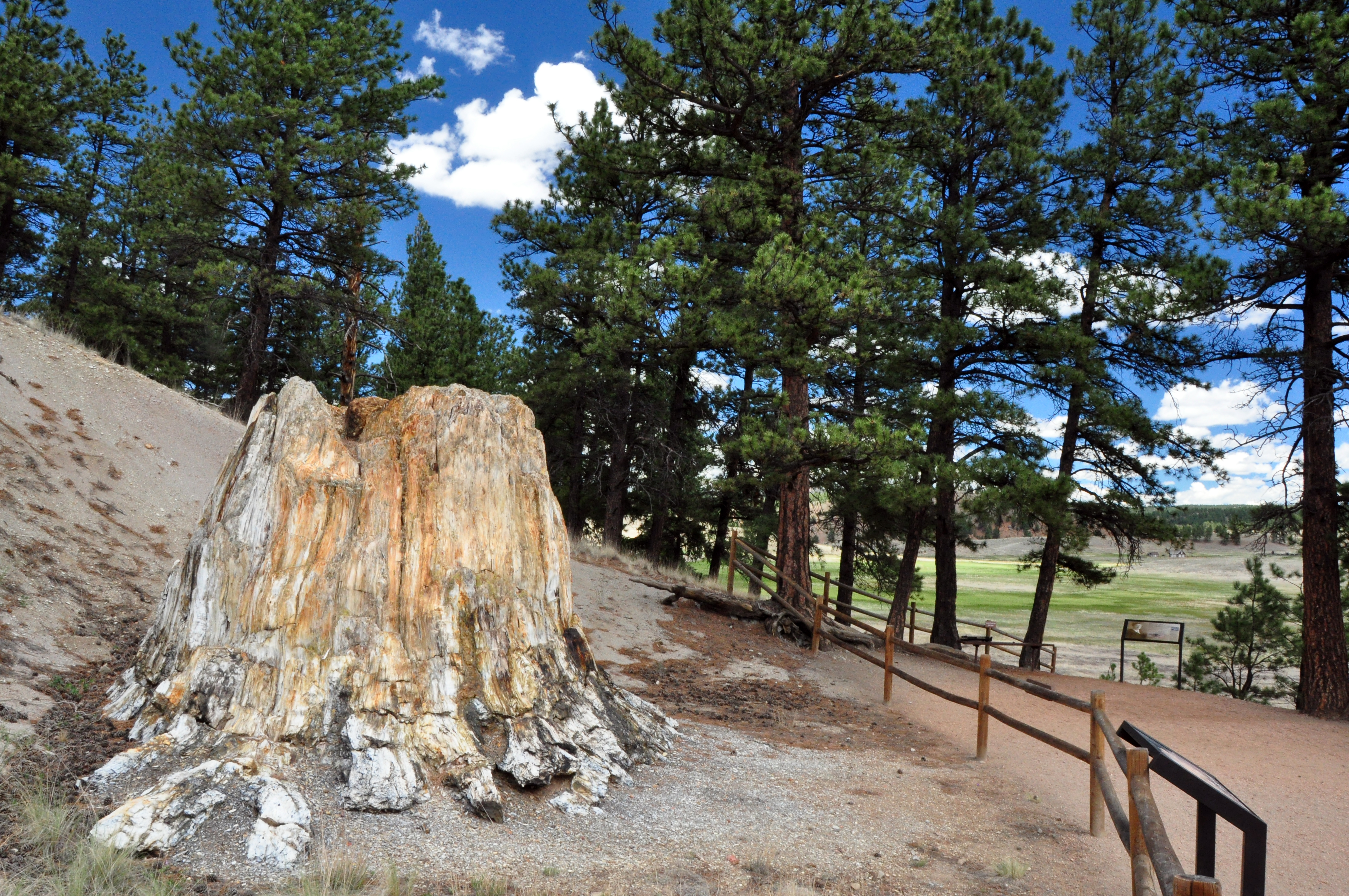
National Monument
Beneath a grassy mountain valley in central Colorado lies one of the richest and most diverse fossil deposits in the world. Petrified redwood stumps up to 14 feet wide and thousands of detailed fossil...
Park data from the National Park Service API. Alerts update every 2 hours.
This route features a mixed drive profile, with about 60% of the journey on highways. You'll encounter stretches on South State Highway 67, including the longest uninterrupted segment of 13.3 miles. The roads will vary, shifting from wider highway sections to potentially more winding local routes as you progress. Expect a dynamic driving experience that keeps you engaged.
This route mixes highway mileage with some local-road sections near the start or finish. There are only a few real navigation decisions along the way. The trickiest moment comes early in the drive near Cañon Avenue.
Easy - simple navigation with a manageable amount of wheel time
Balances navigation complexity with total wheel time.
This is a straightforward 2h 17m drive. You will face about 9 decision points, but nothing that requires special attention if you follow navigation.
Where does it get tricky?
The main spots that need attention: near the start (Cañon Avenue): Navigation decision point; near the start (Park Avenue): Navigation decision point; at 0.5 miles: Roundabout - know your exit number before entering.
Weekend Trip
Doable as a same-day drive at 2h 17m. Total distance: 54.4 miles.
Family Friendly
Moderate complexity with 0 natural rest stops along the way.
Solo Traveler
2h 17m drive, comfortable solo distance.
First-Time Driver
Mostly highway driving (60%). Straightforward navigation.
Compiled by the US Trip Planner planning team at COD Solutions Oy from open government datasets — OSRM over OpenStreetMap for geometry, EIA for fuel prices, and NPS for national parks. See our methodology for refresh cadence and limitations.
Was this helpful?
Thanks for your feedback!
Your tip has been submitted. Thanks!
/500
Recent Tips
·
Explore more options from Manitou Springs, CO or browse trips ending in Midway, CO.
Looking for more statewide routes? Browse CO road trips.