Maine, NC to Beaufort, NC is 275 miles and takes about 5h 37m via US 421 and I-40, with a fuel budget near $43 and enough daylight to finish in a day. This trip stays within North Carolina, traversing the Southeast region. It's a primarily highway-focused drive, making it a straightforward journey for a single day. Given the relatively short duration and consistent road type, you'll find this route to be an efficient way to get from point A to point B.
Trip Pace
Same-day drive is realistic
A same-day return is possible, but it will make for a full day on the road.
Break Rhythm
1 planned break
Plan on a short reset every 3 to 4 hours to stay fresh behind the wheel.
Midpoint
137.5 miles from Maine, NC
A natural place for your longest stop of the day
, about 2h 45m into the drive
.
Main Roads
Road
Distance
Duration
US 421
38.8 mi
46m
I 40
37.5 mi
42m
Freedom Memorial Bridge
36.9 mi
52m
East New Bern Road
33.4 mi
36m
US 64
32 mi
42m
Triangle Expressway
22 mi
23m
US 70
21.2 mi
25m
Goldsboro Bypass
19.8 mi
21m
Longest stretch:
US 421
— 38.8 mi, about 46m
Turn-by-Turn Driving Directions
Step-by-step road directions between Maine, NC and Beaufort, NC.
1
Start on Oak Grove Church Road
48 ft·3 sec·Oak Grove Church Road
2
Turn right onto US 158
1.8 mi·2 min·US 158
3
Turn left onto US 158
200 ft·5 sec·US 158
4
Turn straight onto Farmington Road
0.3 mi·36 sec·Farmington Road
5
Enter roundabout
64 ft·2 sec
6
Continue
0.2 mi·27 sec
7
Merge onto I 40
37 mi·42 min·I 40
Use the straight / slight right lanes.
8
Keep slight left at fork onto US 421
12 mi·13 min·US 421
Toward I 73 South, US 421 South: Asheboro, DurhamUse the straight / slight right lanes.
9
Take the exit onto US 421
0.2 mi·27 sec·US 421
Exit 126Toward US 421: SanfordUse the slight right lane.
10
Keep slight right at fork onto US 421
26 mi·32 min·US 421
Exit 126AToward US 421 South: SanfordUse the straight / slight right lanes.
11
Take the exit
0.3 mi·42 sec
Exit 171Toward US 64: Siler City, PittsboroUse the slight right lane.
12
Turn left onto US 64
11 mi·15 min·US 64
Use the straight lane.
13
Keep slight left at fork onto US 64
21 mi·27 min·US 64
Use the straight lane.
14
Take the exit
0.5 mi·1 min
Toward NC 540 Toll SouthUse the right lane.
15
Merge onto NC 540 Toll
22 mi·23 min·Triangle Expressway
16
Keep slight left at fork
0.3 mi·40 sec
17
Keep slight right at fork
0.5 mi·1 min
Toward I 42 East: Smithfield
18
Merge onto I 42
8.7 mi·9 min·Clayton Bypass Scenic Byway
19
Continue on US 70
7.6 mi·9 min·US 70
20
Keep slight left at fork onto US 70 BYP
14 mi·19 min·US 70 BYP
Use the straight lane.
21
Continue on US 70
2.0 mi·2 min·US 70
Use the right lane.
22
Continue on I 42
20 mi·21 min·Goldsboro Bypass
Use the straight / right lanes.
23
Continue on US 70
11 mi·13 min·US 70
Use the straight / slight right lanes.
24
Turn straight onto US 70; US 258
3.1 mi·4 min·West New Bern Road
Use the left / straight lanes.
25
Continue on US 70; NC 58
33 mi·36 min·East New Bern Road
Use the straight lane.
26
Keep slight left at fork onto US 70
37 mi·52 min·Freedom Memorial Bridge
Use the straight lane.
27
Continue on US 70
2.3 mi·3 min·Arendell Street
Use the straight lane.
28
Continue on US 70
0.4 mi·55 sec·Grayden Paul Bridge
Use the straight lane.
29
Turn right onto US 70 Business
0.6 mi·1 min·Turner Street
Use the right lane.
30
Turn left onto Ann Street
298 ft·10 sec·Ann Street
31
Arrive at destination
Ann Street
Trip Plan
For this 275-mile drive, starting in the morning will give you ample time to reach Beaufort, NC, well before evening. With a duration of just over 5 hours, you won't need to plan for overnight stays, offering flexibility. The longest stretch without a major turn is 38.8 miles on US 421, so plan your fuel stops accordingly before you hit that point. Consider a brief stop around the halfway mark to stretch your legs and stay refreshed for the remainder of the journey.
Morning Departure
An early start around 7-8 AM gets you there with plenty of daylight left.
Evening Departure
A late afternoon start means arriving after dark. Morning is better.
You can normally do this drive in one day.
Plan roughly 1 meaningful break for fuel, food, and rest.
The halfway point lands around 137.5 miles from Maine, NC, or about 2h 45m into the drive.
The longest continuous stretch on this route runs about 38.8 miles.
This is a comfortable same-day trip.
Departure
Before you leave
Start with fuel, water, and navigation already sorted so the first hour feels easy.
First stop
Around 61 miles or 1h 11m in
Use this first pause for coffee, a restroom break, and a quick traffic check ahead.
Halfway reset
Around 137.5 miles or 2h 45m in
This is the best place for your longest stop, a real meal, and a full fuel check.
Final approach
Final hour starts around 4h 28m
Traffic, exits, and arrival timing usually matter more near Beaufort, NC than in the middle of the route.
Before You Leave
+
Open the route before leaving Maine, NC so your first major turns are already loaded.
+
Leave with enough water and a charging cable within reach, not packed away.
+
Check your fuel range against the first long segment, especially if you are starting outside city service areas.
Day 1
Settle into the route from Maine, NC
This is one driving day of about 275 miles and 5h 37m.
Your first comfortable stop window is around 61 miles from Maine, NC.
This route can stay practical as a one-day drive if traffic stays reasonable.
Plan about 1 real break rather than only quick fuel stops.
The longest stretch is on US 421 for about 38.8 miles.
Where to Stop
Rest stops, refuel points, and overnight suggestions along this route.
Place data sourced from public business listings. Hours and availability may vary.
Heads-up: tricky spots
5 of 21
5 decision points cluster between mile 39.8 and 78.8 — GPS handles the exact turns, but know they're coming. Your lane choice matters more than the turn itself.
8
39.8 mi into trip|~46m in|US 421
Keep slight left at fork onto US 421 toward I 73 South, US 421 South: Asheboro, Durham
Highway fork - watch signs carefully. Lane positioning matters here. Multiple destination signs - pick the right one
Use the straight / slight right lanes.
Toward I 73 South, US 421 South: Asheboro, Durh...
7
52 mi into trip|~59m in|US 421
Take the exit onto US 421 toward US 421: Sanford
Exit ramp - move to the correct lane early. Lane positioning matters here
Use the slight right lane.
Exit 126
Toward US 421: Sanford
8
52.3 mi into trip|~1h in|US 421
Keep slight right at fork onto US 421 toward US 421 South: Sanford
Highway fork - watch signs carefully. Lane positioning matters here
Use the straight / slight right lanes.
Exit 126A
Toward US 421 South: Sanford
8
78.6 mi into trip|~1h 32m in
Take the exit toward US 64: Siler City, Pittsboro
Exit ramp - move to the correct lane early. Lane positioning matters here. Multiple destination signs - pick the right one
Use the slight right lane.
Exit 171
Toward US 64: Siler City, Pittsboro
6
78.8 mi into trip|~1h 33m in|US 64
Turn left onto US 64
Lane positioning matters here
Use the straight lane.
Fuel & Cost
Regular Gas
$40.60 one way
$81.20 round trip
$3.75/gal25.4 MPG avg96 kg CO2
Fuel Type
$/gal
One Way
Round Trip
midgrade
$4.12
$44.62
$89.23
premium
$4.49
$48.63
$97.27
diesel
$4.80
$51.93
$103.85
No toll roads detected on this route.
Estimated Trip Cost (one way, 1 person)
Fuel
$41
Meals
$25–$50
Total
$66–$91
Rough estimate based on US averages. Hotel $80–$140/night, meals $25–$50/day.
Estimated CO2 emission: 96.2 kg one way.
Prices: EIA weekly data, 2026-07-13.
Driving Electric?
About $29 in charging
· 1 stop
· 67% less CO2
Vehicle Type
kWh
Stops
DC Fast
Home Charge
Average EV
82.5
1
$28.88
$13.20
Efficient EV
68.8
0
$24.06
$11.00
EV Truck/SUV
110
1
$38.50
$17.60
Gas CO2
96 kg
EV CO2
32 kg (67% less)
Plan for 1 charging stop. A 30-minute DC fast charge mid-route should be enough to complete the trip comfortably.
DC fast charging avg $0.35/kWh. Home charging avg $0.16/kWh. US grid CO2: 0.39 kg/kWh.
Travel Intel
Current conditions at both ends of the drive.
Forecast as of Jul 18, 2026
Origin
Maine, NC
Late night
in Maine on Sunday
Local time
2:42 AM
EDT
Current temp
73°F
Mostly Cloudy
0 mph5% chanceLive forecast
Beach Hazards Statement
Beach Hazards Statement issued July 17 at 9:15PM EDT until July 18 at 8:00PM EDT by NWS Wilmington NC
Destination
Beaufort, NC
Late night
in Beaufort on Sunday
Local time
2:42 AM
EDT
Current temp
81°F
Partly Cloudy
SW 9 mph2% chanceLive forecast
Beach Hazards Statement
Beach Hazards Statement issued July 17 at 9:15PM EDT until July 18 at 8:00PM EDT by NWS Wilmington NC
Seasonal Notes
Summer travel usually means heavier construction, hotter rest stops, and busier weekend traffic around major cities.
Winter travel shortens daylight, so a route that looks manageable on paper can feel much longer after dark.
Holiday weekends tend to make both departure and arrival windows slower than the raw route time suggests.
Time zone
Same local time
Origin and destination are on the same clock, so arrival timing is easier to judge at a glance.
Temperature spread
8 degrees warmer at arrival
A meaningful temperature swing is a good cue to rethink layers, water, and how soon you want to arrive.
Road read
5h 37m on the road
An early start around 7-8 AM gets you there with plenty of daylight left.
Weather data from the National Weather Service. Conditions may change; check closer to your travel date.
National Parks Near This Route
Worth a detour if your schedule allows.
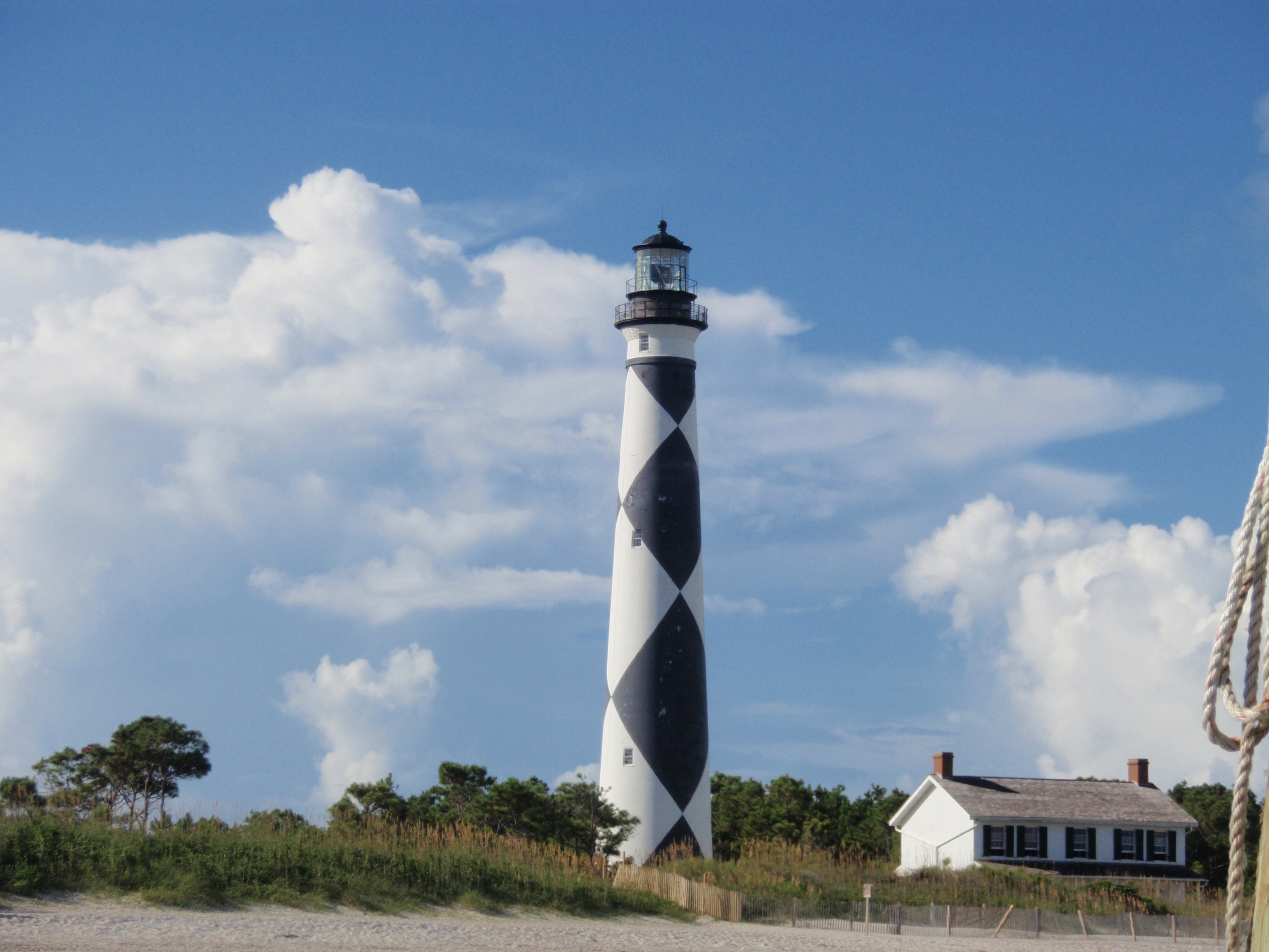
Cape Lookout National Seashore
National Seashore
A boat ride three miles off-shore brings you to the barrier islands of Cape Lookout National Seashore. Horse watching, shelling, fishing, birding, camping, lighthouse climbing, and touring historic vi...
20 mi from route
~49 min detour
Free
near mile 275
Park data from the National Park Service API. Alerts update every 2 hours.
More Details
What kind of drive is this?
This drive is predominantly highway-focused, with 61% of the journey on faster roads. You'll experience stretches of open highway, including a significant 38.8-mile segment on US 421 where you can maintain a steady pace. The route incorporates I-40, offering a typical interstate experience for a portion of the trip. Expect a consistent driving rhythm for most of the 5h 37m duration.
61% highway — fuel and pacing are the main things to plan.
31 navigation steps total — most of the decisions cluster near the start and finish.
Longest single stretch: 38.8 mi on US 421.
How Hard Is This Drive?
9/10
This is a straightforward highway drive that stays mostly on US 421 and I 40. This route has several spots where lane changes, forks, or exits need your full attention. The trickiest moment comes around 39.8 miles in near US 421.
Driving Effort9/10
High effort - long or complex enough to need steady focus all day
Balances navigation complexity with total wheel time.
This is a demanding drive. With 21 significant decision points across 275 miles, you will need to stay alert - especially through interchange areas and urban stretches. Consider splitting it into segments if you are not comfortable with fast highway navigation.
Where does it get tricky?
The main spots that need attention: at 39.8 miles (US 421): Highway fork - watch signs carefully. Lane positioning matters here. Multiple destination signs - pick the right one; at 52 miles (US 421): Exit ramp - move to the correct lane early. Lane positioning matters here; at 52.3 miles (US 421): Highway fork - watch signs carefully. Lane positioning matters here.
Elevation Profile
Mostly flat terrain
884 ft8 ft
Total Climb
208 ft
Total Descent
996 ft
Highest Point
884 ft
~39.3 mi in
Elevation Range
876 ft
Towns Mentioned on Route Signs
Based on OSRM destination-sign hints, not a full list of every settlement the road passes.
Between Maine, NC and Beaufort, NC, road signs point toward Durham and Pittsboro.
Beaufort is the easternmost town in the Crystal Coast region of North Carolina; the county seat; and the third-oldest town in the state. Established in 1713 on the Newport River, Beaufort was named after Henry Somerset, the Duke of Beaufort. Beaufort's two main claims to fame are its intact historical homes and its connection with the dreaded pirate Blackbeard. The town's name is pronounced differently than that of its South Carolina namesake; this Beaufort is "BO-furt" (IPA ['bou.frt]).
Top landmarks
•Beaufort Historic District — historic district in North Carolina, United States
•Jacob Henry House — building in Beaufort, North Carolina, United States
•Old Burying Ground — cemetery in Beaufort, North Carolina, USA
Doable as a same-day drive at 5h 37m. Total distance: 275 miles.
Family Friendly
Moderate complexity with 1 natural rest stops along the way.
Solo Traveler
5h 37m drive, comfortable solo distance.
Frequently Asked Questions
The longest stretch is about 38.8 miles on US 421. The full list of main roads is in the Roads section above.
Yes — we found about 5 rest areas or service plazas within a short detour of the route (from OpenStreetMap). See the Rest Stops tab under Nearby Places for locations and mile markers. Plan to stretch, use the bathroom, and top off fluids every 2–3 hours on longer drives.
It helps. This route has a higher-than-average number of complex decision points, which get harder in the dark. If the last hour of the trip is on surface roads or mountain grades, aim to arrive at Beaufort, NC before sunset when you can. Check the Trip Plan for departure windows that land you in daylight.
Only with planning. This is a long drive for kids — consider splitting it into two days rather than pushing through. Plan at least 1 meaningful breaks. There are 5 rest areas along the route for bathroom stops.
The main spots that need attention: at 39.8 miles (US 421): Highway fork - watch signs carefully. Lane positioning matters here. Multiple destination signs - pick the right one; at 52 miles (US 421): Exit ramp - move to the correct lane early. Lane positioning matters here; at 52.3 miles (US 421): Highway fork - watch signs carefully. Lane positioning matters here.
Yes — Cape Lookout National Seashore. See the National Parks section for detour distances and tips on detours.
Not recommended in a single day. At 5.6 hours each way, a round trip means 11.2 hours of driving — that is an unsafe level of fatigue for most drivers. Plan at least one night at Beaufort, NC before the return drive.