Lodge Grass to Fort Smith is 65.6 miles and takes about 1h 40m via Secondary State Highway 313 and I 90, with a fuel budget near $10 and enough daylight to finish in a day. This short drive stays within the Mountain West region, specifically within Montana. Expect a straightforward journey that's easily manageable in a single day, making it a convenient option if you're looking for a quick connection between these two points. The route is primarily highway-focused, so it's less about leisurely sightseeing and more about efficient travel. Consider this for a practical transit rather than an extensive scenic tour.
Trip Pace
Same-day drive is realistic
A same-day return is realistic if you keep stops short.
Midpoint
32.8 miles from Lodge Grass, MT
A natural place for your longest stop of the day
, about 41m into the drive
.
Main Roads
Road
Distance
Duration
Secondary State Highway 313
32 mi
56m
I 90
20.9 mi
19m
Crow-Saint Xavier Road
9.6 mi
16m
Route 211
0.7 mi
2m
Longest stretch:
Secondary State Highway 313
— 32 mi, about 56m
Turn-by-Turn Driving Directions
Step-by-step road directions between Lodge Grass, MT and Fort Smith, MT.
1
Start on this road
1.0 mi·1 min·this road
2
Take the ramp
0.3 mi·40 sec
3
Merge onto I 90; US 87
21 mi·19 min·I 90; US 87
4
Take the exit
0.2 mi·40 sec
5
Turn left
0.7 mi·1 min
6
At end of road, turn left
510 ft·10 sec
7
Continue on BIA 1
9.6 mi·16 min·Crow-Saint Xavier Road
8
Turn left onto MT 313
3.9 mi·6 min·Secondary State Highway 313
9
Continue on MT 313
9.8 mi·17 min·Secondary State Highway 313
10
Continue on MT 313
18 mi·32 min·Secondary State Highway 313
11
Continue on Route 211
0.7 mi·2 min·Route 211
12
Turn left
66 ft·2 sec
13
Arrive at destination
Trip Plan
With a total duration of just 1h 40m, this is a trip you can easily complete in one day, offering flexibility in your departure time. There are no designated stops listed, so plan your own breaks as needed, perhaps after the 32-mile stretch on Secondary State Highway 313. Given the relatively low fuel cost of around $10, you likely won't need to worry about frequent refueling, but it's always wise to top off before you leave Lodge Grass. Keep an eye on road conditions, especially if traveling during inclement weather seasons, as Montana highways can be unpredictable. This is a straightforward transit, so focus on getting going and arriving at your destination efficiently.
Morning Departure
Leave by 9 AM and you'll arrive before lunch.
Evening Departure
Even a 4 PM departure gets you there before dark in summer.
You can normally do this drive in one day.
You may only need one short stretch break if traffic stays light.
The halfway point lands around 32.8 miles from Lodge Grass, MT, or about 41m into the drive.
The longest continuous stretch on this route runs about 32 miles.
This is a comfortable same-day trip.
Departure
Before you leave
Start with fuel, water, and navigation already sorted so the first hour feels easy.
First stop
Around 14 miles or 14m in
Use this first pause for coffee, a restroom break, and a quick traffic check ahead.
Halfway reset
Around 32.8 miles or 41m in
This is the best place for your longest stop, a real meal, and a full fuel check.
Final approach
Final hour starts around 1h 21m
Traffic, exits, and arrival timing usually matter more near Fort Smith, MT than in the middle of the route.
Before You Leave
+
Open the route before leaving Lodge Grass, MT so your first major turns are already loaded.
Day 1
Settle into the route from Lodge Grass, MT
This is one driving day of about 65.6 miles and 1h 40m.
Your first comfortable stop window is around 14 miles from Lodge Grass, MT.
This route can stay practical as a one-day drive if traffic stays reasonable.
The longest stretch is on Secondary State Highway 313 for about 32 miles.
Stops Along Your Drive
Picked by where they fit in your drive — first break, midpoint reset, final stretch.
Place data sourced from public business listings. Hours and availability may vary.
Heads-up: tricky spots
5 of 7
5 decision points cluster between mile 1 and 65.6 — GPS handles the exact turns, but know they're coming. Your lane choice matters more than the turn itself.
4
1 mi into trip|~1m in
Take the ramp
Navigation decision point
4
22.4 mi into trip|~22m in
Turn left
Navigation decision point
5
23.2 mi into trip|~24m in
At end of road, turn left
Navigation decision point
4
32.9 mi into trip|~41m in|MT 313 / Secondary State Highway 313
Turn left onto MT 313 / Secondary State Highway 313
Navigation decision point
4
65.6 mi into trip|~1h 40m in
Turn left
Navigation decision point
Fuel & Cost
Regular Gas
$11.53 one way
$23.06 round trip
$4.47/gal25.4 MPG avg23 kg CO2
Fuel Type
$/gal
One Way
Round Trip
midgrade
$4.67
$12.06
$24.12
premium
$4.99
$12.89
$25.78
diesel
$5.35
$13.82
$27.63
No toll roads detected on this route.
Estimated Trip Cost (one way, 1 person)
Fuel
$12
Meals
$25–$50
Total
$37–$62
Rough estimate based on US averages. Hotel $80–$140/night, meals $25–$50/day.
Estimated CO2 emission: 23 kg one way.
Prices: EIA weekly data, 2026-06-01.
Driving Electric?
About $7 in charging
· 0 stops
· 65% less CO2
Vehicle Type
kWh
Stops
DC Fast
Home Charge
Average EV
19.7
0
$6.89
$3.15
Efficient EV
16.4
0
$5.74
$2.62
EV Truck/SUV
26.2
0
$9.18
$4.20
Gas CO2
23 kg
EV CO2
8 kg (65% less)
This trip is well within single-charge range for most EVs. No charging stops needed if you start fully charged.
DC fast charging avg $0.35/kWh. Home charging avg $0.16/kWh. US grid CO2: 0.39 kg/kWh.
Travel Intel
Current conditions at both ends of the drive.
Forecast as of Jun 3, 2026
Origin
Lodge Grass, MT
Afternoon
in Lodge Grass on Wednesday
Local time
12:58 PM
MDT
Current temp
45°F
Slight Chance Rain Showers then Patchy Fog
N 3 to 10 mph18% chanceLive forecast
Destination
Fort Smith, MT
Afternoon
in Fort Smith on Wednesday
Local time
12:58 PM
MDT
Current temp
47°F
Partly Cloudy
ENE 2 to 8 mph12% chanceLive forecast
Seasonal Notes
Summer travel usually means heavier construction, hotter rest stops, and busier weekend traffic around major cities.
Winter travel shortens daylight, so a route that looks manageable on paper can feel much longer after dark.
Holiday weekends tend to make both departure and arrival windows slower than the raw route time suggests.
Time zone
Same local time
Origin and destination are on the same clock, so arrival timing is easier to judge at a glance.
Temperature spread
2 degrees warmer at arrival
A meaningful temperature swing is a good cue to rethink layers, water, and how soon you want to arrive.
Road read
1h 40m on the road
The weather snapshot is not static. If you are leaving later, give both cities one more quick forecast check before departure.
Weather data from the National Weather Service. Conditions may change; check closer to your travel date.
National Parks Near This Route
Worth a detour if your schedule allows.
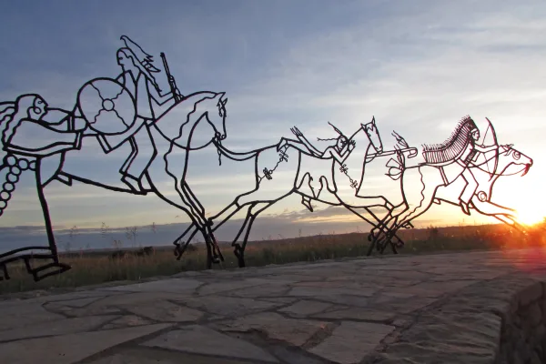
Little Bighorn Battlefield National Monument
National Monument
This land is a place to honor and reflect on the sacrifices made here on June 25 and 26, 1876, when Lakota, Cheyenne, and Arapaho warriors fought against a deliberate attack by the U.S. Army's 7th Cav...
1 mi from route
~3 min detour
$25
near mile 18.1
Park Closure: The Park is ONLY OPEN Friday, Saturday, and Sunday.
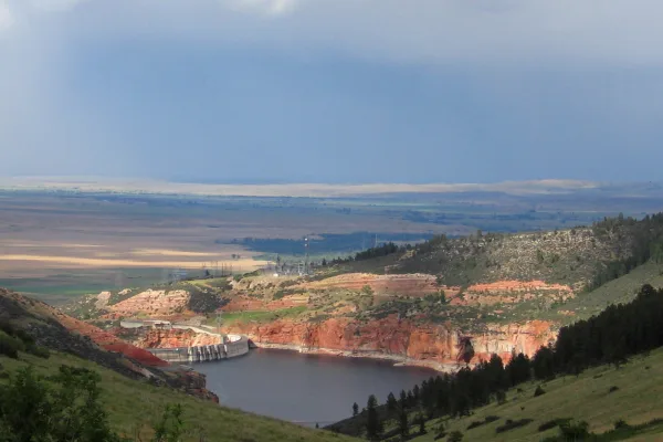
The vast, wild landscape of Bighorn Canyon National Recreation Area offers visitors unparalleled opportunities to immerse themselves in the natural world, and experience the wonders of this extraordin...
16 mi from route
~40 min detour
Free
near mile 65.6
Park data from the National Park Service API. Alerts update every 2 hours.
More Details
What kind of drive is this?
This route is predominantly highway-focused, with 82% of the drive taking place on faster roads. You'll spend a good portion of your time on I 90, interspersed with segments on Secondary State Highway 313 and Crow-Saint Xavier Road. The longest continuous stretch without needing to change roads is 32 miles on Secondary State Highway 313, offering a sustained period of steady driving. The character of the drive shifts between highway speeds and potentially slower local road conditions, so be prepared for varied driving experiences. It's a functional drive designed for getting from point A to point B effectively.
82% highway — fuel and pacing are the main things to plan.
13 navigation steps total — most of the decisions cluster near the start and finish.
Longest single stretch: 32 mi on Secondary State Highway 313.
How Hard Is This Drive?
1/10
This is a straightforward highway drive that stays mostly on Secondary State Highway 313 and I 90. Navigation is very simple - set it and forget it for most of the drive. The trickiest moment comes around 1 miles in.
Driving Effort1/10
Very easy - short and simple to drive
Balances navigation complexity with total wheel time.
The drive from Lodge Grass, MT to Fort Smith, MT is easy. At 1h 40m with 82% highway, most drivers will find it relaxed and low-stress.
Where does it get tricky?
The main spots that need attention: at 1 miles: Navigation decision point; at 22.4 miles: Navigation decision point; at 23.2 miles: Navigation decision point.
The longest stretch is about 32 miles on Secondary State Highway 313. The full list of main roads is in the Roads section above.
Yes. At under 2 hours behind the wheel, this works well for families — plan one quick stop if you have younger kids.
Mostly yes along the main roads, but rural stretches through MT can have sparse or no coverage. Before you leave, download offline Google Maps or Apple Maps for the route, and consider downloading music or podcasts instead of streaming. If you depend on data for navigation, keep a paper backup of the turn-by-turn directions.
The main spots that need attention: at 1 miles: Navigation decision point; at 22.4 miles: Navigation decision point; at 23.2 miles: Navigation decision point.
Yes — Little Bighorn Battlefield National Monument and Bighorn Canyon National Recreation Area. See the National Parks section for detour distances and tips on detours.
Yes. A round trip is manageable in a single day if you plan a break at Fort Smith, MT before heading back.