This 244.6-mile drive from Lame Deer to Bozeman, Montana, is a straightforward, highway-focused journey that can easily be completed in a single day, with an estimated duration of 4 hours and 11 minutes. You'll primarily be on I-90 and US 212, with a 98% highway share, making it a smooth and efficient trip. The estimated fuel cost for this route is around $39, and you'll encounter one recommended stop along the way. Both your origin and destination are within the Mountain West region, so expect consistent, expansive scenery throughout your travels. This route is ideal for a day trip, allowing you to reach your destination without needing an overnight stay.
Trip Pace
Same-day drive is realistic
A same-day return is possible, but it will make for a full day on the road.
Break Rhythm
1 planned break
Plan on a short reset every 3 to 4 hours to stay fresh behind the wheel.
Midpoint
122.3 miles from Lame Deer, MT
A natural place for your longest stop of the day
, about 2h 10m into the drive
.
Main Roads
Road
Distance
Duration
I 90
113.5 mi
1h 48m
US 212
83.8 mi
1h 24m
US Highway 212
41.8 mi
49m
Frontage Road
3.6 mi
4m
East Main Street
1.6 mi
4m
North Willson Avenue
<0.1 mi
<1m
Moffit Gulch Road
<0.1 mi
<1m
Longest stretch:
I 90
— 113.5 mi, about 1h 48m
Traffic on I-90
Hour-of-day weekday pattern from 20 FHWA count stations on your route.
Peak
4 PM
~770 veh/hr typical
· worst 941
Quietest
2 AM
~44 veh/hr
Peak-to-quiet ratio
17.5×
busier at peak than in the quiet hours
12a6anoon6p11p
Averaged across 52 weeks of 2023 FHWA Travel Monitoring Analysis System data. Weekday hours only (Mon–Fri).
Turn-by-Turn Driving Directions
Step-by-step road directions between Lame Deer, MT and Bozeman, MT.
1
Start on this road
384 ft·6 sec·this road
2
Continue on US 212
42 mi·49 min·US Highway 212
3
Take the exit
429 ft·10 sec
4
Continue on US 212
84 mi·1 hr 24 min·US 212
5
Continue on I 90
113 mi·1 hr 48 min·I 90
6
Take the exit
0.2 mi·28 sec
Toward Bear Canyon Road
7
Turn right onto Moffit Gulch Road
77 ft·6 sec·Moffit Gulch Road
8
Turn left onto Frontage Road
3.6 mi·4 min·Frontage Road
9
Continue on East Main Street
1.6 mi·4 min·East Main Street
10
Turn right onto North Willson Avenue
130 ft·3 sec·North Willson Avenue
11
Arrive at destination
North Willson Avenue
Trip Plan
Given the 4-hour and 11-minute duration, starting your journey from Lame Deer in the morning is advisable to maximize daylight and allow for a comfortable pace. With only one recommended stop, you have plenty of flexibility to decide when and where to take breaks, but it's wise to plan for fuel before you depart or at your designated stop, especially considering the longest stretch is over 100 miles. Keep an eye on your fuel gauge, as services can be spread out on these highways. The $39 fuel cost is a good estimate, but actual prices may vary, so budgeting a little extra is always a smart move for any road trip.
Morning Departure
An early start around 7-8 AM gets you there with plenty of daylight left.
Evening Departure
A late afternoon start means arriving after dark. Morning is better.
You can normally do this drive in one day.
Plan roughly 1 meaningful break for fuel, food, and rest.
The halfway point lands around 122.3 miles from Lame Deer, MT, or about 2h 10m into the drive.
The longest continuous stretch on this route runs about 113.5 miles.
This is a comfortable same-day trip.
Departure
Before you leave
Start with fuel, water, and navigation already sorted so the first hour feels easy.
First stop
Around 54 miles or 1h 1m in
Use this first pause for coffee, a restroom break, and a quick traffic check ahead.
Halfway reset
Around 122.3 miles or 2h 10m in
This is the best place for your longest stop, a real meal, and a full fuel check.
Final approach
Final hour starts around 3h 25m
Traffic, exits, and arrival timing usually matter more near Bozeman, MT than in the middle of the route.
Before You Leave
+
Open the route before leaving Lame Deer, MT so your first major turns are already loaded.
+
Leave with enough water and a charging cable within reach, not packed away.
+
Check your fuel range against the first long segment, especially if you are starting outside city service areas.
Day 1
Settle into the route from Lame Deer, MT
This is one driving day of about 244.6 miles and 4h 11m.
Your first comfortable stop window is around 54 miles from Lame Deer, MT.
This route can stay practical as a one-day drive if traffic stays reasonable.
Plan about 1 real break rather than only quick fuel stops.
The longest stretch is on I 90 for about 113.5 miles.
Where to Stop
Rest stops, refuel points, and overnight suggestions along this route.
Place data sourced from public business listings. Hours and availability may vary.
Heads-up: tricky spots
5 of 5
5 decision points cluster between mile 41.8 and 244.6 — GPS handles the exact turns, but know they're coming. Your lane choice matters more than the turn itself.
3
41.8 mi into trip|~49m in
Take the exit
Exit ramp - move to the correct lane early
4
239.2 mi into trip|~4h 2m in
Take the exit toward Bear Canyon Road
Exit ramp - move to the correct lane early
Toward Bear Canyon Road
4
239.5 mi into trip|~4h 3m in|Moffit Gulch Road
Turn right onto Moffit Gulch Road
Navigation decision point
3
239.5 mi into trip|~4h 3m in|Frontage Road
Turn left onto Frontage Road
Navigation decision point
4
244.6 mi into trip|~4h 11m in|North Willson Avenue
Turn right onto North Willson Avenue
Navigation decision point
Fuel & Cost
Regular Gas
$38.12 one way
$76.25 round trip
$3.96/gal25.4 MPG avg86 kg CO2
Fuel Type
$/gal
One Way
Round Trip
midgrade
$4.17
$40.19
$80.37
premium
$4.47
$43.08
$86.17
diesel
$4.80
$46.19
$92.37
No toll roads detected on this route.
Estimated Trip Cost (one way, 1 person)
Fuel
$38
Meals
$25–$50
Total
$63–$88
Rough estimate based on US averages. Hotel $80–$140/night, meals $25–$50/day.
Estimated CO2 emission: 85.6 kg one way.
Prices: EIA weekly data, 2026-07-13.
Driving Electric?
About $26 in charging
· 0 stops
· 66% less CO2
Vehicle Type
kWh
Stops
DC Fast
Home Charge
Average EV
73.4
0
$25.68
$11.74
Efficient EV
61.2
0
$21.40
$9.78
EV Truck/SUV
97.8
1
$34.24
$15.65
Gas CO2
86 kg
EV CO2
29 kg (66% less)
Plan for 0 charging stops, roughly every 270 miles. Allow 25-40 minutes per stop at a DC fast charger.
DC fast charging avg $0.35/kWh. Home charging avg $0.16/kWh. US grid CO2: 0.39 kg/kWh.
Travel Intel
Current conditions at both ends of the drive.
Forecast as of Jul 18, 2026
Origin
Lame Deer, MT
Night
in Lame Deer on Saturday
Local time
9:47 PM
MDT
Current temp
94°F
Mostly Sunny
S 6 to 9 mph11% chanceLive forecast
Destination
Bozeman, MT
Night
in Bozeman on Saturday
Local time
9:47 PM
MDT
Current temp
91°F
Mostly Sunny then Chance Showers And Thunderstorms
NNW 1 to 7 mph27% chanceLive forecast
62°F
Columbus, MT
122 mi in
Seasonal Notes
Summer travel usually means heavier construction, hotter rest stops, and busier weekend traffic around major cities.
Winter travel shortens daylight, so a route that looks manageable on paper can feel much longer after dark.
Holiday weekends tend to make both departure and arrival windows slower than the raw route time suggests.
Time zone
Same local time
Origin and destination are on the same clock, so arrival timing is easier to judge at a glance.
Temperature spread
3 degrees cooler at arrival
A meaningful temperature swing is a good cue to rethink layers, water, and how soon you want to arrive.
Road read
4h 11m on the road
An early start around 7-8 AM gets you there with plenty of daylight left.
Weather data from the National Weather Service. Conditions may change; check closer to your travel date.
National Parks Near This Route
Worth a detour if your schedule allows.
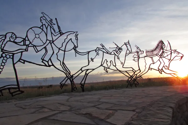
Little Bighorn Battlefield National Monument
National Monument
This land is a place to honor and reflect on the sacrifices made here on June 25 and 26, 1876, when Lakota, Cheyenne, and Arapaho warriors fought against a deliberate attack by the U.S. Army's 7th Cav...
2 mi from route
~6 min detour
$25
near mile 42.2
Park Closure: The Park is ONLY OPEN Friday, Saturday, and Sunday.
Park data from the National Park Service API. Alerts update every 2 hours.
More Details
What kind of drive is this?
Expect a predominantly highway experience on this route, with 98% of the drive utilizing major roads like I-90 and US 212. The character of the drive is largely defined by these high-speed corridors, offering a consistent pace. You'll encounter one significant uninterrupted stretch of 113.5 miles on I-90, which means you can cover a lot of ground between services. While primarily highway, the route is designed for efficient travel rather than slow, scenic meandering, allowing you to focus on reaching your destination.
98% highway — fuel and pacing are the main things to plan.
11 navigation steps total — most of the decisions cluster near the start and finish.
Longest single stretch: 113.5 mi on I 90.
How Hard Is This Drive?
3/10
This is a straightforward highway drive that stays mostly on I 90 and US 212. There are only a few real navigation decisions along the way. The trickiest moment comes around 41.8 miles in.
Driving Effort3/10
Easy - simple navigation with a manageable amount of wheel time
Balances navigation complexity with total wheel time.
This is a straightforward 4h 11m drive. You will face about 5 decision points, but nothing that requires special attention if you follow navigation.
Where does it get tricky?
The main spots that need attention: at 41.8 miles: Exit ramp - move to the correct lane early; at 239.2 miles: Exit ramp - move to the correct lane early; at 239.5 miles (Moffit Gulch Road): Navigation decision point.
Lame Deer is in southeast Montana. It is on the Northern Cheyenne Indian Reservation and serves as the tribal headquarters. About 1,900 people live there.
Bozeman is a city in Montana's Yellowstone Country. Set in the middle of the Rocky Mountains, this college town is a place for experiencing the great outdoors around the year, and for those days the weather makes you want to stay indoors there are a number of museums and galleries to explore.
Top landmarks
•First Presbyterian Church, Bozeman — protestant church in Bozeman, Montana
•American Computer & Robotics Museum — computer museum in Bozeman, Montana
•Bon Ton Historic District — historic district in Montana, United States
The longest stretch is about 113.5 miles on I 90. The full list of main roads is in the Roads section above.
Yes — we found about 11 rest areas or service plazas within a short detour of the route (from OpenStreetMap). See the Rest Stops tab under Nearby Places for locations and mile markers. Plan to stretch, use the bathroom, and top off fluids every 2–3 hours on longer drives.
Yes, with realistic expectations. Build in a stop roughly every 2 hours, have snacks and activities ready, and check the Nearby Places tabs for kid-friendly stops along the way.
Mostly yes along the main roads, but rural stretches through MT can have sparse or no coverage. Before you leave, download offline Google Maps or Apple Maps for the route, and consider downloading music or podcasts instead of streaming. If you depend on data for navigation, keep a paper backup of the turn-by-turn directions.
The main spots that need attention: at 41.8 miles: Exit ramp - move to the correct lane early; at 239.2 miles: Exit ramp - move to the correct lane early; at 239.5 miles (Moffit Gulch Road): Navigation decision point.
Yes — Little Bighorn Battlefield National Monument. See the National Parks section for detour distances and tips on detours.
Possible but tiring. At 4.2 hours each way, an in-and-out day trip would put you behind the wheel for 8.4 hours — manageable with a long break at Bozeman, MT, but most travelers stay overnight.