This 171-mile drive from Klamath Falls to Springfield, Oregon, is easily manageable as a single-day trip, estimated to take just over 3 hours. You'll navigate primarily on local roads like Klamath Avenue, South 12th Street, and Main Street, with no significant highway driving. The estimated fuel cost for this journey is around $34. Given its relatively short duration and local road focus, this route offers a relaxed pace, making it ideal for a straightforward transition between the Pacific Coast regions of Oregon. It's a practical option if you're looking for a direct and uncomplicated way to cover this distance.
Trip Pace
Same-day drive is realistic
A same-day return is realistic if you keep stops short.
Break Rhythm
1 planned break
A short stop every 2 to 3 hours is enough for this drive.
Midpoint
85 miles from Klamath Falls, OR
A natural place for your longest stop of the day
, about 1h 43m into the drive
.
Main Roads
Road
Distance
Duration
The Dalles-California Highway
77.3 mi
1h 31m
State Highway 58
38.1 mi
52m
OR 58
23.8 mi
32m
Williamette Highway
12 mi
16m
Highway 58
8.6 mi
14m
Franklin Boulevard
2.2 mi
4m
Willamette Highway
2 mi
2m
Crater Lake Parkway
1.8 mi
2m
Longest stretch:
The Dalles-California Highway
— 77.3 mi, about 1h 31m
Turn-by-Turn Driving Directions
Step-by-step road directions between Klamath Falls, OR and Springfield, OR.
1
Start on South 7th Street
141 ft·13 sec·South 7th Street
2
Turn left onto US 97 Business
0.3 mi·32 sec·Klamath Avenue
3
Turn left onto US 97 Business
298 ft·10 sec·South 12th Street
4
Turn right onto US 97 Business
131 ft·2 sec·Main Street
5
Turn straight onto US 97 Business
0.3 mi·33 sec·Esplanade Avenue
6
Turn left onto US 97 Business; OR 39
1.8 mi·2 min·Crater Lake Parkway
7
Continue on US 97
77 mi·1 hr 31 min·The Dalles-California Highway
8
Take the exit onto OR 58
4.5 mi·6 min·State Highway 58
Toward OR 58 West: Oakridge, Eugene
9
Continue on OR 58
12 mi·16 min·Williamette Highway
10
Continue on OR 58
33 mi·44 min·State Highway 58
11
Continue on OR 58
3.0 mi·5 min·Highway 58
12
Continue on OR 58
0.7 mi·57 sec·State Highway 58
13
Turn right onto Westfir-Oakridge Road
1.3 mi·1 min·Westfir-Oakridge Road
14
Turn left onto Westfir Road
0.5 mi·49 sec·Westfir Road
15
Turn right onto OR 58
23 mi·31 min·OR 58
16
Continue on OR 58
5.6 mi·9 min·Highway 58
17
Continue on OR 58
2.0 mi·2 min·Willamette Highway
18
Keep slight right at fork onto OR 58
0.5 mi·59 sec·OR 58
Toward I 5 North, OR 99: Eugene
19
Merge onto I 5; OR 99
1.0 mi·1 min·I 5; OR 99
20
Take the exit onto OR 225
0.3 mi·27 sec·McVey Highway #225 Roadway #2
Toward OR 225: South Eugene
21
Continue on Franklin Boulevard
2.2 mi·4 min·Franklin Boulevard
22
Enter roundabout onto OR 126 Business
23 ft·0 sec·South A Street
23
Continue on OR 126 Business
0.4 mi·1 min·South A Street
24
Turn left onto OR 528
202 ft·5 sec·Pioneer Parkway East
25
Arrive at destination
OR 528
Trip Plan
For this 171-mile, 3-hour drive, departing anytime from mid-morning will allow you to avoid early rush hour in Klamath Falls and still arrive in Springfield with plenty of daylight. Since the route is primarily local roads and has only one recommended stop, you can easily complete it without needing to split it. Keep an eye on your fuel gauge, as the $34 estimated cost is based on current conditions, and local roads can sometimes lead to slightly higher consumption than steady highway speeds. A good tip for this specific route is to familiarize yourself with the main road names – Klamath Avenue, South 12th Street, and Main Street – before you depart, as they will be your primary navigational points.
Morning Departure
An early start around 7-8 AM gets you there with plenty of daylight left.
Evening Departure
A late afternoon start means arriving after dark. Morning is better.
You can normally do this drive in one day.
Plan roughly 1 meaningful break for fuel, food, and rest.
The halfway point lands around 85 miles from Klamath Falls, OR, or about 1h 43m into the drive.
The longest continuous stretch on this route runs about 77.3 miles.
This is a comfortable same-day trip.
Departure
Before you leave
Start with fuel, water, and navigation already sorted so the first hour feels easy.
First stop
Around 37 miles or 45m in
Use this first pause for coffee, a restroom break, and a quick traffic check ahead.
Halfway reset
Around 85 miles or 1h 43m in
This is the best place for your longest stop, a real meal, and a full fuel check.
Final approach
Final hour starts around 2h 59m
Traffic, exits, and arrival timing usually matter more near Springfield, OR than in the middle of the route.
Before You Leave
+
Open the route before leaving Klamath Falls, OR so your first major turns are already loaded.
+
Leave with enough water and a charging cable within reach, not packed away.
+
Check your fuel range against the first long segment, especially if you are starting outside city service areas.
Day 1
Settle into the route from Klamath Falls, OR
This is one driving day of about 170 miles and 3h 44m.
Your first comfortable stop window is around 37 miles from Klamath Falls, OR.
This route can stay practical as a one-day drive if traffic stays reasonable.
Plan about 1 real break rather than only quick fuel stops.
The longest stretch is on The Dalles-California Highway for about 77.3 miles.
Where to Stop
Rest stops, refuel points, and overnight suggestions along this route.
Place data sourced from public business listings. Hours and availability may vary.
Heads-up: tricky spots
5 of 12
5 decision points cluster between mile 0 and 165.7 — GPS handles the exact turns, but know they're coming. Your lane choice matters more than the turn itself.
5
0 mi into trip|~0m in|US 97 Business / Klamath Avenue
Turn left onto US 97 Business / Klamath Avenue
Navigation decision point
5
0.3 mi into trip|~0m in|US 97 Business / South 12th Street
Turn left onto US 97 Business / South 12th Street
Navigation decision point
5
0.3 mi into trip|~0m in|US 97 Business / Main Street
Turn right onto US 97 Business / Main Street
Navigation decision point
5
79.9 mi into trip|~1h 35m in|OR 58 / State Highway 58
Take the exit onto OR 58 / State Highway 58 toward OR 58 West: Oakridge, Eugene
Exit ramp - move to the correct lane early. Multiple destination signs - pick the right one
Toward OR 58 West: Oakridge, Eugene
6
165.7 mi into trip|~3h 36m in|OR 58
Keep slight right at fork onto OR 58 toward I 5 North, OR 99: Eugene
Highway fork - watch signs carefully. Multiple destination signs - pick the right one
Toward I 5 North, OR 99: Eugene
Fuel & Cost
Regular Gas
$33.87 one way
$67.73 round trip
$5.06/gal25.4 MPG avg60 kg CO2
Fuel Type
$/gal
One Way
Round Trip
midgrade
$5.36
$35.84
$71.68
premium
$5.59
$37.42
$74.84
diesel
$5.61
$37.53
$75.07
No toll roads detected on this route.
Estimated Trip Cost (one way, 1 person)
Fuel
$34
Meals
$25–$50
Total
$59–$84
Rough estimate based on US averages. Hotel $80–$140/night, meals $25–$50/day.
Estimated CO2 emission: 59.5 kg one way.
Prices: EIA weekly data, 2026-04-13.
Driving Electric?
About $18 in charging
· 0 stops
· 66% less CO2
Vehicle Type
kWh
Stops
DC Fast
Home Charge
Average EV
51
0
$17.85
$8.16
Efficient EV
42.5
0
$14.87
$6.80
EV Truck/SUV
68
0
$23.80
$10.88
Gas CO2
59 kg
EV CO2
20 kg (66% less)
This trip is well within single-charge range for most EVs. No charging stops needed if you start fully charged.
DC fast charging avg $0.35/kWh. Home charging avg $0.16/kWh. US grid CO2: 0.39 kg/kWh.
Travel Intel
Current conditions at both ends of the drive.
Forecast as of Apr 16, 2026
Origin
Klamath Falls, OR
Late night
in Klamath Falls on Tuesday
Local time
1:07 AM
PDT
Current temp
47°F
Sunny
NW 15 mph1% chanceLive forecast
Freeze Warning
Freeze Warning issued April 16 at 2:04PM MDT until April 17 at 10:00AM MDT by NWS Boise ID
Freeze Warning
Freeze Warning issued April 16 at 10:45AM PDT until April 17 at 9:00AM PDT by NWS Portland OR
Destination
Springfield, OR
Late night
in Springfield on Tuesday
Local time
1:07 AM
PDT
Current temp
55°F
Sunny
WNW 3 mph3% chanceLive forecast
Freeze Warning
Freeze Warning issued April 16 at 2:04PM MDT until April 17 at 10:00AM MDT by NWS Boise ID
Freeze Warning
Freeze Warning issued April 16 at 10:45AM PDT until April 17 at 9:00AM PDT by NWS Portland OR
Seasonal Notes
Summer travel usually means heavier construction, hotter rest stops, and busier weekend traffic around major cities.
Winter travel shortens daylight, so a route that looks manageable on paper can feel much longer after dark.
Holiday weekends tend to make both departure and arrival windows slower than the raw route time suggests.
Time zone
Same local time
Origin and destination are on the same clock, so arrival timing is easier to judge at a glance.
Temperature spread
8 degrees warmer at arrival
A meaningful temperature swing is a good cue to rethink layers, water, and how soon you want to arrive.
Road read
3h 44m on the road
The weather snapshot is not static. If you are leaving later, give both cities one more quick forecast check before departure.
Weather data from the National Weather Service. Conditions may change; check closer to your travel date.
National Parks Near This Route
Worth a detour if your schedule allows.
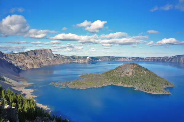
Crater Lake National Park
National Park
Crater Lake inspires awe. Native Americans witnessed its formation 7,700 years ago, when a violent eruption triggered the collapse of a tall peak. Scientists marvel at its purity—fed by rain and snow,...
16 mi from route
~39 min detour
$30
near mile 52.8
Park Closure: Road to Rim Village is Temporarily CLOSED Due to Incoming Snowstorm
Park Closure: Cleetwood Cove Trail is CLOSED for Rehabilitation
Park data from the National Park Service API. Alerts update every 2 hours.
More Details
What kind of drive is this?
Expect a turn-heavy local drive for the entirety of this 171-mile journey from Klamath Falls to Springfield. With a 0% highway share, you'll be navigating through towns and connecting local streets for the full 3 hours and 6 minutes. There isn't a 'longest stretch' to note, as the nature of this drive suggests frequent intersections and changes in road names. This means you'll be actively engaged with the road, managing local traffic and potentially varying speed limits as you move through different communities.
43% highway, the rest on surface roads — varied driving throughout.
25 navigation steps total — most of the decisions cluster near the start and finish.
Longest single stretch: 77.3 mi on The Dalles-California Highway.
How Hard Is This Drive?
3/10
This route mixes highway mileage with some local-road sections near the start or finish. There are only a few real navigation decisions along the way. The trickiest moment comes early in the drive near US 97 Business / Klamath Avenue.
Driving Effort3/10
Easy - simple navigation with a manageable amount of wheel time
Balances navigation complexity with total wheel time.
This is a straightforward 3h 44m drive. You will face about 12 decision points, but nothing that requires special attention if you follow navigation.
Where does it get tricky?
The main spots that need attention: near the start (US 97 Business / Klamath Avenue): Navigation decision point; at 0.3 miles (US 97 Business / South 12th Street): Navigation decision point; at 0.3 miles (US 97 Business / Main Street): Navigation decision point.
Towns Mentioned on Route Signs
Based on OSRM destination-sign hints, not a full list of every settlement the road passes.
On the drive from Klamath Falls, OR to Springfield, OR, road signs begin pointing toward Eugene along the way.
Klamath Falls (sometimes called Klamath by locals) is a small Southern Oregon city found in the eastern foothills of the Cascade Range. Klamath Falls is at the southern end of Klamath Lake in the large Klamath Basin. Klamath enjoys quite spectacular views. Snow-covered Mount Shasta, one of the most prominent peaks in the United States, can be seen on the southern horizon, and the outlying areas are filled with acres of farmland. Popular with outdoor enthusiasts, birdwatchers, history buffs, and fans of rural America, Klamath is a place many people are glad they didn't miss.
Mixed highway & surface route profile with national parks nearby.
Frequently Asked Questions
The longest stretch is about 77.3 miles on The Dalles-California Highway. The full list of main roads is in the Roads section above.
Yes — we found about 7 rest areas or service plazas within a short detour of the route (from OpenStreetMap). See the Rest Stops tab under Nearby Places for locations and mile markers. Plan to stretch, use the bathroom, and top off fluids every 2–3 hours on longer drives.
Yes, with realistic expectations. Build in a stop roughly every 2 hours, have snacks and activities ready, and check the Nearby Places tabs for kid-friendly stops along the way.
The main spots that need attention: near the start (US 97 Business / Klamath Avenue): Navigation decision point; at 0.3 miles (US 97 Business / South 12th Street): Navigation decision point; at 0.3 miles (US 97 Business / Main Street): Navigation decision point.
Yes — Crater Lake National Park. See the National Parks section for detour distances and tips on detours.
Possible but tiring. At 3.7 hours each way, an in-and-out day trip would put you behind the wheel for 7.5 hours — manageable with a long break at Springfield, OR, but most travelers stay overnight.