Klamath Falls, OR to Aloha, OR is 278.9 miles and takes about 5h 55m via I 5 and State Highway 58, with a fuel budget near $58 and enough daylight to finish in a day. This trip stays within Oregon, moving from the Pacific Coast region towards the same region. The profile is mostly highway, making it a straightforward drive. It's a good option if you're looking for a single-day trip that doesn't require overnight stops. Plan for a total driving time of under six hours, plus any time you might spend on breaks.
Trip Pace
Same-day drive is realistic
A same-day return is possible, but it will make for a full day on the road.
Break Rhythm
1 planned break
Plan on a short reset every 3 to 4 hours to stay fresh behind the wheel.
Midpoint
139.5 miles from Klamath Falls, OR
A natural place for your longest stop of the day
, about 2h 59m into the drive
.
Main Roads
Road
Distance
Duration
I 5
103.3 mi
2h 1m
The Dalles-California Highway
77.3 mi
1h 31m
State Highway 58
38.1 mi
52m
OR 58
23.8 mi
32m
Williamette Highway
12 mi
16m
Highway 58
8.6 mi
14m
Beaverton-Tigard Freeway
4.8 mi
6m
Southwest Tualatin Valley Highway
2.6 mi
5m
Longest stretch:
I 5
— 103.3 mi, about 2h 1m
Traffic on I-5
Hour-of-day weekday pattern from 25 FHWA count stations on your route.
Peak
4 PM
~3,444 veh/hr typical
Quietest
1 AM
~265 veh/hr
Peak-to-quiet ratio
13×
busier at peak than in the quiet hours
12a6anoon6p11p
Averaged across 52 weeks of 2023 FHWA Travel Monitoring Analysis System data. Weekday hours only (Mon–Fri).
Turn-by-Turn Driving Directions
Step-by-step road directions between Klamath Falls, OR and Aloha, OR.
1
Start on South 7th Street
141 ft·13 sec·South 7th Street
2
Turn left onto US 97 Business
0.3 mi·32 sec·Klamath Avenue
3
Turn left onto US 97 Business
298 ft·10 sec·South 12th Street
4
Turn right onto US 97 Business
131 ft·2 sec·Main Street
5
Turn straight onto US 97 Business
0.3 mi·33 sec·Esplanade Avenue
6
Turn left onto US 97 Business; OR 39
1.8 mi·2 min·Crater Lake Parkway
7
Continue on US 97
77 mi·1 hr 31 min·The Dalles-California Highway
8
Take the exit onto OR 58
4.5 mi·6 min·State Highway 58
Toward OR 58 West: Oakridge, Eugene
9
Continue on OR 58
12 mi·16 min·Williamette Highway
10
Continue on OR 58
33 mi·44 min·State Highway 58
11
Continue on OR 58
3.0 mi·5 min·Highway 58
12
Continue on OR 58
0.7 mi·57 sec·State Highway 58
13
Turn right onto Westfir-Oakridge Road
1.3 mi·1 min·Westfir-Oakridge Road
14
Turn left onto Westfir Road
0.5 mi·49 sec·Westfir Road
15
Turn right onto OR 58
23 mi·31 min·OR 58
16
Continue on OR 58
5.6 mi·9 min·Highway 58
17
Continue on OR 58
2.0 mi·2 min·Willamette Highway
18
Keep slight right at fork onto OR 58
0.5 mi·59 sec·OR 58
Toward I 5 North, OR 99: Eugene
19
Merge onto I 5; OR 99
103 mi·2 hr 1 min·I 5; OR 99
Use the straight lane.
20
Take the exit
0.8 mi·1 min
Exit 292AToward OR 217: Tigard, BeavertonUse the straight / slight right lanes.
21
Merge onto OR 217
4.8 mi·6 min·Beaverton-Tigard Freeway
22
Take the exit
0.2 mi·33 sec
Exit 2AToward OR 8, OR 10: Beaverton, Canyon RoadUse the straight / slight right lanes.
For this 5h 55m drive, leaving Klamath Falls in the morning should give you plenty of daylight to reach Aloha. Since it's a single-day trip with a manageable distance, you can afford to be flexible with stops. The route is mostly highway, so keep an eye on your fuel gauge, especially before the longest stretch of 103.3 miles on I 5. Consider topping off your tank in Klamath Falls or a larger town along I 5 before heading into more rural sections. The $58 fuel cost estimate is helpful for budgeting.
Morning Departure
An early start around 7-8 AM gets you there with plenty of daylight left.
Evening Departure
A late afternoon start means arriving after dark. Morning is better.
You can normally do this drive in one day.
Plan roughly 1 meaningful break for fuel, food, and rest.
The halfway point lands around 139.5 miles from Klamath Falls, OR, or about 2h 59m into the drive.
The longest continuous stretch on this route runs about 103.3 miles.
This is a comfortable same-day trip.
Departure
Before you leave
Start with fuel, water, and navigation already sorted so the first hour feels easy.
First stop
Around 61 miles or 1h 13m in
Use this first pause for coffee, a restroom break, and a quick traffic check ahead.
Halfway reset
Around 139.5 miles or 2h 59m in
This is the best place for your longest stop, a real meal, and a full fuel check.
Final approach
Final hour starts around 4h 51m
Traffic, exits, and arrival timing usually matter more near Aloha, OR than in the middle of the route.
Before You Leave
+
Open the route before leaving Klamath Falls, OR so your first major turns are already loaded.
+
Leave with enough water and a charging cable within reach, not packed away.
+
Check your fuel range against the first long segment, especially if you are starting outside city service areas.
Day 1
Settle into the route from Klamath Falls, OR
This is one driving day of about 278.9 miles and 5h 55m.
Your first comfortable stop window is around 61 miles from Klamath Falls, OR.
This route can stay practical as a one-day drive if traffic stays reasonable.
Plan about 1 real break rather than only quick fuel stops.
The longest stretch is on I 5 for about 103.3 miles.
Where to Stop
Rest stops, refuel points, and overnight suggestions along this route.
Place data sourced from public business listings. Hours and availability may vary.
Heads-up: tricky spots
5 of 17
5 decision points cluster between mile 0 and 275.1 — GPS handles the exact turns, but know they're coming. Your lane choice matters more than the turn itself.
5
0 mi into trip|~0m in|US 97 Business / Klamath Avenue
Turn left onto US 97 Business / Klamath Avenue
Navigation decision point
6
165.7 mi into trip|~3h 36m in|OR 58
Keep slight right at fork onto OR 58 toward I 5 North, OR 99: Eugene
Highway fork - watch signs carefully. Multiple destination signs - pick the right one
Toward I 5 North, OR 99: Eugene
8
269.4 mi into trip|~5h 38m in
Take the exit toward OR 217: Tigard, Beaverton
Exit ramp - move to the correct lane early. Lane positioning matters here. Multiple destination signs - pick the right one
Use the straight / slight right lanes.
Exit 292A
Toward OR 217: Tigard, Beaverton
8
274.9 mi into trip|~5h 46m in
Take the exit toward OR 8, OR 10: Beaverton, Canyon Road
Exit ramp - move to the correct lane early. Lane positioning matters here. Multiple destination signs - pick the right one
Use the straight / slight right lanes.
Exit 2A
Toward OR 8, OR 10: Beaverton, Canyon Road
6
275.1 mi into trip|~5h 46m in|OR 10 / Southwest Beaverton Hillsdale Highway
Turn left onto OR 10 / Southwest Beaverton Hillsdale Highway
Lane positioning matters here
Use the left / straight lanes.
Fuel & Cost
Regular Gas
$49.42 one way
$98.84 round trip
$4.50/gal25.4 MPG avg98 kg CO2
Fuel Type
$/gal
One Way
Round Trip
midgrade
$4.82
$52.93
$105.85
premium
$5.04
$55.36
$110.73
diesel
$4.80
$52.66
$105.32
No toll roads detected on this route.
Estimated Trip Cost (one way, 1 person)
Fuel
$49
Meals
$25–$50
Total
$74–$99
Rough estimate based on US averages. Hotel $80–$140/night, meals $25–$50/day.
Estimated CO2 emission: 97.6 kg one way.
Prices: EIA weekly data, 2026-07-13.
Driving Electric?
About $29 in charging
· 1 stop
· 66% less CO2
Vehicle Type
kWh
Stops
DC Fast
Home Charge
Average EV
83.7
1
$29.28
$13.39
Efficient EV
69.7
0
$24.40
$11.16
EV Truck/SUV
111.6
1
$39.05
$17.85
Gas CO2
98 kg
EV CO2
33 kg (66% less)
Plan for 1 charging stop. A 30-minute DC fast charge mid-route should be enough to complete the trip comfortably.
DC fast charging avg $0.35/kWh. Home charging avg $0.16/kWh. US grid CO2: 0.39 kg/kWh.
Travel Intel
Current conditions at both ends of the drive.
Forecast as of Jul 18, 2026
Origin
Klamath Falls, OR
Morning
in Klamath Falls on Sunday
Local time
9:41 AM
PDT
Current temp
52°F
Smoke
NNW 0 to 16 mph0% chanceLive forecast
Red Flag Warning
Red Flag Warning issued July 17 at 2:01PM PDT until July 17 at 8:00PM PDT by NWS Medford OR
Red Flag Warning
Red Flag Warning issued July 17 at 10:23AM PDT until July 18 at 10:00PM PDT by NWS Pendleton OR
Destination
Aloha, OR
Morning
in Aloha on Sunday
Local time
9:41 AM
PDT
Current temp
54°F
Mostly Clear
NNW 1 to 5 mph0% chanceLive forecast
Red Flag Warning
Red Flag Warning issued July 17 at 2:01PM PDT until July 17 at 8:00PM PDT by NWS Medford OR
Red Flag Warning
Red Flag Warning issued July 17 at 10:23AM PDT until July 18 at 10:00PM PDT by NWS Pendleton OR
Seasonal Notes
Summer travel usually means heavier construction, hotter rest stops, and busier weekend traffic around major cities.
Winter travel shortens daylight, so a route that looks manageable on paper can feel much longer after dark.
Holiday weekends tend to make both departure and arrival windows slower than the raw route time suggests.
Time zone
Same local time
Origin and destination are on the same clock, so arrival timing is easier to judge at a glance.
Temperature spread
2 degrees warmer at arrival
A meaningful temperature swing is a good cue to rethink layers, water, and how soon you want to arrive.
Road read
5h 55m on the road
An early start around 7-8 AM gets you there with plenty of daylight left.
Weather data from the National Weather Service. Conditions may change; check closer to your travel date.
National Parks Near This Route
Worth a detour if your schedule allows.
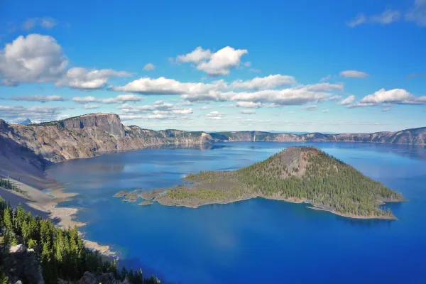
Crater Lake National Park
National Park
Crater Lake inspires awe. Native Americans witnessed its formation 7,700 years ago, when a violent eruption triggered the collapse of a tall peak. Scientists marvel at its purity—fed by rain and snow,...
16 mi from route
~40 min detour
$30
near mile 48.1
Park Closure: Cleetwood Cove Trail is CLOSED for Rehabilitation
Park Closure: North Entrance Road and Rim Drive are CLOSED for the Season
Park data from the National Park Service API. Alerts update every 2 hours.
More Details
What kind of drive is this?
You'll spend about 65% of this 278.9-mile drive on highways, primarily I 5. The longest continuous stretch on a highway is 103.3 miles on I 5. After the highway portions, you'll transition to surface roads. Expect a mix of higher-speed cruising and potentially more local traffic as you get closer to your destination, especially on State Highway 58.
65% highway — fuel and pacing are the main things to plan.
30 navigation steps total — most of the decisions cluster near the start and finish.
Longest single stretch: 103.3 mi on I 5.
How Hard Is This Drive?
7/10
This is a straightforward highway drive that stays mostly on I 5 and The Dalles-California Highway. This route has several spots where lane changes, forks, or exits need your full attention. The trickiest moment comes early in the drive near US 97 Business / Klamath Avenue.
Driving Effort7/10
Demanding - plan breaks and stay ahead of the key maneuvers
Balances navigation complexity with total wheel time.
This is a demanding drive. With 17 significant decision points across 278.9 miles, you will need to stay alert - especially through interchange areas and urban stretches. Consider splitting it into segments if you are not comfortable with fast highway navigation.
Where does it get tricky?
The main spots that need attention: near the start (US 97 Business / Klamath Avenue): Navigation decision point; at 165.7 miles (OR 58): Highway fork - watch signs carefully. Multiple destination signs - pick the right one; at 269.4 miles: Exit ramp - move to the correct lane early. Lane positioning matters here. Multiple destination signs - pick the right one.
Elevation Profile
Hilly terrain with moderate elevation changes
4,837 ft186 ft
Total Climb
759 ft
Total Descent
4,651 ft
Highest Point
4,837 ft
~99.6 mi in
Elevation Range
4,651 ft
Notable High Points
4,837 ft at ~99.6 miles+170 ft prominence
Towns Mentioned on Route Signs
Based on OSRM destination-sign hints, not a full list of every settlement the road passes.
On the drive from Klamath Falls, OR to Aloha, OR, road signs begin pointing toward Eugene along the way.
Klamath Falls (sometimes called Klamath by locals) is a small Southern Oregon city found in the eastern foothills of the Cascade Range. Klamath Falls is at the southern end of Klamath Lake in the large Klamath Basin. Klamath enjoys quite spectacular views. Snow-covered Mount Shasta, one of the most prominent peaks in the United States, can be seen on the southern horizon, and the outlying areas are filled with acres of farmland. Popular with outdoor enthusiasts, birdwatchers, history buffs, and fans of rural America, Klamath is a place many people are glad they didn't miss.
Top landmarks
•Baldwin Hotel — historic hotel building in Klamath Falls, Oregon, USA
Aloha is a community of 54,000 people (2020) in Oregon, under 10 miles (16 km) to the west of Portland (Oregon). It is home to the prestigious The Reserve Vineyards and Golf Club, and to the unnervingly creepy Harvey the Rabbit.
Doable as a same-day drive at 5h 55m. Total distance: 278.9 miles.
Family Friendly
Moderate complexity with 1 natural rest stops along the way.
Solo Traveler
5h 55m drive, comfortable solo distance.
Frequently Asked Questions
The longest stretch is about 103.3 miles on I 5. The full list of main roads is in the Roads section above.
Yes — we found about 19 rest areas or service plazas within a short detour of the route (from OpenStreetMap). See the Rest Stops tab under Nearby Places for locations and mile markers. Plan to stretch, use the bathroom, and top off fluids every 2–3 hours on longer drives.
It helps. This route has a higher-than-average number of complex decision points, which get harder in the dark. If the last hour of the trip is on surface roads or mountain grades, aim to arrive at Aloha, OR before sunset when you can. Check the Trip Plan for departure windows that land you in daylight.
Only with planning. This is a long drive for kids — consider splitting it into two days rather than pushing through. Plan at least 1 meaningful breaks. There are 19 rest areas along the route for bathroom stops.
The main spots that need attention: near the start (US 97 Business / Klamath Avenue): Navigation decision point; at 165.7 miles (OR 58): Highway fork - watch signs carefully. Multiple destination signs - pick the right one; at 269.4 miles: Exit ramp - move to the correct lane early. Lane positioning matters here. Multiple destination signs - pick the right one.
Yes — Crater Lake National Park. See the National Parks section for detour distances and tips on detours.
Not recommended in a single day. At 5.9 hours each way, a round trip means 11.8 hours of driving — that is an unsafe level of fatigue for most drivers. Plan at least one night at Aloha, OR before the return drive.