Traveling from Jacksonville to Tavares covers 129.9 miles and typically takes about 2 hours and 53 minutes. Given the manageable duration, this trip is perfectly suited as a simple one-day excursion, meaning you won't need to worry about overnight logistics. You should budget approximately $22 for fuel to complete the journey. The route transitions from the coastal environment of Jacksonville into the inland landscape of Tavares, keeping you within the state of Florida the entire time. Because it is a straightforward highway-focused drive, it serves as a reliable connection between these two regions. Whether you are heading out for business or a quick visit, this trip offers a direct path that keeps travel time efficient.
Trip Pace
Same-day drive is realistic
A same-day return is realistic if you keep stops short.
Break Rhythm
1 planned break
A short stop every 2 to 3 hours is enough for this drive.
Midpoint
65 miles from Jacksonville, FL
A natural place for your longest stop of the day
, about 1h 17m into the drive
.
Main Roads
Road
Distance
Duration
I 95
50.5 mi
55m
FL 19
19.9 mi
30m
East State Road 40
16.2 mi
22m
US 1
15.2 mi
20m
West Moody Boulevard
9.5 mi
12m
FL 11
8.7 mi
10m
CR 445A
4.1 mi
7m
US Highway 441
1.3 mi
2m
Longest stretch:
I 95
— 50.5 mi, about 55m
Turn-by-Turn Driving Directions
Step-by-step road directions between Jacksonville, FL and Tavares, FL.
1
Start on US 17
0.1 mi·20 sec·Union Street
2
Turn right onto Newnan Street
0.4 mi·1 min·Newnan Street
3
Turn right onto FL 228
0.1 mi·23 sec·East Forsyth Street
4
Turn left onto US 1; US 90
0.5 mi·1 min·Main Street
5
Take the ramp onto US 1; US 90
0.9 mi·2 min·US 1; US 90
Toward I 95 South
6
Keep slight right at fork onto US 1
0.2 mi·28 sec·US 1
Toward I 95, US 1 South, FL 5 South: Daytona Beach, Philips Highway
7
Keep slight left at fork
0.2 mi·26 sec
Toward I 95 South: Daytona BeachUse the straight lane.
8
Merge onto I 95
50 mi·55 min·I 95
Use the straight / slight right lanes.
9
Take the exit
0.3 mi·44 sec
Exit 298Toward US 1: Bunnell
10
Keep slight right at fork
188 ft·4 sec
Toward US 1 South: Bunnell
11
Turn straight onto US 1
4.0 mi·4 min·US 1
12
Enter roundabout onto US 1
116 ft·1 sec·US 1
13
Continue on US 1
9.9 mi·13 min·US 1
14
Turn right onto FL 11
9.5 mi·12 min·West Moody Boulevard
15
Enter roundabout onto FL 11
89 ft·1 sec·FL 11
16
Continue on FL 11
8.7 mi·10 min·FL 11
17
Turn right onto FL 40
16 mi·22 min·East State Road 40
18
Turn left onto CR 445A
4.1 mi·7 min·CR 445A
Use the left lane.
19
At end of road, turn left onto FL 19
20 mi·30 min·FL 19
20
Turn right onto West Lakeview Avenue
0.4 mi·54 sec·West Lakeview Avenue
21
Continue on Kurt Street
0.3 mi·34 sec·Kurt Street
22
Turn right onto David Walker Drive
0.7 mi·1 min·David Walker Drive
23
Turn right onto Mount Homer Road
0.7 mi·1 min·Mount Homer Road
24
Turn right onto US 441; FL 19
1.3 mi·2 min·US Highway 441
25
Turn left onto North Saint Clair Abrams Avenue
0.8 mi·2 min·North Saint Clair Abrams Avenue
26
Turn left onto CR Old 441
56 ft·1 sec·East Alfred Street
27
Arrive at destination
CR Old 441
Trip Plan
To make the most of your 2-hour and 53-minute journey, plan for at least one dedicated stop to stretch your legs and refresh. Leaving Jacksonville during off-peak hours is your best strategy for avoiding traffic congestion on the initial I-95 leg. Since you are only anticipating one stop, try to time it for when you transition from the highway segments onto the state roads to maximize your momentum. Keep an eye on your fuel gauge during the 50.5-mile stretch on I-95, as service options can be spaced out. Because this is a relatively short trip, you have plenty of flexibility in your schedule, allowing you to depart whenever it best suits your personal itinerary.
Morning Departure
Leave by 9 AM and you'll arrive before lunch.
Evening Departure
Even a 4 PM departure gets you there before dark in summer.
You can normally do this drive in one day.
Plan roughly 1 meaningful break for fuel, food, and rest.
The halfway point lands around 65 miles from Jacksonville, FL, or about 1h 17m into the drive.
The longest continuous stretch on this route runs about 50.5 miles.
This is a comfortable same-day trip.
Departure
Before you leave
Start with fuel, water, and navigation already sorted so the first hour feels easy.
First stop
Around 29 miles or 35m in
Use this first pause for coffee, a restroom break, and a quick traffic check ahead.
Halfway reset
Around 65 miles or 1h 17m in
This is the best place for your longest stop, a real meal, and a full fuel check.
Final approach
Final hour starts around 2h 14m
Traffic, exits, and arrival timing usually matter more near Tavares, FL than in the middle of the route.
Before You Leave
+
Open the route before leaving Jacksonville, FL so your first major turns are already loaded.
+
Leave with enough water and a charging cable within reach, not packed away.
+
Check your fuel range against the first long segment, especially if you are starting outside city service areas.
Day 1
Settle into the route from Jacksonville, FL
This is one driving day of about 129.9 miles and 2h 53m.
Your first comfortable stop window is around 29 miles from Jacksonville, FL.
This route can stay practical as a one-day drive if traffic stays reasonable.
Plan about 1 real break rather than only quick fuel stops.
The longest stretch is on I 95 for about 50.5 miles.
Where to Stop
Rest stops, refuel points, and overnight suggestions along this route.
Place data sourced from public business listings. Hours and availability may vary.
Heads-up: tricky spots
5 of 19
5 decision points cluster between mile 2 and 53.3 — GPS handles the exact turns, but know they're coming. Your lane choice matters more than the turn itself.
6
2 mi into trip|~5m in|US 1
Keep slight right at fork onto US 1 toward I 95, US 1 South, FL 5 South: Daytona Beach, Philips Highway
Highway fork - watch signs carefully. Multiple destination signs - pick the right one
Toward I 95, US 1 South, FL 5 South: Daytona Be...
8
2.3 mi into trip|~5m in
Keep slight left at fork toward I 95 South: Daytona Beach
Highway fork - watch signs carefully. Lane positioning matters here
Use the straight lane.
Toward I 95 South: Daytona Beach
5
2.5 mi into trip|~6m in|I 95
Merge onto I 95
Merge point - match speed before joining. Lane positioning matters here
Use the straight / slight right lanes.
5
52.9 mi into trip|~1h 1m in
Take the exit toward US 1: Bunnell
Exit ramp - move to the correct lane early
Exit 298
Toward US 1: Bunnell
5
53.3 mi into trip|~1h 2m in
Keep slight right at fork toward US 1 South: Bunnell
Highway fork - watch signs carefully
Toward US 1 South: Bunnell
Fuel & Cost
Regular Gas
$20.68 one way
$41.35 round trip
$4.04/gal25.4 MPG avg45 kg CO2
Fuel Type
$/gal
One Way
Round Trip
midgrade
$4.40
$22.49
$44.98
premium
$4.72
$24.15
$48.31
diesel
$5.61
$28.68
$57.36
No toll roads detected on this route.
Estimated Trip Cost (one way, 1 person)
Fuel
$21
Meals
$25–$50
Total
$46–$71
Rough estimate based on US averages. Hotel $80–$140/night, meals $25–$50/day.
Estimated CO2 emission: 45.4 kg one way.
Prices: EIA weekly data, 2026-04-13.
Driving Electric?
About $14 in charging
· 0 stops
· 67% less CO2
Vehicle Type
kWh
Stops
DC Fast
Home Charge
Average EV
39
0
$13.64
$6.24
Efficient EV
32.5
0
$11.37
$5.20
EV Truck/SUV
52
0
$18.19
$8.31
Gas CO2
45 kg
EV CO2
15 kg (67% less)
This trip is well within single-charge range for most EVs. No charging stops needed if you start fully charged.
DC fast charging avg $0.35/kWh. Home charging avg $0.16/kWh. US grid CO2: 0.39 kg/kWh.
Travel Intel
Current conditions at both ends of the drive.
Forecast as of Apr 18, 2026
Origin
Jacksonville, FL
Afternoon
in Jacksonville on Sunday
Local time
4:22 PM
EDT
Current temp
64°F
Mostly Clear
S 3 to 9 mph0% chanceLive forecast
Fire Weather Watch
Fire Weather Watch issued April 17 at 2:19PM EDT until April 18 at 8:00PM EDT by NWS Tallahassee FL
Fire Weather Watch
Fire Weather Watch issued April 17 at 2:19PM EDT until April 20 at 8:00PM EDT by NWS Tallahassee FL
Destination
Tavares, FL
Afternoon
in Tavares on Sunday
Local time
4:22 PM
EDT
Current temp
77°F
Unavailable
Live forecast
Seasonal Notes
Summer travel usually means heavier construction, hotter rest stops, and busier weekend traffic around major cities.
Winter travel shortens daylight, so a route that looks manageable on paper can feel much longer after dark.
Holiday weekends tend to make both departure and arrival windows slower than the raw route time suggests.
Time zone
Same local time
Origin and destination are on the same clock, so arrival timing is easier to judge at a glance.
Temperature spread
13 degrees warmer at arrival
A meaningful temperature swing is a good cue to rethink layers, water, and how soon you want to arrive.
Road read
2h 53m on the road
The weather snapshot is not static. If you are leaving later, give both cities one more quick forecast check before departure.
Weather data from the National Weather Service. Conditions may change; check closer to your travel date.
National Parks Near This Route
Worth a detour if your schedule allows.
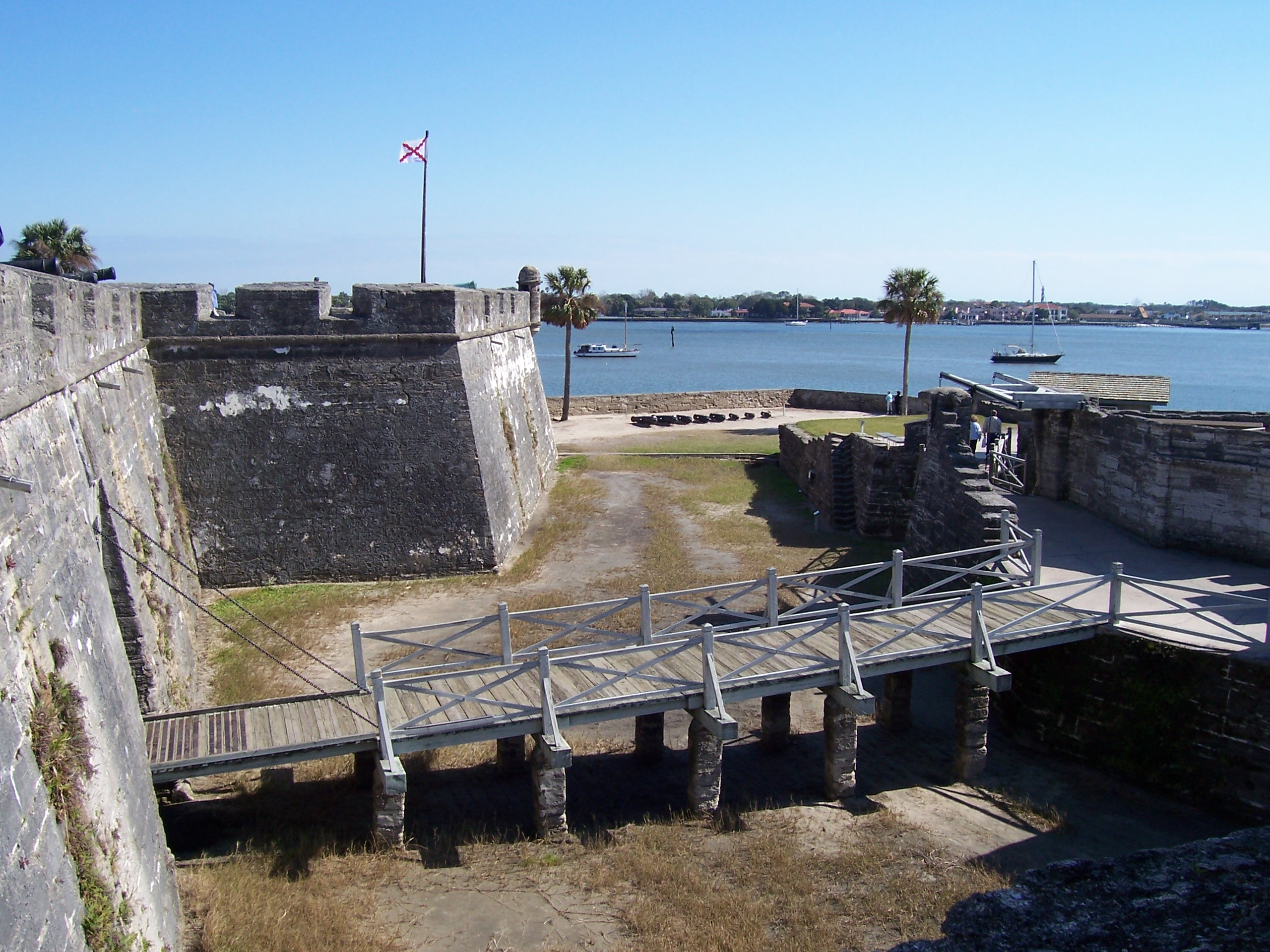
Castillo de San Marcos National Monument
National Monument
Built by the Spanish in St. Augustine to defend Florida and the Atlantic trade route, Castillo de San Marcos National Monument preserves the oldest masonry fortification in the continental United Stat...
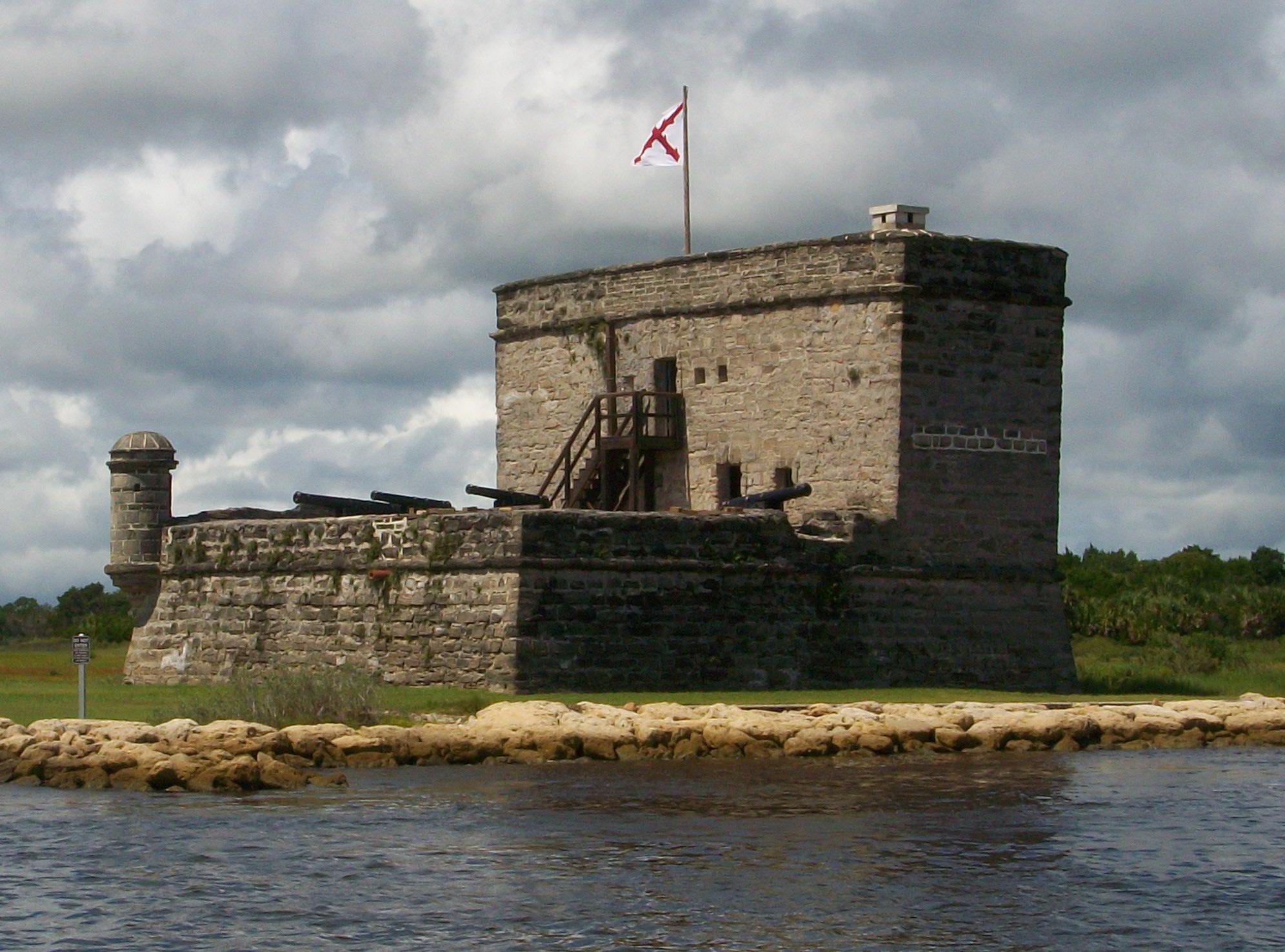
Fort Matanzas National Monument preserves the fortified coquina watchtower, completed in 1742, which defended the southern approach to the Spanish military settlement of St. Augustine. It also protect...
5 mi from route
~13 min detour
Free
near mile 53.8
Park data from the National Park Service API. Alerts update every 2 hours.
More Details
What kind of drive is this?
Expect a trip defined by a highway-heavy experience, with about 73% of your time spent on major roads like I-95, FL-19, and East State Road 40. You will encounter a longest uninterrupted stretch of 50.5 miles while navigating I-95, which requires steady focus behind the wheel. As you transition off the interstate and onto FL-19 and East State Road 40, the character of the drive shifts from high-speed transit to more localized road travel. This blend of fast-paced highway driving and secondary road navigation creates a varied rhythm for the driver. You should be prepared for the transition from the heavy traffic flow of the interstate to the more controlled pace of the state roads as you approach your destination.
73% highway — fuel and pacing are the main things to plan.
27 navigation steps total — most of the decisions cluster near the start and finish.
Longest single stretch: 50.5 mi on I 95.
How Hard Is This Drive?
7/10
This is a straightforward highway drive that stays mostly on I 95 and FL 19. This route has several spots where lane changes, forks, or exits need your full attention. The trickiest moment comes around 2 miles in near US 1.
Driving Effort7/10
Demanding - plan breaks and stay ahead of the key maneuvers
Balances navigation complexity with total wheel time.
This is a demanding drive. With 19 significant decision points across 129.9 miles, you will need to stay alert - especially through interchange areas and urban stretches. Consider splitting it into segments if you are not comfortable with fast highway navigation.
Where does it get tricky?
The main spots that need attention: at 2 miles (US 1): Highway fork - watch signs carefully. Multiple destination signs - pick the right one; at 2.3 miles: Highway fork - watch signs carefully. Lane positioning matters here; at 2.5 miles (I 95): Merge point - match speed before joining. Lane positioning matters here.
Jacksonville occupies one of the most coveted spots on the Atlantic coast. Set amongst abundant beaches and possessing an ideal subtropical climate, its crown jewel is the unique habitat and natural beauty of the St. Johns River. For this reason and more, "The River City" is a popular destination for vacationers looking for a laid-back Sunshine State escape.
Doable as a same-day drive at 2h 53m. Total distance: 129.9 miles.
Family Friendly
Moderate complexity with 1 natural rest stops along the way.
Solo Traveler
2h 53m drive, comfortable solo distance.
First-Time Driver
Mostly highway driving (73%). Some complex stretches to watch for.
Frequently Asked Questions
The longest stretch is about 50.5 miles on I 95. The full list of main roads is in the Roads section above.
It helps. This route has a higher-than-average number of complex decision points, which get harder in the dark. If the last hour of the trip is on surface roads or mountain grades, aim to arrive at Tavares, FL before sunset when you can. Check the Trip Plan for departure windows that land you in daylight.
Only with planning. This is a long drive for kids — consider splitting it into two days rather than pushing through. Plan at least 1 meaningful breaks. Dedicated rest areas are limited, so plan gas or food stops as your bathroom breaks.
The main spots that need attention: at 2 miles (US 1): Highway fork - watch signs carefully. Multiple destination signs - pick the right one; at 2.3 miles: Highway fork - watch signs carefully. Lane positioning matters here; at 2.5 miles (I 95): Merge point - match speed before joining. Lane positioning matters here.
Yes — Castillo de San Marcos National Monument and Fort Matanzas National Monument. See the National Parks section for detour distances and tips on detours.
Yes. A round trip is manageable in a single day if you plan a break at Tavares, FL before heading back.