Huntsville to Alexandria is 93 miles and takes about 2 hours and 10 minutes via Governors Drive Southeast, with a fuel budget near $14 and enough daylight to finish in a day. This trip stays within Alabama, connecting two points in the Southeast region. Expect a local drive with frequent turns rather than an open highway experience. With a short driving time and minimal highway use, this route is ideal for a relaxed day trip where you can set your own pace. Plan for a straightforward journey through familiar territory.
Trip Pace
Same-day drive is realistic
A same-day return is realistic if you keep stops short.
Midpoint
46.4 miles from Huntsville, AL
A natural place for your longest stop of the day
, about 1h 1m into the drive
.
Main Roads
Road
Distance
Duration
Governors Drive Southeast
35.5 mi
44m
Florida Short Route
28.1 mi
40m
Chastain Boulevard East
13.8 mi
16m
West Meighan Boulevard
9 mi
15m
Gunter Avenue
2.5 mi
4m
5th Avenue Northwest
1.4 mi
3m
Madison Street
0.7 mi
1m
Stadium Drive
0.7 mi
1m
Longest stretch:
Governors Drive Southeast
— 35.5 mi, about 44m
Turn-by-Turn Driving Directions
Step-by-step road directions between Huntsville, AL and Alexandria, AL.
1
Start on Spring Street Southwest
4 ft·3 sec·Spring Street Southwest
2
Turn right onto West Side Square
376 ft·9 sec·West Side Square
3
Continue on Madison Street
0.7 mi·1 min·Madison Street
4
Turn left onto US 431
35 mi·44 min·Governors Drive Southeast
Use the straight / right lanes.
5
Continue on US 431; AL 79
2.5 mi·4 min·Gunter Avenue
Use the straight / right lanes.
6
Continue on US 431
28 mi·40 min·Florida Short Route
Use the straight / right lanes.
7
Turn slight left onto 4th Street Northwest
0.5 mi·53 sec·4th Street Northwest
Use the left lane.
8
Turn right onto 5th Avenue Northwest
1.4 mi·3 min·5th Avenue Northwest
Use the straight lane.
9
Continue on US 278; US 431
9.0 mi·15 min·West Meighan Boulevard
Use the straight / right lanes.
10
Continue on US 431
14 mi·16 min·Chastain Boulevard East
Use the straight / right lanes.
11
Turn left onto CR 73
0.6 mi·1 min·Post Oak Road
12
Turn right onto Stadium Drive
0.7 mi·1 min·Stadium Drive
13
Arrive at destination
Stadium Drive
Trip Plan
Given the relatively short duration of 2 hours and 10 minutes, this trip offers significant flexibility. You can easily depart in the morning and arrive by midday, or even leave after lunch. Since there are no designated stops in the data and the drive is under 100 miles, you won't need to plan for extensive breaks. Keep an eye on your fuel gauge, as the estimated cost is $14; it's always wise to top off before departing Huntsville, especially since the longest stretch without a turn is just over 35 miles.
Morning Departure
Leave by 9 AM and you'll arrive before lunch.
Evening Departure
Even a 4 PM departure gets you there before dark in summer.
You can normally do this drive in one day.
You may only need one short stretch break if traffic stays light.
The halfway point lands around 46.4 miles from Huntsville, AL, or about 1h 1m into the drive.
The longest continuous stretch on this route runs about 35.5 miles.
This is a comfortable same-day trip.
Departure
Before you leave
Start with fuel, water, and navigation already sorted so the first hour feels easy.
First stop
Around 20 miles or 25m in
Use this first pause for coffee, a restroom break, and a quick traffic check ahead.
Halfway reset
Around 46.4 miles or 1h 1m in
This is the best place for your longest stop, a real meal, and a full fuel check.
Final approach
Final hour starts around 1h 48m
Traffic, exits, and arrival timing usually matter more near Alexandria, AL than in the middle of the route.
Before You Leave
+
Open the route before leaving Huntsville, AL so your first major turns are already loaded.
+
Leave with enough water and a charging cable within reach, not packed away.
+
Check your fuel range against the first long segment, especially if you are starting outside city service areas.
Day 1
Settle into the route from Huntsville, AL
This is one driving day of about 92.8 miles and 2h 10m.
Your first comfortable stop window is around 20 miles from Huntsville, AL.
This route can stay practical as a one-day drive if traffic stays reasonable.
The longest stretch is on Governors Drive Southeast for about 35.5 miles.
Where to Stop
Rest stops, refuel points, and overnight suggestions along this route.
Place data sourced from public business listings. Hours and availability may vary.
Heads-up: tricky spots
5 of 6
5 decision points cluster between mile 0 and 92.2 — GPS handles the exact turns, but know they're coming. Your lane choice matters more than the turn itself.
4
0 mi into trip|~0m in|West Side Square
Turn right onto West Side Square
Navigation decision point
5
0.8 mi into trip|~1m in|US 431 / Governors Drive Southeast
Turn left onto US 431 / Governors Drive Southeast
Lane positioning matters here
Use the straight / right lanes.
4
67 mi into trip|~1h 31m in|4th Street Northwest
Turn slight left onto 4th Street Northwest
Lane positioning matters here
Use the left lane.
6
67.4 mi into trip|~1h 32m in|5th Avenue Northwest
Turn right onto 5th Avenue Northwest
Lane positioning matters here
Use the straight lane.
4
92.2 mi into trip|~2h 8m in|Stadium Drive
Turn right onto Stadium Drive
Navigation decision point
Fuel & Cost
Regular Gas
$14.01 one way
$28.03 round trip
$3.84/gal25.4 MPG avg33 kg CO2
Fuel Type
$/gal
One Way
Round Trip
midgrade
$4.21
$15.39
$30.77
premium
$4.56
$16.66
$33.31
diesel
$5.61
$20.49
$40.98
No toll roads detected on this route.
Estimated Trip Cost (one way, 1 person)
Fuel
$14
Meals
$25–$50
Total
$39–$64
Rough estimate based on US averages. Hotel $80–$140/night, meals $25–$50/day.
Estimated CO2 emission: 32.5 kg one way.
Prices: EIA weekly data, 2026-04-13.
Driving Electric?
About $10 in charging
· 0 stops
· 66% less CO2
Vehicle Type
kWh
Stops
DC Fast
Home Charge
Average EV
27.8
0
$9.74
$4.45
Efficient EV
23.2
0
$8.12
$3.71
EV Truck/SUV
37.1
0
$12.99
$5.94
Gas CO2
32 kg
EV CO2
11 kg (66% less)
This trip is well within single-charge range for most EVs. No charging stops needed if you start fully charged.
DC fast charging avg $0.35/kWh. Home charging avg $0.16/kWh. US grid CO2: 0.39 kg/kWh.
Travel Intel
Current conditions at both ends of the drive.
Forecast as of Apr 15, 2026
Origin
Huntsville, AL
Morning
in Huntsville on Sunday
Local time
9:58 AM
CDT
Current temp
77°F
Unavailable
Live forecast
Destination
Alexandria, AL
Morning
in Alexandria on Sunday
Local time
9:58 AM
CDT
Current temp
85°F
Unavailable
Live forecast
Seasonal Notes
Summer travel usually means heavier construction, hotter rest stops, and busier weekend traffic around major cities.
Winter travel shortens daylight, so a route that looks manageable on paper can feel much longer after dark.
Holiday weekends tend to make both departure and arrival windows slower than the raw route time suggests.
Time zone
Same local time
Origin and destination are on the same clock, so arrival timing is easier to judge at a glance.
Temperature spread
8 degrees warmer at arrival
A meaningful temperature swing is a good cue to rethink layers, water, and how soon you want to arrive.
Road read
2h 10m on the road
Use the two city cards together: check the sky where you start, then compare it with the local time and temperature at arrival.
Weather data from the National Weather Service. Conditions may change; check closer to your travel date.
National Parks Near This Route
Worth a detour if your schedule allows.
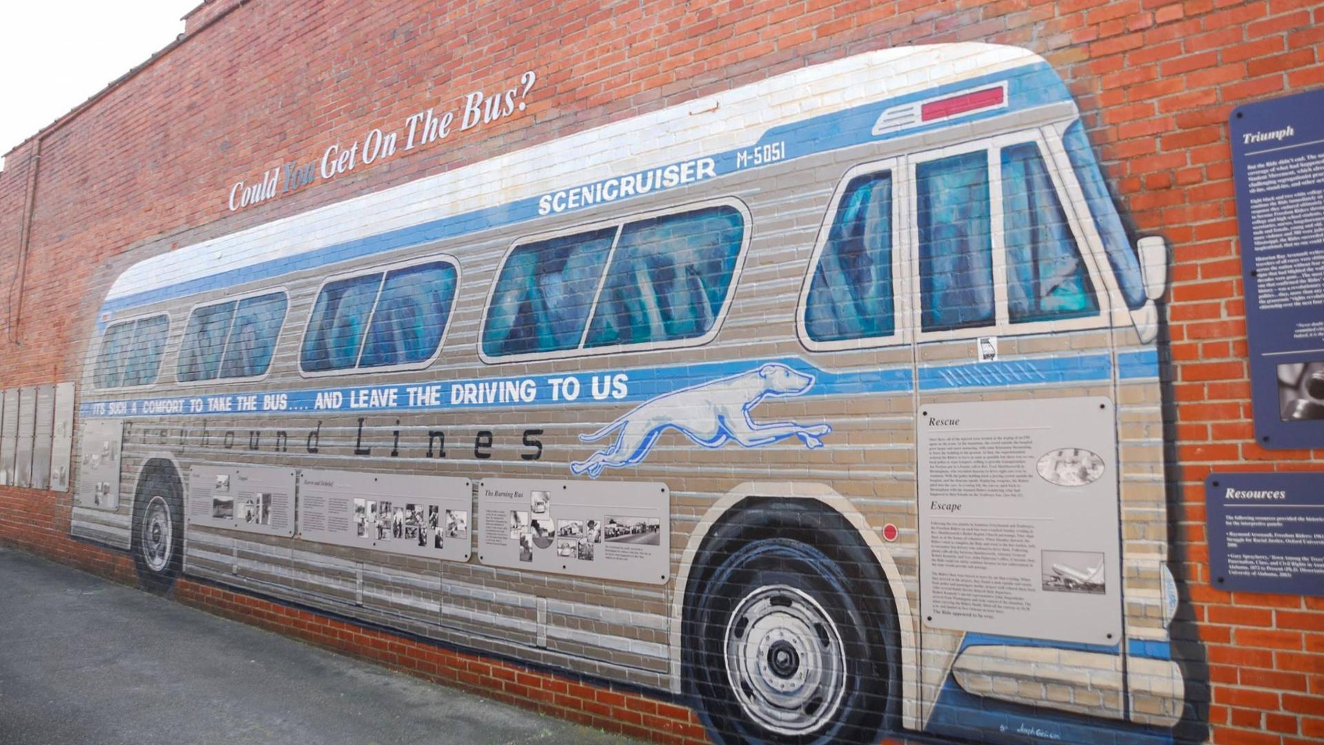
Freedom Riders National Monument
National Monument
In 1961, a small interracial band of “Freedom Riders” challenged discriminatory laws requiring separation of the races in interstate travel. They were attacked by white segregationists, who firebombed...
10 mi from route
~24 min detour
Free
near mile 92.8
Park data from the National Park Service API. Alerts update every 2 hours.
More Details
What kind of drive is this?
This route is characterized as a 'turn-heavy local drive,' with a 0% highway share. You'll be navigating primarily local roads, so be prepared for more frequent adjustments in direction. The longest uninterrupted stretch is 35.5 miles on Governors Drive Southeast, offering a brief period of consistent travel before encountering more turns. This driving profile means you'll likely experience a variety of road conditions and speeds as you move through different communities.
Only 0% highway — the rest is turn-by-turn surface driving.
13 navigation steps total — most of the decisions cluster near the start and finish.
Longest single stretch: 35.5 mi on Governors Drive Southeast.
How Hard Is This Drive?
3/10
Expect a hands-on drive with frequent turns and local roads rather than long highway stretches. There are only a few real navigation decisions along the way. The trickiest moment comes early in the drive near West Side Square.
Driving Effort3/10
Easy - simple navigation with a manageable amount of wheel time
Balances navigation complexity with total wheel time.
This is a straightforward 2h 10m drive. You will face about 6 decision points, but nothing that requires special attention if you follow navigation.
Where does it get tricky?
The main spots that need attention: near the start (West Side Square): Navigation decision point; at 0.8 miles (US 431 / Governors Drive Southeast): Lane positioning matters here; at 67 miles (4th Street Northwest): Lane positioning matters here.
Huntsville is in northern Alabama, about 20 miles (32 km) from the border with Tennessee. The city is a center for missile defense and aerospace technologies, with companies like Boeing, Lockheed Martin, Raytheon, and Northrop Grumman having major operations here. Cummings Research Park, the second largest research park in the country, is home to many of these companies.
Mostly surface roads route profile with national parks nearby.
Frequently Asked Questions
The longest stretch is about 35.5 miles on Governors Drive Southeast. The full list of main roads is in the Roads section above.
Yes, with realistic expectations. Build in a stop roughly every 2 hours, have snacks and activities ready, and check the Nearby Places tabs for kid-friendly stops along the way.
The main spots that need attention: near the start (West Side Square): Navigation decision point; at 0.8 miles (US 431 / Governors Drive Southeast): Lane positioning matters here; at 67 miles (4th Street Northwest): Lane positioning matters here.
Yes — Freedom Riders National Monument. See the National Parks section for detour distances and tips on detours.
Yes. A round trip is manageable in a single day if you plan a break at Alexandria, AL before heading back.