Spanning 228.7 miles across Southeast Georgia, this route connects Hazlehurst to Augusta in approximately 3 hours and 58 minutes. Because the drive is straightforward, it is easily manageable as a single-day trip without the need for an overnight stay. You should budget roughly $37 for fuel to complete the journey comfortably. Since both cities are located within the Southeast region, you will remain in a familiar landscape throughout your travels. It is a practical, direct path for those looking to traverse this part of the state efficiently.
Trip Pace
Same-day drive is realistic
A same-day return is possible, but it will make for a full day on the road.
Break Rhythm
1 planned break
Plan on a short reset every 3 to 4 hours to stay fresh behind the wheel.
Midpoint
110.1 miles from Hazlehurst, GA
A natural place for your longest stop of the day
, about 2h 21m into the drive
.
Main Roads
Road
Distance
Duration
I 95
77.7 mi
1h 24m
GA 21
44.2 mi
50m
Main Street
19.5 mi
26m
GA 56
15.5 mi
22m
Burnt Fort Road
12.1 mi
18m
Ocean Highway
12 mi
16m
Millhaven Road
7.5 mi
10m
GA 24
5.4 mi
7m
Longest stretch:
I 95
— 77.7 mi, about 1h 24m
Traffic on I-95
Hour-of-day weekday pattern from 20 FHWA count stations on your route.
Peak
2 PM
~2,191 veh/hr typical
· worst 3,068
Quietest
2 AM
~292 veh/hr
Peak-to-quiet ratio
7.5×
busier at peak than in the quiet hours
12a6anoon6p11p
Averaged across 52 weeks of 2023 FHWA Travel Monitoring Analysis System data. Weekday hours only (Mon–Fri).
Turn-by-Turn Driving Directions
Step-by-step road directions between Hazlehurst, GA and Augusta, GA.
1
Start on Old Hazelhurst Road
0.9 mi·3 min·Old Hazelhurst Road
2
Turn left onto Bailey Mill Road
3.3 mi·12 min·Bailey Mill Road
3
At end of road, turn right onto GA 252
7.4 mi·11 min·Burnt Fort Road
4
Continue on GA 252
4.6 mi·6 min·Burnt Fort Road
5
Turn left onto US 17; GA 25; GA 110
5.3 mi·7 min·Ocean Highway
6
Continue on US 17; GA 25
2.0 mi·2 min·US Highway 17
7
Continue on US 17; GA 25
6.7 mi·9 min·Ocean Highway
Use the left lane.
8
Turn right onto US 17; US 82; GA 25; GA 520
0.7 mi·1 min·South Georgia Parkway
9
Take the exit
0.6 mi·1 min
Toward I 95 North: Savannah
10
Merge onto I 95
68 mi·1 hr 14 min·I 95
11
Keep slight left at fork onto I 95
9.4 mi·10 min·I 95
Use the straight / slight right lanes.
12
Take the exit
0.3 mi·39 sec
Exit 109Toward GA 21: Port WentworthUse the straight / slight right lanes.
13
Keep slight left at fork
393 ft·11 sec
Toward GA 21 North, GA 30 WestUse the left lane.
14
Merge onto GA 21; GA 30; I 3 FUT
3.3 mi·3 min·Augusta Road
Use the left lane.
15
Continue on GA 21; I 3 FUT
2.2 mi·2 min·GA 21; I 3 FUT
16
Continue on GA 21; I 3 FUT
42 mi·48 min·GA 21; I 3 FUT
Use the straight lane.
17
Turn right onto GA 21 Business
1.5 mi·2 min·South Main Street
18
Continue on US 301 Business; GA 73; GA 21 Business
1.0 mi·1 min·North Main Street
19
Turn slight left onto US 301 Business; GA 73
299 ft·6 sec·US 301 Business; GA 73
20
Turn right onto US 301; GA 73 Loop
4.5 mi·5 min·US 301; GA 73 Loop
21
Take the exit onto GA 24
5.4 mi·7 min·GA 24
22
Turn right onto Millhaven Road
1.9 mi·2 min·Millhaven Road
23
Continue on Milhaven Road
1.2 mi·1 min·Milhaven Road
24
Turn straight onto Girard Millhaven Road
3.4 mi·4 min·Girard Millhaven Road
25
Continue on Millhaven Road
5.6 mi·7 min·Millhaven Road
26
Continue on GA 23
19 mi·26 min·Main Street
27
At end of road, turn right onto GA 56
15 mi·22 min·GA 56
28
Turn slight right
395 ft·17 sec
29
Continue on Old Savannah Road
0.8 mi·1 min·Old Savannah Road
30
Turn right onto US 1; US 25; US 78; US 278; GA 10; GA 121
438 ft·10 sec·Gordon Highway
31
Turn left onto Old Savannah Road
1.3 mi·3 min·Old Savannah Road
32
Turn slight left onto 12th Street
0.8 mi·2 min·12th Street
33
Turn right onto Laney Walker Boulevard
0.1 mi·19 sec·Laney Walker Boulevard
34
Turn left onto 11th Street
0.4 mi·43 sec·11th Street
35
Turn left onto Walton Way
282 ft·12 sec·Walton Way
36
Arrive at destination
Walton Way
Trip Plan
Since this is a full-day commitment, aim to depart early in the morning to maximize your daylight hours on the road. You only need to plan for one major stop, providing you with ample flexibility to stretch your legs and manage your schedule as you see fit. Given the technical, turn-heavy nature of the route, stay alert for directional changes when transitioning between Bailey Mill Road and Ocean Highway. Keep your navigation system updated to ensure you don't miss any turns on these local roads. Taking your time through the winding sections will make the nearly four-hour journey feel much more manageable.
Morning Departure
An early start around 7-8 AM gets you there with plenty of daylight left.
Evening Departure
A late afternoon start means arriving after dark. Morning is better.
You can normally do this drive in one day.
Plan roughly 1 meaningful break for fuel, food, and rest.
The halfway point lands around 110.1 miles from Hazlehurst, GA, or about 2h 21m into the drive.
The longest continuous stretch on this route runs about 77.7 miles.
This is a comfortable same-day trip.
Departure
Before you leave
Start with fuel, water, and navigation already sorted so the first hour feels easy.
First stop
Around 48 miles or 1h 13m in
Use this first pause for coffee, a restroom break, and a quick traffic check ahead.
Halfway reset
Around 110.1 miles or 2h 21m in
This is the best place for your longest stop, a real meal, and a full fuel check.
Final approach
Final hour starts around 3h 47m
Traffic, exits, and arrival timing usually matter more near Augusta, GA than in the middle of the route.
Before You Leave
+
Open the route before leaving Hazlehurst, GA so your first major turns are already loaded.
+
Leave with enough water and a charging cable within reach, not packed away.
+
Check your fuel range against the first long segment, especially if you are starting outside city service areas.
Day 1
Settle into the route from Hazlehurst, GA
This is one driving day of about 220.2 miles and 4h 46m.
Your first comfortable stop window is around 48 miles from Hazlehurst, GA.
This route can stay practical as a one-day drive if traffic stays reasonable.
Plan about 1 real break rather than only quick fuel stops.
The longest stretch is on I 95 for about 77.7 miles.
Where to Stop
Rest stops, refuel points, and overnight suggestions along this route.
Place data sourced from public business listings. Hours and availability may vary.
Heads-up: tricky spots
5 of 18
5 decision points cluster between mile 4.2 and 109.5 — GPS handles the exact turns, but know they're coming. Your lane choice matters more than the turn itself.
5
4.2 mi into trip|~16m in|GA 252 / Burnt Fort Road
At end of road, turn right onto GA 252 / Burnt Fort Road
Navigation decision point
5
31 mi into trip|~54m in
Take the exit toward I 95 North: Savannah
Exit ramp - move to the correct lane early
Toward I 95 North: Savannah
6
99.9 mi into trip|~2h 10m in|I 95
Keep slight left at fork onto I 95
Highway fork - watch signs carefully. Lane positioning matters here
Use the straight / slight right lanes.
7
109.2 mi into trip|~2h 20m in
Take the exit toward GA 21: Port Wentworth
Exit ramp - move to the correct lane early. Lane positioning matters here
Use the straight / slight right lanes.
Exit 109
Toward GA 21: Port Wentworth
9
109.5 mi into trip|~2h 21m in
Keep slight left at fork toward GA 21 North, GA 30 West
Highway fork - watch signs carefully. Lane positioning matters here. Multiple destination signs - pick the right one
Use the left lane.
Toward GA 21 North, GA 30 West
Fuel & Cost
Regular Gas
$32.51 one way
$65.02 round trip
$3.75/gal25.4 MPG avg77 kg CO2
Fuel Type
$/gal
One Way
Round Trip
midgrade
$4.12
$35.73
$71.45
premium
$4.49
$38.94
$77.88
diesel
$4.80
$41.58
$83.16
No toll roads detected on this route.
Estimated Trip Cost (one way, 1 person)
Fuel
$33
Meals
$25–$50
Total
$58–$83
Rough estimate based on US averages. Hotel $80–$140/night, meals $25–$50/day.
Estimated CO2 emission: 77 kg one way.
Prices: EIA weekly data, 2026-07-13.
Driving Electric?
About $23 in charging
· 0 stops
· 66% less CO2
Vehicle Type
kWh
Stops
DC Fast
Home Charge
Average EV
66.1
0
$23.12
$10.57
Efficient EV
55.1
0
$19.27
$8.81
EV Truck/SUV
88.1
1
$30.83
$14.09
Gas CO2
77 kg
EV CO2
26 kg (66% less)
Plan for 0 charging stops, roughly every 270 miles. Allow 25-40 minutes per stop at a DC fast charger.
DC fast charging avg $0.35/kWh. Home charging avg $0.16/kWh. US grid CO2: 0.39 kg/kWh.
Travel Intel
Current conditions at both ends of the drive.
Forecast as of Jul 18, 2026
Origin
Hazlehurst, GA
Afternoon
in Hazlehurst on Sunday
Local time
1:40 PM
EDT
Current temp
73°F
Mostly Clear
0 mph0% chanceLive forecast
Heat Advisory
Heat Advisory issued July 18 at 2:16AM EDT until July 18 at 8:00PM EDT by NWS Charleston SC
Heat Advisory
Heat Advisory issued July 18 at 2:14AM EDT until July 18 at 8:00PM EDT by NWS Columbia SC
Destination
Augusta, GA
Afternoon
in Augusta on Sunday
Local time
1:40 PM
EDT
Current temp
76°F
Partly Cloudy
0 mph6% chanceLive forecast
Heat Advisory
Heat Advisory issued July 18 at 2:16AM EDT until July 18 at 8:00PM EDT by NWS Charleston SC
Heat Advisory
Heat Advisory issued July 18 at 2:14AM EDT until July 18 at 8:00PM EDT by NWS Columbia SC
Seasonal Notes
Summer travel usually means heavier construction, hotter rest stops, and busier weekend traffic around major cities.
Winter travel shortens daylight, so a route that looks manageable on paper can feel much longer after dark.
Holiday weekends tend to make both departure and arrival windows slower than the raw route time suggests.
Time zone
Same local time
Origin and destination are on the same clock, so arrival timing is easier to judge at a glance.
Temperature spread
3 degrees warmer at arrival
A meaningful temperature swing is a good cue to rethink layers, water, and how soon you want to arrive.
Road read
4h 46m on the road
An early start around 7-8 AM gets you there with plenty of daylight left.
Weather data from the National Weather Service. Conditions may change; check closer to your travel date.
National Parks Near This Route
Worth a detour if your schedule allows.
Fort Frederica National Monument
National Monument
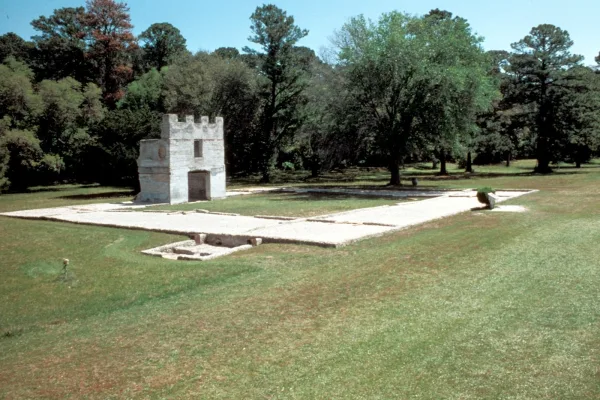
War was imminent as James Oglethorpe established Fort Frederica in 1736, to help protect the British colonies from the Spanish in Florida. Fort Frederica illustrates the story of the War of Jenkins Ea...
For much of the 19th century, masonry fortifications were the United States’ main defense against overseas enemies. However, during the Civil War, new technology proved its superiority over these fort...
19 mi from route
~47 min detour
$10
near mile 98.7
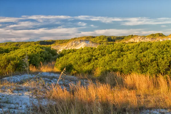
St Marys is the gateway to Cumberland Island, Georgia's largest and southernmost barrier island. Here pristine maritime forests, undeveloped beaches and wide marshes whisper the stories of both man an...
21 mi from route
~52 min detour
$15
near mile 30.4
Park data from the National Park Service API. Alerts update every 2 hours.
More Details
What kind of drive is this?
Expect a turn-heavy local drive rather than a high-speed interstate experience, as this route contains no highway mileage. You will navigate via Bailey Mill Road, Burnt Fort Road, and Ocean Highway, which shifts the focus toward local navigation rather than highway cruising. The road's personality is defined by its winding nature, requiring your full attention as you transition between these smaller routes. Without the monotony of wide-open interstates, the drive offers a more involved, hands-on experience behind the wheel. Prepare for a steady pace that favors local road awareness over rapid transit.
68% highway — fuel and pacing are the main things to plan.
36 navigation steps total — most of the decisions cluster near the start and finish.
Longest single stretch: 77.7 mi on I 95.
How Hard Is This Drive?
9/10
This is a straightforward highway drive that stays mostly on I 95 and GA 21. This route has several spots where lane changes, forks, or exits need your full attention. The trickiest moment comes around 4.2 miles in near GA 252 / Burnt Fort Road.
Driving Effort9/10
High effort - long or complex enough to need steady focus all day
Balances navigation complexity with total wheel time.
This is a demanding drive. With 18 significant decision points across 220.2 miles, you will need to stay alert - especially through interchange areas and urban stretches. Consider splitting it into segments if you are not comfortable with fast highway navigation.
Where does it get tricky?
The main spots that need attention: at 4.2 miles (GA 252 / Burnt Fort Road): Navigation decision point; at 31 miles: Exit ramp - move to the correct lane early; at 99.9 miles (I 95): Highway fork - watch signs carefully. Lane positioning matters here.
Augusta is a city in Georgia's Classic Heartland. Due to its location inland on the Savannah River, Augusta was a city of major strategic importance by the end of the Civil War. It was spared most of the destruction of many other southern cities, so there are many old buildings and landmarks. Augusta is also home to the Augusta National Golf Club, one of the world's most prestigious and exclusive golf clubs, which plays host to the Masters golf tournament.
Top landmarks
•Augusta National Golf Club — golf course in Georgia, United States
•Augusta Canal — canal in Augusta, Georgia, United States of America
•Morris Museum of Art — museum in Augusta, Georgia, USA
Doable as a same-day drive at 4h 46m. Total distance: 220.2 miles.
Family Friendly
Moderate complexity with 1 natural rest stops along the way.
Solo Traveler
4h 46m drive, comfortable solo distance.
Frequently Asked Questions
The longest stretch is about 77.7 miles on I 95. The full list of main roads is in the Roads section above.
Yes — we found about 16 rest areas or service plazas within a short detour of the route (from OpenStreetMap). See the Rest Stops tab under Nearby Places for locations and mile markers. Plan to stretch, use the bathroom, and top off fluids every 2–3 hours on longer drives.
It helps. This route has a higher-than-average number of complex decision points, which get harder in the dark. If the last hour of the trip is on surface roads or mountain grades, aim to arrive at Augusta, GA before sunset when you can. Check the Trip Plan for departure windows that land you in daylight.
Only with planning. This is a long drive for kids — consider splitting it into two days rather than pushing through. Plan at least 1 meaningful breaks. There are 16 rest areas along the route for bathroom stops.
The main spots that need attention: at 4.2 miles (GA 252 / Burnt Fort Road): Navigation decision point; at 31 miles: Exit ramp - move to the correct lane early; at 99.9 miles (I 95): Highway fork - watch signs carefully. Lane positioning matters here.
Yes — Fort Frederica National Monument, Fort Pulaski National Monument and Cumberland Island National Seashore. See the National Parks section for detour distances and tips on detours.
Possible but tiring. At 4.8 hours each way, an in-and-out day trip would put you behind the wheel for 9.6 hours — manageable with a long break at Augusta, GA, but most travelers stay overnight.