Traveling between Española and Albuquerque covers 87.9 miles, typically taking about 1 hour and 27 minutes. This trek stays entirely within the Desert Southwest, making it a straightforward journey that is easily manageable in a single day. You will navigate via Paseo de Onate, Los Alamos Highway, and Santa Clara Bridge Road rather than sticking to major interstates. With a fuel budget of approximately $13, it is an economical trip that doesn't require an overnight stop. Because this path avoids major highways entirely, it serves as a practical, local alternative for travelers looking to move between these two New Mexico hubs.
Trip Pace
Same-day drive is realistic
A same-day return is realistic if you keep stops short.
Midpoint
43.6 miles from Española, NM
A natural place for your longest stop of the day
, about 58m into the drive
.
Main Roads
Road
Distance
Duration
I 25
57 mi
58m
Santa Fe Highway
8.7 mi
13m
US 84/285
7.5 mi
8m
Taos Highway
4.7 mi
5m
South Saint Francis Drive
3.5 mi
6m
North Saint Francis Drive
2.4 mi
3m
Santa Clara Bridge Road
0.8 mi
1m
Central Avenue Northeast
0.8 mi
2m
Longest stretch:
I 25
— 57 mi, about 58m
Turn-by-Turn Driving Directions
Step-by-step road directions between Española, NM and Albuquerque, NM.
1
Start on North Paseo de Onate
9 ft·2 sec·North Paseo de Onate
2
Continue on Paseo de Onate
171 ft·19 sec·Paseo de Onate
3
Take the exit onto US 84; US 285
185 ft·5 sec·Los Alamos Highway
4
Merge onto US 84; US 285
0.2 mi·19 sec·Los Alamos Highway
5
Turn left onto US 84; US 285
0.8 mi·1 min·Santa Clara Bridge Road
6
Turn right onto US 84; US 285
0.5 mi·1 min·Riverside Drive
7
Continue on US 84; US 285
8.7 mi·13 min·Santa Fe Highway
Use the left / straight / right lanes.
8
Continue on US 84; US 285
4.7 mi·5 min·Taos Highway
Use the left / straight lanes.
9
Continue on US 84; US 285
7.5 mi·8 min·US 84/285
10
Continue on US 84; US 285
2.4 mi·3 min·North Saint Francis Drive
11
Continue on US 84; US 285
3.5 mi·6 min·South Saint Francis Drive
12
Take the exit
0.6 mi·1 min
13
Merge onto I 25
57 mi·58 min·I 25
Use the straight / slight right lanes.
14
Take the exit
0.2 mi·26 sec
Exit 224BToward Martin Luther King Junior Avenue, Central AvenueUse the slight right lane.
15
Turn straight onto Locust Street Northeast
0.3 mi·51 sec·Locust Street Northeast
16
Turn right onto Central Avenue Northeast
0.8 mi·2 min·Central Avenue Northeast
17
Arrive at destination
Central Avenue Northwest
Trip Plan
Since the trip takes under an hour and a half, you have significant flexibility with your departure time, allowing you to plan around morning or afternoon traffic. Given the lack of formal stops along these specific local roads, you should ensure your gas tank is prepared for the $13 estimated fuel cost before heading out. Keep in mind that this is a continuous, non-highway drive, so you will want to handle any necessary errands or meal breaks within Española or Albuquerque rather than along the route itself. Pack your own snacks and water, as the lack of scheduled stops means you will be behind the wheel for the duration of the 87.9-mile transit. Focus on maintaining a steady pace, as the turn-heavy nature of the roads makes this route less about speed and more about careful navigation.
Morning Departure
Leave by 9 AM and you'll arrive before lunch.
Evening Departure
Even a 4 PM departure gets you there before dark in summer.
You can normally do this drive in one day.
You may only need one short stretch break if traffic stays light.
The halfway point lands around 43.6 miles from Española, NM, or about 58m into the drive.
The longest continuous stretch on this route runs about 57 miles.
This is a comfortable same-day trip.
Departure
Before you leave
Start with fuel, water, and navigation already sorted so the first hour feels easy.
First stop
Around 19 miles or 27m in
Use this first pause for coffee, a restroom break, and a quick traffic check ahead.
Halfway reset
Around 43.6 miles or 58m in
This is the best place for your longest stop, a real meal, and a full fuel check.
Final approach
Final hour starts around 1h 29m
Traffic, exits, and arrival timing usually matter more near Albuquerque, NM than in the middle of the route.
Before You Leave
+
Open the route before leaving Española, NM so your first major turns are already loaded.
Day 1
Settle into the route from Española, NM
This is one driving day of about 87.1 miles and 1h 45m.
Your first comfortable stop window is around 19 miles from Española, NM.
This route can stay practical as a one-day drive if traffic stays reasonable.
The longest stretch is on I 25 for about 57 miles.
Where to Stop
Rest stops, refuel points, and overnight suggestions along this route.
Place data sourced from public business listings. Hours and availability may vary.
Heads-up: tricky spots
5 of 8
5 decision points cluster between mile 0 and 85.8 — GPS handles the exact turns, but know they're coming. Your lane choice matters more than the turn itself.
4
0 mi into trip|~0m in|US 84; US 285 / Los Alamos Highway
Take the exit onto US 84; US 285 / Los Alamos Highway
Exit ramp - move to the correct lane early
4
0.1 mi into trip|~0m in|US 84; US 285 / Los Alamos Highway
Merge onto US 84; US 285 / Los Alamos Highway
Merge point - match speed before joining
4
0.2 mi into trip|~0m in|US 84; US 285 / Santa Clara Bridge Road
Turn left onto US 84; US 285 / Santa Clara Bridge Road
Navigation decision point
5
28.8 mi into trip|~42m in|I 25
Merge onto I 25
Merge point - match speed before joining. Lane positioning matters here
Use the straight / slight right lanes.
8
85.8 mi into trip|~1h 41m in
Take the exit toward Martin Luther King Junior Avenue, Central Avenue
Exit ramp - move to the correct lane early. Lane positioning matters here. Multiple destination signs - pick the right one
Use the slight right lane.
Exit 224B
Toward Martin Luther King Junior Avenue, Centra...
Fuel & Cost
Regular Gas
$13.15 one way
$26.31 round trip
$3.84/gal25.4 MPG avg31 kg CO2
Fuel Type
$/gal
One Way
Round Trip
midgrade
$4.21
$14.44
$28.88
premium
$4.56
$15.63
$31.27
diesel
$5.61
$19.23
$38.46
No toll roads detected on this route.
Estimated Trip Cost (one way, 1 person)
Fuel
$13
Meals
$25–$50
Total
$38–$63
Rough estimate based on US averages. Hotel $80–$140/night, meals $25–$50/day.
Estimated CO2 emission: 30.5 kg one way.
Prices: EIA weekly data, 2026-04-13.
Driving Electric?
About $9 in charging
· 0 stops
· 67% less CO2
Vehicle Type
kWh
Stops
DC Fast
Home Charge
Average EV
26.1
0
$9.15
$4.18
Efficient EV
21.8
0
$7.62
$3.48
EV Truck/SUV
34.8
0
$12.19
$5.57
Gas CO2
30 kg
EV CO2
10 kg (67% less)
This trip is well within single-charge range for most EVs. No charging stops needed if you start fully charged.
DC fast charging avg $0.35/kWh. Home charging avg $0.16/kWh. US grid CO2: 0.39 kg/kWh.
Travel Intel
Current conditions at both ends of the drive.
Forecast as of Apr 16, 2026
Origin
Española, NM
Late night
in Española on Tuesday
Local time
3:01 AM
MDT
Current temp
71°F
Unavailable
Live forecast
Destination
Albuquerque, NM
Late night
in Albuquerque on Tuesday
Local time
3:01 AM
MDT
Current temp
79°F
Mostly Sunny
S 5 to 15 mph0% chanceLive forecast
66°F
Santa Fe, NM
44 mi in
Seasonal Notes
Summer travel usually means heavier construction, hotter rest stops, and busier weekend traffic around major cities.
Winter travel shortens daylight, so a route that looks manageable on paper can feel much longer after dark.
Holiday weekends tend to make both departure and arrival windows slower than the raw route time suggests.
Time zone
Same local time
Origin and destination are on the same clock, so arrival timing is easier to judge at a glance.
Temperature spread
8 degrees warmer at arrival
A meaningful temperature swing is a good cue to rethink layers, water, and how soon you want to arrive.
Road read
1h 45m on the road
The weather snapshot is not static. If you are leaving later, give both cities one more quick forecast check before departure.
Weather data from the National Weather Service. Conditions may change; check closer to your travel date.
National Parks Near This Route
Worth a detour if your schedule allows.
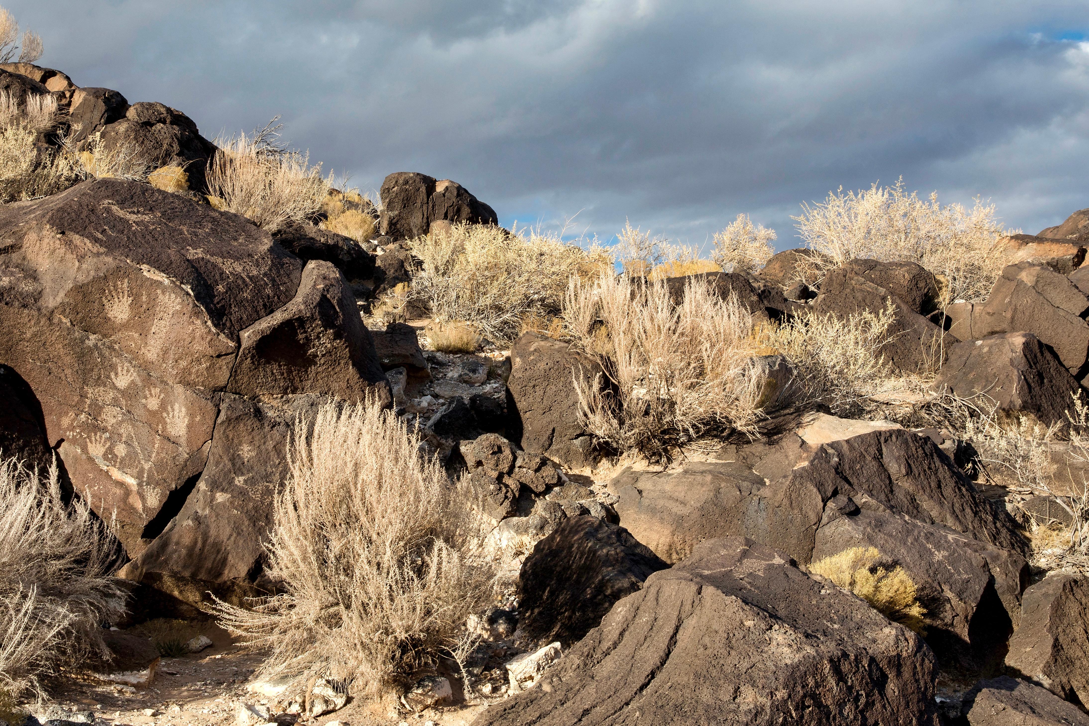
Petroglyph National Monument
National Monument
Petroglyph National Monument protects one of the largest petroglyph sites in North America, featuring designs and symbols carved onto volcanic rocks by Native Americans and Spanish settlers 400 to 700...
7 mi from route
~17 min detour
Free
near mile 87.1
Caution: Be City Smart: Take precautions to secure your vehicle and valuables.
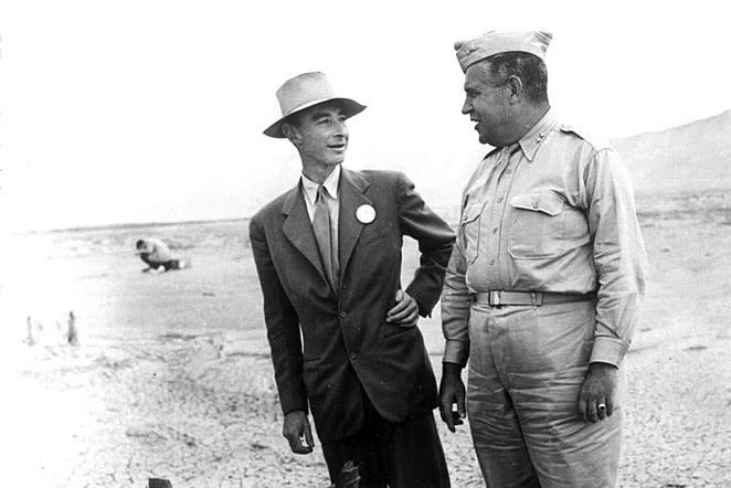
The Manhattan Project is one of the most transformative events of the 20th century. It ushered in the nuclear age with the development of the world’s first atomic bombs. Most of this development took...
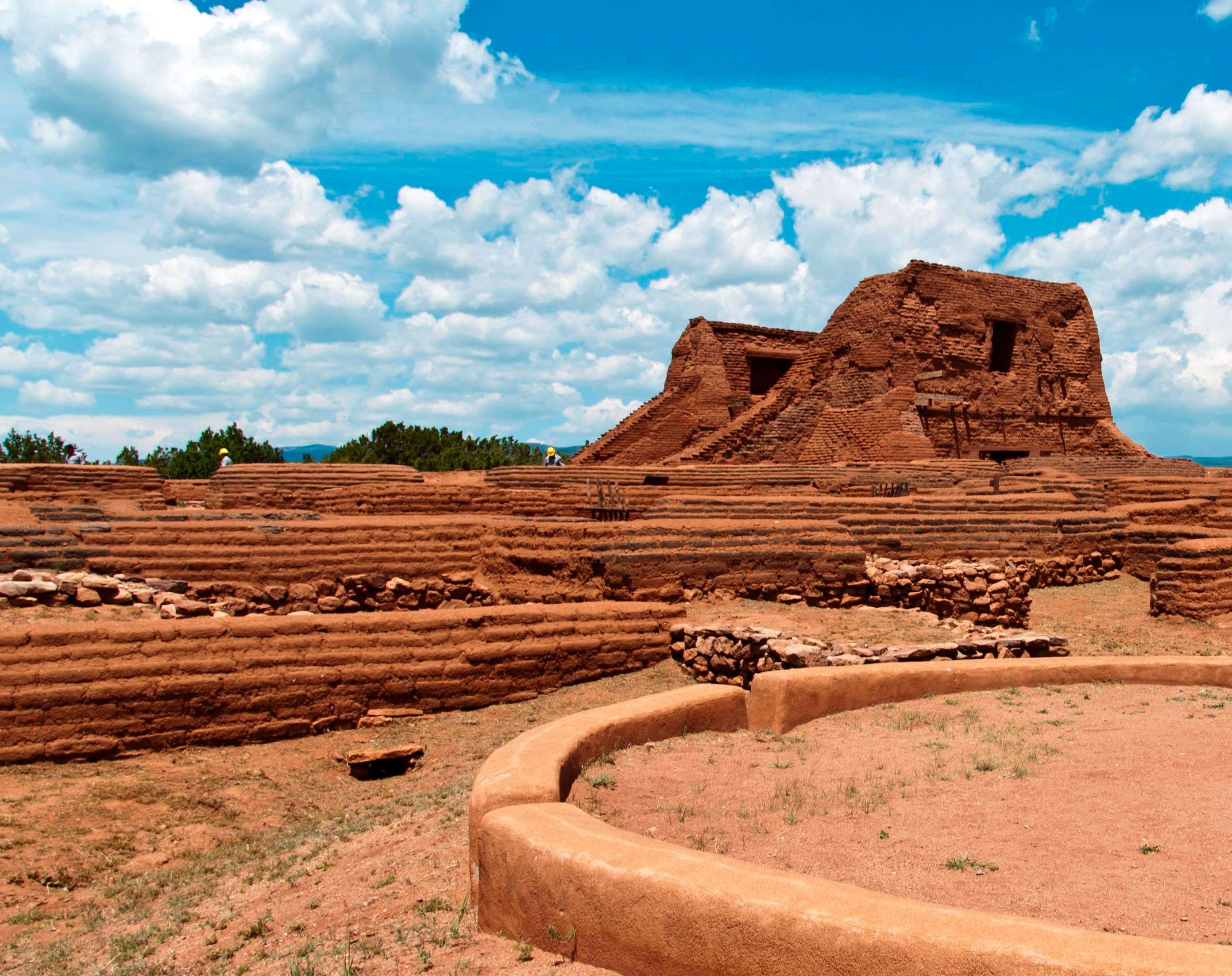
Pecos is a natural and cultural crossroads through which hunters, gatherers, traders, missionaries, immigrants, soldiers, ranchers, and other travelers passed and lived. Follow in their footsteps and...
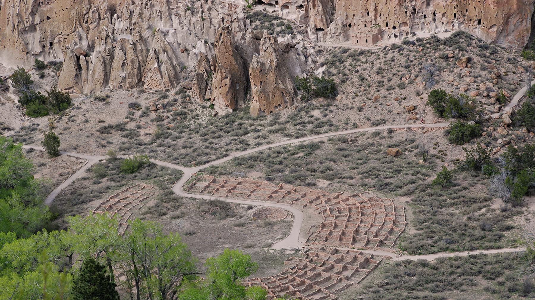
Bandelier National Monument protects over 33,000 acres of ruggedly beautiful canyon and mesa country. Petroglyphs, dwellings carved into the soft rock cliffs, and standing masonry walls pay tribute to...
Park data from the National Park Service API. Alerts update every 2 hours.
More Details
What kind of drive is this?
Expect a turn-heavy local drive rather than a monotonous interstate cruise, as this route features 0% highway share. You will navigate winding local roads that demand your full attention, setting a deliberate pace that feels quite different from high-speed transit. Because the route relies on local connectors like Paseo de Onate and Santa Clara Bridge Road, the experience is defined by constant maneuvering rather than long, uninterrupted stretches. This is a technical drive that keeps you engaged with the road layout from start to finish. If you enjoy hands-on driving through the high desert, this path offers a refreshing change of pace from standard highway travel.
74% highway — fuel and pacing are the main things to plan.
17 navigation steps total — most of the decisions cluster near the start and finish.
Longest single stretch: 57 mi on I 25.
How Hard Is This Drive?
6/10
This is a straightforward highway drive that stays mostly on I 25 and Santa Fe Highway. You will hit about 8 points where you need to pay attention to lane position or signs. The trickiest moment comes early in the drive near US 84; US 285 / Los Alamos Highway.
Driving Effort6/10
Moderate - straightforward overall, but long enough or busy enough to require pacing
Balances navigation complexity with total wheel time.
This drive requires moderate attention. Across 87.1 miles you will encounter 8 spots where lane choice or exit timing matters. Not difficult for experienced highway drivers, but worth previewing the tricky sections before you go.
Where does it get tricky?
The main spots that need attention: near the start (US 84; US 285 / Los Alamos Highway): Exit ramp - move to the correct lane early; at 0.1 miles (US 84; US 285 / Los Alamos Highway): Merge point - match speed before joining; at 0.2 miles (US 84; US 285 / Santa Clara Bridge Road): Navigation decision point.
Española is a small, predominately Hispanic city of 10,000 people (2018). Española has few tourist attractions of its own and isn't much to look at from the main roads — passing through, what you'll see is mostly strip malls and gas stations — but its location midway between Santa Fe and Taos, combined with its proximity to a number of Pueblo Indian communities, makes the town a useful staging point for trips around the region.
For the town in Spain, see Alburquerque
Albuquerque, also known as ABQ, is a vibrant, sprawling city near the center of New Mexico. Cradled in the Rio Grande Valley beneath the Sandia Mountains, it is by far the largest city in the state, acting as the media, educational, and economic center of New Mexico, as well as the home of the state's only major airport, making it a common entry point into New Mexico. Despite this, Albuquerque is often overshadowed as a tourist destination by Santa Fe, 60 miles (97 km) to the north.
But any visit to New Mexico would be incomplete without taking in what Albuquerque has to offer, as New Mexico's only major city has pleasant scenery, colorful history, and a wealth of great attractions in its own right.
Doable as a same-day drive at 1h 45m. Total distance: 87.1 miles.
Family Friendly
Moderate complexity with 0 natural rest stops along the way.
Solo Traveler
1h 45m drive, comfortable solo distance.
First-Time Driver
Mostly highway driving (74%). Some complex stretches to watch for.
Frequently Asked Questions
The longest stretch is about 57 miles on I 25. The full list of main roads is in the Roads section above.
It helps. This route has a higher-than-average number of complex decision points, which get harder in the dark. If the last hour of the trip is on surface roads or mountain grades, aim to arrive at Albuquerque, NM before sunset when you can. Check the Trip Plan for departure windows that land you in daylight.
Yes. At under 2 hours behind the wheel, this works well for families — plan one quick stop if you have younger kids.
Mostly yes along the main roads, but rural stretches through NM can have sparse or no coverage. Before you leave, download offline Google Maps or Apple Maps for the route, and consider downloading music or podcasts instead of streaming. If you depend on data for navigation, keep a paper backup of the turn-by-turn directions.
The main spots that need attention: near the start (US 84; US 285 / Los Alamos Highway): Exit ramp - move to the correct lane early; at 0.1 miles (US 84; US 285 / Los Alamos Highway): Merge point - match speed before joining; at 0.2 miles (US 84; US 285 / Santa Clara Bridge Road): Navigation decision point.
Yes — Petroglyph National Monument, Manhattan Project National Historical Park and Pecos National Historical Park (4 total within detour distance). See the National Parks section for detour distances and tips on detours.
Yes. A round trip is manageable in a single day if you plan a break at Albuquerque, NM before heading back.