Origin
Erin, TN
Late night in Erin on Tuesday
Local time
3:47 AM
CDT
Current temp
76°F
Unavailable
Live forecast
Compiled and reviewed by the US Trip Planner planning team at COD Solutions Oy · Last reviewed Apr 21, 2026 · Editorial standards
Drive Time
1h 34m
Distance
65.1 mi
105 km
Drive Score
9/10
Great drive
Same Day?
Yes, doable
Fuel Cost
$10
one way
EV Charging
Unknown
Estimated drive times based on typical traffic patterns. Actual times may vary with weather, construction, and real-time conditions.

Erin, TN
Wikimedia Commons

Franklin, TN
Wikimedia Commons
If you are looking to travel from Erin to Franklin, Tennessee, you are in for a 65.8-mile journey that typically takes about 1 hour and 30 minutes. This trip is perfectly suited as a single-day excursion, meaning you won't need to worry about overnight logistics. Budgeting around $10 for fuel should cover your transit across this Southeast corridor. Because the route relies entirely on local roads, you will avoid the high-speed monotony of the interstate system. This is a straightforward, practical connection between two Tennessee communities that offers a departure from typical highway travel.
Trip Pace
Same-day drive is realistic
A same-day return is realistic if you keep stops short.
Midpoint
32.6 miles from Erin, TN
A natural place for your longest stop of the day , about 54m into the drive .
| Road | Distance | Duration |
|---|---|---|
| Yellow Creek Road | 14.1 mi | 24m |
| State Highway 96 | 11.8 mi | 14m |
| I 40 | 9.2 mi | 9m |
| East Main Street | 5.2 mi | 8m |
| Fairview Boulevard | 5.2 mi | 5m |
| TN 49 | 5.2 mi | 7m |
| Highway 96 | 4.8 mi | 6m |
| SR 46 | 4.6 mi | 6m |
Step-by-step road directions between Erin, TN and Franklin, TN.
Start on Spring Street
Turn right onto SR 49
Continue on TN 49
Turn right onto SR 46
Continue on SR 46
Turn left onto US 70
Continue on US 70 Business
Turn right onto SR 46
Take the exit
Merge onto I 40
Take the exit
Turn left onto TN 96
Merge onto SR 96; SR 100
Take the exit
Turn right onto TN 96
Continue on Bridge Street
Turn right onto 3rd Avenue North
Enter roundabout onto US 31 Business; TN 96
Arrive at destination
Since this is a relatively short 1.5-hour trip, you have the flexibility to leave whenever suits your schedule best. You won't need to plan for any formal stops along the way, as the duration is manageable in one go. Keep in mind that because the route consists entirely of local roads, you should factor in extra time if you encounter slow-moving traffic or local transit patterns. Given the turn-heavy profile of the path, ensure your vehicle is ready for frequent steering adjustments. Your best bet is to check your GPS before departing to stay current on any local road conditions along your specific path.
Morning Departure
Leave by 9 AM and you'll arrive before lunch.
Evening Departure
Even a 4 PM departure gets you there before dark in summer.
This is a comfortable same-day trip.
Departure
Before you leave
Start with fuel, water, and navigation already sorted so the first hour feels easy.
First stop
Around 14 miles or 22m in
Use this first pause for coffee, a restroom break, and a quick traffic check ahead.
Halfway reset
Around 32.6 miles or 54m in
This is the best place for your longest stop, a real meal, and a full fuel check.
Final approach
Final hour starts around 1h 21m
Traffic, exits, and arrival timing usually matter more near Franklin, TN than in the middle of the route.
Open the route before leaving Erin, TN so your first major turns are already loaded.
Day 1
Settle into the route from Erin, TN
This is one driving day of about 65.1 miles and 1h 34m.
Rest stops, refuel points, and overnight suggestions along this route.

Mid-route town
Meal stop
33 mi into the route
Best for: Lunch, fuel, and a longer reset
This sits close to the middle of the route, so it works well for the longest stop of the day.
A short stop after about 14 miles helps settle the day before fatigue starts building.
The midpoint is around 32.6 miles from Erin, TN, which is a good place for a longer meal and fuel stop.
These stop ideas are pacing suggestions — the exact town or exit can change with traffic, hotel plans, and fuel range.
5 decision points cluster between mile 28.7 and 65 — GPS handles the exact turns, but know they're coming. Your lane choice matters more than the turn itself.
Turn right onto SR 46
Lane positioning matters here
Take the exit
Exit ramp - move to the correct lane early. Lane positioning matters here
Take the exit toward Primary SR 96: Fairview, Franklin
Exit ramp - move to the correct lane early. Lane positioning matters here. Multiple destination signs - pick the right one
Turn right onto TN 96 / State Highway 96
Lane positioning matters here
Turn right onto 3rd Avenue North
Lane positioning matters here
Regular Gas
$10.18 one way
$20.36 round trip
| Fuel Type | $/gal | One Way | Round Trip |
|---|---|---|---|
| midgrade | $4.36 | $11.17 | $22.35 |
| premium | $4.89 | $12.53 | $25.06 |
| diesel | $5.61 | $14.37 | $28.75 |
No toll roads detected on this route.
Estimated Trip Cost (one way, 1 person)
Fuel
$10
Meals
$25–$50
Total
$35–$60
Rough estimate based on US averages. Hotel $80–$140/night, meals $25–$50/day.
Estimated CO2 emission: 22.8 kg one way. Prices: EIA weekly data, 2026-04-13.
Driving Electric?
About $7 in charging · 0 stops · 65% less CO2
| Vehicle Type | kWh | Stops | DC Fast | Home Charge |
|---|---|---|---|---|
| Average EV | 19.5 | 0 | $6.84 | $3.12 |
| Efficient EV | 16.3 | 0 | $5.70 | $2.60 |
| EV Truck/SUV | 26 | 0 | $9.11 | $4.17 |
Gas CO2
23 kg
EV CO2
8 kg (65% less)
This trip is well within single-charge range for most EVs. No charging stops needed if you start fully charged.
DC fast charging avg $0.35/kWh. Home charging avg $0.16/kWh. US grid CO2: 0.39 kg/kWh.
Current conditions at both ends of the drive.
Origin
Late night in Erin on Tuesday
Local time
3:47 AM
CDT
Current temp
76°F
Unavailable
Destination
Late night in Franklin on Tuesday
Local time
3:47 AM
CDT
Current temp
76°F
Unavailable
56°F
Burns, TN
33 mi in
Seasonal Notes
Summer travel usually means heavier construction, hotter rest stops, and busier weekend traffic around major cities.
Winter travel shortens daylight, so a route that looks manageable on paper can feel much longer after dark.
Holiday weekends tend to make both departure and arrival windows slower than the raw route time suggests.
Time zone
Origin and destination are on the same clock, so arrival timing is easier to judge at a glance.
Temperature spread
Both ends of the route are sitting at about the same temperature right now.
Road read
Use the two city cards together: check the sky where you start, then compare it with the local time and temperature at arrival.
Weather data from the National Weather Service. Conditions may change; check closer to your travel date.
Worth a detour if your schedule allows.
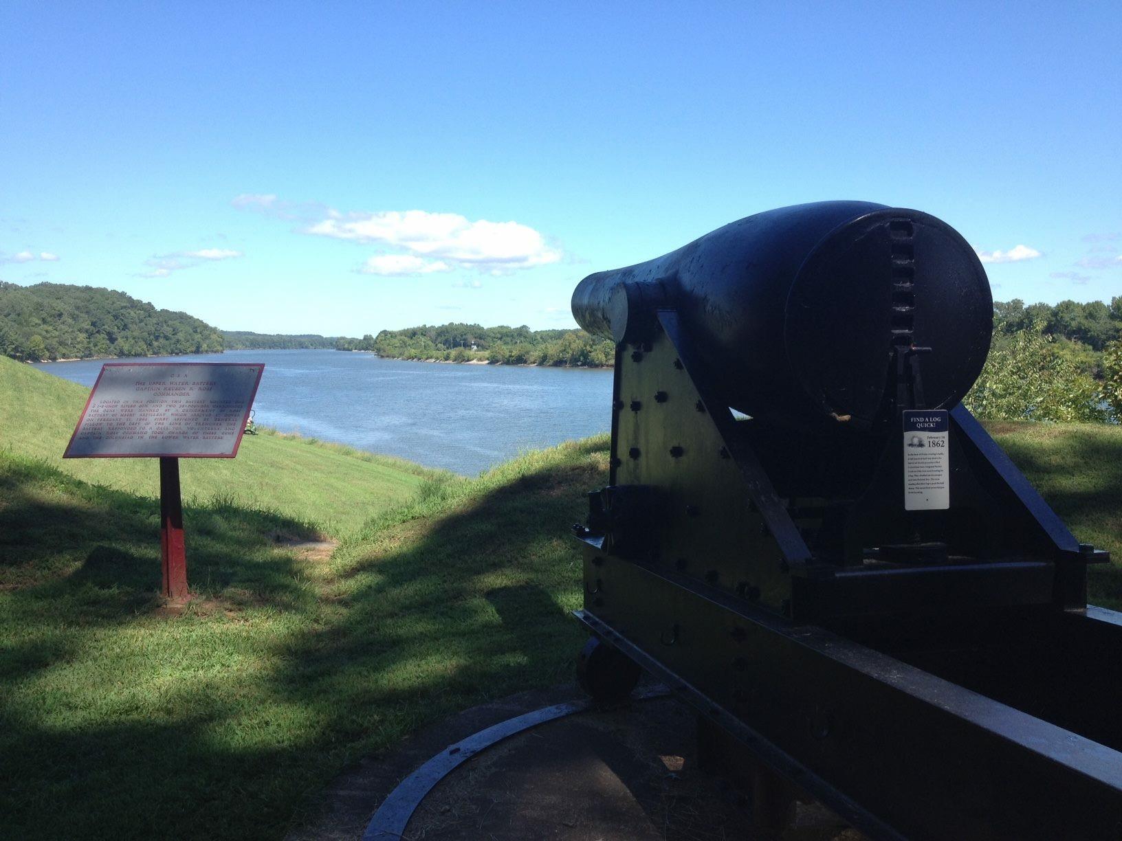
National Battlefield
Brigadier General Ulysses S. Grant was becoming quite famous as he wrote these words following the surrender of Confederate Fort Donelson on Sunday, February 16, 1862. The Union victory at Fort Donels...

National Battlefield
The Battle of Stones River began on the last day of 1862 and became one of the bloodiest conflicts of the Civil War. The battle produced important military and political gains for the Union, and it ch...
Park data from the National Park Service API. Alerts update every 2 hours.
Expect a turn-heavy local drive rather than a straight-line interstate sprint, as this route features zero highway miles. You will navigate through local thoroughfares including East Main Street, Yellow Creek Road, and Pond Road. While there is no long-distance highway cruising, the road requires your full attention due to its winding, technical nature. You will not find any long, uninterrupted stretches here, as the longest segment is 0 miles on East Main Street. Prepare for a more engaged, hands-on driving experience that focuses on local navigation.
This route mixes highway mileage with some local-road sections near the start or finish. You will hit about 12 points where you need to pay attention to lane position or signs. The trickiest moment comes around 28.7 miles in near SR 46.
Moderate - straightforward overall, but long enough or busy enough to require pacing
Balances navigation complexity with total wheel time.
This drive requires moderate attention. Across 65.1 miles you will encounter 12 spots where lane choice or exit timing matters. Not difficult for experienced highway drivers, but worth previewing the tricky sections before you go.
Where does it get tricky?
The main spots that need attention: at 28.7 miles (SR 46): Lane positioning matters here; at 33.3 miles: Exit ramp - move to the correct lane early. Lane positioning matters here; at 42.8 miles: Exit ramp - move to the correct lane early. Lane positioning matters here. Multiple destination signs - pick the right one.
Based on OSRM destination-sign hints, not a full list of every settlement the road passes.
On the drive from Erin, TN to Franklin, TN, road signs begin pointing toward Primary Sr 96: Fairview along the way.
Primary Sr 96: Fairview
Franklin is a city of 81,000 people (2018) in Tennessee, just a few miles south of Nashville. There are two main areas of interest. One is the Cool Springs area, which is identified by its corporate and retail growth surrounding one of the largest malls in the Southeast, the CoolSprings Galleria. The other is historic downtown Franklin which retains much of its small town charm. It is a walkable, friendly historic downtown district, recognized as a Great American Main Street.
City content from Wikivoyage (CC BY-SA 4.0) and Wikidata (CC0).
Weekend Trip
Doable as a same-day drive at 1h 34m. Total distance: 65.1 miles.
Family Friendly
Moderate complexity with 0 natural rest stops along the way.
Solo Traveler
1h 34m drive, comfortable solo distance.
First-Time Driver
Mostly highway driving (55%). Some complex stretches to watch for.
Scenic Drive
Mixed highway & surface route profile with national parks nearby.
Compiled by the US Trip Planner planning team at COD Solutions Oy from open government datasets — OSRM over OpenStreetMap for geometry, EIA for fuel prices, and NPS for national parks. See our methodology for refresh cadence and limitations.
Was this helpful?
Thanks for your feedback!
Your tip has been submitted. Thanks!
/500
Recent Tips
·
Explore more options from Erin, TN or browse trips ending in Franklin, TN.
Looking for more statewide routes? Browse TN road trips.