Origin
Endwell, NY
Late night in Endwell on Sunday
Local time
12:17 AM
EDT
Current temp
41°F
Unavailable
Live forecast
Compiled and reviewed by the US Trip Planner planning team at COD Solutions Oy · Last reviewed Apr 19, 2026 · Editorial standards
Drive Time
2h 11m
Distance
94.1 mi
151 km
Drive Score
8/10
Great drive
Same Day?
Yes, doable
Fuel Cost
$15
one way
EV Charging
Unknown
Estimated drive times based on typical traffic patterns. Actual times may vary with weather, construction, and real-time conditions.

Endwell, NY
Renan Tagliaferro

Utica, NY
Wikimedia Commons
This 94.1-mile journey from Endwell, NY to Utica, NY is a straightforward, highway-focused drive that can easily be completed in a single day. Expect to spend about 2 hours and 11 minutes on the road, with a fuel cost estimated at $15. The route primarily utilizes State Highway 12 and the Southern Tier Expressway, offering a direct connection within the Northeast region. With no specified stops, this trip is ideal for those seeking an efficient drive to their destination without the need for an overnight stay. It's a practical option for a day trip, allowing you to reach Utica with plenty of time to spare.
Trip Pace
Same-day drive is realistic
A same-day return is realistic if you keep stops short.
Midpoint
47 miles from Endwell, NY
A natural place for your longest stop of the day , about 1h into the drive .
| Road | Distance | Duration |
|---|---|---|
| State Highway 12 | 51.8 mi | 1h 6m |
| State Route 12 | 15.5 mi | 23m |
| Southern Tier Expressway | 3.7 mi | 5m |
| North-South Arterial Highway | 3.6 mi | 4m |
| Front Street | 2.9 mi | 3m |
| I 81 | 2.3 mi | 3m |
| New Paris Road | 2.1 mi | 3m |
| South Broad Street | 1.7 mi | 3m |
Step-by-step road directions between Endwell, NY and Utica, NY.
Start on this road
Turn right onto Norton Avenue
At end of road, turn left onto Watson Boulevard
Turn right onto CR 33
Turn right onto NY 17C
Continue on NY 17C
Take the ramp
Merge onto NY 17
Take the exit
Merge onto I 81
Keep slight left at fork onto I 81
Take the exit
Turn right onto US 11
Continue on NY 12
Continue on NY 12
Continue on NY 12
Continue on NY 12
Continue on NY 12
Continue on NY 12
Continue on NY 12
Turn slight right onto NY 12
Continue on NY 12
Continue on NY 12
Continue on NY 12
Turn left onto NY 12
Continue on NY 12
Continue on NY 12
Continue on NY 12
Continue on NY 12
Turn left onto NY 12
Turn right onto NY 5; NY 12
Take the exit
Keep slight right at fork
Turn slight right onto Court Street
Turn left onto Genesee Street
Turn left onto Washington Lane
Arrive at destination
Given the relatively short duration of 2 hours and 11 minutes, you have the flexibility to depart at your convenience. Consider leaving in the morning to maximize your time in Utica. With a fuel cost around $15, it's an economical trip, but it's always wise to start with a full tank. While there are no designated stops in the data, keep an eye out for rest areas along the Southern Tier Expressway if needed. The longest stretch without a break is over 50 miles on State Highway 12, so plan for a brief pause before or after that segment if you prefer.
Morning Departure
Leave by 9 AM and you'll arrive before lunch.
Evening Departure
Even a 4 PM departure gets you there before dark in summer.
This is a comfortable same-day trip.
Departure
Before you leave
Start with fuel, water, and navigation already sorted so the first hour feels easy.
First stop
Around 21 miles or 29m in
Use this first pause for coffee, a restroom break, and a quick traffic check ahead.
Halfway reset
Around 47 miles or 1h in
This is the best place for your longest stop, a real meal, and a full fuel check.
Final approach
Final hour starts around 1h 45m
Traffic, exits, and arrival timing usually matter more near Utica, NY than in the middle of the route.
Open the route before leaving Endwell, NY so your first major turns are already loaded.
Leave with enough water and a charging cable within reach, not packed away.
Check your fuel range against the first long segment, especially if you are starting outside city service areas.
Day 1
Settle into the route from Endwell, NY
This is one driving day of about 94.1 miles and 2h 11m.
Rest stops, refuel points, and overnight suggestions along this route.

Mid-route town
Meal stop
47 mi into the route
Best for: Lunch, fuel, and a longer reset
This sits close to the middle of the route, so it works well for the longest stop of the day.
A short stop after about 21 miles helps settle the day before fatigue starts building.
The midpoint is around 47 miles from Endwell, NY, which is a good place for a longer meal and fuel stop.
These stop ideas are pacing suggestions — the exact town or exit can change with traffic, hotel plans, and fuel range.
5 decision points cluster between mile 0.2 and 9.3 — GPS handles the exact turns, but know they're coming. Your lane choice matters more than the turn itself.
At end of road, turn left onto Watson Boulevard
Complex interchange - multiple decisions in a short stretch
Turn right onto CR 33 / Hooper Road
Lane positioning matters here
Take the exit toward I 81 North: Syracuse, Albany
Exit ramp - move to the correct lane early. Multiple destination signs - pick the right one
Keep slight left at fork onto I 81 toward I 81 North: Syracuse
Highway fork - watch signs carefully
Take the exit toward US 11: Nimmonsburg, Chenango Bridge
Exit ramp - move to the correct lane early. Multiple destination signs - pick the right one
Regular Gas
$15.49 one way
$30.98 round trip
| Fuel Type | $/gal | One Way | Round Trip |
|---|---|---|---|
| midgrade | $4.52 | $16.75 | $33.50 |
| premium | $4.92 | $18.24 | $36.48 |
| diesel | $5.61 | $20.78 | $41.55 |
No toll roads detected on this route.
Estimated Trip Cost (one way, 1 person)
Fuel
$15
Meals
$25–$50
Total
$40–$65
Rough estimate based on US averages. Hotel $80–$140/night, meals $25–$50/day.
Estimated CO2 emission: 32.9 kg one way. Prices: EIA weekly data, 2026-04-13.
Driving Electric?
About $10 in charging · 0 stops · 67% less CO2
| Vehicle Type | kWh | Stops | DC Fast | Home Charge |
|---|---|---|---|---|
| Average EV | 28.2 | 0 | $9.88 | $4.52 |
| Efficient EV | 23.5 | 0 | $8.23 | $3.76 |
| EV Truck/SUV | 37.6 | 0 | $13.17 | $6.02 |
Gas CO2
33 kg
EV CO2
11 kg (67% less)
This trip is well within single-charge range for most EVs. No charging stops needed if you start fully charged.
DC fast charging avg $0.35/kWh. Home charging avg $0.16/kWh. US grid CO2: 0.39 kg/kWh.
Current conditions at both ends of the drive.
Origin
Late night in Endwell on Sunday
Local time
12:17 AM
EDT
Current temp
41°F
Unavailable
Destination
Late night in Utica on Sunday
Local time
12:17 AM
EDT
Current temp
41°F
Unavailable
38°F
Norwich, NY
47 mi in
Seasonal Notes
Summer travel usually means heavier construction, hotter rest stops, and busier weekend traffic around major cities.
Winter travel shortens daylight, so a route that looks manageable on paper can feel much longer after dark.
Holiday weekends tend to make both departure and arrival windows slower than the raw route time suggests.
Time zone
Origin and destination are on the same clock, so arrival timing is easier to judge at a glance.
Temperature spread
Both ends of the route are sitting at about the same temperature right now.
Road read
Use the two city cards together: check the sky where you start, then compare it with the local time and temperature at arrival.
Weather data from the National Weather Service. Conditions may change; check closer to your travel date.
Worth a detour if your schedule allows.
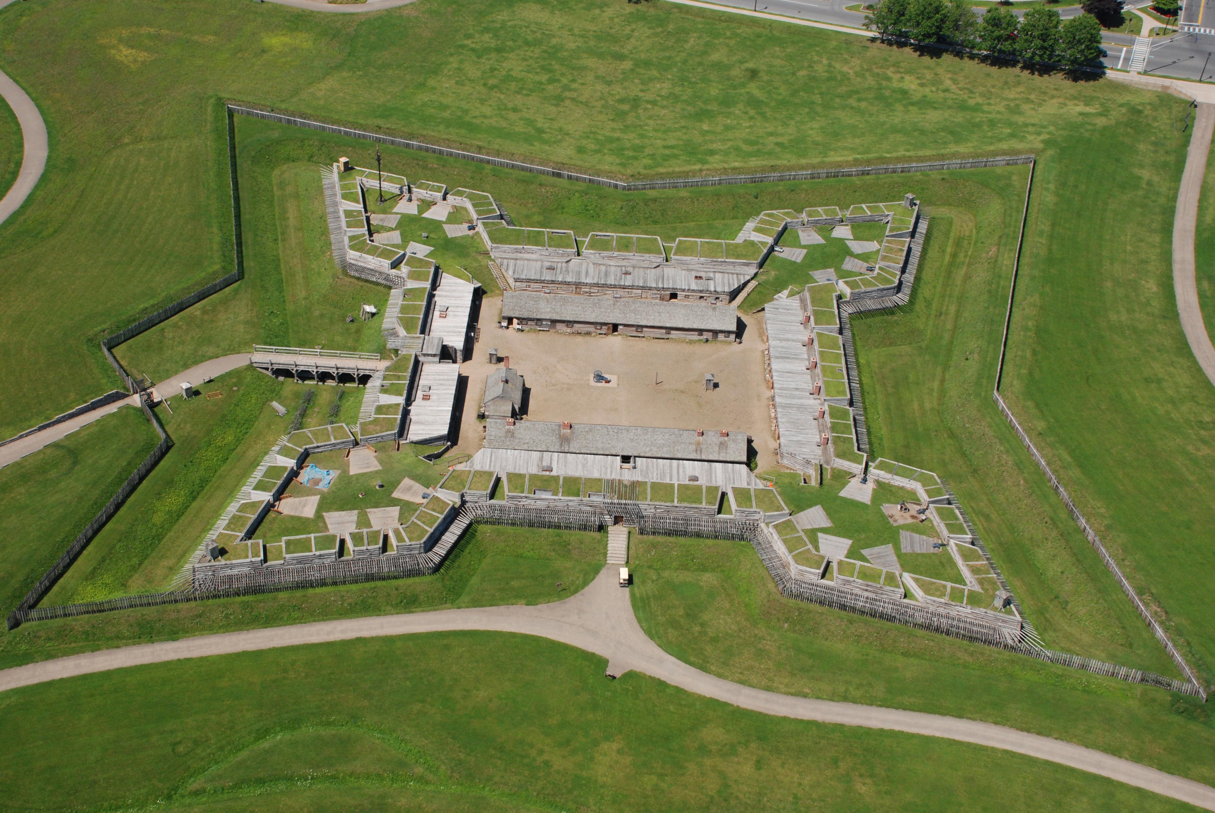
National Monument
For centuries, the Oneida Carrying Place, a six-mile portage connecting the Mohawk River and Wood Creek, served as a vital link for those traveling by water from the ocean to the Great Lakes. When Eur...
Park data from the National Park Service API. Alerts update every 2 hours.
Your drive will be heavily influenced by highway travel, with 78% of the route on major roadways like State Highway 12 and the Southern Tier Expressway. You'll experience a significant stretch of 51.8 miles on State Highway 12 without interruption, indicating a consistent and uninterrupted driving experience for a substantial portion of the trip. This highway-focused profile suggests a generally fast-paced journey, allowing you to cover ground efficiently. The road character remains largely consistent, making it a predictable and easy-to-navigate route.
This is a straightforward highway drive that stays mostly on State Highway 12 and State Route 12. This route has several spots where lane changes, forks, or exits need your full attention. The trickiest moment comes around 0.2 miles in near Watson Boulevard.
Demanding - plan breaks and stay ahead of the key maneuvers
Balances navigation complexity with total wheel time.
This is a demanding drive. With 16 significant decision points across 94.1 miles, you will need to stay alert - especially through interchange areas and urban stretches. Consider splitting it into segments if you are not comfortable with fast highway navigation.
Where does it get tricky?
The main spots that need attention: at 0.2 miles (Watson Boulevard): Complex interchange - multiple decisions in a short stretch; at 0.3 miles (CR 33 / Hooper Road): Lane positioning matters here; at 6 miles: Exit ramp - move to the correct lane early. Multiple destination signs - pick the right one.
Based on OSRM destination-sign hints, not a full list of every settlement the road passes.
On the drive from Endwell, NY to Utica, NY, road signs begin pointing toward Albany along the way.
Albany
Founded 1734
Utica is the heart of the Mohawk Valley and the seat of Oneida County in Central New York State. Utica offers the charm of small-city living balanced with the cultural and ethnic diversity of an international urban center. At the foot of the Adirondack Mountains, Utica is a truly scenic city that offers the pleasures of both a rural and urban setting.
Top landmarks
City content from Wikivoyage (CC BY-SA 4.0) and Wikidata (CC0).
Weekend Trip
Doable as a same-day drive at 2h 11m. Total distance: 94.1 miles.
Family Friendly
Moderate complexity with 0 natural rest stops along the way.
Solo Traveler
2h 11m drive, comfortable solo distance.
First-Time Driver
Mostly highway driving (78%). Some complex stretches to watch for.
Compiled by the US Trip Planner planning team at COD Solutions Oy from open government datasets — OSRM over OpenStreetMap for geometry, EIA for fuel prices, and NPS for national parks. See our methodology for refresh cadence and limitations.
Was this helpful?
Thanks for your feedback!
Your tip has been submitted. Thanks!
/500
Recent Tips
·
Explore more options from Endwell, NY or browse trips ending in Utica, NY.
Looking for more statewide routes? Browse NY road trips.