Traveling from Denver to Cortez covers 378.5 miles and typically takes about 8 hours and 39 minutes of time behind the wheel. Because of the duration, this trip is best approached as a two-day journey rather than a single day of driving. You will rely primarily on West Hampden Avenue and US 160 to navigate through the Mountain West. Budgeting roughly $57 for fuel will keep you moving along this route. While it is certainly feasible to complete in one push, splitting the drive into two days allows you to manage the distance more comfortably. Planning your travel across these regions requires a realistic look at your endurance and the time required to reach your destination.
Trip Pace
Best split across 2 days
Treat the return leg as its own travel day rather than an afterthought.
Break Rhythm
2 planned breaks
Plan on a short reset every 3 to 4 hours to stay fresh behind the wheel.
Midpoint
189.3 miles from Denver, CO
A natural place for your longest stop of the day
, about 4h 17m into the drive
.
Main Roads
Road
Distance
Duration
West Hampden Avenue
110.8 mi
2h 24m
US 160
101.6 mi
2h 15m
West U.S. Highway 160
57.8 mi
1h 20m
US 285
44.6 mi
1h 8m
US 50
40.4 mi
51m
West Highway 112
13.1 mi
19m
San Juan Street
2.6 mi
4m
South Santa Fe Drive
2.3 mi
2m
Longest stretch:
West Hampden Avenue
— 110.8 mi, about 2h 24m
Turn-by-Turn Driving Directions
Step-by-step road directions between Denver, CO and Cortez, CO.
1
Start on this road
379 ft·29 sec·this road
2
Turn right
62 ft·8 sec
3
Turn right onto I 70 Business; US 40; US 287
358 ft·14 sec·East Colfax Avenue
4
Turn right onto Grant Street
1.1 mi·2 min·Grant Street
Use the right lane.
5
Turn left onto East Speer Boulevard
451 ft·13 sec·East Speer Boulevard
Use the left lane.
6
Turn right onto Logan Street
0.8 mi·1 min·Logan Street
Use the right lane.
7
Turn right onto East Alameda Avenue
0.3 mi·49 sec·East Alameda Avenue
8
Turn left onto South Broadway
1.6 mi·2 min·South Broadway
Use the straight lane.
9
Turn right onto West Iowa Avenue
0.2 mi·35 sec·West Iowa Avenue
10
At end of road, turn left onto US 85
2.3 mi·2 min·South Santa Fe Drive
Use the left lane.
11
Take the exit
0.2 mi·35 sec
Toward US 285 SouthUse the slight right lane.
12
Merge onto US 285
111 mi·2 hr 24 min·West Hampden Avenue
Use the straight / slight right lanes.
13
At end of road, turn left onto US 285
11 mi·17 min·US 285
14
Continue on US 285
10.0 mi·16 min·US 285
15
Turn left onto US 50; US 285
40 mi·51 min·US 50; US 285
Use the straight lane.
16
Turn slight left onto US 285
24 mi·34 min·US 285
Use the straight / left lanes.
17
Turn right onto CO 112
13 mi·19 min·West Highway 112
Use the right lane.
18
Turn right onto US 160
0.6 mi·1 min·Grand Avenue
19
Continue on US 160
58 mi·1 hr 20 min·West U.S. Highway 160
20
Continue on US 160
2.6 mi·4 min·San Juan Street
21
Continue on US 160
11 mi·14 min·US 160
Use the straight lane.
22
Continue on US 160
46 mi·1 hr·US 160
Use the straight lane.
23
Take the exit onto US 160
0.1 mi·24 sec·US 160
Use the left lane.
24
At end of road, turn left onto US 160
45 mi·1 hr 1 min·US 160
Use the left lane.
25
Turn right onto North Market Street
193 ft·10 sec·North Market Street
Use the straight / right lanes.
26
Turn left
213 ft·15 sec
27
Arrive at destination
Trip Plan
To keep your energy high, plan for at least two intentional stops during your 378.5-mile trek. Since you are facing a long day on the road, departing early in the morning is your best strategy to avoid fatigue. Keep a close eye on your fuel gauge, keeping in mind the estimated $57 cost to ensure you reach Cortez without stress. Given the 8-hour and 39-minute duration, use the two recommended stops to stretch and reset your focus. A practical tip for this specific route is to prioritize your fuel stops before tackling the longest 110.8-mile stretch, as this ensures you maintain momentum without unnecessary detours.
Morning Departure
Start early — leave by 6-7 AM to arrive at a reasonable hour.
Evening Departure
This is a long drive — plan for a morning departure or consider splitting it into two days.
This drive is better paced as a 2-day trip.
Plan roughly 2 meaningful breaks for fuel, food, and rest.
The halfway point lands around 189.3 miles from Denver, CO, or about 4h 17m into the drive.
The longest continuous stretch on this route runs about 110.8 miles.
Consider an overnight stop or starting very early.
Departure
Before you leave
Start with fuel, water, and navigation already sorted so the first hour feels easy.
First stop
Around 83 miles or 1h 52m in
Use this first pause for coffee, a restroom break, and a quick traffic check ahead.
Halfway reset
Around 189.3 miles or 4h 17m in
This is the best place for your longest stop, a real meal, and a full fuel check.
Overnight split
Day 1 wrap after about 189.3 miles or 4h 17m
Stop before fatigue turns the last few hours into a grind. You want day two to start fresh, not just resumed.
Final approach
Final hour starts around 7h 18m
Traffic, exits, and arrival timing usually matter more near Cortez, CO than in the middle of the route.
Before You Leave
+
Open the route before leaving Denver, CO so your first major turns are already loaded.
+
Leave with enough water and a charging cable within reach, not packed away.
+
Check your fuel range against the first long segment, especially if you are starting outside city service areas.
+
Pick one backup stop option before the midpoint in case traffic changes your pacing.
+
Treat this as a 2-day road trip and book the overnight stop before the busiest arrival window.
Day 1
Settle into the route from Denver, CO
Aim for roughly 189 miles and 4.3 hours of wheel time on this day.
Day 2
Finish the approach into Cortez, CO
Aim for roughly 189 miles and 4.3 hours of wheel time on this day.
Your first comfortable stop window is around 83 miles from Denver, CO.
This route usually feels better as a 2-day drive than as one long push.
Plan about 2 real breaks rather than only quick fuel stops.
The longest stretch is on West Hampden Avenue for about 110.8 miles.
Where to Stop
Rest stops, refuel points, and overnight suggestions along this route.
Place data sourced from public business listings. Hours and availability may vary.
Heads-up: tricky spots
5 of 20
5 decision points cluster between mile 0.2 and 333.6 — GPS handles the exact turns, but know they're coming. Your lane choice matters more than the turn itself.
6
0.2 mi into trip|~0m in|Grant Street
Turn right onto Grant Street
Lane positioning matters here
Use the right lane.
6
2.4 mi into trip|~6m in|South Broadway
Turn left onto South Broadway
Lane positioning matters here
Use the straight lane.
6
6.6 mi into trip|~12m in
Take the exit toward US 285 South
Exit ramp - move to the correct lane early. Lane positioning matters here
Use the slight right lane.
Toward US 285 South
6
202.7 mi into trip|~4h 37m in|CO 112 / West Highway 112
Turn right onto CO 112 / West Highway 112
Lane positioning matters here
Use the right lane.
6
333.6 mi into trip|~7h 38m in|US 160
At end of road, turn left onto US 160
Lane positioning matters here
Use the left lane.
Fuel & Cost
Regular Gas
$57.03 one way
$114.06 round trip
$3.83/gal25.4 MPG avg132 kg CO2
Fuel Type
$/gal
One Way
Round Trip
midgrade
$4.05
$60.38
$120.76
premium
$4.39
$65.48
$130.96
diesel
$5.61
$83.57
$167.14
No toll roads detected on this route.
Estimated Trip Cost (one way, 1 person)
Fuel
$57
Hotel (1n)
$80–$140
Meals
$50–$100
Total
$187–$297
Rough estimate based on US averages. Hotel $80–$140/night, meals $25–$50/day.
Estimated CO2 emission: 132.4 kg one way.
Prices: EIA weekly data, 2026-04-13.
Driving Electric?
About $40 in charging
· 1 stop
· 67% less CO2
Vehicle Type
kWh
Stops
DC Fast
Home Charge
Average EV
113.6
1
$39.74
$18.17
Efficient EV
94.6
1
$33.12
$15.14
EV Truck/SUV
151.4
1
$52.99
$24.22
Gas CO2
132 kg
EV CO2
44 kg (67% less)
Plan for 1 charging stop. A 30-minute DC fast charge mid-route should be enough to complete the trip comfortably.
DC fast charging avg $0.35/kWh. Home charging avg $0.16/kWh. US grid CO2: 0.39 kg/kWh.
Travel Intel
Current conditions at both ends of the drive.
Forecast as of Apr 15, 2026
Origin
Denver, CO
Evening
in Denver on Saturday
Local time
7:26 PM
MDT
Current temp
46°F
Unavailable
Live forecast
Destination
Cortez, CO
Evening
in Cortez on Saturday
Local time
7:26 PM
MDT
Current temp
74°F
Unavailable
Live forecast
Seasonal Notes
Summer travel usually means heavier construction, hotter rest stops, and busier weekend traffic around major cities.
Winter travel shortens daylight, so a route that looks manageable on paper can feel much longer after dark.
Holiday weekends tend to make both departure and arrival windows slower than the raw route time suggests.
For long drives, weather on day two can matter just as much as conditions at departure, so check the whole travel window rather than only the first day.
Time zone
Same local time
Origin and destination are on the same clock, so arrival timing is easier to judge at a glance.
Temperature spread
28 degrees warmer at arrival
A meaningful temperature swing is a good cue to rethink layers, water, and how soon you want to arrive.
Road read
8h 39m on the road
This is long enough that the arrival forecast matters almost as much as departure conditions. Recheck both ends before you roll.
Weather data from the National Weather Service. Conditions may change; check closer to your travel date.
National Parks Near This Route
Worth a detour if your schedule allows.
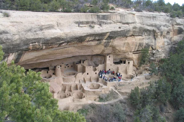
Mesa Verde National Park
National Park
For over 700 years, the Ancestral Pueblo people built thriving communities on the mesas and in the cliffs of Mesa Verde. Today, the park protects the rich cultural heritage of 27 Pueblos and Tribes an...
8 mi from route
~20 min detour
$30
near mile 365.5
Caution: Park Hours may Change due to Winter Storms
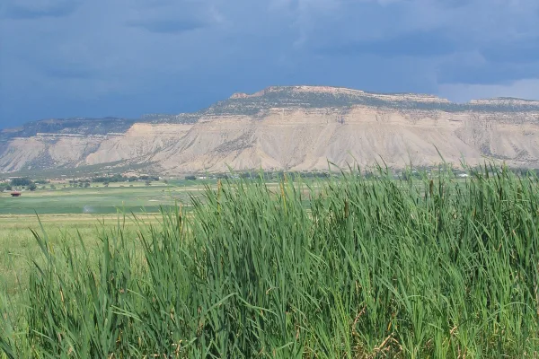
Yucca House National Monument preserves a large unexcavated pueblo with a stunning setting in Montezuma Valley, nestled between Mesa Verde and Ute Mountain. Since Yucca House was protected as a nation...
9 mi from route
~22 min detour
Free
near mile 378.5
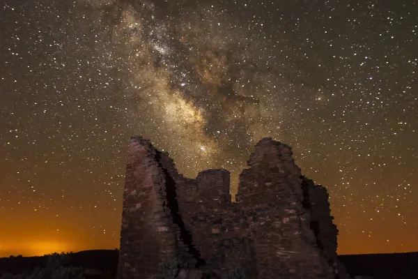
Hovenweep preserves six prehistoric sites built between 1200 and 1300 CE which may have served as ceremonial centers. Explore a variety of structures, including multistory towers perched on canyon rim...
23 mi from route
~58 min detour
$20
near mile 378.5
Park data from the National Park Service API. Alerts update every 2 hours.
More Details
What kind of drive is this?
This journey is a highway-focused drive, with 68% of your travel occurring on major roadways. You will spend a significant portion of your time on West Hampden Avenue, which accounts for the longest uninterrupted stretch of 110.8 miles. As you transition from the metro area toward Cortez, the road character shifts from localized thoroughfares to the more consistent flow of US 160. Expect a mix of fast highway stretches that demand your attention over the nearly nine-hour transit. Navigating these roads requires a steady focus as you cross through the diverse terrain of Colorado.
68% highway — fuel and pacing are the main things to plan.
27 navigation steps total — most of the decisions cluster near the start and finish.
Longest single stretch: 110.8 mi on West Hampden Avenue.
How Hard Is This Drive?
4/10
This is a straightforward highway drive that stays mostly on West Hampden Avenue and US 160. There are only a few real navigation decisions along the way. The trickiest moment comes around 0.2 miles in near Grant Street.
Driving Effort4/10
Easy - simple navigation with a manageable amount of wheel time
Balances navigation complexity with total wheel time.
The route itself is not hard, but at 8h 39m, endurance matters. Plan breaks every 2-3 hours. The 20 decision points are all manageable with basic attention.
Where does it get tricky?
The main spots that need attention: at 0.2 miles (Grant Street): Lane positioning matters here; at 2.4 miles (South Broadway): Lane positioning matters here; at 6.6 miles: Exit ramp - move to the correct lane early. Lane positioning matters here.
Elevation Profile
Mountain driving with significant elevation changes
Denver is the capital of the western U.S. state of Colorado and the dominant city of the Rocky Mountain Region. Founded in 1858 as the placer gold mining camp known as the Cherry Creek Diggings, the "Mile-High City" is today the most populous city within a 560-mile (900 km) radius and the center of the Front Range Urban Corridor of more than five million residents. Denver embraces its cowboy and mining past but also looks toward the future with a vibrant arts and performing arts scene, dozens of great outdoor festivals, and distinct neighborhoods each offering a unique experience. You'll find everything a cosmopolitan city has to offer including a spectacular view of and easy access to the beautiful Rocky Mountains, which arise only 12 miles (19 km) west of the Colorado State Capitol.
The longest stretch is about 110.8 miles on West Hampden Avenue. The full list of main roads is in the Roads section above.
Yes — a 2-day pace is more comfortable than one long haul. A sensible stopping point is after roughly 189 miles on day one.
We did not find dedicated rest areas on this route. For a drive this long, plan bathroom and stretch breaks around gas stations, fast-food stops, or small-town downtowns — check the Nearby Places section for options.
It helps. This is a long drive, so arriving tired and in the dark compounds. If the last hour of the trip is on surface roads or mountain grades, aim to arrive at Cortez, CO before sunset when you can. Check the Trip Plan for departure windows that land you in daylight.
Only with planning. This is a long drive for kids — consider splitting it into two days rather than pushing through. Plan at least 2 meaningful breaks. Dedicated rest areas are limited, so plan gas or food stops as your bathroom breaks.
The main spots that need attention: at 0.2 miles (Grant Street): Lane positioning matters here; at 2.4 miles (South Broadway): Lane positioning matters here; at 6.6 miles: Exit ramp - move to the correct lane early. Lane positioning matters here.
Yes — Mesa Verde National Park, Yucca House National Monument and Hovenweep National Monument. See the National Parks section for detour distances and tips on detours.
Not recommended in a single day. At 8.7 hours each way, a round trip means 17.3 hours of driving — that is an unsafe level of fatigue for most drivers. Plan at least one night at Cortez, CO before the return drive.