Connecting Collinsville to Decatur, this 105.7-mile journey through Alabama takes approximately 2 hours and 9 minutes to complete. Because the trip is relatively short, it functions perfectly as a single-day excursion, requiring no overnight stops. You should budget about $16 for fuel to cover the distance comfortably. Utilizing a mix of John T Reid Parkway, I-59, and Tammy Little Drive, the route stays entirely within the Southeast region. This is a straightforward, highway-focused drive that is ideal for travelers looking for an efficient transit between these two Alabama communities.
Trip Pace
Same-day drive is realistic
A same-day return is realistic if you keep stops short.
Midpoint
52.9 miles from Collinsville, AL
A natural place for your longest stop of the day
, about 1h 6m into the drive
.
Main Roads
Road
Distance
Duration
John T Reid Parkway
59.3 mi
1h 8m
I 59
13.1 mi
14m
Tammy Little Drive
12.7 mi
17m
East Main Street
8.9 mi
12m
Glenn Boulevard Southwest
3.8 mi
5m
Huntsville-Decatur Highway
3.5 mi
4m
Bee Line Highway
1.6 mi
2m
AL 68
1.2 mi
2m
Longest stretch:
John T Reid Parkway
— 59.3 mi, about 1h 8m
Turn-by-Turn Driving Directions
Step-by-step road directions between Collinsville, AL and Decatur, AL.
1
Start on 1st Avenue
73 ft·5 sec·1st Avenue
2
Turn right onto West Main Street
0.1 mi·28 sec·West Main Street
3
Continue on AL 68
1.2 mi·2 min·AL 68
4
Take the ramp
0.2 mi·28 sec
5
Merge onto I 59
13 mi·14 min·I 59
6
Take the exit
0.3 mi·33 sec
Exit 218Toward 35: Fort Payne, Rainsville
7
Turn left onto AL 35
3.8 mi·5 min·Glenn Boulevard Southwest
8
Continue on AL 35
8.9 mi·12 min·East Main Street
9
Continue on AL 35
13 mi·17 min·Tammy Little Drive
10
Turn left
0.2 mi·33 sec
Toward US 72, AL 279
11
Merge onto US 72; AL 279
59 mi·1 hr 8 min·John T Reid Parkway
12
Continue on US 72 Alternate; SR 20
0.1 mi·8 sec·US 72 Alternate; SR 20
13
Continue on US 72 Alternate; AL 20
3.5 mi·4 min·Huntsville-Decatur Highway
Use the right lane.
14
Continue on US 31; US 72 Alternate; AL 20
1.6 mi·2 min·Bee Line Highway
15
Keep slight left at fork onto US 31; US 72 Alternate; AL 20
0.4 mi·50 sec·6th Avenue Northeast
Use the straight lane.
16
Turn right onto Lee Street Northeast
0.2 mi·32 sec·Lee Street Northeast
Use the straight / right lanes.
17
Turn right
82 ft·6 sec
18
Arrive at destination
Trip Plan
Since this is a manageable 105.7-mile trek, you have plenty of flexibility in your departure time to avoid potential traffic congestion. Given that there are zero mandatory stops on this 2-hour and 9-minute route, you can easily complete it in one go without needing to refuel mid-trip. If you prefer a relaxed pace, consider leaving mid-morning to ensure you arrive in Decatur well before your evening plans. Keep in mind that the majority of your time is spent on I-59 and John T Reid Parkway, so staying alert during the 59.3-mile stretch is your best strategy for a smooth arrival. Prioritize filling your tank before you leave Collinsville to take full advantage of your $16 fuel budget.
Morning Departure
Leave by 9 AM and you'll arrive before lunch.
Evening Departure
Even a 4 PM departure gets you there before dark in summer.
You can normally do this drive in one day.
You may only need one short stretch break if traffic stays light.
The halfway point lands around 52.9 miles from Collinsville, AL, or about 1h 6m into the drive.
The longest continuous stretch on this route runs about 59.3 miles.
This is a comfortable same-day trip.
Departure
Before you leave
Start with fuel, water, and navigation already sorted so the first hour feels easy.
First stop
Around 23 miles or 28m in
Use this first pause for coffee, a restroom break, and a quick traffic check ahead.
Halfway reset
Around 52.9 miles or 1h 6m in
This is the best place for your longest stop, a real meal, and a full fuel check.
Final approach
Final hour starts around 1h 45m
Traffic, exits, and arrival timing usually matter more near Decatur, AL than in the middle of the route.
Before You Leave
+
Open the route before leaving Collinsville, AL so your first major turns are already loaded.
+
Leave with enough water and a charging cable within reach, not packed away.
+
Check your fuel range against the first long segment, especially if you are starting outside city service areas.
Day 1
Settle into the route from Collinsville, AL
This is one driving day of about 105.7 miles and 2h 9m.
Your first comfortable stop window is around 23 miles from Collinsville, AL.
This route can stay practical as a one-day drive if traffic stays reasonable.
The longest stretch is on John T Reid Parkway for about 59.3 miles.
Where to Stop
Rest stops, refuel points, and overnight suggestions along this route.
Place data sourced from public business listings. Hours and availability may vary.
Heads-up: tricky spots
5 of 10
5 decision points cluster between mile 0 and 105.5 — GPS handles the exact turns, but know they're coming. Your lane choice matters more than the turn itself.
5
0 mi into trip|~0m in|West Main Street
Turn right onto West Main Street
Navigation decision point
6
14.6 mi into trip|~17m in
Take the exit toward 35: Fort Payne, Rainsville
Exit ramp - move to the correct lane early. Multiple destination signs - pick the right one
Exit 218
Toward 35: Fort Payne, Rainsville
5
40.3 mi into trip|~51m in
Turn left toward US 72, AL 279
Multiple destination signs - pick the right one
Toward US 72, AL 279
6
105.1 mi into trip|~2h 8m in|US 31; US 72 Alternate; AL 20 / 6th Avenue Northeast
Keep slight left at fork onto US 31; US 72 Alternate; AL 20 / 6th Avenue Northeast
Highway fork - watch signs carefully. Lane positioning matters here
Use the straight lane.
5
105.5 mi into trip|~2h 8m in|Lee Street Northeast
Turn right onto Lee Street Northeast
Lane positioning matters here
Use the straight / right lanes.
Fuel & Cost
Regular Gas
$15.96 one way
$31.93 round trip
$3.84/gal25.4 MPG avg37 kg CO2
Fuel Type
$/gal
One Way
Round Trip
midgrade
$4.21
$17.52
$35.05
premium
$4.56
$18.97
$37.94
diesel
$5.61
$23.34
$46.67
No toll roads detected on this route.
Estimated Trip Cost (one way, 1 person)
Fuel
$16
Meals
$25–$50
Total
$41–$66
Rough estimate based on US averages. Hotel $80–$140/night, meals $25–$50/day.
Estimated CO2 emission: 37 kg one way.
Prices: EIA weekly data, 2026-04-13.
Driving Electric?
About $11 in charging
· 0 stops
· 68% less CO2
Vehicle Type
kWh
Stops
DC Fast
Home Charge
Average EV
31.7
0
$11.10
$5.07
Efficient EV
26.4
0
$9.25
$4.23
EV Truck/SUV
42.3
0
$14.80
$6.76
Gas CO2
37 kg
EV CO2
12 kg (68% less)
This trip is well within single-charge range for most EVs. No charging stops needed if you start fully charged.
DC fast charging avg $0.35/kWh. Home charging avg $0.16/kWh. US grid CO2: 0.39 kg/kWh.
Travel Intel
Current conditions at both ends of the drive.
Forecast as of Apr 19, 2026
Origin
Collinsville, AL
Afternoon
in Collinsville on Sunday
Local time
4:51 PM
CDT
Current temp
56°F
Unavailable
Live forecast
Destination
Decatur, AL
Afternoon
in Decatur on Sunday
Local time
4:51 PM
CDT
Current temp
58°F
Unavailable
Live forecast
Seasonal Notes
Summer travel usually means heavier construction, hotter rest stops, and busier weekend traffic around major cities.
Winter travel shortens daylight, so a route that looks manageable on paper can feel much longer after dark.
Holiday weekends tend to make both departure and arrival windows slower than the raw route time suggests.
Time zone
Same local time
Origin and destination are on the same clock, so arrival timing is easier to judge at a glance.
Temperature spread
2 degrees warmer at arrival
A meaningful temperature swing is a good cue to rethink layers, water, and how soon you want to arrive.
Road read
2h 9m on the road
Use the two city cards together: check the sky where you start, then compare it with the local time and temperature at arrival.
Weather data from the National Weather Service. Conditions may change; check closer to your travel date.
National Parks Near This Route
Worth a detour if your schedule allows.
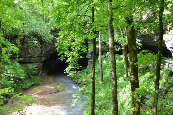
Russell Cave National Monument
National Monument
Russell Cave National Monument is an archeological site with one of the most complete records of prehistoric cultures in the Southeast. In the 1950s, archeologists uncovered a large quantity of artifa...
24 mi from route
~61 min detour
Free
near mile 40.1
Park data from the National Park Service API. Alerts update every 2 hours.
More Details
What kind of drive is this?
Expect a trip defined by its highway-focused nature, with 70% of the route spent on major thoroughfares. You will spend a significant portion of your time on John T Reid Parkway, which features the longest uninterrupted stretch of the journey at 59.3 miles. The road transition between the parkway and I-59 dictates the pace of your travel, moving from local stretches into a more consistent interstate flow. While the drive is practical and functional, the lack of required stops allows you to maintain a steady speed throughout the 2-hour duration. It is a predictable, utilitarian experience designed to get you from point A to point B without unnecessary complexity.
70% highway — fuel and pacing are the main things to plan.
18 navigation steps total — most of the decisions cluster near the start and finish.
Longest single stretch: 59.3 mi on John T Reid Parkway.
How Hard Is This Drive?
5/10
This is a straightforward highway drive that stays mostly on John T Reid Parkway and I 59. You will hit about 10 points where you need to pay attention to lane position or signs. The trickiest moment comes early in the drive near West Main Street.
Driving Effort5/10
Moderate - straightforward overall, but long enough or busy enough to require pacing
Balances navigation complexity with total wheel time.
This drive requires moderate attention. Across 105.7 miles you will encounter 10 spots where lane choice or exit timing matters. Not difficult for experienced highway drivers, but worth previewing the tricky sections before you go.
Where does it get tricky?
The main spots that need attention: near the start (West Main Street): Navigation decision point; at 14.6 miles: Exit ramp - move to the correct lane early. Multiple destination signs - pick the right one; at 40.3 miles: Multiple destination signs - pick the right one.
Elevation Profile
Mostly flat terrain
1,283 ft570 ft
Total Climb
888 ft
Total Descent
1,029 ft
Highest Point
1,283 ft
~30.2 mi in
Elevation Range
712 ft
Towns Mentioned on Route Signs
Based on OSRM destination-sign hints, not a full list of every settlement the road passes.
Between Collinsville, AL and Decatur, AL, road signs point toward 35: Fort Payne and Rainsville.
35: Fort Payne
14.6 mi in|~17m
Rainsville
14.6 mi in|~17m
Who Is This Route For?
Weekend Trip
Doable as a same-day drive at 2h 9m. Total distance: 105.7 miles.
Family Friendly
Moderate complexity with 0 natural rest stops along the way.
Solo Traveler
2h 9m drive, comfortable solo distance.
First-Time Driver
Mostly highway driving (70%). Some complex stretches to watch for.
Frequently Asked Questions
The longest stretch is about 59.3 miles on John T Reid Parkway. The full list of main roads is in the Roads section above.
Yes, with realistic expectations. Build in a stop roughly every 2 hours, have snacks and activities ready, and check the Nearby Places tabs for kid-friendly stops along the way.
The main spots that need attention: near the start (West Main Street): Navigation decision point; at 14.6 miles: Exit ramp - move to the correct lane early. Multiple destination signs - pick the right one; at 40.3 miles: Multiple destination signs - pick the right one.
Yes — Russell Cave National Monument. See the National Parks section for detour distances and tips on detours.
Yes. A round trip is manageable in a single day if you plan a break at Decatur, AL before heading back.