Origin
Chatham, NY
Afternoon in Chatham on Tuesday
Local time
12:10 PM
EDT
Current temp
43°F
Unavailable
Live forecast
Compiled and reviewed by the US Trip Planner planning team at COD Solutions Oy · Last reviewed Apr 21, 2026 · Editorial standards
Drive Time
6h 11m
Distance
316 mi
509 km
Drive Score
8/10
Great drive
Same Day?
Yes, doable
Fuel Cost
$52
one way
EV Charging
Unknown
Estimated drive times based on typical traffic patterns. Actual times may vary with weather, construction, and real-time conditions.

Chatham, NY
Peter Olexa

Buffalo, NY
Wikimedia Commons
Chatham, NY to Buffalo, NY is 316 miles and takes about 6h 11m via New York State Thruway, with a fuel budget near $52 and enough daylight to finish in a day. This drive stays within New York State, taking you from the Northeast region to another part of the Northeast. It's a single-day trip, so you'll want to get an early start to make the most of your driving time. While it's primarily highway, expect a fair amount of turns and local road segments, making it a bit more involved than a pure interstate journey. Plan for one stop to break up the approximately 6-hour travel time.
Trip Pace
Same-day drive is realistic
A same-day return is possible, but it will make for a full day on the road.
Break Rhythm
1 planned break
Plan on a short reset every 3 to 4 hours to stay fresh behind the wheel.
Midpoint
158 miles from Chatham, NY
A natural place for your longest stop of the day , about 3h 5m into the drive .
| Road | Distance | Duration |
|---|---|---|
| New York State Thruway | 287.2 mi | 5h 32m |
| New York State Thruway Berkshire Connector | 14.5 mi | 16m |
| Kensington Expressway | 6.4 mi | 8m |
| Taconic State Parkway | 2.3 mi | 3m |
| State Highway 295 | 2 mi | 2m |
| Spring Street | 0.5 mi | 1m |
| Genesee Street | 0.3 mi | <1m |
| Birge Hill Road | 0.2 mi | <1m |
Step-by-step road directions between Chatham, NY and Buffalo, NY.
Start on Austerlitz Street
Enter roundabout onto Austerlitz Street
Continue on Austerlitz Street
Turn left onto NY 295
Continue on NY 295
Turn right onto Birge Hill Road
Take the ramp
Merge onto Taconic State Parkway
Keep slight left at fork
Continue on this road
Merge onto I 90
Keep slight right at fork
Merge onto I 87
Keep slight left at fork onto I 90
Take the exit
Merge onto NY 33
Keep slight left at fork
Continue on Oak Street
Turn right onto Genesee Street
Turn right onto East Huron Street
Turn left onto Franklin Street
Turn right onto Genesee Street
Enter roundabout onto NY 384
Arrive at destination
Given the 6h 11m duration, leaving Chatham, NY early in the morning is your best bet to arrive in Buffalo with daylight to spare. You'll want to plan for one significant stop to refuel and stretch your legs, especially since the longest continuous driving segment is nearly 288 miles. The fuel cost is estimated around $52, so factor that into your budget. Keep an eye out for the transition between the main Thruway and the Berkshire Connector, as this is where the route begins to weave through more local roads. Being a single-day drive, you have the flexibility to adjust your timing slightly, but an early departure will make for a more relaxed journey.
Morning Departure
Start early — leave by 6-7 AM to arrive at a reasonable hour.
Evening Departure
This is a long drive — plan for a morning departure or consider splitting it into two days.
This is a comfortable same-day trip.
Departure
Before you leave
Start with fuel, water, and navigation already sorted so the first hour feels easy.
First stop
Around 70 miles or 1h 23m in
Use this first pause for coffee, a restroom break, and a quick traffic check ahead.
Halfway reset
Around 158 miles or 3h 5m in
This is the best place for your longest stop, a real meal, and a full fuel check.
Final approach
Final hour starts around 5h 2m
Traffic, exits, and arrival timing usually matter more near Buffalo, NY than in the middle of the route.
Open the route before leaving Chatham, NY so your first major turns are already loaded.
Leave with enough water and a charging cable within reach, not packed away.
Check your fuel range against the first long segment, especially if you are starting outside city service areas.
Day 1
Settle into the route from Chatham, NY
This is one driving day of about 316 miles and 6h 11m.
Rest stops, refuel points, and overnight suggestions along this route.

Mid-route town
Meal stop
158 mi into the route
Best for: Lunch, fuel, and a longer reset
This sits close to the middle of the route, so it works well for the longest stop of the day.
A short stop after about 70 miles helps settle the day before fatigue starts building.
The midpoint is around 158 miles from Chatham, NY, which is a good place for a longer meal and fuel stop.
Before the longest stretch
Fuel checkTop up before New York State Thruway if your tank is already low. That segment runs about 287.2 miles.
These stop ideas are pacing suggestions — the exact town or exit can change with traffic, hotel plans, and fuel range.
5 decision points cluster between mile 20.4 and 315.7 — GPS handles the exact turns, but know they're coming. Your lane choice matters more than the turn itself.
Keep slight right at fork toward I 87 North: Albany, Buffalo
Highway fork - watch signs carefully. Lane positioning matters here. Multiple destination signs - pick the right one
Keep slight left at fork onto I 90 / New York State Thruway toward I 90 West: Buffalo
Highway fork - watch signs carefully. Lane positioning matters here
Take the exit toward NY 33 West: Buffalo
Exit ramp - move to the correct lane early. Lane positioning matters here
Keep slight left at fork toward Oak Street
Highway fork - watch signs carefully. Lane positioning matters here
Turn left onto Franklin Street
Lane positioning matters here
Regular Gas
$52.02 one way
$104.03 round trip
| Fuel Type | $/gal | One Way | Round Trip |
|---|---|---|---|
| midgrade | $4.52 | $56.25 | $112.49 |
| premium | $4.92 | $61.25 | $122.49 |
| diesel | $5.61 | $69.77 | $139.54 |
Estimated Tolls: $15.08
Toll estimates based on average 2024-2025 rates. EZ-Pass/SunPass discounts may lower the actual cost.
Estimated Trip Cost (one way, 1 person)
Fuel
$52
Tolls
$15
Meals
$25–$50
Total
$92–$117
Rough estimate based on US averages. Hotel $80–$140/night, meals $25–$50/day.
Estimated CO2 emission: 110.6 kg one way. Prices: EIA weekly data, 2026-04-13.
Driving Electric?
About $33 in charging · 1 stop · 67% less CO2
| Vehicle Type | kWh | Stops | DC Fast | Home Charge |
|---|---|---|---|---|
| Average EV | 94.8 | 1 | $33.18 | $15.17 |
| Efficient EV | 79 | 0 | $27.65 | $12.64 |
| EV Truck/SUV | 126.4 | 1 | $44.24 | $20.22 |
Gas CO2
111 kg
EV CO2
37 kg (67% less)
Plan for 1 charging stop. A 30-minute DC fast charge mid-route should be enough to complete the trip comfortably.
DC fast charging avg $0.35/kWh. Home charging avg $0.16/kWh. US grid CO2: 0.39 kg/kWh.
Current conditions at both ends of the drive.
Origin
Afternoon in Chatham on Tuesday
Local time
12:10 PM
EDT
Current temp
43°F
Unavailable
Destination
Afternoon in Buffalo on Tuesday
Local time
12:10 PM
EDT
Current temp
68°F
Showers And Thunderstorms
58°F
Springfield, NY
158 mi in
Seasonal Notes
Summer travel usually means heavier construction, hotter rest stops, and busier weekend traffic around major cities.
Winter travel shortens daylight, so a route that looks manageable on paper can feel much longer after dark.
Holiday weekends tend to make both departure and arrival windows slower than the raw route time suggests.
Time zone
Origin and destination are on the same clock, so arrival timing is easier to judge at a glance.
Temperature spread
A meaningful temperature swing is a good cue to rethink layers, water, and how soon you want to arrive.
Road read
Start early — leave by 6-7 AM to arrive at a reasonable hour.
Weather data from the National Weather Service. Conditions may change; check closer to your travel date.
Worth a detour if your schedule allows.
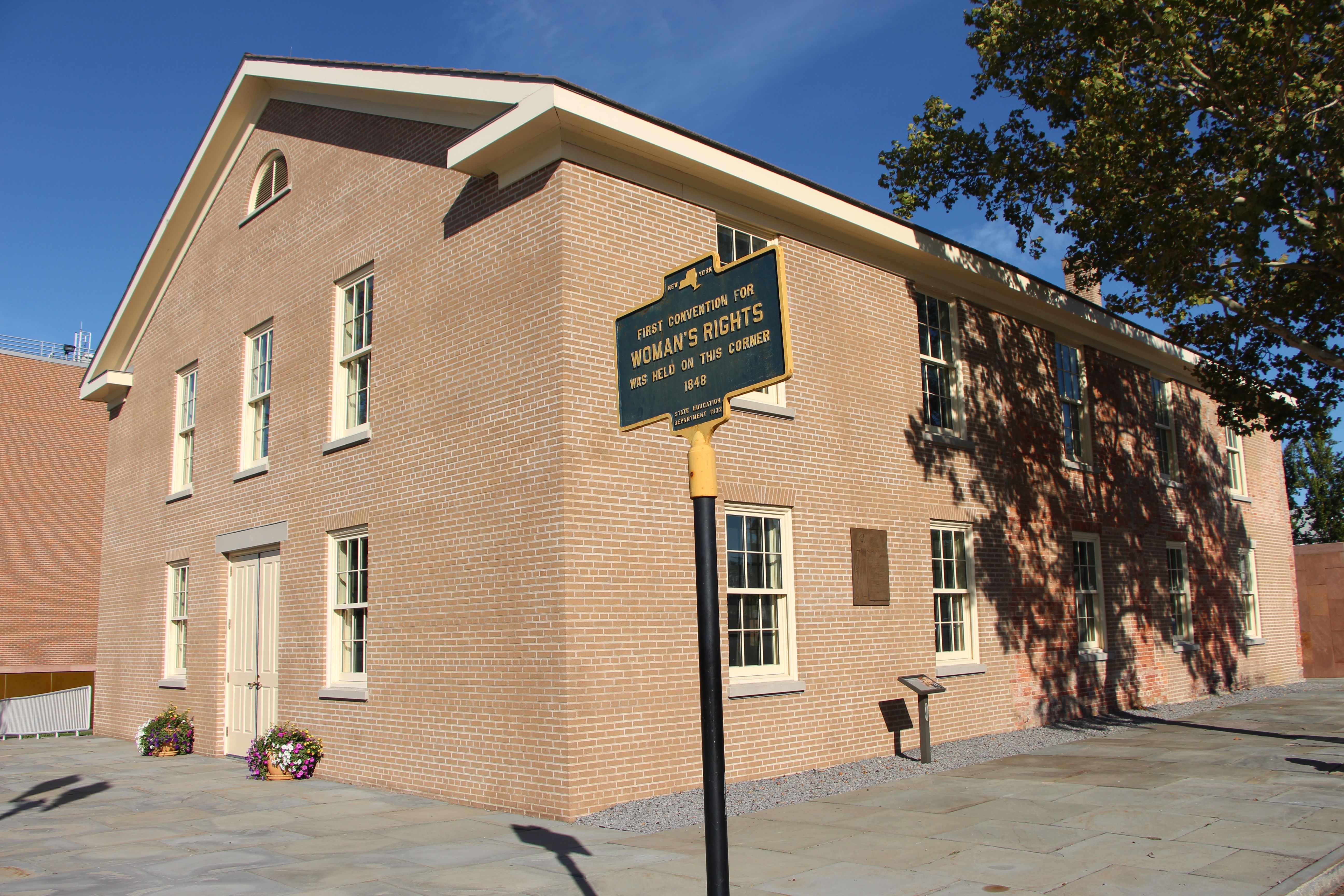
National Historical Park
Women’s Rights National Historical Park tells the story of the first Women’s Rights Convention, held in Seneca Falls, New York on July 19-20, 1848. It is a story of struggles for civil rights, human r...
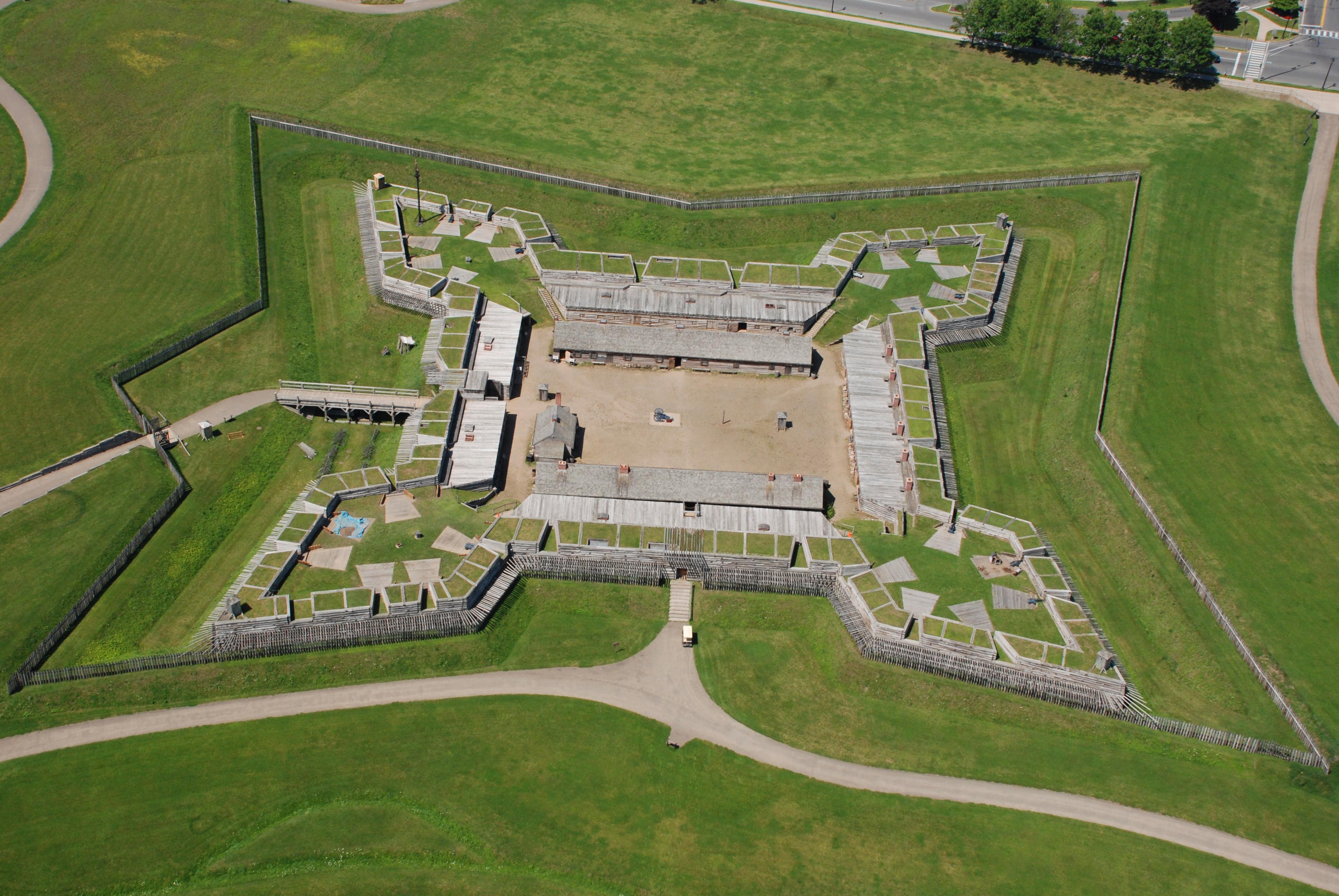
National Monument
For centuries, the Oneida Carrying Place, a six-mile portage connecting the Mohawk River and Wood Creek, served as a vital link for those traveling by water from the ocean to the Great Lakes. When Eur...

National Historical Park
Harriet Tubman was guided by a deep faith and devotion to family, freedom, and community. After emancipating herself and members of her family, she moved them from Ontario, Canada to Fleming and Aubur...
National Historical Park
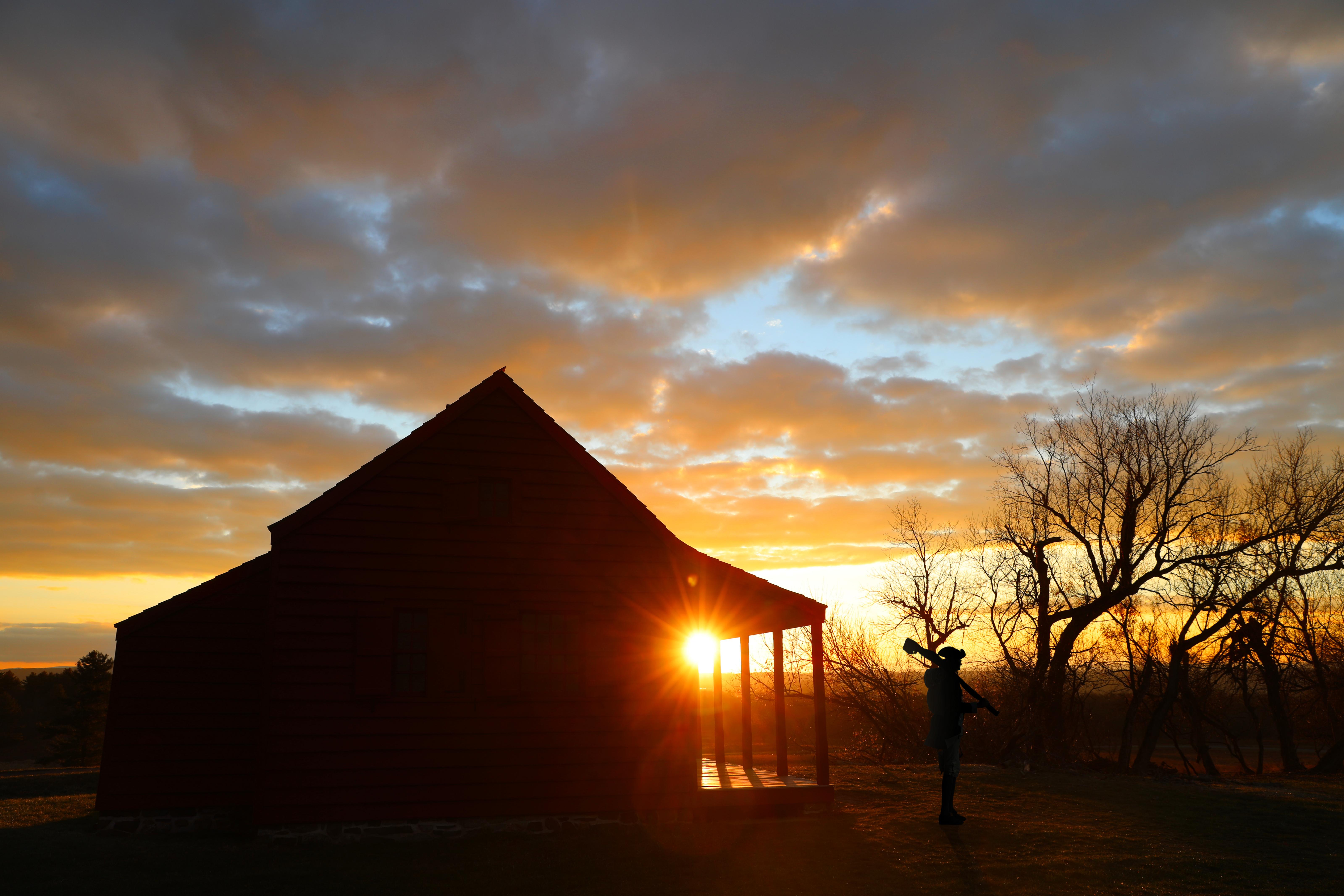
In 1777, a large British invasion force met an equally large American army here at Saratoga. After two intense battles, an eight-mile retreat, and a three-day siege, British General John Burgoyne surr...
Park data from the National Park Service API. Alerts update every 2 hours.
This route offers a "turn-heavy local drive" profile, meaning you won't be on a monotonous interstate for the entire 316 miles. With a 3 out of 5 highway share, expect a mix of faster-paced road sections and more winding, local stretches. The longest uninterrupted stretch you'll encounter is 287.2 miles, primarily on the New York State Thruway, which will allow for some solid cruising. However, be prepared for the road to change character as you navigate through various towns and cities within New York. The "turn-heavy" aspect suggests you'll be actively steering and navigating more frequently than on a typical straight highway drive.
Expect a hands-on drive with frequent turns and local roads rather than long highway stretches. This route has several spots where lane changes, forks, or exits need your full attention. The trickiest moment comes around 20.4 miles in.
High effort - long or complex enough to need steady focus all day
Balances navigation complexity with total wheel time.
This is a demanding drive. With 18 significant decision points across 316 miles, you will need to stay alert - especially through interchange areas and urban stretches. Consider splitting it into segments if you are not comfortable with fast highway navigation.
Where does it get tricky?
The main spots that need attention: at 20.4 miles: Highway fork - watch signs carefully. Lane positioning matters here. Multiple destination signs - pick the right one; at 34.4 miles (I 90 / New York State Thruway): Highway fork - watch signs carefully. Lane positioning matters here; at 308.1 miles: Exit ramp - move to the correct lane early. Lane positioning matters here.
Founded 1795
Top landmarks
Founded 1832
The largest city in New York State's Niagara Frontier, Buffalo is a city full of surprises. Though Buffalo is sometimes the butt of jokes about chicken wings, its long-suffering sports teams, and the mountains of snow under which it is supposedly buried each winter, those in the know tell a different story: one of vibrant nightlife, world-class museums and cultural attractions, tight-knit neighborhoods with strong community spirit – and the sunniest summers in Northeastern United States.
Top landmarks
City content from Wikivoyage (CC BY-SA 4.0) and Wikidata (CC0).
Weekend Trip
Doable as a same-day drive at 6h 11m. Total distance: 316 miles.
Family Friendly
Moderate complexity with 1 natural rest stops along the way.
Solo Traveler
6h 11m drive, plan rest stops for pacing.
Scenic Drive
Mostly surface roads route profile with national parks nearby.
Compiled by the US Trip Planner planning team at COD Solutions Oy from open government datasets — OSRM over OpenStreetMap for geometry, EIA for fuel prices, and NPS for national parks. See our methodology for refresh cadence and limitations.
Was this helpful?
Thanks for your feedback!
Your tip has been submitted. Thanks!
/500
Recent Tips
·
Explore more options from Chatham, NY or browse trips ending in Buffalo, NY.
Looking for more statewide routes? Browse NY road trips.