Origin
Brunswick, GA
Night in Brunswick on Saturday
Local time
9:18 PM
EDT
Current temp
72°F
Unavailable
Live forecast
Compiled and reviewed by the US Trip Planner planning team at COD Solutions Oy · Last reviewed Apr 19, 2026 · Editorial standards
Drive Time
6h 13m
Distance
333.2 mi
536 km
Drive Score
8/10
Great drive
Same Day?
Yes, doable
Fuel Cost
$52
one way
EV Charging
Unknown
Estimated drive times based on typical traffic patterns. Actual times may vary with weather, construction, and real-time conditions.

Brunswick, GA
Joshua Brown

Alpharetta, GA
Wikimedia Commons
This 302.9-mile journey from Brunswick, GA to Alpharetta, GA is best tackled in a single day, taking approximately 5 hours and 11 minutes. With a fuel cost estimated at $48, it's an economical trip. The route primarily utilizes local roads, with no highway driving, making it a more involved, turn-heavy experience. You'll be navigating through the Southeast region of Georgia for the entirety of this drive. Plan for at least one stop along the way, and be prepared for a less direct, more engaging drive that requires your attention.
Trip Pace
Same-day drive is realistic
A same-day return is possible, but it will make for a full day on the road.
Break Rhythm
1 planned break
Plan on a short reset every 3 to 4 hours to stay fresh behind the wheel.
Midpoint
166.6 miles from Brunswick, GA
A natural place for your longest stop of the day , about 3h 4m into the drive .
| Road | Distance | Duration |
|---|---|---|
| Jim Gillis Historic Savannah Parkway | 155.9 mi | 2h 47m |
| I 75 | 84.9 mi | 1h 35m |
| I 95 | 62.5 mi | 1h 7m |
| Turner McDonald Parkway | 11 mi | 13m |
| T Harvey Mathis Parkway | 7.1 mi | 8m |
| Northeast Expressway | 2.7 mi | 3m |
| Newcastle Street | 2.4 mi | 3m |
| New Jesup Highway | 1.8 mi | 3m |
Step-by-step road directions between Brunswick, GA and Alpharetta, GA.
Start on Norwich Street
Turn left onto US 25; GA 25 Connector
Turn right onto New Castle Street
Turn straight onto Newcastle Street
Continue on US 25; US 341; GA 27
Continue on US 25; US 341; GA 27
Continue on US 25; US 341; GA 27
Take the ramp
Merge onto I 95
Keep slight right at fork onto I 95
Take the exit
Merge onto I 16
Continue on I 16; GA 540
Keep slight right at fork
Merge onto I 75
Keep slight left at fork onto I 75
Keep slight left at fork onto I 85
Keep slight right at fork onto GA 400
Continue on GA 400
Take the exit
Turn left onto Haynes Bridge Road
Turn left onto GA 120
Turn right onto GA 9
Turn right onto Academy Street
Arrive at destination
Given the 5-hour and 11-minute duration and the turn-heavy nature of this 302.9-mile route, starting your drive early in the morning, ideally before 9 AM, will help you avoid heavier local traffic. With a recommended single day for this trip, you can be flexible with your single stop; consider a mid-morning break to stretch your legs. Keep an eye on your fuel gauge, as consistent stops and starts on local roads can consume fuel differently than highway cruising. The $48 fuel estimate is a good baseline, but it's always wise to be prepared for slight variations.
Morning Departure
Start early — leave by 6-7 AM to arrive at a reasonable hour.
Evening Departure
This is a long drive — plan for a morning departure or consider splitting it into two days.
This is a comfortable same-day trip.
Departure
Before you leave
Start with fuel, water, and navigation already sorted so the first hour feels easy.
First stop
Around 73 miles or 1h 24m in
Use this first pause for coffee, a restroom break, and a quick traffic check ahead.
Halfway reset
Around 166.6 miles or 3h 4m in
This is the best place for your longest stop, a real meal, and a full fuel check.
Final approach
Final hour starts around 4h 59m
Traffic, exits, and arrival timing usually matter more near Alpharetta, GA than in the middle of the route.
Open the route before leaving Brunswick, GA so your first major turns are already loaded.
Leave with enough water and a charging cable within reach, not packed away.
Check your fuel range against the first long segment, especially if you are starting outside city service areas.
Day 1
Settle into the route from Brunswick, GA
This is one driving day of about 333.2 miles and 6h 13m.
Rest stops, refuel points, and overnight suggestions along this route.

Mid-route town
Meal stop
167 mi into the route
Best for: Lunch, fuel, and a longer reset
This sits close to the middle of the route, so it works well for the longest stop of the day.
A short stop after about 73 miles helps settle the day before fatigue starts building.
The midpoint is around 166.6 miles from Brunswick, GA, which is a good place for a longer meal and fuel stop.
Before the longest stretch
Fuel checkTop up before Jim Gillis Historic Savannah Parkway if your tank is already low. That segment runs about 155.9 miles.
These stop ideas are pacing suggestions — the exact town or exit can change with traffic, hotel plans, and fuel range.
5 decision points cluster between mile 68.4 and 331.1 — GPS handles the exact turns, but know they're coming. Your lane choice matters more than the turn itself.
Take the exit toward I 16 West: Macon
Exit ramp - move to the correct lane early. Lane positioning matters here
Keep slight right at fork toward I 75 North: Atlanta
Highway fork - watch signs carefully. Lane positioning matters here
Keep slight left at fork onto I 75 toward I 75 North: Atlanta, Birmingham
Highway fork - watch signs carefully. Lane positioning matters here. Multiple destination signs - pick the right one
Keep slight right at fork onto GA 400 / T Harvey Mathis Parkway toward GA 400 North: Buckhead, Cumming
Highway fork - watch signs carefully. Lane positioning matters here. Multiple destination signs - pick the right one
Take the exit toward Alpharetta, Haynes Bridge Road
Exit ramp - move to the correct lane early. Lane positioning matters here. Multiple destination signs - pick the right one
Regular Gas
$52.11 one way
$104.21 round trip
| Fuel Type | $/gal | One Way | Round Trip |
|---|---|---|---|
| midgrade | $4.34 | $56.97 | $113.94 |
| premium | $4.70 | $61.67 | $123.34 |
| diesel | $5.61 | $73.57 | $147.13 |
No toll roads detected on this route.
Estimated Trip Cost (one way, 1 person)
Fuel
$52
Meals
$25–$50
Total
$77–$102
Rough estimate based on US averages. Hotel $80–$140/night, meals $25–$50/day.
Estimated CO2 emission: 116.6 kg one way. Prices: EIA weekly data, 2026-04-13.
Driving Electric?
About $35 in charging · 1 stop · 67% less CO2
| Vehicle Type | kWh | Stops | DC Fast | Home Charge |
|---|---|---|---|---|
| Average EV | 100 | 1 | $34.99 | $15.99 |
| Efficient EV | 83.3 | 0 | $29.15 | $13.33 |
| EV Truck/SUV | 133.3 | 1 | $46.65 | $21.32 |
Gas CO2
117 kg
EV CO2
39 kg (67% less)
Plan for 1 charging stop. A 30-minute DC fast charge mid-route should be enough to complete the trip comfortably.
DC fast charging avg $0.35/kWh. Home charging avg $0.16/kWh. US grid CO2: 0.39 kg/kWh.
Current conditions at both ends of the drive.
Origin
Night in Brunswick on Saturday
Local time
9:18 PM
EDT
Current temp
72°F
Unavailable
Destination
Night in Alpharetta on Saturday
Local time
9:18 PM
EDT
Current temp
52°F
Unavailable
Seasonal Notes
Summer travel usually means heavier construction, hotter rest stops, and busier weekend traffic around major cities.
Winter travel shortens daylight, so a route that looks manageable on paper can feel much longer after dark.
Holiday weekends tend to make both departure and arrival windows slower than the raw route time suggests.
Time zone
Origin and destination are on the same clock, so arrival timing is easier to judge at a glance.
Temperature spread
A meaningful temperature swing is a good cue to rethink layers, water, and how soon you want to arrive.
Road read
Start early — leave by 6-7 AM to arrive at a reasonable hour.
Weather data from the National Weather Service. Conditions may change; check closer to your travel date.
Worth a detour if your schedule allows.

National Historical Park
Welcome to Martin Luther King, Jr. National Historical Park & Preservation District where a young boy grows up in a time of segregation. He was moved by destiny to lead the modern civil rights movemen...

National Historical Park
Welcome to Ocmulgee Mounds National Historical Park. This park is a prehistoric American Indian site, where many different American Indian cultures occupied this land for thousands of years. American...

National Recreation Area
Today the river valley attracts us for so many reasons. Take a solitary walk to enjoy nature’s display, raft leisurely through the rocky shoals with friends, fish the misty waters as the sun comes up,...
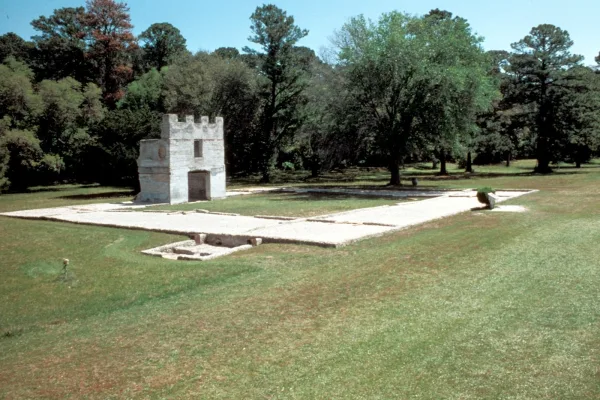
National Monument
War was imminent as James Oglethorpe established Fort Frederica in 1736, to help protect the British colonies from the Spanish in Florida. Fort Frederica illustrates the story of the War of Jenkins Ea...

National Monument
For much of the 19th century, masonry fortifications were the United States’ main defense against overseas enemies. However, during the Civil War, new technology proved its superiority over these fort...
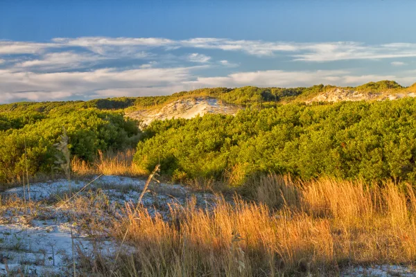
National Seashore
St Marys is the gateway to Cumberland Island, Georgia's largest and southernmost barrier island. Here pristine maritime forests, undeveloped beaches and wide marshes whisper the stories of both man an...
Park data from the National Park Service API. Alerts update every 2 hours.
Expect a 'turn-heavy local drive' for this entire 302.9-mile trip, as the highway share is 0%. This means you'll be on surface streets and local roads for the full duration, with no long stretches of uninterrupted highway. The primary roads you'll be using include Gloucester Street, New Castle Street, and Newcastle Street. The nature of this route suggests frequent turns and potentially slower speeds as you pass through various communities. It's a drive that keeps you engaged with the changing scenery and local traffic patterns.
This is a straightforward highway drive that stays mostly on Jim Gillis Historic Savannah Parkway and I 75. This route has several spots where lane changes, forks, or exits need your full attention. The trickiest moment comes around 68.4 miles in.
Demanding - plan breaks and stay ahead of the key maneuvers
Balances navigation complexity with total wheel time.
This is a demanding drive. With 16 significant decision points across 333.2 miles, you will need to stay alert - especially through interchange areas and urban stretches. Consider splitting it into segments if you are not comfortable with fast highway navigation.
Where does it get tricky?
The main spots that need attention: at 68.4 miles: Exit ramp - move to the correct lane early. Lane positioning matters here; at 224.9 miles: Highway fork - watch signs carefully. Lane positioning matters here; at 287.5 miles (I 75): Highway fork - watch signs carefully. Lane positioning matters here. Multiple destination signs - pick the right one.
Based on OSRM destination-sign hints, not a full list of every settlement the road passes.
Between Brunswick, GA and Alpharetta, GA, road signs point toward Savannah, Birmingham and Cumming.
Savannah
Birmingham
Cumming
Weekend Trip
Doable as a same-day drive at 6h 13m. Total distance: 333.2 miles.
Family Friendly
Moderate complexity with 1 natural rest stops along the way.
Solo Traveler
6h 13m drive, plan rest stops for pacing.
Compiled by the US Trip Planner planning team at COD Solutions Oy from open government datasets — OSRM over OpenStreetMap for geometry, EIA for fuel prices, and NPS for national parks. See our methodology for refresh cadence and limitations.
Was this helpful?
Thanks for your feedback!
Your tip has been submitted. Thanks!
/500
Recent Tips
·
Explore more options from Brunswick, GA or browse trips ending in Alpharetta, GA.
Looking for more statewide routes? Browse GA road trips.