Traveling from Blanding to Orem covers 271.8 miles through the heart of the Mountain West, a journey that typically takes about 5 hours and 27 minutes. Because this is a manageable distance, you can easily complete the trip in a single day without needing an overnight stop. You will navigate via the Dinosaur Diamond Prehistoric Highway, North Grayson Parkway, and Veterans Memorial Highway. Budgeting roughly $43 for fuel should cover your needs for the duration of the drive. It is a straightforward route that transitions from the remote landscapes of southeastern Utah toward the urban corridor of the north, making it a functional connection between the two regions.
Trip Pace
Same-day drive is realistic
A same-day return is possible, but it will make for a full day on the road.
Break Rhythm
1 planned break
Plan on a short reset every 3 to 4 hours to stay fresh behind the wheel.
Midpoint
135.9 miles from Blanding, UT
A natural place for your longest stop of the day
, about 2h 42m into the drive
.
Toward I 15 North: Salt Lake CityUse the straight / slight right lanes.
17
Merge onto I 15
13 mi·13 min·Veterans Memorial Highway
Use the straight / slight right lanes.
18
Take the exit
0.2 mi·29 sec
Exit 271Toward Orem, Center StreetUse the slight right lane.
19
Keep slight right at fork
448 ft·12 sec
Use the right lane.
20
Turn straight onto West Center Street
1.5 mi·3 min·West Center Street
21
Continue on East Center Street
223 ft·7 sec·East Center Street
Use the left / straight lanes.
22
Turn right
173 ft·13 sec
23
Turn sharp right onto US 89
135 ft·7 sec·State Street
24
Arrive at destination
US 89
Trip Plan
Since this is a one-day trip, departing early in the morning is your best strategy to avoid fatigue and maximize daylight. Plan for at least one dedicated stop during your 5-hour and 27-minute trek to stretch your legs and refuel. Keep in mind that your fuel costs will hover around $43, so check your levels before tackling the 172.1-mile stretch on the Dinosaur Diamond Prehistoric Highway to ensure you do not run low in a remote area. Because you only have one mandatory stop built into this 271.8-mile route, you have plenty of flexibility to adjust your itinerary based on traffic or personal preference. Staying alert during the long highway segments will make your transition into the Orem area much smoother.
Morning Departure
An early start around 7-8 AM gets you there with plenty of daylight left.
Evening Departure
A late afternoon start means arriving after dark. Morning is better.
You can normally do this drive in one day.
Plan roughly 1 meaningful break for fuel, food, and rest.
The halfway point lands around 135.9 miles from Blanding, UT, or about 2h 42m into the drive.
The longest continuous stretch on this route runs about 172.1 miles.
This is a comfortable same-day trip.
Departure
Before you leave
Start with fuel, water, and navigation already sorted so the first hour feels easy.
First stop
Around 60 miles or 1h 16m in
Use this first pause for coffee, a restroom break, and a quick traffic check ahead.
Halfway reset
Around 135.9 miles or 2h 42m in
This is the best place for your longest stop, a real meal, and a full fuel check.
Final approach
Final hour starts around 4h 27m
Traffic, exits, and arrival timing usually matter more near Orem, UT than in the middle of the route.
Before You Leave
+
Open the route before leaving Blanding, UT so your first major turns are already loaded.
+
Leave with enough water and a charging cable within reach, not packed away.
+
Check your fuel range against the first long segment, especially if you are starting outside city service areas.
Day 1
Settle into the route from Blanding, UT
This is one driving day of about 271.8 miles and 5h 27m.
Your first comfortable stop window is around 60 miles from Blanding, UT.
This route can stay practical as a one-day drive if traffic stays reasonable.
Plan about 1 real break rather than only quick fuel stops.
The longest stretch is on Dinosaur Diamond Prehistoric Highway for about 172.1 miles.
Where to Stop
Rest stops, refuel points, and overnight suggestions along this route.
Place data sourced from public business listings. Hours and availability may vary.
Heads-up: tricky spots
5 of 12
5 decision points cluster between mile 106.1 and 270.1 — GPS handles the exact turns, but know they're coming. Your lane choice matters more than the turn itself.
6
106.1 mi into trip|~2h 12m in|US 191
Take the exit onto US 191 toward I-70 West
Exit ramp - move to the correct lane early
Toward I-70 West
6
130 mi into trip|~2h 35m in|US 6; US 191
Take the exit onto US 6; US 191 toward US 6 West, US 191 North: Price, Salt Lake City
Exit ramp - move to the correct lane early. Multiple destination signs - pick the right one
Exit 157
Toward US 6 West, US 191 North: Price, Salt Lak...
7
257 mi into trip|~5h 9m in
Take the exit toward I 15 North: Salt Lake City
Exit ramp - move to the correct lane early. Lane positioning matters here
Use the straight / slight right lanes.
Toward I 15 North: Salt Lake City
8
269.8 mi into trip|~5h 23m in
Take the exit toward Orem, Center Street
Exit ramp - move to the correct lane early. Lane positioning matters here. Multiple destination signs - pick the right one
Use the slight right lane.
Exit 271
Toward Orem, Center Street
7
270.1 mi into trip|~5h 23m in
Keep slight right at fork
Highway fork - watch signs carefully. Lane positioning matters here
Use the right lane.
Fuel & Cost
Regular Gas
$42.36 one way
$84.73 round trip
$3.96/gal25.4 MPG avg95 kg CO2
Fuel Type
$/gal
One Way
Round Trip
midgrade
$4.17
$44.65
$89.31
premium
$4.47
$47.88
$95.75
diesel
$4.80
$51.32
$102.64
No toll roads detected on this route.
Estimated Trip Cost (one way, 1 person)
Fuel
$42
Meals
$25–$50
Total
$67–$92
Rough estimate based on US averages. Hotel $80–$140/night, meals $25–$50/day.
Estimated CO2 emission: 95.1 kg one way.
Prices: EIA weekly data, 2026-07-13.
Driving Electric?
About $29 in charging
· 1 stop
· 66% less CO2
Vehicle Type
kWh
Stops
DC Fast
Home Charge
Average EV
81.5
1
$28.54
$13.05
Efficient EV
68
0
$23.78
$10.87
EV Truck/SUV
108.7
1
$38.05
$17.40
Gas CO2
95 kg
EV CO2
32 kg (66% less)
Plan for 1 charging stop. A 30-minute DC fast charge mid-route should be enough to complete the trip comfortably.
DC fast charging avg $0.35/kWh. Home charging avg $0.16/kWh. US grid CO2: 0.39 kg/kWh.
Travel Intel
Current conditions at both ends of the drive.
Forecast as of Jul 18, 2026
Origin
Blanding, UT
Late night
in Blanding on Sunday
Local time
3:06 AM
MDT
Current temp
64°F
Chance Showers And Thunderstorms
NE 0 to 5 mph37% chanceLive forecast
Flood Watch
Flood Watch issued July 17 at 10:51PM MDT until July 19 at 12:00AM MDT by NWS Salt Lake City UT
Destination
Orem, UT
Late night
in Orem on Sunday
Local time
3:06 AM
MDT
Current temp
69°F
Partly Cloudy
E 2 mph8% chanceLive forecast
Flood Watch
Flood Watch issued July 17 at 10:51PM MDT until July 19 at 12:00AM MDT by NWS Salt Lake City UT
Seasonal Notes
Summer travel usually means heavier construction, hotter rest stops, and busier weekend traffic around major cities.
Winter travel shortens daylight, so a route that looks manageable on paper can feel much longer after dark.
Holiday weekends tend to make both departure and arrival windows slower than the raw route time suggests.
Time zone
Same local time
Origin and destination are on the same clock, so arrival timing is easier to judge at a glance.
Temperature spread
5 degrees warmer at arrival
A meaningful temperature swing is a good cue to rethink layers, water, and how soon you want to arrive.
Road read
5h 27m on the road
An early start around 7-8 AM gets you there with plenty of daylight left.
Weather data from the National Weather Service. Conditions may change; check closer to your travel date.
National Parks Near This Route
Worth a detour if your schedule allows.
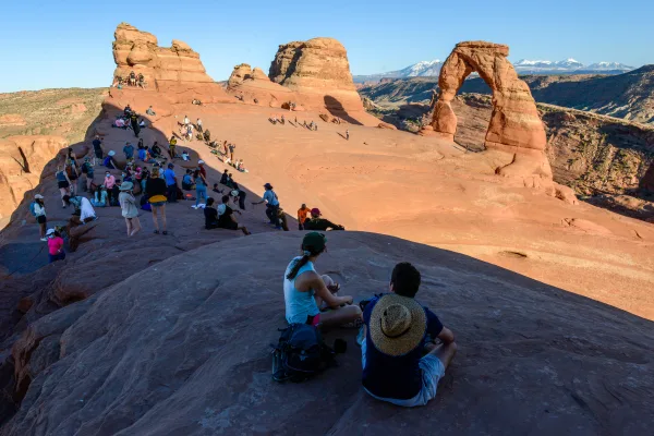
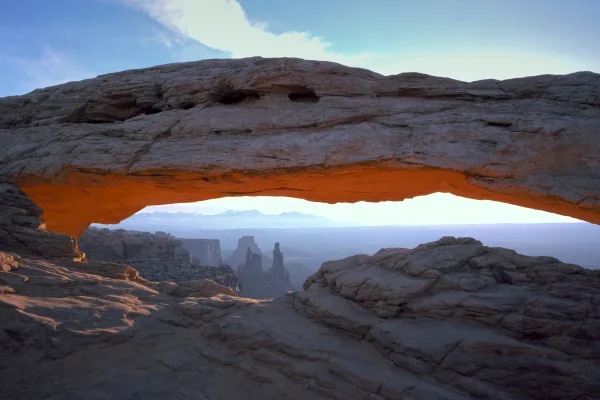
Arches National Park
National Park
Discover a landscape of contrasting colors, land forms, and textures unlike any other. The park has over 2,000 natural stone arches, hundreds of soaring pinnacles, massive rock fins, and giant balance...
The visitor center, caves, and cave tours have not yet opened for the 2026 season. Hike your way past stunning vistas to explore a hidden underground world. Taste the thrill of caving as you twist and...
10 mi from route
~25 min detour
$12
near mile 271.8
Canyonlands is a wilderness of canyons, buttes, and spires carved by the Colorado River and Green River. The park is divided into four distinct districts; no roads join them together. The districts sh...
25 mi from route
~63 min detour
$30
near mile 56.2
Three majestic natural bridges invite you to ponder the power of water in a landscape usually defined by its absence. View them from an overlook, or hit the trails and experience their grandeur from b...
Park data from the National Park Service API. Alerts update every 2 hours.
More Details
What kind of drive is this?
Expect a mixed driving experience that balances long, open stretches with more localized navigation. You will spend about 30% of your time on highways, with your longest uninterrupted stint spanning 172.1 miles along the Dinosaur Diamond Prehistoric Highway. This particular segment defines the core of your journey and requires sustained focus as you traverse the region. The road character evolves as you move from the quieter southern stretches toward the busier infrastructure approaching Orem. Prepare for a ride that alternates between efficient transit and the standard pace of regional roadways.
30% highway, the rest on surface roads — varied driving throughout.
24 navigation steps total — most of the decisions cluster near the start and finish.
Longest single stretch: 172.1 mi on Dinosaur Diamond Prehistoric Highway.
How Hard Is This Drive?
7/10
This route mixes highway mileage with some local-road sections near the start or finish. This route has several spots where lane changes, forks, or exits need your full attention. The trickiest moment comes around 106.1 miles in near US 191.
Driving Effort7/10
Demanding - plan breaks and stay ahead of the key maneuvers
Balances navigation complexity with total wheel time.
This is a demanding drive. With 12 significant decision points across 271.8 miles, you will need to stay alert - especially through interchange areas and urban stretches. Consider splitting it into segments if you are not comfortable with fast highway navigation.
Where does it get tricky?
The main spots that need attention: at 106.1 miles (US 191): Exit ramp - move to the correct lane early; at 130 miles (US 6; US 191): Exit ramp - move to the correct lane early. Multiple destination signs - pick the right one; at 257 miles: Exit ramp - move to the correct lane early. Lane positioning matters here.
Elevation Profile
High-altitude sections with notable climbs
7,235 ft3,989 ft
Total Climb
4,493 ft
Total Descent
5,831 ft
Highest Point
7,235 ft
~213.5 mi in
Elevation Range
3,246 ft
Notable High Points
7,036 ft at ~19.4 miles+924 ft prominence
4,709 ft at ~97.1 miles+300 ft prominence
7,235 ft at ~213.5 miles+1,373 ft prominence
Towns Mentioned on Route Signs
Based on OSRM destination-sign hints, not a full list of every settlement the road passes.
On the drive from Blanding, UT to Orem, UT, road signs begin pointing toward Salt Lake City along the way.
Doable as a same-day drive at 5h 27m. Total distance: 271.8 miles.
Family Friendly
Moderate complexity with 1 natural rest stops along the way.
Solo Traveler
5h 27m drive, comfortable solo distance.
Scenic Drive
Mixed highway & surface route profile with national parks nearby.
Frequently Asked Questions
The longest stretch is about 172.1 miles on Dinosaur Diamond Prehistoric Highway. The full list of main roads is in the Roads section above.
Yes — we found about 12 rest areas or service plazas within a short detour of the route (from OpenStreetMap). See the Rest Stops tab under Nearby Places for locations and mile markers. Plan to stretch, use the bathroom, and top off fluids every 2–3 hours on longer drives.
It helps. This route has a higher-than-average number of complex decision points, which get harder in the dark. If the last hour of the trip is on surface roads or mountain grades, aim to arrive at Orem, UT before sunset when you can. Check the Trip Plan for departure windows that land you in daylight.
Only with planning. This is a long drive for kids — consider splitting it into two days rather than pushing through. Plan at least 1 meaningful breaks. There are 12 rest areas along the route for bathroom stops.
The main spots that need attention: at 106.1 miles (US 191): Exit ramp - move to the correct lane early; at 130 miles (US 6; US 191): Exit ramp - move to the correct lane early. Multiple destination signs - pick the right one; at 257 miles: Exit ramp - move to the correct lane early. Lane positioning matters here.
Yes — Arches National Park, Timpanogos Cave National Monument and Canyonlands National Park (4 total within detour distance). See the National Parks section for detour distances and tips on detours.
Not recommended in a single day. At 5.5 hours each way, a round trip means 10.9 hours of driving — that is an unsafe level of fatigue for most drivers. Plan at least one night at Orem, UT before the return drive.