If you are looking to escape Aurora for a change of scenery in Cripple Creek, this 109.1-mile journey is perfectly suited for a single-day excursion. You should budget about 2 hours and 24 minutes of driving time each way, making it an accessible trip for a weekend getaway. Expect to spend approximately $17 on fuel for the round trip, which remains quite reasonable for a mountain escape. Because the drive is relatively short, you do not need to worry about splitting this into multiple days unless you prefer a slower pace. You will be traveling entirely within the Mountain West region, moving from the suburban landscape of Aurora into the higher elevations of the Colorado mountains. It is a straightforward route that provides a solid balance between highway efficiency and local road navigation.
Trip Pace
Same-day drive is realistic
A same-day return is realistic if you keep stops short.
Midpoint
54.5 miles from Aurora, CO
A natural place for your longest stop of the day
, about 59m into the drive
.
Main Roads
Road
Distance
Duration
South Valley Highway
51.6 mi
54m
South State Highway 67
18.1 mi
31m
Midland Expressway
15.7 mi
23m
I 225
8.3 mi
9m
US 24
6.5 mi
9m
Monument Valley Freeway
3.3 mi
3m
West Fillmore Street
1.4 mi
2m
North 31st Street
0.7 mi
1m
Longest stretch:
South Valley Highway
— 51.6 mi, about 54m
Turn-by-Turn Driving Directions
Step-by-step road directions between Aurora, CO and Cripple Creek, CO.
1
Start on North Vaughn Street
0.2 mi·45 sec·North Vaughn Street
2
At end of road, turn right onto North Zion Street
509 ft·26 sec·North Zion Street
3
Turn left onto Vaughn Street
257 ft·18 sec·Vaughn Street
4
Turn left onto CO 30
0.2 mi·21 sec·East 6th Avenue
5
Take the ramp
0.3 mi·41 sec
Toward I 225 SouthUse the right lane.
6
Merge onto I 225
8.3 mi·9 min·I 225
Use the straight / slight right lanes.
7
Keep slight left at fork
0.4 mi·33 sec
Toward I 25 South: Colorado SpringsUse the slight left / slight right lanes.
8
Keep slight left at fork
0.2 mi·12 sec
9
Merge onto I 25
52 mi·54 min·South Valley Highway
Use the straight / slight right lanes.
10
Continue on I 25
3.3 mi·3 min·Monument Valley Freeway
Use the straight / slight right lanes.
11
Take the exit
0.1 mi·16 sec
Exit 145Toward Fillmore StreetUse the straight / slight right lanes.
12
Keep slight right at fork
232 ft·7 sec
Toward Fillmore Street WestUse the slight right lane.
13
Continue on West Fillmore Street
1.4 mi·2 min·West Fillmore Street
14
Continue on Fontmore Road
0.6 mi·1 min·Fontmore Road
15
Continue on West Fontanero Street
0.3 mi·33 sec·West Fontanero Street
16
Turn left onto North 31st Street
0.7 mi·1 min·North 31st Street
17
Turn sharp right onto US 24
0.2 mi·20 sec·West Cimarron Street
18
Continue on US 24
16 mi·23 min·Midland Expressway
19
Keep slight right at fork onto US 24; CO 67
6.5 mi·9 min·US 24; CO 67
20
Turn left onto CO 67
18 mi·31 min·South State Highway 67
Use the straight lane.
21
Continue on CO 67
0.1 mi·20 sec·North 5th Street
22
Turn right onto East Golden Avenue
0.2 mi·38 sec·East Golden Avenue
23
At end of road, turn left onto North 3rd Street
0.2 mi·45 sec·North 3rd Street
24
Turn right onto CO 67
0.1 mi·29 sec·East Bennett Avenue
25
Arrive at destination
CO 67
Trip Plan
To maximize your experience, aim to depart Aurora early in the morning to beat the heaviest traffic on the South Valley Highway. Since the entire trip is just under 110 miles, you have the advantage of flexibility when it comes to scheduling your departure and return. You will cover a significant stretch of 51.6 miles without a planned stop, so ensure your vehicle is fueled up before you hit the main highway segments. Keep in mind that since there are no mandatory stops listed, you should plan your own breaks along the route based on the local road transitions. A great tip for this specific drive is to monitor your fuel levels before leaving the highway, as gas availability can fluctuate once you transition onto the more remote sections of State Highway 67.
Morning Departure
Leave by 9 AM and you'll arrive before lunch.
Evening Departure
Even a 4 PM departure gets you there before dark in summer.
You can normally do this drive in one day.
You may only need one short stretch break if traffic stays light.
The halfway point lands around 54.5 miles from Aurora, CO, or about 59m into the drive.
The longest continuous stretch on this route runs about 51.6 miles.
This is a comfortable same-day trip.
Departure
Before you leave
Start with fuel, water, and navigation already sorted so the first hour feels easy.
First stop
Around 24 miles or 27m in
Use this first pause for coffee, a restroom break, and a quick traffic check ahead.
Halfway reset
Around 54.5 miles or 59m in
This is the best place for your longest stop, a real meal, and a full fuel check.
Final approach
Final hour starts around 1h 49m
Traffic, exits, and arrival timing usually matter more near Cripple Creek, CO than in the middle of the route.
Before You Leave
+
Open the route before leaving Aurora, CO so your first major turns are already loaded.
+
Leave with enough water and a charging cable within reach, not packed away.
+
Check your fuel range against the first long segment, especially if you are starting outside city service areas.
Day 1
Settle into the route from Aurora, CO
This is one driving day of about 109.1 miles and 2h 24m.
Your first comfortable stop window is around 24 miles from Aurora, CO.
This route can stay practical as a one-day drive if traffic stays reasonable.
The longest stretch is on South Valley Highway for about 51.6 miles.
Where to Stop
Rest stops, refuel points, and overnight suggestions along this route.
Place data sourced from public business listings. Hours and availability may vary.
Heads-up: tricky spots
5 of 16
5 decision points cluster between mile 0.2 and 64.8 — GPS handles the exact turns, but know they're coming. Your lane choice matters more than the turn itself.
6
0.2 mi into trip|~0m in|North Zion Street
At end of road, turn right onto North Zion Street
Complex interchange - multiple decisions in a short stretch
6
0.6 mi into trip|~1m in
Take the ramp toward I 225 South
Lane positioning matters here
Use the right lane.
Toward I 225 South
7
9.2 mi into trip|~12m in
Keep slight left at fork toward I 25 South: Colorado Springs
Highway fork - watch signs carefully. Lane positioning matters here
Use the slight left / slight right lanes.
Toward I 25 South: Colorado Springs
7
64.7 mi into trip|~1h 10m in
Take the exit toward Fillmore Street
Exit ramp - move to the correct lane early. Lane positioning matters here
Use the straight / slight right lanes.
Exit 145
Toward Fillmore Street
8
64.8 mi into trip|~1h 11m in
Keep slight right at fork toward Fillmore Street West
Highway fork - watch signs carefully. Lane positioning matters here
Use the slight right lane.
Toward Fillmore Street West
Fuel & Cost
Regular Gas
$16.44 one way
$32.88 round trip
$3.83/gal25.4 MPG avg38 kg CO2
Fuel Type
$/gal
One Way
Round Trip
midgrade
$4.05
$17.40
$34.81
premium
$4.39
$18.87
$37.75
diesel
$5.61
$24.09
$48.18
No toll roads detected on this route.
Estimated Trip Cost (one way, 1 person)
Fuel
$16
Meals
$25–$50
Total
$41–$66
Rough estimate based on US averages. Hotel $80–$140/night, meals $25–$50/day.
Estimated CO2 emission: 38.2 kg one way.
Prices: EIA weekly data, 2026-04-13.
Driving Electric?
About $11 in charging
· 0 stops
· 66% less CO2
Vehicle Type
kWh
Stops
DC Fast
Home Charge
Average EV
32.7
0
$11.46
$5.24
Efficient EV
27.3
0
$9.55
$4.36
EV Truck/SUV
43.6
0
$15.27
$6.98
Gas CO2
38 kg
EV CO2
13 kg (66% less)
This trip is well within single-charge range for most EVs. No charging stops needed if you start fully charged.
DC fast charging avg $0.35/kWh. Home charging avg $0.16/kWh. US grid CO2: 0.39 kg/kWh.
Travel Intel
Current conditions at both ends of the drive.
Forecast as of Apr 19, 2026
Origin
Aurora, CO
Late night
in Aurora on Tuesday
Local time
3:13 AM
MDT
Current temp
36°F
Unavailable
Live forecast
Destination
Cripple Creek, CO
Late night
in Cripple Creek on Tuesday
Local time
3:13 AM
MDT
Current temp
28°F
Unavailable
Live forecast
Seasonal Notes
Summer travel usually means heavier construction, hotter rest stops, and busier weekend traffic around major cities.
Winter travel shortens daylight, so a route that looks manageable on paper can feel much longer after dark.
Holiday weekends tend to make both departure and arrival windows slower than the raw route time suggests.
Time zone
Same local time
Origin and destination are on the same clock, so arrival timing is easier to judge at a glance.
Temperature spread
8 degrees cooler at arrival
A meaningful temperature swing is a good cue to rethink layers, water, and how soon you want to arrive.
Road read
2h 24m on the road
Use the two city cards together: check the sky where you start, then compare it with the local time and temperature at arrival.
Weather data from the National Weather Service. Conditions may change; check closer to your travel date.
National Parks Near This Route
Worth a detour if your schedule allows.
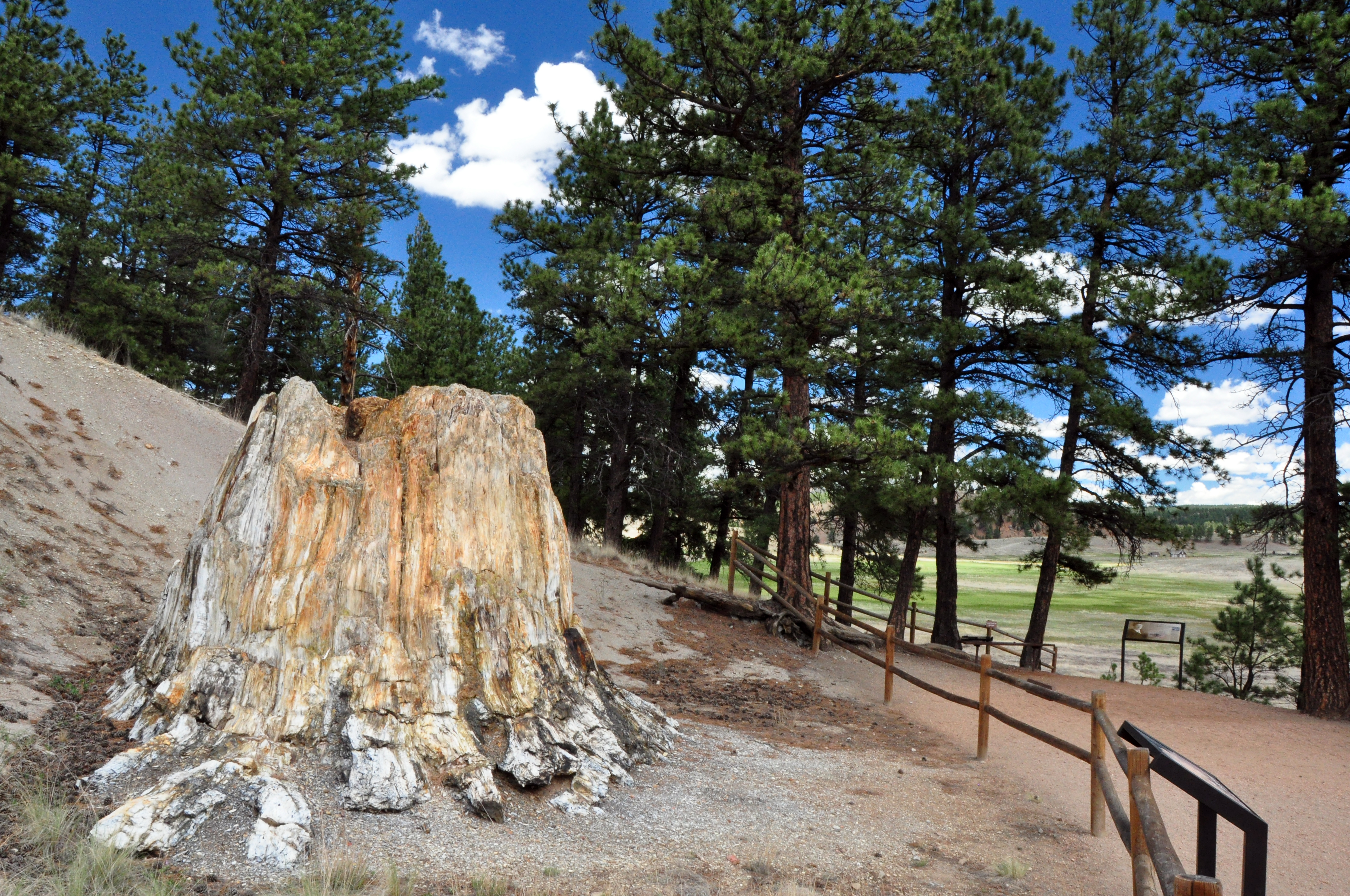
Florissant Fossil Beds National Monument
National Monument
Beneath a grassy mountain valley in central Colorado lies one of the richest and most diverse fossil deposits in the world. Petrified redwood stumps up to 14 feet wide and thousands of detailed fossil...
Park data from the National Park Service API. Alerts update every 2 hours.
More Details
What kind of drive is this?
This trip features a mixed drive profile that keeps the experience varied as you transition between road types. You will spend about 48 percent of your time on highways, with your longest uninterrupted stint covering 51.6 miles along the South Valley Highway. As you move off the main arterials and onto South State Highway 67 and the Midland Expressway, the personality of the road shifts from a standard highway grind to a more technical drive. Navigating these different road classifications means you will experience distinct changes in traffic flow and terrain. Staying alert is key, as the shift from high-speed highway segments to local road stretches requires you to adjust your driving style throughout the 2-hour and 24-minute duration.
48% highway, the rest on surface roads — varied driving throughout.
25 navigation steps total — most of the decisions cluster near the start and finish.
Longest single stretch: 51.6 mi on South Valley Highway.
How Hard Is This Drive?
9/10
This route mixes highway mileage with some local-road sections near the start or finish. This route has several spots where lane changes, forks, or exits need your full attention. The trickiest moment comes around 0.2 miles in near North Zion Street.
Driving Effort9/10
High effort - long or complex enough to need steady focus all day
Balances navigation complexity with total wheel time.
This is a demanding drive. With 16 significant decision points across 109.1 miles, you will need to stay alert - especially through interchange areas and urban stretches. Consider splitting it into segments if you are not comfortable with fast highway navigation.
Where does it get tricky?
The main spots that need attention: at 0.2 miles (North Zion Street): Complex interchange - multiple decisions in a short stretch; at 0.6 miles: Lane positioning matters here; at 9.2 miles: Highway fork - watch signs carefully. Lane positioning matters here.
Towns Mentioned on Route Signs
Based on OSRM destination-sign hints, not a full list of every settlement the road passes.
On the drive from Aurora, CO to Cripple Creek, CO, road signs begin pointing toward Fillmore Street West along the way.
Aurora is a city of about 400,000 of the Denver Metropolitan Area in the western U.S. state of Colorado. The city lies immediately east of Denver in Arapahoe, Adams, and Douglas counties. In 2008 it was named the "All American City."
Top landmarks
•DeLaney Barn
•Blanche A. Wilson House — house
•Plains Conservation Center — park in Colorado, United States of America
Cripple Creek is a small town in Colorado. It is a town steeped in gold mining history, still very much in evidence from the old mine ruins dotted about everywhere. In fact, it promotes itself as "the world's greatest gold camp". In addition, the town is now a major casino destination, as 57% of the residents of Colorado voted to permit this town to have casinos ("controlled gambling") in order to breathe back life into it after it declined in tourism value from the 80s. Today it is a bustling, lively and exciting town that begs exploration of its turn-of-the-20th-century buildings which have been immaculately maintained and makes for brilliant photo opportunities. Watch out though - burros (wild donkeys) roam the streets at large, with the blessing of the townsfolk (except, of course, when the burros are munching up a local garden).
Doable as a same-day drive at 2h 24m. Total distance: 109.1 miles.
Family Friendly
Moderate complexity with 0 natural rest stops along the way.
Solo Traveler
2h 24m drive, comfortable solo distance.
First-Time Driver
Mostly highway driving (48%). Some complex stretches to watch for.
Scenic Drive
Mixed highway & surface route profile with national parks nearby.
Frequently Asked Questions
The longest stretch is about 51.6 miles on South Valley Highway. The full list of main roads is in the Roads section above.
It helps. This route has a higher-than-average number of complex decision points, which get harder in the dark. If the last hour of the trip is on surface roads or mountain grades, aim to arrive at Cripple Creek, CO before sunset when you can. Check the Trip Plan for departure windows that land you in daylight.
Only with planning. This is a long drive for kids — consider splitting it into two days rather than pushing through. Dedicated rest areas are limited, so plan gas or food stops as your bathroom breaks.
The main spots that need attention: at 0.2 miles (North Zion Street): Complex interchange - multiple decisions in a short stretch; at 0.6 miles: Lane positioning matters here; at 9.2 miles: Highway fork - watch signs carefully. Lane positioning matters here.
Yes — Florissant Fossil Beds National Monument. See the National Parks section for detour distances and tips on detours.
Yes. A round trip is manageable in a single day if you plan a break at Cripple Creek, CO before heading back.