Auburn, AL to Bridgeport, AL is 217.8 miles and takes about 4h 33m via US 280 and I-59, with a fuel budget near $33 and enough daylight to finish in a day. This trip stays within Alabama, moving from the Southeast region into another part of the Southeast. Given that most of the drive is on highways, expect a fairly straightforward transit. It's a good option if you need to cover ground efficiently between these two points without a lot of fuss.
Trip Pace
Same-day drive is realistic
A same-day return is possible, but it will make for a full day on the road.
Break Rhythm
1 planned break
Plan on a short reset every 3 to 4 hours to stay fresh behind the wheel.
Midpoint
108.9 miles from Auburn, AL
A natural place for your longest stop of the day
, about 2h 17m into the drive
.
Main Roads
Road
Distance
Duration
US 280
57.3 mi
1h 8m
AL 77
41.1 mi
1h
I 59
37.2 mi
39m
John T Reid Parkway
24.9 mi
28m
South Broadway Avenue
22.7 mi
26m
Tammy Little Drive
12.6 mi
16m
East Main Street
8.9 mi
12m
North College Street
4.8 mi
7m
Longest stretch:
US 280
— 57.3 mi, about 1h 8m
Turn-by-Turn Driving Directions
Step-by-step road directions between Auburn, AL and Bridgeport, AL.
1
Start on this road
291 ft·24 sec·this road
2
At end of road, turn right onto North College Street
4.0 mi·6 min·North College Street
3
Enter roundabout onto AL 147
79 ft·1 sec·North College Street
4
Continue on AL 147
0.7 mi·1 min·North College Street
5
Take the ramp onto AL 147
165 ft·3 sec·North College Street
6
Continue on US 280; AL 147
14 mi·15 min·US 280; AL 147
7
Continue on US 280; AL 50
6.4 mi·7 min·US 280; AL 50
8
Continue on US 280; AL 49
13 mi·15 min·US 280; AL 49
9
Continue on US 280; AL 22
24 mi·29 min·US 280; AL 22
10
Take the exit
0.2 mi·29 sec
11
Turn right
100 ft·2 sec
12
Merge onto AL 21
0.9 mi·1 min·Rockford Highway
13
Continue on AL 21
23 mi·26 min·South Broadway Avenue
14
Turn left onto AL 77
41 mi·1 hr·AL 77
Use the straight lane.
15
Turn left
0.5 mi·1 min
Toward I-59 North: GadsdenUse the left lane.
16
Merge onto I 59
37 mi·39 min·I 59
17
Take the exit
0.3 mi·33 sec
Exit 218Toward 35: Fort Payne, Rainsville
18
Turn left onto AL 35
3.8 mi·5 min·Glenn Boulevard Southwest
19
Continue on AL 35
8.9 mi·12 min·East Main Street
20
Continue on AL 35
13 mi·16 min·Tammy Little Drive
21
Take the ramp
0.3 mi·37 sec
Toward US 72
22
Merge onto US 72
25 mi·28 min·John T Reid Parkway
23
Turn right onto CR 94
1.4 mi·3 min·County Road 94
24
Turn left onto CR 75
0.2 mi·23 sec·Lewis Payne Drive
25
Continue on Broadway Avenue
0.5 mi·1 min·Broadway Avenue
26
Turn right onto 7th Street
389 ft·15 sec·7th Street
27
Turn left onto Alabama Avenue
0.2 mi·29 sec·Alabama Avenue
28
Turn right onto Johnson Street
37 ft·1 sec·Johnson Street
29
Arrive at destination
Johnson Street
Trip Plan
For a 4.5-hour drive, you can easily complete this trip in one day, so leaving in the morning gives you plenty of flexibility. Since there's only one recommended stop, plan to fuel up before you depart Auburn or be mindful of gas stations along US 280 before you hit the longer highway stretches. Keep an eye on your fuel gauge, especially during that 57.3-mile segment on US 280, as services might be less frequent there. The route is predominantly highway, so plan for typical interstate conditions.
Morning Departure
An early start around 7-8 AM gets you there with plenty of daylight left.
Evening Departure
A late afternoon start means arriving after dark. Morning is better.
You can normally do this drive in one day.
Plan roughly 1 meaningful break for fuel, food, and rest.
The halfway point lands around 108.9 miles from Auburn, AL, or about 2h 17m into the drive.
The longest continuous stretch on this route runs about 57.3 miles.
This is a comfortable same-day trip.
Departure
Before you leave
Start with fuel, water, and navigation already sorted so the first hour feels easy.
First stop
Around 48 miles or 58m in
Use this first pause for coffee, a restroom break, and a quick traffic check ahead.
Halfway reset
Around 108.9 miles or 2h 17m in
This is the best place for your longest stop, a real meal, and a full fuel check.
Final approach
Final hour starts around 3h 43m
Traffic, exits, and arrival timing usually matter more near Bridgeport, AL than in the middle of the route.
Before You Leave
+
Open the route before leaving Auburn, AL so your first major turns are already loaded.
+
Leave with enough water and a charging cable within reach, not packed away.
+
Check your fuel range against the first long segment, especially if you are starting outside city service areas.
Day 1
Settle into the route from Auburn, AL
This is one driving day of about 217.8 miles and 4h 33m.
Your first comfortable stop window is around 48 miles from Auburn, AL.
This route can stay practical as a one-day drive if traffic stays reasonable.
Plan about 1 real break rather than only quick fuel stops.
The longest stretch is on US 280 for about 57.3 miles.
Where to Stop
Rest stops, refuel points, and overnight suggestions along this route.
Place data sourced from public business listings. Hours and availability may vary.
Heads-up: tricky spots
5 of 17
5 decision points cluster between mile 0.1 and 217.8 — GPS handles the exact turns, but know they're coming. Your lane choice matters more than the turn itself.
5
0.1 mi into trip|~0m in|North College Street
At end of road, turn right onto North College Street
Navigation decision point
5
85.9 mi into trip|~1h 43m in|AL 77
Turn left onto AL 77
Lane positioning matters here
Use the straight lane.
7
127 mi into trip|~2h 43m in
Turn left toward I-59 North: Gadsden
Lane positioning matters here
Use the left lane.
Toward I-59 North: Gadsden
6
164.7 mi into trip|~3h 24m in
Take the exit toward 35: Fort Payne, Rainsville
Exit ramp - move to the correct lane early. Multiple destination signs - pick the right one
Exit 218
Toward 35: Fort Payne, Rainsville
5
217.8 mi into trip|~4h 33m in|Johnson Street
Turn right onto Johnson Street
Navigation decision point
Fuel & Cost
Regular Gas
$30.23 one way
$60.47 round trip
$3.53/gal25.4 MPG avg76 kg CO2
Fuel Type
$/gal
One Way
Round Trip
midgrade
$3.95
$33.83
$67.66
premium
$4.29
$36.78
$73.55
diesel
$4.80
$41.12
$82.25
No toll roads detected on this route.
Estimated Trip Cost (one way, 1 person)
Fuel
$30
Meals
$25–$50
Total
$55–$80
Rough estimate based on US averages. Hotel $80–$140/night, meals $25–$50/day.
Estimated CO2 emission: 76.2 kg one way.
Prices: EIA weekly data, 2026-07-13.
Driving Electric?
About $23 in charging
· 0 stops
· 67% less CO2
Vehicle Type
kWh
Stops
DC Fast
Home Charge
Average EV
65.3
0
$22.87
$10.45
Efficient EV
54.5
0
$19.06
$8.71
EV Truck/SUV
87.1
1
$30.49
$13.94
Gas CO2
76 kg
EV CO2
25 kg (67% less)
Plan for 0 charging stops, roughly every 270 miles. Allow 25-40 minutes per stop at a DC fast charger.
DC fast charging avg $0.35/kWh. Home charging avg $0.16/kWh. US grid CO2: 0.39 kg/kWh.
Travel Intel
Current conditions at both ends of the drive.
Forecast as of Jul 18, 2026
Origin
Auburn, AL
Late night
in Auburn on Sunday
Local time
5:53 AM
CDT
Current temp
92°F
Chance Showers And Thunderstorms
N 5 mph49% chanceLive forecast
Special Weather Statement
Special Weather Statement issued July 18 at 4:49PM CDT by NWS Mobile AL
Special Weather Statement
Special Weather Statement issued July 18 at 4:43PM CDT by NWS Huntsville AL
Destination
Bridgeport, AL
Late night
in Bridgeport on Sunday
Local time
5:53 AM
CDT
Current temp
89°F
Chance Showers And Thunderstorms
NW 5 mph31% chanceLive forecast
Special Weather Statement
Special Weather Statement issued July 18 at 4:49PM CDT by NWS Mobile AL
Special Weather Statement
Special Weather Statement issued July 18 at 4:43PM CDT by NWS Huntsville AL
Seasonal Notes
Summer travel usually means heavier construction, hotter rest stops, and busier weekend traffic around major cities.
Winter travel shortens daylight, so a route that looks manageable on paper can feel much longer after dark.
Holiday weekends tend to make both departure and arrival windows slower than the raw route time suggests.
Time zone
Same local time
Origin and destination are on the same clock, so arrival timing is easier to judge at a glance.
Temperature spread
3 degrees cooler at arrival
A meaningful temperature swing is a good cue to rethink layers, water, and how soon you want to arrive.
Road read
4h 33m on the road
An early start around 7-8 AM gets you there with plenty of daylight left.
Weather data from the National Weather Service. Conditions may change; check closer to your travel date.
National Parks Near This Route
Worth a detour if your schedule allows.
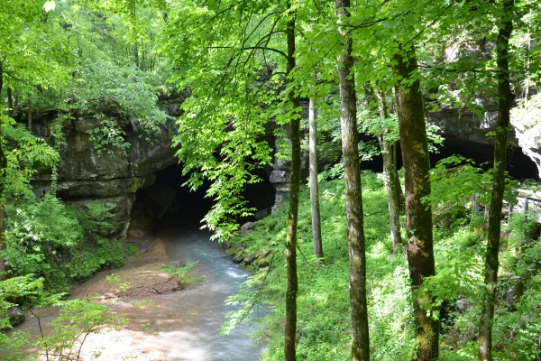
Russell Cave National Monument
National Monument
Russell Cave National Monument is an archeological site with one of the most complete records of prehistoric cultures in the Southeast. In the 1950s, archeologists uncovered a large quantity of artifa...
6 mi from route
~14 min detour
Free
near mile 210.3
In 1961, a small interracial band of “Freedom Riders” challenged discriminatory laws requiring separation of the races in interstate travel. They were attacked by white segregationists, who firebombed...
10 mi from route
~25 min detour
Free
near mile 105.1
Park data from the National Park Service API. Alerts update every 2 hours.
More Details
What kind of drive is this?
This route is mostly highway at 74%, with a significant 57.3-mile stretch on US 280. You'll transition from US 280 to AL 77, and eventually to I-59 for the bulk of your travel. Expect a number of exits and merging traffic as you navigate these main arteries, especially as you get closer to I-59.
74% highway — fuel and pacing are the main things to plan.
29 navigation steps total — most of the decisions cluster near the start and finish.
Longest single stretch: 57.3 mi on US 280.
How Hard Is This Drive?
3/10
This is a straightforward highway drive that stays mostly on US 280 and AL 77. There are only a few real navigation decisions along the way. The trickiest moment comes around 0.1 miles in near North College Street.
Driving Effort3/10
Easy - simple navigation with a manageable amount of wheel time
Balances navigation complexity with total wheel time.
This is a straightforward 4h 33m drive. You will face about 17 decision points, but nothing that requires special attention if you follow navigation.
Where does it get tricky?
The main spots that need attention: at 0.1 miles (North College Street): Navigation decision point; at 85.9 miles (AL 77): Lane positioning matters here; at 127 miles: Lane positioning matters here.
Elevation Profile
Mostly flat terrain
1,259 ft496 ft
Total Climb
857 ft
Total Descent
887 ft
Highest Point
1,259 ft
~171.1 mi in
Elevation Range
763 ft
Towns Mentioned on Route Signs
Based on OSRM destination-sign hints, not a full list of every settlement the road passes.
Between Auburn, AL and Bridgeport, AL, road signs point toward 35: Fort Payne and Rainsville.
Auburn is in the River Heritage region of Alabama, and home to Auburn University in downtown Auburn. During the university's home football games, the town fills up with thousands of alumni and college football fans for a weekend of tailgating.
Top landmarks
•Auburn University Historic District — historic district in Auburn, Alabama
The longest stretch is about 57.3 miles on US 280. The full list of main roads is in the Roads section above.
Yes — we found about 8 rest areas or service plazas within a short detour of the route (from OpenStreetMap). See the Rest Stops tab under Nearby Places for locations and mile markers. Plan to stretch, use the bathroom, and top off fluids every 2–3 hours on longer drives.
Yes, with realistic expectations. Build in a stop roughly every 2 hours, have snacks and activities ready, and check the Nearby Places tabs for kid-friendly stops along the way.
The main spots that need attention: at 0.1 miles (North College Street): Navigation decision point; at 85.9 miles (AL 77): Lane positioning matters here; at 127 miles: Lane positioning matters here.
Yes — Russell Cave National Monument and Freedom Riders National Monument. See the National Parks section for detour distances and tips on detours.
Possible but tiring. At 4.6 hours each way, an in-and-out day trip would put you behind the wheel for 9.1 hours — manageable with a long break at Bridgeport, AL, but most travelers stay overnight.