This 297.7-mile drive from Amherst, NY, to Glens Falls, NY, is a manageable one-day trip, estimated to take about 6 hours and 2 minutes. You'll navigate primarily on the New York State Thruway and the Adirondack Northway, with some sections on Amsterdam Road. With a fuel cost estimated at $49, it's an economical journey. The route is characterized by a turn-heavy local drive feel, suggesting you'll encounter more varied road conditions than a pure interstate experience. This trip stays within the Northeast region, offering a consistent geographical context throughout your travels.
Trip Pace
Same-day drive is realistic
A same-day return is possible, but it will make for a full day on the road.
Break Rhythm
1 planned break
Plan on a short reset every 3 to 4 hours to stay fresh behind the wheel.
Midpoint
148.9 miles from Amherst, NY
A natural place for your longest stop of the day
, about 2h 53m into the drive
.
Main Roads
Road
Distance
Duration
New York State Thruway
246 mi
4h 44m
Adirondack Northway
20 mi
23m
Amsterdam Road
12.6 mi
17m
State Highway 67
4.5 mi
7m
Malta Avenue
3.5 mi
6m
Youngmann Expressway
2.4 mi
3m
Church Street
1.5 mi
4m
NY 30
1 mi
1m
Longest stretch:
New York State Thruway
— 246 mi, about 4h 44m
Traffic on I-87
Hour-of-day weekday pattern from 24 FHWA count stations on your route.
Peak
4 PM
~2,052 veh/hr typical
· worst 2,856
Quietest
1 AM
~98 veh/hr
Peak-to-quiet ratio
20.9×
busier at peak than in the quiet hours
12a6anoon6p11p
Averaged across 52 weeks of 2023 FHWA Travel Monitoring Analysis System data. Weekday hours only (Mon–Fri).
Turn-by-Turn Driving Directions
Step-by-step road directions between Amherst, NY and Glens Falls, NY.
1
Start on NY 263
0.4 mi·50 sec·Millersport Highway
2
Take the ramp
0.3 mi·42 sec
Toward I 290 E
3
Merge onto I 290
2.4 mi·3 min·Youngmann Expressway
4
Keep slight left at fork
0.6 mi·57 sec
Exit 1-49Toward I 90 East: AlbanyUse the slight left / slight right lanes.
5
Merge onto I 90
246 mi·4 hr 44 min·New York State Thruway
Use the straight lane.
6
Take the exit
0.8 mi·1 min
Exit 27Toward NY 30: AmsterdamUse the slight right lane.
7
Continue on this road
367 ft·12 sec·this road
8
Turn right onto NY 30
1.0 mi·1 min·NY 30
9
Keep slight right at fork onto NY 67
1.5 mi·4 min·Church Street
10
Continue on NY 67
4.5 mi·7 min·State Highway 67
11
Continue on NY 67
13 mi·17 min·Amsterdam Road
12
Continue on NY 67
0.6 mi·1 min·West High Street
13
Turn left onto NY 50
0.2 mi·33 sec·Milton Avenue
14
Turn right onto Malta Avenue
3.5 mi·6 min·Malta Avenue
15
Turn left onto US 9
0.4 mi·35 sec·US 9
16
Take the ramp
0.6 mi·1 min
Toward I 87 North
17
Merge onto I 87
20 mi·23 min·Adirondack Northway
18
Take the exit
0.2 mi·31 sec
Exit 18Toward Glens Falls, Corinth
19
Turn right onto CR 28
0.8 mi·1 min·Main Street
20
Continue on Broad Street
0.4 mi·58 sec·Broad Street
21
Turn slight right onto Hudson Avenue
0.7 mi·1 min·Hudson Avenue
22
Enter roundabout onto US 9; NY32
330 ft·18 sec·Centennial Circle
23
Arrive at destination
US 9; NY32
Trip Plan
Given the 6-hour duration, starting early from Amherst, NY, is advisable to maximize your day. While this route is feasible in one day, the 'turn-heavy local drive' profile suggests planning for at least one stop to stretch your legs and break up the driving. The longest stretch is 246 miles, so consider a brief pause before or after this segment. Keep an eye on your fuel, especially as you transition from the major highways to local roads, and budget approximately $49 for fuel costs. Being flexible with your timing will allow you to best adapt to the varied road conditions.
Morning Departure
Start early — leave by 6-7 AM to arrive at a reasonable hour.
Evening Departure
This is a long drive — plan for a morning departure or consider splitting it into two days.
You can normally do this drive in one day.
Plan roughly 1 meaningful break for fuel, food, and rest.
The halfway point lands around 148.9 miles from Amherst, NY, or about 2h 53m into the drive.
The longest continuous stretch on this route runs about 246 miles.
This is a comfortable same-day trip.
Departure
Before you leave
Start with fuel, water, and navigation already sorted so the first hour feels easy.
First stop
Around 65 miles or 1h 16m in
Use this first pause for coffee, a restroom break, and a quick traffic check ahead.
Halfway reset
Around 148.9 miles or 2h 53m in
This is the best place for your longest stop, a real meal, and a full fuel check.
Final approach
Final hour starts around 4h 43m
Traffic, exits, and arrival timing usually matter more near Glens Falls, NY than in the middle of the route.
Before You Leave
+
Open the route before leaving Amherst, NY so your first major turns are already loaded.
+
Leave with enough water and a charging cable within reach, not packed away.
+
Check your fuel range against the first long segment, especially if you are starting outside city service areas.
Day 1
Settle into the route from Amherst, NY
This is one driving day of about 297.7 miles and 6h 2m.
Your first comfortable stop window is around 65 miles from Amherst, NY.
This route can stay practical as a one-day drive if traffic stays reasonable.
Plan about 1 real break rather than only quick fuel stops.
The longest stretch is on New York State Thruway for about 246 miles.
Where to Stop
Rest stops, refuel points, and overnight suggestions along this route.
Place data sourced from public business listings. Hours and availability may vary.
Heads-up: tricky spots
5 of 15
5 decision points cluster between mile 3.1 and 297.7 — GPS handles the exact turns, but know they're coming. Your lane choice matters more than the turn itself.
8
3.1 mi into trip|~4m in
Keep slight left at fork toward I 90 East: Albany
Highway fork - watch signs carefully. Lane positioning matters here
Use the slight left / slight right lanes.
Exit 1-49
Toward I 90 East: Albany
5
3.7 mi into trip|~5m in|I 90 / New York State Thruway
Merge onto I 90 / New York State Thruway
Merge point - match speed before joining. Lane positioning matters here
Use the straight lane.
7
249.8 mi into trip|~4h 50m in
Take the exit toward NY 30: Amsterdam
Exit ramp - move to the correct lane early. Lane positioning matters here
Use the slight right lane.
Exit 27
Toward NY 30: Amsterdam
6
295.5 mi into trip|~5h 56m in
Take the exit toward Glens Falls, Corinth
Exit ramp - move to the correct lane early. Multiple destination signs - pick the right one
Exit 18
Toward Glens Falls, Corinth
5
297.7 mi into trip|~6h 1m in|US 9; NY32 / Centennial Circle
Enter roundabout onto US 9; NY32 / Centennial Circle
Roundabout - know your exit number before entering
Fuel & Cost
Regular Gas
$48.16 one way
$96.32 round trip
$4.11/gal25.4 MPG avg104 kg CO2
Fuel Type
$/gal
One Way
Round Trip
midgrade
$4.46
$52.26
$104.52
premium
$4.85
$56.82
$113.64
diesel
$4.80
$56.21
$112.42
Estimated Tolls: $12.30
New York State Thruway
(246 mi)$12.30
Toll estimates based on average 2024-2025 rates. EZ-Pass/SunPass discounts may lower the actual cost.
Estimated Trip Cost (one way, 1 person)
Fuel
$48
Tolls
$12
Meals
$25–$50
Total
$85–$110
Rough estimate based on US averages. Hotel $80–$140/night, meals $25–$50/day.
Estimated CO2 emission: 104.2 kg one way.
Prices: EIA weekly data, 2026-07-13.
Driving Electric?
About $31 in charging
· 1 stop
· 66% less CO2
Vehicle Type
kWh
Stops
DC Fast
Home Charge
Average EV
89.3
1
$31.26
$14.29
Efficient EV
74.4
0
$26.05
$11.91
EV Truck/SUV
119.1
1
$41.68
$19.05
Gas CO2
104 kg
EV CO2
35 kg (66% less)
Plan for 1 charging stop. A 30-minute DC fast charge mid-route should be enough to complete the trip comfortably.
DC fast charging avg $0.35/kWh. Home charging avg $0.16/kWh. US grid CO2: 0.39 kg/kWh.
Travel Intel
Current conditions at both ends of the drive.
Forecast as of Jul 17, 2026
Origin
Amherst, NY
Late night
in Amherst on Monday
Local time
4:30 AM
EDT
Current temp
83°F
Smoke
SW 9 mph1% chanceLive forecast
Rip Current Statement
Rip Current Statement issued July 17 at 2:45PM EDT until July 18 at 9:00PM EDT by NWS Upton NY
Destination
Glens Falls, NY
Late night
in Glens Falls on Monday
Local time
4:30 AM
EDT
Current temp
82°F
Sunny
NW 5 mph0% chanceLive forecast
Rip Current Statement
Rip Current Statement issued July 17 at 2:45PM EDT until July 18 at 9:00PM EDT by NWS Upton NY
Seasonal Notes
Summer travel usually means heavier construction, hotter rest stops, and busier weekend traffic around major cities.
Winter travel shortens daylight, so a route that looks manageable on paper can feel much longer after dark.
Holiday weekends tend to make both departure and arrival windows slower than the raw route time suggests.
Time zone
Same local time
Origin and destination are on the same clock, so arrival timing is easier to judge at a glance.
Temperature spread
1 degrees cooler at arrival
A meaningful temperature swing is a good cue to rethink layers, water, and how soon you want to arrive.
Road read
6h 2m on the road
Start early — leave by 6-7 AM to arrive at a reasonable hour.
Weather data from the National Weather Service. Conditions may change; check closer to your travel date.
National Parks Near This Route
Worth a detour if your schedule allows.
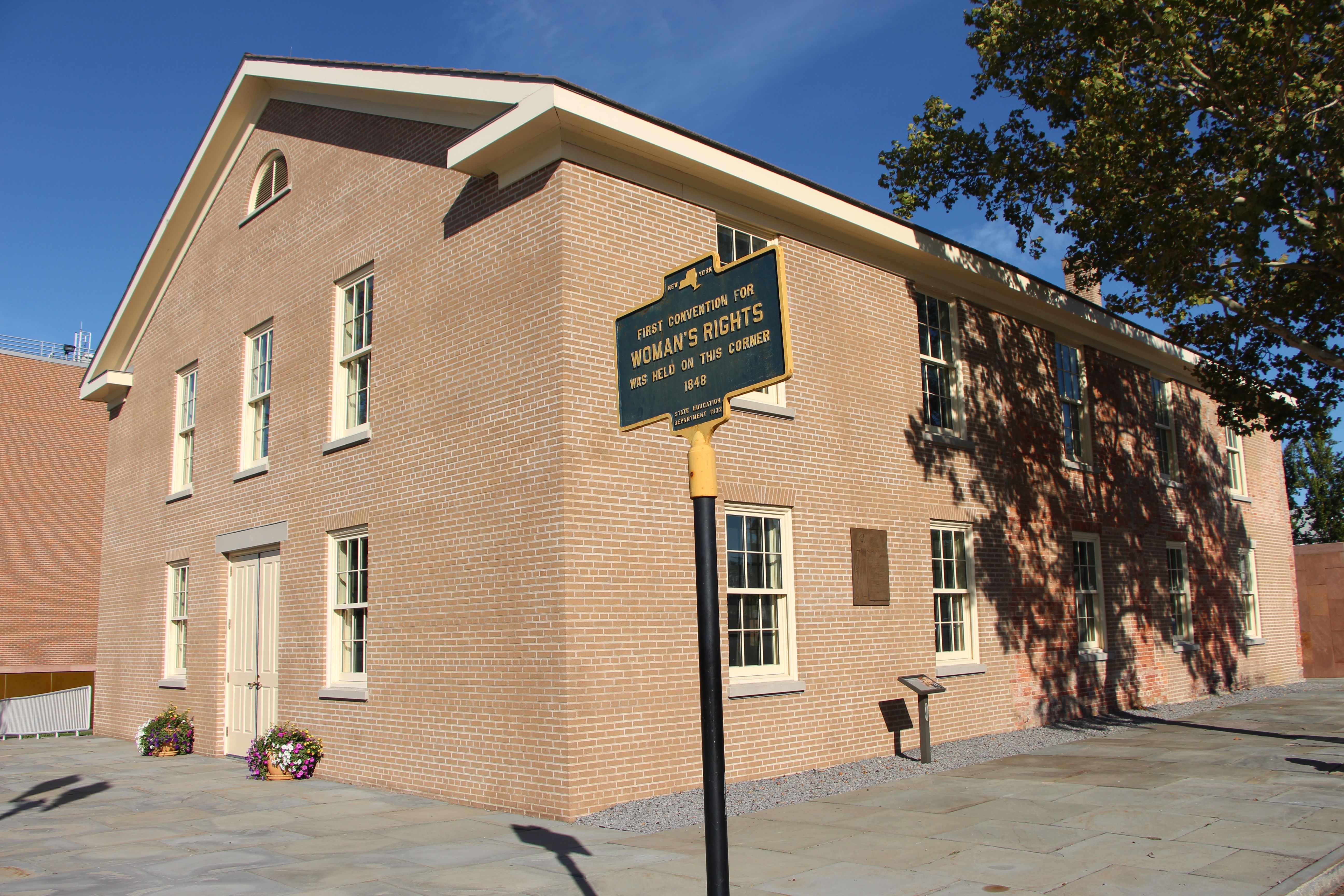
Women's Rights National Historical Park
National Historical Park
Women’s Rights National Historical Park tells the story of the first Women’s Rights Convention, held in Seneca Falls, New York on July 19-20, 1848. It is a story of struggles for civil rights, human r...
5 mi from route
~12 min detour
Free
near mile 102.7
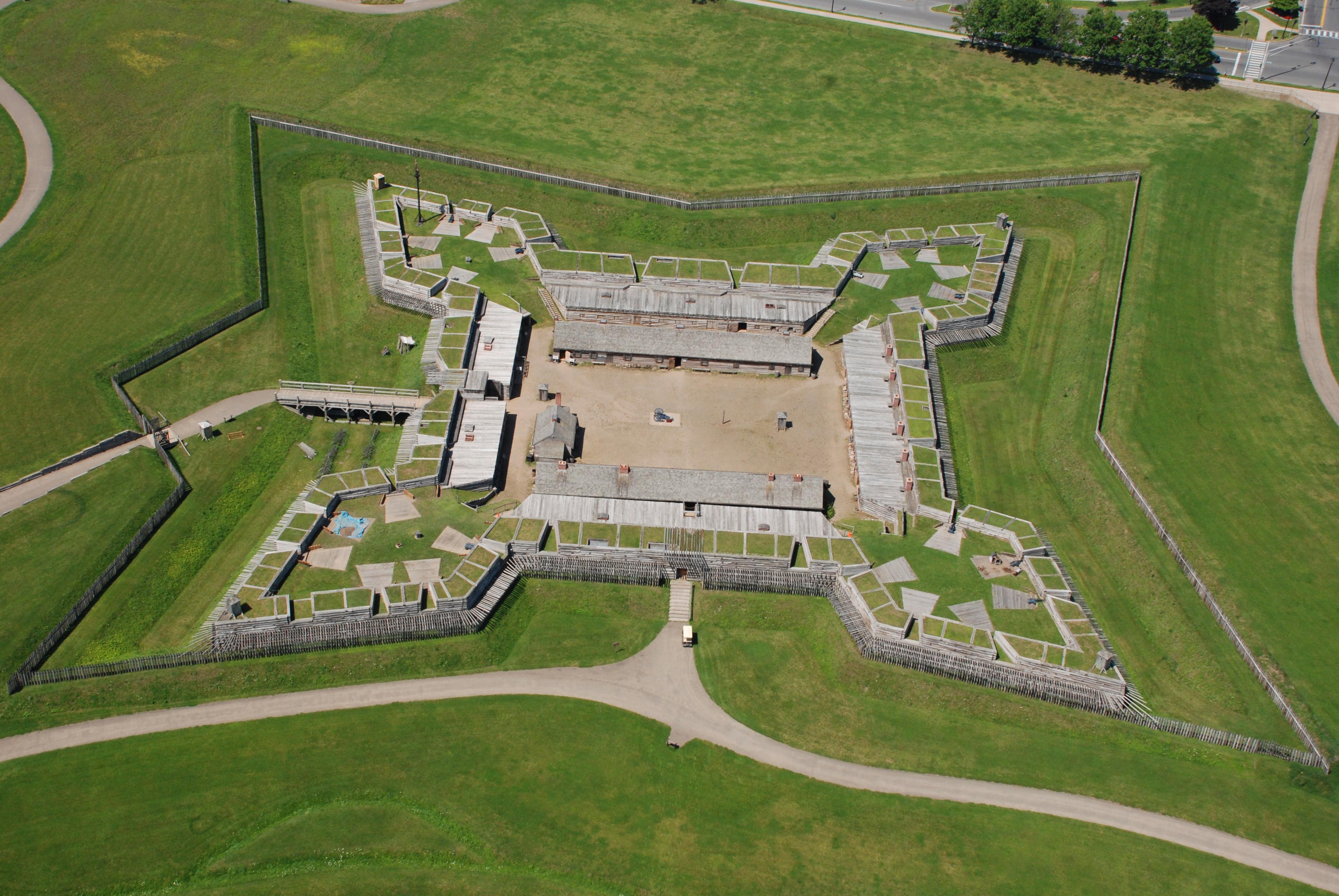
For centuries, the Oneida Carrying Place, a six-mile portage connecting the Mohawk River and Wood Creek, served as a vital link for those traveling by water from the ocean to the Great Lakes. When Eur...
6 mi from route
~15 min detour
Free
near mile 174.5
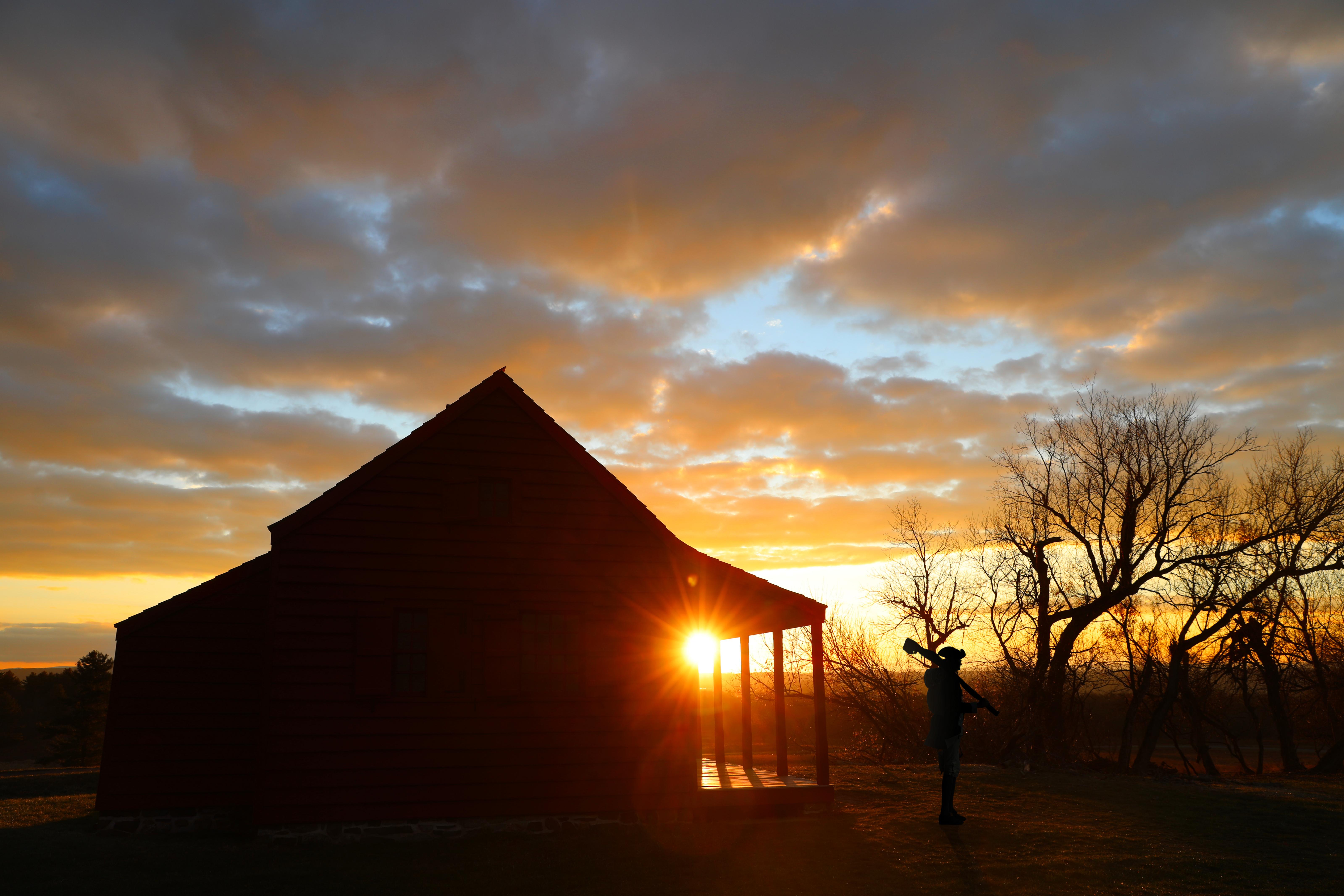
In 1777, a large British invasion force met an equally large American army here at Saratoga. After two intense battles, an eight-mile retreat, and a three-day siege, British General John Burgoyne surr...
8 mi from route
~20 min detour
Free
near mile 277.2
Harriet Tubman was guided by a deep faith and devotion to family, freedom, and community. After emancipating herself and members of her family, she moved them from Ontario, Canada to Fleming and Aubur...
9 mi from route
~24 min detour
Free
near mile 112.9
Park data from the National Park Service API. Alerts update every 2 hours.
More Details
What kind of drive is this?
Expect a drive with a 'turn-heavy local drive' profile, meaning it's not a simple, straight shot. While a significant portion, about 33% of the highway share, involves major roadways like the New York State Thruway and the Adirondack Northway, you'll also encounter local road segments. The longest uninterrupted stretch is a substantial 246 miles on the New York State Thruway, providing a good opportunity for consistent cruising. However, be prepared for a dynamic driving experience with frequent changes in road type and direction as you progress towards Glens Falls.
Only 3% highway — the rest is turn-by-turn surface driving.
23 navigation steps total — most of the decisions cluster near the start and finish.
Longest single stretch: 246 mi on New York State Thruway.
How Hard Is This Drive?
6/10
Expect a hands-on drive with frequent turns and local roads rather than long highway stretches. You will hit about 15 points where you need to pay attention to lane position or signs. The trickiest moment comes around 3.1 miles in.
Driving Effort6/10
Moderate - straightforward overall, but long enough or busy enough to require pacing
Balances navigation complexity with total wheel time.
This drive requires moderate attention. Across 297.7 miles you will encounter 15 spots where lane choice or exit timing matters. Not difficult for experienced highway drivers, but worth previewing the tricky sections before you go.
Where does it get tricky?
The main spots that need attention: at 3.1 miles: Highway fork - watch signs carefully. Lane positioning matters here; at 3.7 miles (I 90 / New York State Thruway): Merge point - match speed before joining. Lane positioning matters here; at 249.8 miles: Exit ramp - move to the correct lane early. Lane positioning matters here.
Doable as a same-day drive at 6h 2m. Total distance: 297.7 miles.
Family Friendly
Moderate complexity with 1 natural rest stops along the way.
Solo Traveler
6h 2m drive, plan rest stops for pacing.
Scenic Drive
Mostly surface roads route profile with national parks nearby.
Frequently Asked Questions
The longest stretch is about 246 miles on New York State Thruway. The full list of main roads is in the Roads section above.
Expect about $12.30 in tolls one way, starting with New York State Thruway. Most Northeast and Midwest toll agencies accept E-ZPass; in the West and Texas, transponders like TxTag or FasTrak apply. If you do not have a transponder, cashless tolling plates will mail a bill to the vehicle's registered address — usually with a surcharge, so a rental-car toll pass is often cheaper than paying by mail.
Yes — we found about 34 rest areas or service plazas within a short detour of the route (from OpenStreetMap). See the Rest Stops tab under Nearby Places for locations and mile markers. Plan to stretch, use the bathroom, and top off fluids every 2–3 hours on longer drives.
It helps. This route has a higher-than-average number of complex decision points, which get harder in the dark. If the last hour of the trip is on surface roads or mountain grades, aim to arrive at Glens Falls, NY before sunset when you can. Check the Trip Plan for departure windows that land you in daylight.
Only with planning. This is a long drive for kids — consider splitting it into two days rather than pushing through. Plan at least 1 meaningful breaks. There are 34 rest areas along the route for bathroom stops.
The main spots that need attention: at 3.1 miles: Highway fork - watch signs carefully. Lane positioning matters here; at 3.7 miles (I 90 / New York State Thruway): Merge point - match speed before joining. Lane positioning matters here; at 249.8 miles: Exit ramp - move to the correct lane early. Lane positioning matters here.
Yes — Women's Rights National Historical Park, Fort Stanwix National Monument and Saratoga National Historical Park (4 total within detour distance). See the National Parks section for detour distances and tips on detours.
Not recommended in a single day. At 6.0 hours each way, a round trip means 12.1 hours of driving — that is an unsafe level of fatigue for most drivers. Plan at least one night at Glens Falls, NY before the return drive.